
Search found 5754 matches
- Fri Jan 08, 2016 1:16 am
- Forum: Weather Forum
- Topic: January 2016: Mardi Gras WX Outlook
- Replies: 385
- Views: 184970
Re: January 2016: Chilly & Unsettled Pattern Ahead
Temps have really underperformed in CLL today and tonight. Omen of a cold column when the dam breaks?
- Tue Jan 05, 2016 9:18 pm
- Forum: Weather Forum
- Topic: January 2016: Mardi Gras WX Outlook
- Replies: 385
- Views: 184970
Re: January 2016: Chilly & Unsettled Pattern Ahead
Band - NE Texas through NC. That's long, long way out...snowman65 wrote:that would be very interesting for my trip to N. Alabama....hhmmm
- Tue Jan 05, 2016 7:38 pm
- Forum: Weather Forum
- Topic: January 2016: Mardi Gras WX Outlook
- Replies: 385
- Views: 184970
Re: January 2016: Chilly & Unsettled Pattern Ahead
GFS delays the real cold a few days in Neverland and posits a Southern snow event:

- Mon Jan 04, 2016 2:06 pm
- Forum: Weather Forum
- Topic: January 2016: Mardi Gras WX Outlook
- Replies: 385
- Views: 184970
Re: January 2016: Chilly & Unsettled Pattern Ahead
Even the GFS is doubling down on some kind of wintry stuff.MontgomeryCoWx wrote:GFS flip flopping again. It also has a CAT 5 ice storm a week and a half out...

- Sat Jan 02, 2016 8:06 pm
- Forum: Weather Forum
- Topic: January 2016: Mardi Gras WX Outlook
- Replies: 385
- Views: 184970
Re: January 2016: Chilly & Wet New Years Weekend
I disagree...I think the industries best can have a pretty good handle on things 10 days out...not perfect by any means but certainly not wish casting, no disrespect JMO. Another run...Euro and Canadian look alike for mid Jan and the US model is lost. Quantitatively, 5 day forecasts are pretty good...
- Fri Jan 01, 2016 12:02 pm
- Forum: Weather Forum
- Topic: January 2016: Mardi Gras WX Outlook
- Replies: 385
- Views: 184970
Re: January 2016: Chilly & Wet New Years Weekend
Weather (and climate) forecasting is really no different, for the most part, than any other area of science. You look for consensus, robustness of predictions, and the mechanisms and predictable patterns (fractals if you will) underlying the models and predictions. Which models follow mechanistic da...
- Thu Dec 31, 2015 6:11 pm
- Forum: Weather Forum
- Topic: December 2015 -Year Ends As One Of Wettest On Record
- Replies: 355
- Views: 164889
Re: December 2015 -Chilly & Damp New Years Eve Possible
2015 Annual Rainfall Totals for SE Texas from HGX: .CLIMATE... 2015 HAS BEEN A VERY WET YEAR FOR MANY PLACES ACROSS SE TEXAS. THE FOLLOWING TABLE LISTS A RANKING OF THE ANNUAL RAINFALL RECORDS FOR 27 SITES ACROSS SE TEXAS WHICH REACHED INTO THE TOP TEN WETTEST YEARS ON RECORD. THE DATA IS FOR RAINF...
- Thu Dec 31, 2015 3:04 am
- Forum: Weather Forum
- Topic: January 2016: Mardi Gras WX Outlook
- Replies: 385
- Views: 184970
Re: January 2016: Chilly & Wet New Years Weekend
The snow protrudes all the way to the Brazos river on the W side of Brazos Co.srainhoutx wrote:Not sure what got into the 18Z GFS, but it suddenly increases the wintry mix over the Hill Country. And the very long range is a complete flip to very cold Arctic front racing out of Western Canada into the Plains.
- Tue Dec 29, 2015 10:18 pm
- Forum: Weather Forum
- Topic: January 2016: Mardi Gras WX Outlook
- Replies: 385
- Views: 184970
Re: January 2016: Chilly/Wet New Years Weekend Possible
1.5 in of rain IMBY from 7/1/15 - 10/21/15
27.15 in of rain from 10/22/15 - 12/29/15
27.15 in of rain from 10/22/15 - 12/29/15
- Mon Dec 28, 2015 6:42 pm
- Forum: Weather Forum
- Topic: January 2016: Mardi Gras WX Outlook
- Replies: 385
- Views: 184970
Re: January 2016: Chilly/Wet New Years Weekend Possible
It looks like the various reliable computer schemes are coming together suggesting another Great Basin upper low with a rather robust disturbance riding the sub tropical jet out of the Eastern Pacific will bring a round of light precipitation, mostly in the liquid form across the Western and Southe...
- Sun Dec 27, 2015 7:25 pm
- Forum: Weather Forum
- Topic: December 2015 -Year Ends As One Of Wettest On Record
- Replies: 355
- Views: 164889
Re: December 2015 - Tracking High Impact Christmas Storm
Frozen Mischief approaching Lake Travis.nuby3 wrote:I've been wondering if stuff like the cells between Austin and San Antonio might offer some bursts of sleet with their passing
- Sun Dec 27, 2015 4:44 pm
- Forum: Weather Forum
- Topic: December 2015 -Year Ends As One Of Wettest On Record
- Replies: 355
- Views: 164889
Re: December 2015 - Tracking High Impact Christmas Storm
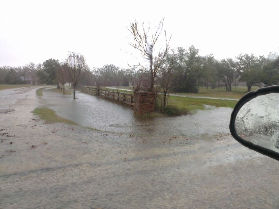
5.5 in of rain IMBY since last night.
- Sun Dec 27, 2015 1:38 pm
- Forum: Weather Forum
- Topic: December 2015 -Year Ends As One Of Wettest On Record
- Replies: 355
- Views: 164889
Re: December 2015 - Tracking High Impact Christmas Storm
Band of snow crossing Junction moving toward Kerrville
- Sun Dec 27, 2015 1:37 pm
- Forum: Weather Forum
- Topic: December 2015 -Year Ends As One Of Wettest On Record
- Replies: 355
- Views: 164889
Re: December 2015 - Tracking High Impact Christmas Storm
ssued by The National Weather Service Houston/Galveston, TX 1:25pm CST, Sun Dec 27 THE NATIONAL WEATHER SERVICE IN LEAGUE CITY HAS ISSUED A * FLOOD ADVISORY FOR... SOUTHEASTERN BURLESON COUNTY IN SOUTHEASTERN TEXAS... NORTHEASTERN WASHINGTON COUNTY IN SOUTHEASTERN TEXAS... BRAZOS COUNTY IN SOUTHEAST...
- Sun Dec 27, 2015 1:25 pm
- Forum: Weather Forum
- Topic: December 2015 -Year Ends As One Of Wettest On Record
- Replies: 355
- Views: 164889
Re: December 2015 - Tracking High Impact Christmas Storm
In the last 24 hours:
3.5 in of rain
-28°F temp change
3.5 in of rain
-28°F temp change
- Sun Dec 27, 2015 1:11 pm
- Forum: Weather Forum
- Topic: December 2015 -Year Ends As One Of Wettest On Record
- Replies: 355
- Views: 164889
Re: December 2015 - Tracking High Impact Christmas Storm
Significant entraining continuing in the CLL area.
- Sun Dec 27, 2015 12:04 pm
- Forum: Weather Forum
- Topic: December 2015 -Year Ends As One Of Wettest On Record
- Replies: 355
- Views: 164889
Re: December 2015 - Tracking High Impact Christmas Storm
rotation cited by storm tracker Bob Pack N of Navasota. Appears to have been short lived, but non the less the rotation was there. Getting some breaks in the clouds in NW Harris County with the LLJ reaching down to the surface. Winds gusting to 35 MPH the past half hour. Power went out for a min or...
- Sun Dec 27, 2015 11:24 am
- Forum: Weather Forum
- Topic: December 2015 -Year Ends As One Of Wettest On Record
- Replies: 355
- Views: 164889
Re: December 2015 - Tracking High Impact Christmas Storm
rotation cited by storm tracker Bob Pack N of Navasota.
- Sun Dec 27, 2015 11:17 am
- Forum: Weather Forum
- Topic: December 2015 -Year Ends As One Of Wettest On Record
- Replies: 355
- Views: 164889
- Sun Dec 27, 2015 11:09 am
- Forum: Weather Forum
- Topic: December 2015 -Year Ends As One Of Wettest On Record
- Replies: 355
- Views: 164889
Re: December 2015 - Tracking High Impact Christmas Storm
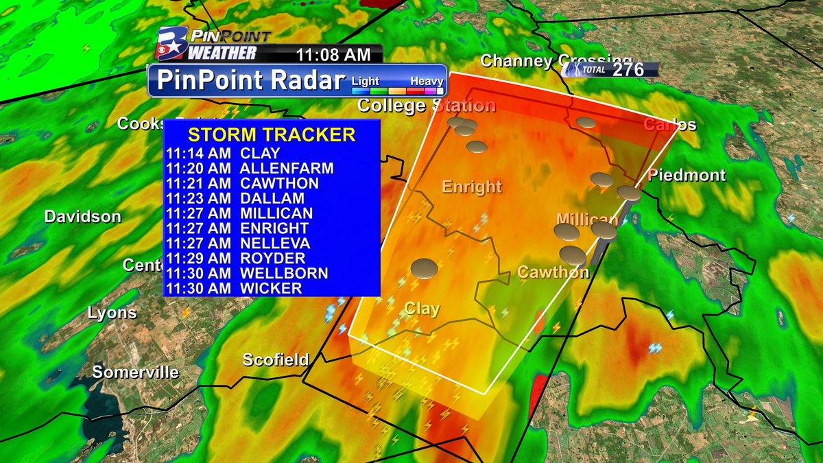
TORNADO WARNING until 11:30 am - getting details.
Washington, Brazos, Burleson Counties. Moving NE at 45 mph - Rotation detected in extreme northern Washington Co.
Washington, Brazos, Burleson Counties. Moving NE at 45 mph - Rotation detected in extreme northern Washington Co.