
Disclaimer: promets and experts feel free to correct me on what I'm seeing.
May 2021:
-
txbear
- Posts: 249
- Joined: Wed Oct 31, 2018 12:54 pm
- Contact:
Still working on understanding Skew-Ts, but this seems like a rough set up for hail. CAPE > 3300, no cap, and elevated shear.
Disclaimer: promets and experts feel free to correct me on what I'm seeing.
Disclaimer: promets and experts feel free to correct me on what I'm seeing.
-
Cpv17
- Posts: 6845
- Joined: Fri Aug 31, 2018 1:58 pm
- Location: El Campo/Wharton
- Contact:
I would love to understand how to read those. I’m clueless lol
-
txbear
- Posts: 249
- Joined: Wed Oct 31, 2018 12:54 pm
- Contact:
Same here! I'm running off limited searches on NWS, SPC, etc. to get some intro knowledge, but would really like to get a much better idea of what I'm seeing in these things.
- I see surfaced based CAPE (energy levels) in the data below the actual chart
- The spread from the red air temp line and the lifted parcel dotted white line is decently big (anything near or to the right of the dotted line would be capped environment)
- Wind barbs out of the SW and increasing in strength particularly at 700mb
- Shear value from SFC - 3km just below the chart has a value of 29; which is conducive for supercells.
But like I said, open to correction and help!
-
BlueJay
- Posts: 938
- Joined: Tue Mar 04, 2014 10:47 am
- Location: Alden Bridge-The Woodlands, Texas
- Contact:
Rumbling of thunder and darkening of skies in The Woodlands.
-
jasons2k

- Posts: 6062
- Joined: Thu Feb 04, 2010 12:54 pm
- Location: Imperial Oaks
- Contact:
There a lot of good online tutorials on YouTube now.
We also have a sub-forum on Storm2k dedicated to meteorology with lots of useful information.
Rumbles of thunder here too. Looking to see if an outflow gets spit out this way. The storm to the north/northwest is not what it was, either (thankfully)
We also have a sub-forum on Storm2k dedicated to meteorology with lots of useful information.
Rumbles of thunder here too. Looking to see if an outflow gets spit out this way. The storm to the north/northwest is not what it was, either (thankfully)
-
don

- Posts: 3118
- Joined: Wed Feb 03, 2010 3:33 pm
- Location: Wichita Falls
- Contact:
Seems correct to me
-
Cromagnum
- Posts: 3028
- Joined: Thu Feb 03, 2011 10:42 pm
- Location: Georgetown
- Contact:
Already firing up on the north side of the area and more out west.
-
jasons2k
- Posts: 6062
- Joined: Thu Feb 04, 2010 12:54 pm
- Location: Imperial Oaks
- Contact:
Outflow on the way. These showers moving-in are low-topped and can’t bust the cap, at least so far. Things could go boom or this party could be over real quick - the usual feast or famine.
-
Cromagnum
- Posts: 3028
- Joined: Thu Feb 03, 2011 10:42 pm
- Location: Georgetown
- Contact:
As soon as the cells get to the LA state line the storms are blowing up.
-
jasons2k
- Posts: 6062
- Joined: Thu Feb 04, 2010 12:54 pm
- Location: Imperial Oaks
- Contact:
Just a thin line of showers here with .05”
That’s OK - we can dry out a little...emphasis on a little.
That’s OK - we can dry out a little...emphasis on a little.
-
jasons2k
- Posts: 6062
- Joined: Thu Feb 04, 2010 12:54 pm
- Location: Imperial Oaks
- Contact:
-
txbear
- Posts: 249
- Joined: Wed Oct 31, 2018 12:54 pm
- Contact:
Think the HRRR got the storms right in general, location was off though with the biggest cluster going north and east...sound familiar? Models are models, not crystal balls.
Cap must be pretty stout south and west considering the dynamics in play. A little more in rain to add to the "reserve tank" in preparation for summer would've been nice.
Cap must be pretty stout south and west considering the dynamics in play. A little more in rain to add to the "reserve tank" in preparation for summer would've been nice.
-
Cpv17
- Posts: 6845
- Joined: Fri Aug 31, 2018 1:58 pm
- Location: El Campo/Wharton
- Contact:
Maybe next week. Rest of this week looks dry.txbear wrote: ↑Tue May 04, 2021 12:48 pm Think the HRRR got the storms right in general, location was off though with the biggest cluster going north and east...sound familiar? Models are models, not crystal balls.
Cap must be pretty stout south and west considering the dynamics in play. A little more in rain to add to the "reserve tank" in preparation for summer would've been nice.
-
don
- Posts: 3118
- Joined: Wed Feb 03, 2010 3:33 pm
- Location: Wichita Falls
- Contact:
Models are showing a stormy pattern again next week as a slow moving front stalls near the coast.With disturbances moving over the state in the northwest flow aloft.We'll see if the trends continue...
-
jasons2k
- Posts: 6062
- Joined: Thu Feb 04, 2010 12:54 pm
- Location: Imperial Oaks
- Contact:
Oh it’s only 10 degrees warmer than forecast....nothing to see here....
-
djmike

- Posts: 1839
- Joined: Fri Jan 07, 2011 12:19 pm
- Location: BEAUMONT, TX
- Contact:
A whole lot of nothing for me in Beaumont. Knew it. Well 2 maaaaaybe 3 drops.
Mike
Beaumont, TX
(IH-10 & College Street)
Beaumont, TX
(IH-10 & College Street)
-
Cpv17
- Posts: 6845
- Joined: Fri Aug 31, 2018 1:58 pm
- Location: El Campo/Wharton
- Contact:
The CPC is seeing this as well:


Definitely looks like a wet pattern could be in the works.
-
Cromagnum
- Posts: 3028
- Joined: Thu Feb 03, 2011 10:42 pm
- Location: Georgetown
- Contact:
Feels really nice outside this morning.
-
unome
- Posts: 3062
- Joined: Fri Feb 12, 2010 6:11 pm
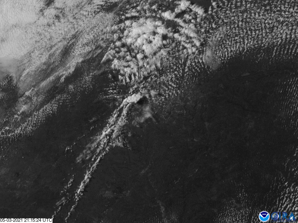
Texas' dry-line weather on May 3rd made the NOAA / NESDIS Image of the Day
with a great explaination of dry-line storm formation
https://twitter.com/NOAASatellites/stat ... 2673552389
https://www.nesdis.noaa.gov/content/goe ... s-dry-line
with a great explaination of dry-line storm formation
https://twitter.com/NOAASatellites/stat ... 2673552389
https://www.nesdis.noaa.gov/content/goe ... s-dry-line
-
DoctorMu

- Posts: 7669
- Joined: Sun Jun 28, 2015 11:58 am
- Location: College Station
- Contact:
If it feels hotter and in the last decade WHEN it (finally) rains it pours (like Harvey and Memorial Day? events), then you're right!
https://www.chron.com/weather/article/g ... 6a35e392f3
https://www.chron.com/weather/article/g ... 6a35e392f3