
I'm worried it keeps a nne heading, it could easily bring heavy rain into Houston metro on that heading. looks like some heavier convection building in from Galveston toward Dwntwn nowsrainhoutx wrote:The Euro was 12 hours slower than the other computer guidance and a run or two suggested a stall...if I recall correctly. I stopped looking at the guidance completely yesterday and focused on satellite and radar data. Getting a bit concerned about our SW and Western areas. There is a lot of rain moving in with at least two feeder bands approaching as Bill lifts N.nuby3 wrote:I distinctly remember there being mention of a stall around Matagorda bay in one of the model runs
JUNE 2015 -Scattered Showers/Storms To End The Month
-
nuby3
- Posts: 387
- Joined: Mon Feb 22, 2010 10:25 pm
- Location: THE WOODLANDS PARKWAY and FM 2978
- Contact:

-
HouTXmetro
- Posts: 78
- Joined: Thu Feb 11, 2010 10:39 pm
- Location: Houston, TX (Medical Center/Reliant Park)
- Contact:
Harris County is about to get in on the action... Training moving in from the SW and pushing NE as nuby stated dead smack in the middle of rush hour I might add.
-
srainhoutx

- Site Admin

- Posts: 19615
- Joined: Tue Feb 02, 2010 2:32 pm
- Location: Maggie Valley, NC
- Contact:
Update from Jeff:
Center of Bill slowly moving inland west of Matagorda Bay.
Heavy Rainfall threat increasing this evening and overnight along and west of I-45.
Discussion:
Bill has moved very slowly inland today, ,but has recently begin to move faster toward the north. Recent development of sustained excessive rainfall from Matagorda County extending over 100 miles into the Gulf of Mexico appears to be the start of several model generated banding features which look to affect the region overnight into Wednesday. Overall structure of the tropical storm has remain in good condition today given its slow inland movement and good fetch of deep tropical moisture which the system resides within.
Rainfall:
Concern remains with bands near and to the east of the center of circulation tonight. Several high resolution models show multiple feeder bands with potential for cell training over areas along and west of I-45 for much of the night into Wednesday. Thus far, rainfall overall has been less than expected, but this air mass remains very capable of high rainfall rates and fairly large rainfall totals. Main culprit to higher rainfall rates and totals tonight will be the degree of sustained convective development which thus far has been lacking. Models are in decent agreement on this banding, but not in great agreement on the placement of the heaviest rainfall axis.
Additional rainfall amounts of 4-6 inches with isolated amounts of 8-10 inches will be possible tonight and Wednesday along and east of the track of the center of Bill or roughly across areas west of I-45 over SE TX.
Tides:
Coastal water level continue to run above normal especially in the NW part of Galveston Bay, along the Gulf beaches, and in Matagorda Bay. Biggest problems continue to be in the NW part of Galveston Bay and Clear Lake where water levels are running 3.0-4.0 ft. Still having issues on Bolivar (SH 87) with overwash debris over the roadway. Tides will gradually come down tonight as wind weaken, but incoming long period swells will result in a slower reduction of the tides than normal.
Winds:
Still a few tropical storm force gusts ongoing over the coastal waters and Matagorda Bay region, but will likely see the tropical storm warning lowered this evening.
Words of Caution:
While Bill has thus far not produced significant rainfall and flooding many times tropical systems such as this produce excessive rainfall after moving inland…sometimes well inland.
Tropical systems like to produce periods of excessive rainfall in the early morning hours when the low level jet maximizes low level convergence. This tends to favor feeder band production and excessive rainfall rates along with pulling in of rainfall near the core of the center of the storm (core rainfall). Both of these remain possibilities tonight over SE TX.
Carla/Alicia/Jerry(In The Eye)/Michelle/Charley/Ivan/Dennis/Katrina/Rita/Wilma/Humberto/Ike/Harvey
Member: National Weather Association
Facebook.com/Weather Infinity
Twitter @WeatherInfinity
Member: National Weather Association
Facebook.com/Weather Infinity
Twitter @WeatherInfinity
-
Katdaddy

- Global Moderator

- Posts: 2502
- Joined: Thu Feb 04, 2010 8:18 am
- Location: League City, Tx
- Contact:
Jeff's update states the overnight flooding concern very well.
Thankfully TS Bill has not produced the heavy widepread flooding rains that have been forecast for past several days across the Houston-Galveston areas. With that said TS Bill is producing heavy rains SW over Matagorda, Wharton, and Lavaca Counties. Decaying tropical cyclones are notorious for nocturnal core rains……Claudette 1979 and Allison 2001 just to name a few. Very heavy tropical rains could develop overnight but this afternoon's Houston-Galveston AFD indicates the most significant flood threat to be W of a Angleton - College Station line. Bottom line, the threat for heavy rains will exist for SE TX until the associated moisture from TS Bill lifts further into the state which should occur later tomorrow afternoon.
Thankfully TS Bill has not produced the heavy widepread flooding rains that have been forecast for past several days across the Houston-Galveston areas. With that said TS Bill is producing heavy rains SW over Matagorda, Wharton, and Lavaca Counties. Decaying tropical cyclones are notorious for nocturnal core rains……Claudette 1979 and Allison 2001 just to name a few. Very heavy tropical rains could develop overnight but this afternoon's Houston-Galveston AFD indicates the most significant flood threat to be W of a Angleton - College Station line. Bottom line, the threat for heavy rains will exist for SE TX until the associated moisture from TS Bill lifts further into the state which should occur later tomorrow afternoon.
-
srainhoutx
- Site Admin
- Posts: 19615
- Joined: Tue Feb 02, 2010 2:32 pm
- Location: Maggie Valley, NC
- Contact:
BULLETIN - EAS ACTIVATION REQUESTED
FLASH FLOOD WARNING
NATIONAL WEATHER SERVICE HOUSTON/GALVESTON TX
551 PM CDT TUE JUN 16 2015
THE NATIONAL WEATHER SERVICE IN LEAGUE CITY HAS ISSUED A
* FLASH FLOOD WARNING FOR...
SOUTHWESTERN BRAZORIA COUNTY IN SOUTHEASTERN TEXAS...
SOUTH CENTRAL COLORADO COUNTY IN SOUTHEASTERN TEXAS...
WHARTON COUNTY IN SOUTHEASTERN TEXAS...
JACKSON COUNTY IN SOUTH CENTRAL TEXAS...
NORTHWESTERN MATAGORDA COUNTY IN SOUTHEASTERN TEXAS...
* UNTIL 845 PM CDT
* AT 548 PM CDT...DOPPLER RADAR INDICATED HEAVY RAIN ACROSS THE
WARNED AREA. 1.5 TO 3.5 INCHES OF RAIN HAVE FALLEN. FLASH FLOODING
IS EXPECTED TO BEGIN SHORTLY.
* SOME LOCATIONS THAT WILL EXPERIENCE FLOODING INCLUDE...
NORTHWESTERN BAY CITY...EL CAMPO...WHARTON...EDNA...GANADO...LA
WARD...VAN VLECK...PIERCE...LOLITA...MARKHAM...BOLING-IAGO...
HUNGERFORD...CORDELE...EGYPT...LAKE TEXANA DAM...MORALES...
DANEVANG...LOUISE AND MIDFIELD.
ADDITIONAL RAINFALL AMOUNTS OF 1 TO 3 INCHES ARE POSSIBLE IN THE
WARNED AREA.
Carla/Alicia/Jerry(In The Eye)/Michelle/Charley/Ivan/Dennis/Katrina/Rita/Wilma/Humberto/Ike/Harvey
Member: National Weather Association
Facebook.com/Weather Infinity
Twitter @WeatherInfinity
Member: National Weather Association
Facebook.com/Weather Infinity
Twitter @WeatherInfinity
I live in Angleton and we are getting a real kick out of watching all of these weather reports showing Angleton being right smack dab in the middle of the yellows & reds and that we have wind gusts of 30+mph. My driveway is barely damp, I could literally mow my yard without wetting my shoes and I could lay a dollar bill on my deck without it blowing away! Lol!
Last edited by unome on Tue Jun 16, 2015 6:53 pm, edited 1 time in total.
I could've gone to work today, but I do not regret staying home. One never knows what these storms will bring.
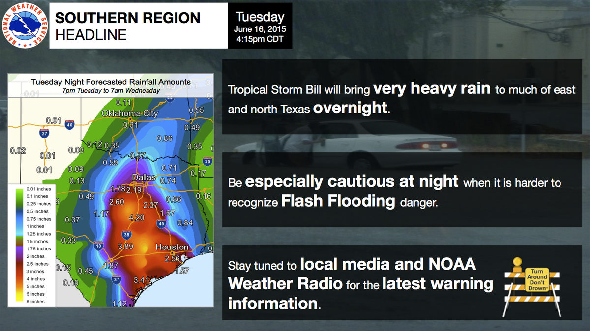
I'm not going anywhere! I am in for the night.unome wrote:sage advice from NWS Southern Region Headquarters

I see NNE as well.
-
Katdaddy
- Global Moderator
- Posts: 2502
- Joined: Thu Feb 04, 2010 8:18 am
- Location: League City, Tx
- Contact:
BULLETIN - EAS ACTIVATION REQUESTED
TORNADO WARNING
NATIONAL WEATHER SERVICE HOUSTON/GALVESTON TX
653 PM CDT TUE JUN 16 2015
THE NATIONAL WEATHER SERVICE IN LEAGUE CITY HAS ISSUED A
* TORNADO WARNING FOR...
SOUTH CENTRAL COLORADO COUNTY IN SOUTHEASTERN TEXAS...
WEST CENTRAL WHARTON COUNTY IN SOUTHEASTERN TEXAS...
NORTH CENTRAL JACKSON COUNTY IN SOUTH CENTRAL TEXAS...
* UNTIL 730 PM CDT
* AT 652 PM CDT...DOPPLER RADAR INDICATED A SEVERE THUNDERSTORM
CAPABLE OF PRODUCING A TORNADO. THIS DANGEROUS STORM WAS LOCATED
NEAR SPEAKS...OR 13 MILES NORTH OF EDNA...AND MOVING NORTHEAST AT
35 MPH. PUBLIC REPORTS TO THE SHERIFFS DEPARTMENT OF A CAR PORT
DAMAGED AND MOTORIST OFF THE ROAD NEAR MORALES.
* LOCATIONS IMPACTED INCLUDE...
CORDELE AND LOUISE.
PRECAUTIONARY/PREPAREDNESS ACTIONS...
TAKE COVER NOW. MOVE TO A BASEMENT OR AN INTERIOR ROOM ON THE LOWEST
FLOOR OF A STURDY BUILDING. AVOID WINDOWS. IF YOU ARE IN A MOBILE
HOME OR OUTDOORS...MOVE TO THE CLOSEST SUBSTANTIAL SHELTER AND
PROTECT YOURSELF FROM FLYING DEBRIS.
MOTORISTS SHOULD NOT TAKE SHELTER UNDER HIGHWAY OVERPASSES. IF YOU
CANNOT SAFELY DRIVE AWAY FROM THE TORNADO...AS A LAST RESORT...EITHER
PARK YOUR VEHICLE AND STAY PUT...OR ABANDON YOUR VEHICLE AND LIE DOWN
IN A LOW LYING AREA AND PROTECT YOURSELF FROM FLYING DEBRIS.
HEAVY RAINFALL MAY OBSCURE THIS TORNADO. DO NOT WAIT TO SEE OR HEAR
THE TORNADO. TAKE COVER NOW.
-
nuby3
- Posts: 387
- Joined: Mon Feb 22, 2010 10:25 pm
- Location: THE WOODLANDS PARKWAY and FM 2978
- Contact:
actually, pretty much directly over Bryan I thinknuby3 wrote:Still looks to have paused and changed direction to a nne heading IMHO. I'd have the center passing just east of Bryan if I extrapolated the heading it looks to be on
-
srainhoutx
- Site Admin
- Posts: 19615
- Joined: Tue Feb 02, 2010 2:32 pm
- Location: Maggie Valley, NC
- Contact:
NWS STORM PREDICTION CENTER NORMAN OK
0638 PM CDT TUE JUN 16 2015
AREAS AFFECTED...CNTRL AND EAST TX
CONCERNING...TORNADO WATCH 302...
VALID 162338Z - 170115Z
THE SEVERE WEATHER THREAT FOR TORNADO WATCH 302 CONTINUES.
SUMMARY...AN ISOLATED TORNADO AND WIND DAMAGE THREAT IS EXPECTED TO
CONTINUE THIS EVENING ACROSS CNTRL AND EAST TX.
DISCUSSION...BASED ON THE LATEST ADVISORY FROM THE NATIONAL
HURRICANE CENTER AND TAKING INTO ACCOUNT MOVEMENT OVER THE LAST
COUPLE OF HOURS...TROPICAL STORM BILL IS LOCATED ABOUT 45 STATUTE
MILES TO THE WEST NORTHWEST OF PORT O'CONNOR. SEVERAL RAINBANDS ARE
PRESENT WITHIN 100 STATUTE MILES TO THE NORTH AND EAST OF THE CENTER
WITH ANOTHER LESS DEFINED RAINBAND ABOUT 180 STATUTE MILES TO THE
NORTH OF THE CENTER. THE RAINBANDS ARE LOCATED ALONG THE AXIS OF A
VERY MOIST TROPICAL AIRMASS WITH PRECIPITABLE WATER VALUES ESTIMATED
TO BE FROM 2.25 TO 2.50 INCHES ACROSS MUCH OF ECNTRL TX ACCORDING
SATELLITE DERIVED PW DATA. IN ADDITION...THE RAINBANDS ARE LOCATED
ALONG THE NWRN AND WRN EDGE OF A 30 TO 40 KT LOW-LEVEL JET. THE
LOW-LEVEL JET IS CREATING SUFFICIENT LOW-LEVEL SHEAR...EVIDENT ON
THE HOUSTON WSR-88D VWP...FOR ROTATING STORMS. CELLS THAT ROTATE MAY
BE ACCOMPANIED BY AN ISOLATED TORNADO THREAT OVER THE NEXT FEW HOURS
AS TROPICAL STORM BILL MOVES NNWWD AWAY FROM THE COAST. AN ISOLATED
WIND DAMAGE THREAT COULD ALSO DEVELOP WITH A FEW OF THE STRONGER
CELLS EMBEDDED IN THE RAINDANDS OR WITH CELLS THAT REMAIN DISCRETE
BETWEEN THE RAINBANDS.
..BROYLES/MEAD.. 06/16/2015
ATTN...WFO...LCH...SHV...HGX...FWD...CRP...EWX...SJT...
Carla/Alicia/Jerry(In The Eye)/Michelle/Charley/Ivan/Dennis/Katrina/Rita/Wilma/Humberto/Ike/Harvey
Member: National Weather Association
Facebook.com/Weather Infinity
Twitter @WeatherInfinity
Member: National Weather Association
Facebook.com/Weather Infinity
Twitter @WeatherInfinity
-
srainhoutx
- Site Admin
- Posts: 19615
- Joined: Tue Feb 02, 2010 2:32 pm
- Location: Maggie Valley, NC
- Contact:
For what it's worth, the 21Z HRRR has shifted the potential core rain event into Western and portions of Central Harris County. Stay weather aware tonight. 'Doc' Neil offered some sage advice this afternoon. Every tropical system throws a curveball or two leaving even the most experienced experts scratching their heads saying...hmmm, that wasn't expected... 
Carla/Alicia/Jerry(In The Eye)/Michelle/Charley/Ivan/Dennis/Katrina/Rita/Wilma/Humberto/Ike/Harvey
Member: National Weather Association
Facebook.com/Weather Infinity
Twitter @WeatherInfinity
Member: National Weather Association
Facebook.com/Weather Infinity
Twitter @WeatherInfinity
-
Paul Robison
nuby3 wrote:appears to be back on N - NNW heading again. rain doesn't seem to be very heavy with this thing. It's amazing
Is what he just said good or bad, srainhoutex?
-
nuby3
- Posts: 387
- Joined: Mon Feb 22, 2010 10:25 pm
- Location: THE WOODLANDS PARKWAY and FM 2978
- Contact:
well, it means the rain with this storm isn't very heavy, which is good. the fact that it is on a n-nnw heading is merely an observation and is not necessarily good or badPaul Robison wrote:nuby3 wrote:appears to be back on N - NNW heading again. rain doesn't seem to be very heavy with this thing. It's amazing
Is what he just said good or bad, srainhoutex?
Rain may not be heavy here in most of Houston, but Bill has some explosive thunderstorm activity right now. Look how cold the cloud tops are right now. Probably massive rain underneath the core at the moment.
-
- Information
-
Who is online
Users browsing this forum: Ahrefs [Bot], Bing [Bot], Semrush [Bot] and 58 guests