
Porta...Dr Lucy Van Pelt said you are doing well and the treatment is looking up. No more GFS for you.Portastorm wrote:No srain, the clueless reference was to the AFD out of Austin/San Antonio. You have quoted the AFD out of Fort Worth which I thought was actually a good read!
February Weather Discussion. Wild Winter Storms?
-
tireman4

- Global Moderator

- Posts: 4470
- Joined: Wed Feb 03, 2010 9:24 pm
- Location: Humble, Texas
- Contact:
-
srainhoutx

- Site Admin

- Posts: 19615
- Joined: Tue Feb 02, 2010 2:32 pm
- Location: Maggie Valley, NC
- Contact:
00Z's should be interesting. A Clipper and some Canadian Cold Air on Sunday/Monday followed by another upper air disturbance and coastal low/trough on Thursday-Saturday. Sounds familiar. I would bet the night crew will have some thoughts. 
Carla/Alicia/Jerry(In The Eye)/Michelle/Charley/Ivan/Dennis/Katrina/Rita/Wilma/Humberto/Ike/Harvey
Member: National Weather Association
Facebook.com/Weather Infinity
Twitter @WeatherInfinity
Member: National Weather Association
Facebook.com/Weather Infinity
Twitter @WeatherInfinity

The always accurate GFS Forecast Precipitation model  shows no frozen precip for southeast Texas in the next seven days.
Sorry, not even for my birthday next week will we have snow.
Sorry, not even for my birthday next week will we have snow.
Hey model readers!!
I'm all over the forecast sites, NOAA, Accuweather, and Weather Chan.
Can you give me an indication of the weather in Rocksprings, TX starting Thursday until Sunday? I watch here and have noticed that these sites tend to be way off on temps, and precip too.
Any help you can give me is appreciated. I know it's a ways out but I have to pack this weekend.

For now it seems rain chances begin to increase Thursday and persists through Sunday. It also appears that any precip will be liquid.niner21 wrote:Hey model readers!!
I'm all over the forecast sites, NOAA, Accuweather, and Weather Chan.
Can you give me an indication of the weather in Rocksprings, TX starting Thursday until Sunday? I watch here and have noticed that these sites tend to be way off on temps, and precip too.
Any help you can give me is appreciated. I know it's a ways out but I have to pack this weekend.
NWS is showing that as well
http://forecast.weather.gov/MapClick.ph ... mx=1&zmy=1
If ECMWF is correct, the Northeast may be facing another big storm next weekend
-
srainhoutx
- Site Admin
- Posts: 19615
- Joined: Tue Feb 02, 2010 2:32 pm
- Location: Maggie Valley, NC
- Contact:
Very interesting thoughts from the HPC this morning with a lot of detailed information concerning AO, NAO, Blocking, PNA, El Nino and the unusual pattern we are seeing...
PRELIMINARY EXTENDED FORECAST DISCUSSION
NWS HYDROMETEOROLOGICAL PREDICTION CENTER CAMP SPRINGS MD
744 AM EST SAT FEB 13 2010
VALID 12Z WED FEB 17 2010 - 12Z SAT FEB 20 2010
INTENSE POSITIVE HT ANOMALIES CONT THRU THIS PERIOD NEAR CAPE
FAREWELL AND OVER THE SERN AK PANHANDLE KEEPING UP THE STRONG
PERSISTENT NEG AO/NAO PATTERN. REASONABLE MODEL AGREEMENT
CONTINUES THRU DAY 5 THURSDAY OF A NEAR NEUTRAL TO SLIGHTLY
POSITVE PNA PATTERN BY GFS AND GFS ENS GUIDANCE. DIFFERENCES SHOW
UP BY DAY 6 FRIDAY ONWARD AS GFS AND ITS ENS MEAN TO SOME EXTENT
UNDER CUT THE WRN CONUS COASTAL RIDGING RESULTING IN A NERN
PACIFIC REX BLOCK WITH CONSIDERABLE SRN STREAM FLOW COMING ACROSS
THE SRN TIER OF CONUS. IN THIS STRONG EL NINO YEAR THIS REMAINS
POSSIBLE. CURRENT MJO PHASE 8 AND ENTERING PHASE 1 WHILE WEAKENING
INTO INDETERMINATE STATUS LEAVES A RELATIVELY POOR MATCH TO D+8
GUIDANCE OF GFS OR ECMWF. THESE DIFFER LATE PERIOD AND INTO THE
DAY 8 AND BEYOND BY GFS KEEPING UP A STRONGER SRN STREAM AS
MENTIONED PREVIOUSLY WHILE BOTH MODELS AND CMC KEEP UP THE STRONG
POSITIVE HT ANOMALIES NEAR LOWER DAVIS STRAIT AND THE SRN AK
PENINSULA. ECMWF KEEPS UP MUCH MORE OF A STRONGER DOMINANT
AMPLIFIED PNA PATTERN. D+8 ANALOGS OF GFS/ECMWF/CMC LIKE FEB 63
AND 68 BOTH OF WHICH HAD A VERY AMPLIFIED PNA PATTERN AND A SRN
STREAM CONNECTION AT THE ANALOG TIME FRAME..A HYBRID OF THE TWO
MODEL SOLUTIONS LATE PERIOD. HOWEVER THESE WERE BOTH NON EL NINO
YEARS. GOING A BIT FARTHER TO THE D+11 TIME FRAME GFS/CMC SERIES
TARGET AND HAVE BEEN TARGETING FOR QUITE A WHILE FEB 1978 AND
ESPECIALLY FEB 1958 WHICH WERE INFAMOUS ERN CONUS WINTERS AND WERE
WARM ENSO EL NINO YEARS LIKE TEH CURRENT ONE. THE INFLUENCE OF THE
STRONG NEG A0/NAO AND ITS CORRESPONDING PARTNER THE POSITIVE PNA
HAS BEEN THE LEADING INFLUENCE OVER NOAM THIS WINTER WITH A VERY
SIGNIFICANT MOISTURE FEED FROM THE SRN STREAM. PREFER THE
AMPLIFIED ECMWF ENS MEAN WITH SOME ADDITION OF THE GFS ENS MEAN
WHICH IS MORE AMPLIFIED THAN ITS OP RUN FOR DAYS 6 AND 7 FRI/SAT
WITH THIS BEING THE PREVAILING PATTERN.
HPC PRELIMS 50/50 OP ECMWF/GFS DAYS 3 AND 4 TUES/WED WITH
INCREASING INCORPORATION OF ENS MEANS DOMINATED BY ECMWF ENS MEAN
DAYS 5-7 THURS-SAT.
MID LEVEL CLOSED LOW AND SFC REFLECTION SWINGS OFF THE NORTHEAST
COAST DAY 3 TUES ROTATING UP TO THE ST LAWRENCE RIVER VALLEY WHERE
IT BECOMES A LOCKED IN FEATURE. THIS SPREADS A MODERATE SNOW INTO
NEW ENG WITH CONTINUOUS COLD ADVECTION FLOW AND WELL BELOW NORMAL
TEMPS OVER THE ERN THIRD OF CONUS WITH LAKE EFFECT SNOWS AND UP
SLOPE SNOWS INTO THE NRN AND CENTRAL APPLCHNS INTO DAY 5 THURSDAY.
SHORTWAVE ENERGY COMING ACROSS THE SOUTHWEST AND SRN PLAINS FRI
AND SAT WITH A ECMWF/ECMWF ENS MEAN PREFERENCE BREAKS OUT TX TO TN
VALLEY PCPN THE NRN PORTION OF WHICH WILL NEED TO BE CLOSELY
WATCHED FOR WINTER TYPE PCPN. THIS WILL SPREAD EWD INTO MUCH OF
ERN CONUS DAY 8 SUNDAY.
WESTWARD WET CONDS WELL AGREED UPON NRN CA AND PAC NORTHWEST INTO
THE NRN ROCKIES DAY 3 TUES WITH ROCKIES SNOWS WED AND THURS.
PREFER THE DRIER PATTERN OF ECMWF/ECMWF ENS MEAN OVER THE WEST
COAST LATE PERIOD. HIGH PRESSURE DROPS SOUTHWARD THRU THE PLAINS
WED TO SAT REINFORCING SEASONABLY COLD WEATHER.
ROSENSTEIN
Carla/Alicia/Jerry(In The Eye)/Michelle/Charley/Ivan/Dennis/Katrina/Rita/Wilma/Humberto/Ike/Harvey
Member: National Weather Association
Facebook.com/Weather Infinity
Twitter @WeatherInfinity
Member: National Weather Association
Facebook.com/Weather Infinity
Twitter @WeatherInfinity
-
srainhoutx
- Site Admin
- Posts: 19615
- Joined: Tue Feb 02, 2010 2:32 pm
- Location: Maggie Valley, NC
- Contact:
12Z GFS looks to bring the PV S into Canada with a cross Polar Flow beginning around hour 162. The 'finer details' will be worked out, but it does appear that some mighty chilly air is poised to dump into N America and the CONUS for the mid to late February time frame.
Carla/Alicia/Jerry(In The Eye)/Michelle/Charley/Ivan/Dennis/Katrina/Rita/Wilma/Humberto/Ike/Harvey
Member: National Weather Association
Facebook.com/Weather Infinity
Twitter @WeatherInfinity
Member: National Weather Association
Facebook.com/Weather Infinity
Twitter @WeatherInfinity
-
sleetstorm
- Posts: 651
- Joined: Thu Feb 04, 2010 12:33 pm
- Contact:
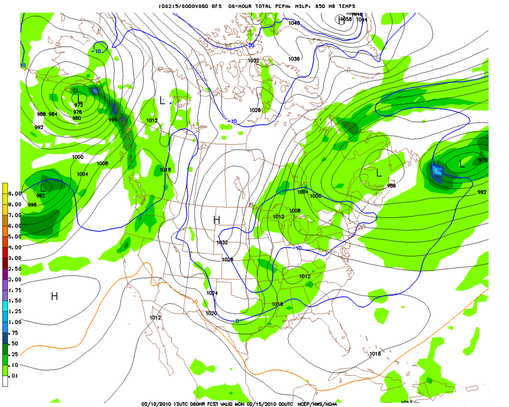
srainhoutx, this computer model depicts southeast Texas getting much in the way of heavy to very heavy sleet/snow during late next week.srainhoutx wrote:12Z GFS at 60 Hours...notice the 1058mb High in the Upper right of the chart...
-
wxman57

- Global Moderator
- Posts: 2621
- Joined: Thu Feb 04, 2010 5:34 am
- Location: Southwest Houston (Westbury)
- Contact:
Two things. First, that graphic you posted is from yesterday morning's model run, not today's. Today's is here:sleetstorm wrote:srainhoutx, this computer model depicts southeast Texas getting much in the way of heavy to very heavy sleet/snow during late next week.srainhoutx wrote:12Z GFS at 60 Hours...notice the 1058mb High in the Upper right of the chart...
http://i228.photobucket.com/albums/ee29 ... p_060l.gif
http://www.nco.ncep.noaa.gov/pmb/nwprod ... n_036m.gif
Second, as I keep trying to explain, the green precip areas DO NOT take place at the same time that the map is valid. The green shaded areas are precip that fell the PREVIOUS 6 hours. Let's say there's a strong cold front coming through at 6:30pm and it's preceded by a line of storms/showers. The rain moves in around 6pm and is over with by 7pm. The surface temperature at 7pm when the rain ends is 60 degrees.
Now you look at the MIDNIGHT chart and it shows that the surface temperature in Houston is down to 32F (0C on map). And it shows GREEN over us. Does that mean we're getting frozen precip? Nope. That green is the rain that fell between 6pm and 7pm when the temperature was well above freezing. The map doesn't say that precip is falling while the temperature is below freezing, just that SOME precip fell during the past 6 hours.
In the case of Sunday's front, the precip falls ahead of the front, not behind it. No frozen precip.
-
sleetstorm
- Posts: 651
- Joined: Thu Feb 04, 2010 12:33 pm
- Contact:
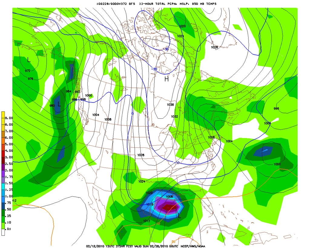
Is this model also from yesterday, wxman57?srainhoutx wrote:La La Land...
-
sleetstorm
- Posts: 651
- Joined: Thu Feb 04, 2010 12:33 pm
- Contact:
I am sorry for not completely understanding than model and taking it literal, wxman57.wxman57 wrote:Two things. First, that graphic you posted is from yesterday morning's model run, not today's. Today's is here:sleetstorm wrote:srainhoutx, this computer model depicts southeast Texas getting much in the way of heavy to very heavy sleet/snow during late next week.srainhoutx wrote:12Z GFS at 60 Hours...notice the 1058mb High in the Upper right of the chart...
http://i228.photobucket.com/albums/ee29 ... p_060l.gif
http://www.nco.ncep.noaa.gov/pmb/nwprod ... n_036m.gif
Second, as I keep trying to explain, the green precip areas DO NOT take place at the same time that the map is valid. The green shaded areas are precip that fell the PREVIOUS 6 hours. Let's say there's a strong cold front coming through at 6:30pm and it's preceded by a line of storms/showers. The rain moves in around 6pm and is over with by 7pm. The surface temperature at 7pm when the rain ends is 60 degrees.
Now you look at the MIDNIGHT chart and it shows that the surface temperature in Houston is down to 32F (0C on map). And it shows GREEN over us. Does that mean we're getting frozen precip? Nope. That green is the rain that fell between 6pm and 7pm when the temperature was well above freezing. The map doesn't say that precip is falling while the temperature is below freezing, just that SOME precip fell during the past 6 hours.
In the case of Sunday's front, the precip falls ahead of the front, not behind it. No frozen precip.
-
wxman57
- Global Moderator
- Posts: 2621
- Joined: Thu Feb 04, 2010 5:34 am
- Location: Southwest Houston (Westbury)
- Contact:
Yes, it's 24 hours old. Here's a link to the newest model guidance from a variety of models:sleetstorm wrote:Is this model also from yesterday, wxman57?srainhoutx wrote:La La Land...
http://i228.photobucket.com/albums/ee29 ... p_372l.gif
http://www.nco.ncep.noaa.gov/pmb/nwprod ... amer.shtml
-
wxman57
- Global Moderator
- Posts: 2621
- Joined: Thu Feb 04, 2010 5:34 am
- Location: Southwest Houston (Westbury)
- Contact:
Don't worry about it, sleetstorm. There are meteorologists who don't understand those charts. The trick to determining when the rain is actually occurring is to loop between the maps surrounding the one that shows possible winter precip. For example, if the 60hr map shows precip north of the "0C line", then loop between the 54, 60 and 66 hr map. See where that freezing line is on the 54 map and that's where it is at the START of the 6 hour precip that's on the 60 hr map. Look for green that exists in the same place (behind the 0C line) on the 54hr map as on the 60hr map. If you see some, then that precip actually does occur in the cold air.sleetstorm wrote:
I am sorry for not completely understanding than model and taking it literal, wxman57.

The Canadian may be picking up on what the European is showing...
And the Euro shows the moisture gown by the time the air gets cold enough for anything frozen in southeast Texas...

And the Euro shows the moisture gown by the time the air gets cold enough for anything frozen in southeast Texas...
-
txsnowmaker
- Posts: 632
- Joined: Wed Feb 03, 2010 4:07 pm
- Location: SW Houston (Galleria area)
- Contact:
If late next week doesn't bring us anything beyond cold rain, perhaps the potential reinforcing shots of colder air/stormy pattern that others have been discussing will do the trick in the week(s) that follow...
-
wxman57
- Global Moderator
- Posts: 2621
- Joined: Thu Feb 04, 2010 5:34 am
- Location: Southwest Houston (Westbury)
- Contact:
It looks like cross-Polar flow is setting up late in the week (ECMWF). That means the jet stream drives north into Siberia then south across the Pole, bringing some very cold air into northern Canada by next weekend. No more of this "recycled Canadian air" across the U.S., possibly. We could see some really cold air dip south into the U.S. the last week of February.txsnowmaker wrote:If late next week doesn't bring us anything beyond cold rain, perhaps the potential reinforcing shots of colder air/stormy pattern that others have been discussing will do the trick in the week(s) that follow...

Wxman,
Just how possibly cold are we talking for our part of SE Texas?
Just how possibly cold are we talking for our part of SE Texas?
-
sleetstorm
- Posts: 651
- Joined: Thu Feb 04, 2010 12:33 pm
- Contact:
Feasible lower thirties to twenties if not colder for daytime highs with feasible twenties to teens for nighttime lows?