
MARCH 2021

We could have a higher potential for severe weather and heavy rain next week as a trough dips down over the plains.
It's gonna be an angry spring
URGENT - IMMEDIATE BROADCAST REQUESTED
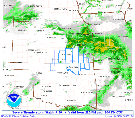
Tornado Watch Number 30
NWS Storm Prediction Center Norman OK
1155 AM CDT Wed Mar 17 2021
The NWS Storm Prediction Center has issued a
* Tornado Watch for portions of
Southwest Louisiana
Far southeast Texas
Coastal Waters
* Effective this Wednesday morning and evening from 1155 AM until
600 PM CDT.
* Primary threats include...
A few tornadoes likely with a couple intense tornadoes possible
Scattered damaging winds and isolated significant gusts to 75
mph possible
Scattered large hail and isolated very large hail events to 2.5
inches in diameter possible
SUMMARY...A few discrete supercells should develop along and just
ahead of the cold front pushing east from southeast Texas. The
greatest tornado threat is expected towards central Louisiana during
the late afternoon.
The tornado watch area is approximately along and 70 statute miles
east and west of a line from 30 miles northeast of Fort Polk LA to
50 miles south southwest of Lake Charles LA. For a complete
depiction of the watch see the associated watch outline update
(WOUS64 KWNS WOU0).
PRECAUTIONARY/PREPAREDNESS ACTIONS...
REMEMBER...A Tornado Watch means conditions are favorable for
tornadoes and severe thunderstorms in and close to the watch
area. Persons in these areas should be on the lookout for
threatening weather conditions and listen for later statements
and possible warnings.
&&
OTHER WATCH INFORMATION...CONTINUE...WW 26...WW 27...WW 28...WW
29...
AVIATION...Tornadoes and a few severe thunderstorms with hail
surface and aloft to 2.5 inches. Extreme turbulence and surface wind
gusts to 65 knots. A few cumulonimbi with maximum tops to 550. Mean
storm motion vector 24035.
...Grams

Mesoscale Discussion 0202
NWS Storm Prediction Center Norman OK
1202 PM CDT Wed Mar 17 2021
Areas affected...Portions of southeast Mississippi and southwest
Alabama
Concerning...Tornado Watch 29...
Valid 171702Z - 171800Z
The severe weather threat for Tornado Watch 29 continues.
SUMMARY...A strong tornado threat will increase from Wayne county,
Mississippi to Marengo and Wilcox counties in Alabama over the next
1-2 hours.
DISCUSSION...Shower activity through the morning has continued to
deepen and a strong storm has developed in Jones County, MS. This
storm has quickly exhibited low-level rotation which is indicative
of the favorable low-level shear profile in this region. SPC
mesoanalysis shows an area of 300 to 400 m2/s2 of 0-3km SRH in this
region which is a result of southeasterly surface winds in local
observations in this area and a 50 knot south-southwesterly
low-level jet around 1.5km to 2km sampled by the KMOB and KDGX VWP.
The ongoing storm in this region in addition to any subsequent
development could pose a significant tornado threat given the
aforementioned favorable low-level shear profile and STP values
around 2 to 3.
..Bentley/Grams.. 03/17/2021
...Please see www.spc.noaa.gov for graphic product...
ATTN...WFO...BMX...MOB...JAN...
LAT...LON 31808915 32228864 32538795 32418740 32128729 31668749
31588799 31458874 31478910 31538924 31808915


The WMO (World Meteorological Organization) Hurricane Committee has retired Dorian from 2019 and Laura, Eta and Iota (2020) from the rotating list of Atlantic names due to the damage and death associated with them.
Also interesting of note in the article, "It also decided that the Greek alphabet will not be used in future because it creates a distraction from the communication of hazard and storm warnings and is potentially confusing."
More here: https://public.wmo.int/en/media/press-r ... e-of-greek
Also interesting of note in the article, "It also decided that the Greek alphabet will not be used in future because it creates a distraction from the communication of hazard and storm warnings and is potentially confusing."
More here: https://public.wmo.int/en/media/press-r ... e-of-greek
Blake
Boomer Sooner
Boomer Sooner

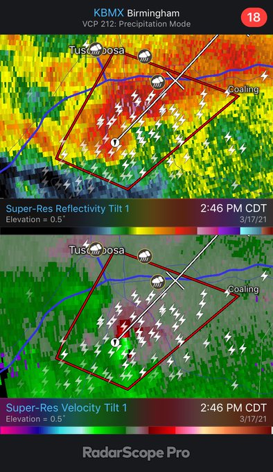
Mesoscale Discussion 0209
NWS Storm Prediction Center Norman OK
0224 PM CDT Wed Mar 17 2021
Areas affected...Central AL
Concerning...Tornado Watch 29...33...
Valid 171924Z - 172100Z
The severe weather threat for Tornado Watch 29, 33 continues.
SUMMARY...A corridor more favorable for the development of strong
tornadoes may be evolving across central AL.
DISCUSSION...Radar imagery from BMX, GWX, and MOB continues to show
a cluster of supercells over west-central AL. The downstream air
mass is characterized by temperatures in the low/mid 70s and
dewpoints in the upper 60s. As noted in the recent BMX sounding,
this air mass is less buoyant than farther west (along the central
MS/AL border) where this cluster initially developed. However, in
contrast to the slightly less favorable thermodynamics, surface
winds here are more southeasterly, veering to southerly in the
low-levels, and then southwesterly farther aloft. This is resulting
in considerable low-level vertical shear. Recent VAD profile from
BMX sampled 350+ m2/s2 of 0-1 km storm-relative helicity. Given the
already organized character of these storms, potential exists for
the development of strong tornadoes if a more discrete nature can be
maintained.
..Mosier.. 03/17/2021
...Please see www.spc.noaa.gov for graphic product...
ATTN...WFO...BMX...MOB...
Radar scan just south/southeast of Tuscaloosa...

Mesoscale Discussion 0210
NWS Storm Prediction Center Norman OK
0256 PM CDT Wed Mar 17 2021
Areas affected...Northeast Louisiana...southeast Arkansas and much
of Mississippi.
Concerning...Tornado Watch 32...
Valid 171956Z - 172130Z
The severe weather threat for Tornado Watch 32 continues.
SUMMARY...The tornado threat is expected to increase late this
afternoon/evening.
DISCUSSION...Most of Mississippi is in a relative lull for
convective coverage/intensity with more intense convection to the
east with the stronger low-level jet and to the west near the
surface trough. Within this area, significant clearing has allowed
temperatures to warm into the low 80s with dewpoints in the upper
60s yielding MLCAPE of 1500 to 2000 J/kg per SPC mesoanalysis. This
strong surface heating has led to deep boundary layer mixing (as
evident on the 18Z JAN RAOB) and as a result, surface flow has
veered southwesterly across much of Mississippi which has reduced
low-level directional shear significantly. However, despite this
veered low-level flow, a widespread and potentially intense tornado
threat is still expected late this afternoon/evening as the surface
trough approaches.
Low-level flow in proximity to this surface trough has started to
back across southeast Arkansas and Louisiana. Expect this trend to
continue as the boundary tightens in response to the ejecting upper
trough. Evidence of this ejecting trough and the corresponding
increase to the flow field can be seen on the KLCH VWP where 1km
flow has strengthened by 20 kts (to near 60 knots) within the last
hour. Expect this stronger low-level jet to overspread much of the
warm sector by 22-00Z which should elongate low-level hodographs
substantially.
Expect multiple supercells to develop along this surface boundary in
the next few hours and track northeastward through the late
afternoon and into the evening hours. In response to the
aforementioned instability and strengthening low-level shear, the
12Z HREF shows widespread 4+ STP across much of Mississippi this
afternoon/evening with some areas in excess of 6. This environment
will support the potential for intense/long-track tornadoes through
the late afternoon and evening hours.
..Bentley.. 03/17/2021
...Please see www.spc.noaa.gov for graphic product...
ATTN...WFO...HUN...MEG...JAN...LIX...LZK...LCH...SHV...
-
TexasBreeze
- Posts: 942
- Joined: Sun Sep 26, 2010 4:46 pm
- Location: NW Houston, TX
- Contact:
Dexter replaces Dorian and Leah replaces Laura.Belmer wrote: ↑Wed Mar 17, 2021 2:20 pm The WMO (World Meteorological Organization) Hurricane Committee has retired Dorian from 2019 and Laura, Eta and Iota (2020) from the rotating list of Atlantic names due to the damage and death associated with them.
Also interesting of note in the article, "It also decided that the Greek alphabet will not be used in future because it creates a distraction from the communication of hazard and storm warnings and is potentially confusing."
More here: https://public.wmo.int/en/media/press-r ... e-of-greek
Alternative lists of names instead of Greeks for Atlantic and Pacific....
https://public.wmo.int/en/media/news/su ... names-raiv
Looking at the models today for right now I would be more concerned with heavy rain, than severe weather for us next week as instability may be lacking.But of course that could change.
Mississippi and Alabama getting walloped already and they are saying it's going to be much worse this evening.

It looks like that storm turned into a pretty good squall. I thought that pretty much ended the Tornado threat once the squall hits. Is something coming in behind it for them?
Doesn't eliminate the tornado threat, but reduces it. Can still get tornadoes embedded within the squall line out ahead of it. Nothing else behind the main line will redevelop as that is the frontal boundary. Focus for tornadoes overnight will be into eastern AL, GA and then the Carolina's tomorrow.
Blake
Boomer Sooner
Boomer Sooner

Serious advection this afternoon and tonight up in BCS.
25WNW 35G
About 1/2 inch of rain this morning.
Looks like dry, sunny Chamber of Commerce weather for the next 3 days
25WNW 35G
About 1/2 inch of rain this morning.
Looks like dry, sunny Chamber of Commerce weather for the next 3 days
There’s a chance that most of the rain for next week could be north and east of southeast TX once again.
Chamber of Commerce weekend dialed up.
We need to keep an eye on next week as the GFS shows a possible multi day tornado setup locally with moderate to high CAPE,as disturbances ride a stalled frontal boundary.Especially as the main surface low moves inland over the area with a warm front.Not expecting any widespread flooding right now but locally heavy rain definitely cannot be ruled out either. Any stormy weather we get next week will ultimately depend on the location of the stalled boundary and track of the main upper level trough.
-
- Information
-
Who is online
Users browsing this forum: Ahrefs [Bot], Bing [Bot], Semrush [Bot] and 96 guests