
MARCH 2021
The 12z Euro finally has a decent system coming through here next Tuesday but that’s 9 days out.
Quite muggy and warm right now. Should be good thunderstorm fuel if anything gets going this week.
Major tornado outbreak tomorrow for the Dixie Alley. Could be looking at a historical day.

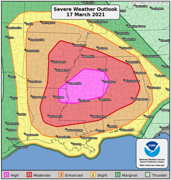
Day 1 Convective Outlook
NWS Storm Prediction Center Norman OK
1252 AM CDT Wed Mar 17 2021
Valid 171200Z - 181200Z
...THERE IS A HIGH RISK OF SEVERE THUNDERSTORMS FROM NORTHEAST
LOUISIANA ACROSS NORTHERN MISSISSIPPI INTO NORTHWEST ALABAMA...
...SUMMARY...
A regional outbreak of severe storms is expected today and tonight
across portions of the lower Mississippi Valley into Alabama.
Widespread severe storms capable of producing tornadoes (several of
which may be intense), very large hail and intense damaging wind
gusts are expected. More than one round of severe storms are
possible across parts of Mississippi into Alabama during the
afternoon into the overnight hours.
...Lower Mississippi Valley to Alabama...
Early-morning water-vapor imagery depicts a well-defined upper low
over central NM moving east toward the TX Panhandle. This feature
will eject across OK into the Ozark Plateau by the end of the
period. Intense large-scale forcing for ascent is currently
spreading across the southern High Plains region where deep
convection is currently expanding in areal coverage along the dry
line/Pacific front as it encounters western edge of moisture plume.
This boundary will remain active leading into the start of the day1
period.
Strongly diffluent flow aloft will overspread the lower MS
Valley/central Gulf States during the day as 80kt+ 500mb flow
overspreads increasingly moist/buoyant warm sector. Latest model
guidance suggests several LLJ segments will increase ahead of the
trough, each likely modulating bouts of organized severe
thunderstorm clusters/supercells. The primary synoptic low is
forecast to track across northeastern OK into southern MO.
Significant elevated convection will be noted north of the warm
front but ample surface-based buoyancy/shear south of the front
should prove favorable for supercells as one LLJ segment focuses
across AR into southeast MO ahead of this feature. At the same time,
a secondary LLJ will strengthen across MS during the day and become
the primary LLJ into the overnight hours over northwestern AL/middle
TN. This secondary LLJ appears to be responding to a mid-level speed
max that will translate across south-central TX into southern LA
during the late evening hours.
Of particular interest is the boundary-layer moisture that is now
present along the Gulf Coast where lower 70s surface dew points are
observed. This air mass will advance north during the day and
diurnal heating will allow moderate instability to develop along a
corridor from southern LA through central MS into western AL where
SBCAPE should be on the order of 2500 J/kg. While the primary 500mb
speed max will likely maintain convection along the surging Pacific
front over southeast TX, an uncapped, buoyant air mass downstream
over MS/AL should prove favorable for discrete supercell development
ahead of the primary short wave. Forecast soundings across the HIGH
Risk exhibit profiles favorable for strong, long-track tornadoes,
and this is especially true from northeast LA through northern MS
into northwest AL.
..Darrow/Lyons.. 03/17/2021

Day 2 Convective Outlook
NWS Storm Prediction Center Norman OK
0108 AM CDT Wed Mar 17 2021
Valid 181200Z - 191200Z
...THERE IS A MODERATE RISK OF SEVERE THUNDERSTORMS FROM CENTRAL AND
EASTERN GEORGIA NORTHEASTWARD ACROSS PARTS OF CENTRAL AND EASTERN
NORTH CAROLINA...
...SUMMARY...
A widespread/substantial severe weather event is expected to
continue into Thursday from southern Virginia southward into
Florida, and westward into portions of eastern Kentucky/eastern
Tennessee. Along with potential for widespread damaging winds and
hail, several tornadoes -- a few of them likely to be strong -- are
anticipated.
...Synopsis...
An upper low initially forecast over the Ozarks area is expected to
shift steadily eastward through the period, reaching the Mid South
by evening and then crossing the Appalachians and evolving into a
more open wave overnight. Meanwhile in the west, an eastern Pacific
upper low/trough should approach the West Coast overnight.
At the surface, a low initially progged over the southern Illinois
area will cross the Ohio Valley through the day. By evening, the
low should reside in the central Appalachians area, and then is
expected to elongate across the Mid Atlantic region overnight as
weak offshore low development commences. A cold front trailing from
the low -- bisecting the Mid South and extending south to the
western Florida Panhandle -- should clear the crest of the
Appalachians during the early evening, before continuing eastward to
move off the East Coast overnight. Meanwhile, a remnant damming
front will shift quickly northward as a warm front across the
Atlantic Coast states, allowing a warm sector to spread northward
into Virginia ahead of the advancing low.
...Eastern KY/TN east to the Chesapeake Bay, and south to FL...
Showers and thunderstorms are forecast to be ongoing in an elongated
zone of warm advection from Missouri east across the Ohio Valley
states and into the Mid Atlantic region, and more significantly --
from eastern Tennessee and possibly eastern Kentucky, southward
across western Georgia, southeastern Alabama, and the Florida
Panhandle. Ongoing/all-hazards severe risk is expected to accompany
the convection -- primarily across the northern/western Georgia
vicinity.
With time, continued northward moistening/theta-e advection ahead of
the approaching system will result in a broad warm sector east of
the Appalachian crest, and secondarily -- across parts of eastern
Kentucky and southern Ohio into West Virginia/western Virginia.
Though heating may be tempered into the afternoon in many areas due
to downstream cloud debris from ongoing convection, around 1000 J/kg
mixed-layer CAPE should become widespread across the warm sector.
The increasingly moist/unstable environment will support a
continuation of the ongoing storms within a loose band ahead of the
cold front, which will spread across Georgia and the Carolinas, and
eventually southern Virginia, with some potential for
isolated/cellular development ahead of this convective band. Cells
may also develop in the wake of an initial convective band northward
into western North Carolina, while storms also develop into the
afternoon west of the mountains into southern Ohio/western
Kentucky/west Virginia. The storms west of the mountains will
likely become locally severe, with hail and damaging winds the
primary risk, though a tornado or two would be possible.
Farther south and east -- into eastern Georgia and the Carolinas,
and spreading north into parts of southern Virginia, very strong
flow aloft, veering -- and increasing substantially in magnitude
with height through the lower troposphere -- will result in shear
quite favorable for supercells. Along with hail potential, the more
substantial risk will be from widespread damaging winds, as well as
tornadoes -- including possibility for a few strong/significant
tornadoes during the afternoon and into the early evening. Threat
will gradually taper from west to east, as the system shifts
eastward and the cold front eventually moves offshore.
..Goss.. 03/17/2021
Public Severe Weather Outlook (PWO)
Note: During early morning hours (approximately 6am Central time), the SPC will produce a multimedia briefing MP4 file shortly after the PWO issuance. Please check back momentarily for a link to this MP4 file on this page. Please note the briefing may be out of date 5 hours after its issuance and there will be no subsequent updates
PUBLIC SEVERE WEATHER OUTLOOK
NWS STORM PREDICTION CENTER NORMAN OK
0451 AM CDT WED MAR 17 2021
...Outbreak of tornadoes and severe thunderstorms expected over parts of the The lower Mississippi Valley into the Southeast later today and tonight...
* LOCATIONS...
Much of Mississippi
Eastern and northern Louisiana
Much of Alabama
Much of Arkansas
Southwest Tennessee
Extreme southern Missouri
* HAZARDS...
Numerous tornadoes, several intense and long track Scattered damaging winds, some hurricane force Scattered large hail, some baseball size
* SUMMARY...
A regional outbreak of severe storms is expected today and tonight across portions of the lower Mississippi Valley into Alabama. Widespread severe storms capable of producing tornadoes (several of which may be intense), very large hail and intense damaging wind gusts are expected. More than one round of severe storms are possible across parts of Mississippi into Alabama during the afternoon into the overnight hours.
Preparedness actions...
Review your severe weather safety procedures for the possibility of dangerous weather today. Stay tuned to NOAA Weather Radio,
weather.gov, or other media for watches and warnings. A tornado watch means that conditions are favorable for tornadoes to form
during the next several hours. If a tornado warning is issued for your area, move to a place of safety, ideally in a basement or
interior room on the lowest floor of a sturdy building.
&&
..Thompson.. 03/17/2021
Dixie Alley seems worse than Tornado Alley lately.
tools for today (or any day)
https://weather.im/iembot/ - choose which weather room(s) to monitor
https://mrms.nssl.noaa.gov/qvs/product_viewer/
https://twitter.com/NWStornado
https://twitter.com/NWSSevereTstorm
https://twitter.com/iembot_spc
https://twitter.com/iembot_wpc
https://weather.im/iembot/ - choose which weather room(s) to monitor
https://mrms.nssl.noaa.gov/qvs/product_viewer/
https://twitter.com/NWStornado
https://twitter.com/NWSSevereTstorm
https://twitter.com/iembot_spc
https://twitter.com/iembot_wpc
-
tireman4

- Global Moderator

- Posts: 4488
- Joined: Wed Feb 03, 2010 9:24 pm
- Location: Humble, Texas
- Contact:
Meanwhile, back in our area...
Special Weather Statement
Special Weather Statement
National Weather Service Houston/Galveston TX
1039 AM CDT Wed Mar 17 2021
TXZ213-227-237-171615-
Inland Brazoria TX-Inland Harris TX-Fort Bend TX-
1039 AM CDT Wed Mar 17 2021
...SIGNIFICANT WEATHER ADVISORY FOR CENTRAL FORT BEND...NORTHERN
BRAZORIA AND SOUTH CENTRAL HARRIS COUNTIES UNTIL 1115 AM CDT...
At 1038 AM CDT, Doppler radar was tracking a strong thunderstorm over
Pleak, or near Rosenberg, moving northeast at 35 mph.
Pea size hail and winds in excess of 40 mph will be possible with
this storm.
Locations impacted include...
Pearland, Sugar Land, Missouri City, Rosenberg, Stafford, Bellaire,
West University Place, Richmond, northwestern Manvel, Hunters Creek
Village, Bunker Hill Village, Piney Point Village, Midtown Houston,
Greenway / Upper Kirby Area, Fresno, Neartown / Montrose, Town West,
Pecan Grove, Memorial Park and University Place.
PRECAUTIONARY/PREPAREDNESS ACTIONS...
Cloud to ground lightning is occurring with this storm.
Lightning can strike 10 miles away from a thunderstorm. Seek a safe
shelter inside a building or vehicle.
&&
LAT...LON 2939 9580 2952 9592 2982 9541 2953 9528
TIME...MOT...LOC 1538Z 245DEG 32KT 2951 9577
$$
Special Weather Statement
Special Weather Statement
National Weather Service Houston/Galveston TX
1030 AM CDT Wed Mar 17 2021
TXZ212-213-227-171615-
Waller TX-Inland Harris TX-Fort Bend TX-
1030 AM CDT Wed Mar 17 2021
...SPECIAL WEATHER STATEMENT...
At 1030 AM CDT, Doppler radar was tracking a strong thunderstorm near
Orchard, or near Rosenberg, moving northeast at 50 mph.
Pea size hail and winds in excess of 30 mph will be possible with
this storm.
Locations impacted include...
Sugar Land, Rosenberg, Stafford, Bellaire, West University Place,
Katy, Richmond, Jersey Village, Hunters Creek Village, Bunker Hill
Village, Piney Point Village, Greenway / Upper Kirby Area, Spring
Branch North, Greater Heights, Mission Bend, Neartown / Montrose,
Town West, Near Northside Houston, Pecan Grove and Memorial Park.
PRECAUTIONARY/PREPAREDNESS ACTIONS...
Cloud to ground lightning is occurring with this storm.
Lightning can strike 10 miles away from a thunderstorm. Seek a safe
shelter inside a building or vehicle.
&&
LAT...LON 2943 9584 2955 9604 3004 9576 2979 9533
TIME...MOT...LOC 1530Z 222DEG 42KT 2959 9589
$$
Special Weather Statement
Special Weather Statement
National Weather Service Houston/Galveston TX
1039 AM CDT Wed Mar 17 2021
TXZ213-227-237-171615-
Inland Brazoria TX-Inland Harris TX-Fort Bend TX-
1039 AM CDT Wed Mar 17 2021
...SIGNIFICANT WEATHER ADVISORY FOR CENTRAL FORT BEND...NORTHERN
BRAZORIA AND SOUTH CENTRAL HARRIS COUNTIES UNTIL 1115 AM CDT...
At 1038 AM CDT, Doppler radar was tracking a strong thunderstorm over
Pleak, or near Rosenberg, moving northeast at 35 mph.
Pea size hail and winds in excess of 40 mph will be possible with
this storm.
Locations impacted include...
Pearland, Sugar Land, Missouri City, Rosenberg, Stafford, Bellaire,
West University Place, Richmond, northwestern Manvel, Hunters Creek
Village, Bunker Hill Village, Piney Point Village, Midtown Houston,
Greenway / Upper Kirby Area, Fresno, Neartown / Montrose, Town West,
Pecan Grove, Memorial Park and University Place.
PRECAUTIONARY/PREPAREDNESS ACTIONS...
Cloud to ground lightning is occurring with this storm.
Lightning can strike 10 miles away from a thunderstorm. Seek a safe
shelter inside a building or vehicle.
&&
LAT...LON 2939 9580 2952 9592 2982 9541 2953 9528
TIME...MOT...LOC 1538Z 245DEG 32KT 2951 9577
$$
Special Weather Statement
Special Weather Statement
National Weather Service Houston/Galveston TX
1030 AM CDT Wed Mar 17 2021
TXZ212-213-227-171615-
Waller TX-Inland Harris TX-Fort Bend TX-
1030 AM CDT Wed Mar 17 2021
...SPECIAL WEATHER STATEMENT...
At 1030 AM CDT, Doppler radar was tracking a strong thunderstorm near
Orchard, or near Rosenberg, moving northeast at 50 mph.
Pea size hail and winds in excess of 30 mph will be possible with
this storm.
Locations impacted include...
Sugar Land, Rosenberg, Stafford, Bellaire, West University Place,
Katy, Richmond, Jersey Village, Hunters Creek Village, Bunker Hill
Village, Piney Point Village, Greenway / Upper Kirby Area, Spring
Branch North, Greater Heights, Mission Bend, Neartown / Montrose,
Town West, Near Northside Houston, Pecan Grove and Memorial Park.
PRECAUTIONARY/PREPAREDNESS ACTIONS...
Cloud to ground lightning is occurring with this storm.
Lightning can strike 10 miles away from a thunderstorm. Seek a safe
shelter inside a building or vehicle.
&&
LAT...LON 2943 9584 2955 9604 3004 9576 2979 9533
TIME...MOT...LOC 1530Z 222DEG 42KT 2959 9589
$$

Mesoscale Discussion 0200
NWS Storm Prediction Center Norman OK
1056 AM CDT Wed Mar 17 2021
Areas affected...Central MS...Central AL
Concerning...Severe potential...Tornado Watch likely
Valid 171556Z - 171800Z
Probability of Watch Issuance...95 percent
SUMMARY...The environment is becoming increasingly favorable for
tornadic supercells and a PDS tornado watch will likely be needed
within the next hour or two.
DISCUSSION...Regional radar and satellite imagery continues to show
deepening convection within the broad and robust warm-air advection
regime across much of MS and AL. Some modest clearing occurred
briefly ahead of the leading showers over MS and temperatures across
much of central and southern MS are now in the mid 70s. Slightly
cooler surface temperatures exist across central/southern AL.
Dewpoints exhibit a similar trend, with upper 60s/low 70s across
much of central/southern MS and mid to upper 60s across
central/southern AL. These thermodynamic conditions have eroded much
of the convective inhibition across the region, although forecast
soundings do suggests some minimal (i.e. MLCIN of -25 J/kg or more)
likely remains in place at the top of the boundary layer. Continued
moistening of the low-level profile coupled with slight cooling
aloft should result in a removal of all convective inhibition.
In addition to improving thermodynamics, the low-level wind fields
continue to increase. Recent VAD profiles from LIX and DGX show 50
kts within the 1-2 km layer. Latest VAD from DGX also sampled 0-3 km
storm-relative helicity over 350 m2/s2. These strengthening
low-level winds are expected to persist while gradually spreading
northward/northeastward into more of northern AL. Deep-layer
vertical shear is already in place over the region, with 0-6 km bulk
shear currently 50 kt over central MS/AL, increasing to 70 kt over
northern MS/AL.
In all, the overall environment is expected to becoming increasingly
favorable for discrete supercells capable of all severe hazards,
including intense tornadoes. These initial storms are forecast to
develop within the 17-19Z time frame. A prolonged threat for
tornadoes is anticipated across the region, with conditions
remaining favorable well into the evening.
..Mosier/Grams.. 03/17/2021
...Please see www.spc.noaa.gov for graphic product...
ATTN...WFO...BMX...HUN...MOB...MEG...JAN...
LAT...LON 32929083 34038838 33898610 32588612 31368837 31479076
32929083
BULLETIN - IMMEDIATE BROADCAST REQUESTED
Severe Thunderstorm Warning
National Weather Service Houston/Galveston TX
1111 AM CDT Wed Mar 17 2021
The National Weather Service in League City has issued a
* Severe Thunderstorm Warning for...
Northeastern Fort Bend County in southeastern Texas...
Southeastern Montgomery County in southeastern Texas...
Northwestern Chambers County in southeastern Texas...
Southwestern Liberty County in southeastern Texas...
Central Harris County in southeastern Texas...
* Until 1145 AM CDT.
* At 1110 AM CDT, a severe thunderstorm was located over Afton Oaks /
River Oaks Area, moving northeast at 50 mph.
HAZARD...Quarter size hail.
SOURCE...Radar indicated.
IMPACT...Damage to vehicles is expected.
* Locations impacted include...
Northwestern Pasadena, northern Baytown, northern Missouri City,
Deer Park, Bellaire, Humble, West University Place, Galena Park,
Jacinto City, Jersey Village, Dayton, Hunters Creek Village, Bunker
Hill Village, Piney Point Village, Cloverleaf, Downtown Houston,
Greenway / Upper Kirby Area, Kingwood, Spring Branch North and
Second Ward.
PRECAUTIONARY/PREPAREDNESS ACTIONS...
For your protection move to an interior room on the lowest floor of a
building.
Cloud to ground lightning is occurring with this storm. Move indoors
immediately. Lightning is one of nature's leading killers. Remember,
if you can hear thunder, you are close enough to be struck by
lightning.
&&
LAT...LON 2959 9547 2979 9567 3024 9509 2988 9473
TIME...MOT...LOC 1610Z 234DEG 49KT 2975 9543
HAIL...1.00IN
WIND...<50MPH
$$
TJC

First severe thunderstorm of the season. The rain is very heavy right now.
- Attachments
-
- hgqx.png (11.81 KiB) Viewed 3746 times

Mesoscale Discussion 0201
NWS Storm Prediction Center Norman OK
1135 AM CDT Wed Mar 17 2021
Areas affected...Southeast Texas and western Louisiana
Concerning...Tornado Watch 28...
Valid 171635Z - 171800Z
The severe weather threat for Tornado Watch 28 continues.
SUMMARY...A new watch may be needed south of Watch 28 across
southeast Texas and western Louisiana.
DISCUSSION...The well-developed squall line has started to break up
and weaken across northern Louisiana and southern Arkansas where the
line has moved ahead of the front. However, stronger storms continue
farther south where storms are closer to the surface front in an
area of greater low-level convergence. These storms extend into
southeast Texas where no watch is currently in effect and thus a new
watch may need to be issued soon. The current tornado threat is
somewhat lower with southern extent as low-level wind fields are
quite unidirecitonal. However, the low-level jet is expected to
strengthen over the next few hours which may increase the tornado
threat. Damaging winds and large hail will be the primary threat in
the near term given around 1000 to 1500 J/kg MLCAPE and effective
shear around 50 knots.
..Bentley/Grams.. 03/17/2021
...Please see www.spc.noaa.gov for graphic product...
ATTN...WFO...LCH...SHV...HGX...
LAT...LON 32629374 32689292 32349220 31719225 30239289 29739311
29669383 29369449 28979509 28869532 29079582 29729573
32629374
URGENT - IMMEDIATE BROADCAST REQUESTED
Tornado Watch Number 29
NWS Storm Prediction Center Norman OK
1135 AM CDT Wed Mar 17 2021
The NWS Storm Prediction Center has issued a
* Tornado Watch for portions of
Western and central Alabama
Central to eastern Mississippi
* Effective this Wednesday morning and evening from 1135 AM until
700 PM CDT.
...THIS IS A PARTICULARLY DANGEROUS SITUATION...
* Primary threats include...
Numerous tornadoes expected with a few intense tornadoes likely
Scattered damaging winds and isolated significant gusts to 80
mph likely
Scattered large hail and isolated very large hail events to 3
inches in diameter likely
SUMMARY...Numerous discrete supercells are expected to develop this
afternoon capable of producing strong to intense tornadoes.
The tornado watch area is approximately along and 80 statute miles
east and west of a line from 70 miles northwest of Gadsden AL to 35
miles southeast of Pine Belt MS. For a complete depiction of the
watch see the associated watch outline update (WOUS64 KWNS WOU9).
PRECAUTIONARY/PREPAREDNESS ACTIONS...
REMEMBER...A Tornado Watch means conditions are favorable for
tornadoes and severe thunderstorms in and close to the watch
area. Persons in these areas should be on the lookout for
threatening weather conditions and listen for later statements
and possible warnings.
&&
OTHER WATCH INFORMATION...CONTINUE...WW 26...WW 27...WW 28...
AVIATION...Tornadoes and a few severe thunderstorms with hail
surface and aloft to 3 inches. Extreme turbulence and surface wind
gusts to 70 knots. A few cumulonimbi with maximum tops to 500. Mean
storm motion vector 24030.
...Grams

It was a dud here. Only 0.02”