

May 2021:
Another pretty wet stretch coming up:
-
Stratton20
- Posts: 4248
- Joined: Tue Feb 09, 2021 11:35 pm
- Location: College Station, Texas
- Contact:
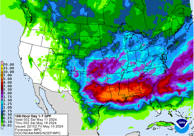
Noaa calls for a well above normal precipitation period while the WPC only has southeast Texas picking up .25 to maybe 1 inch for the entire week


I’m guessing today’s rain chances fizzled out.

-
Stratton20
- Posts: 4248
- Joined: Tue Feb 09, 2021 11:35 pm
- Location: College Station, Texas
- Contact:
Boooo I want that ridge to stay away! Hope next week rain chances go back up, as someone who lived in the middle east for 2 years, ai cant stand dry weather, rainy weather is where its at!
 Hope next week rain chances go back up, as someone who lived in the middle east for 2 years, ai cant stand dry weather, rainy weather is where its at!
That’s a 6 to 10 day forecast for the dates of June 4th through June 8th from the CPC. The WPC QPF forecast is for the next 7 days and often times the WPC is way off on their predictions and it tends to actually rain quite a bit more than what it’s actually saying. They’re usually very conservative.Stratton20 wrote: ↑Sat May 29, 2021 2:55 pm Noaa calls for a well above normal precipitation period while the WPC only has southeast Texas picking up .25 to maybe 1 inch for the entire week
Couple of storms near Beaumont, moving SW.
Should die out before Houston.
Should die out before Houston.
The 0z Euro came in very wet showing 4-6”.
-
Stratton20
- Posts: 4248
- Joined: Tue Feb 09, 2021 11:35 pm
- Location: College Station, Texas
- Contact:
Strong signal in the GFS for potential tropical development in the gulf around the 9th or 10th, I know its far out but some people are starting to mention it, definitely could happen as conditions are slowly becoming more conducive for development
Those rain chances that were originally predicted for Saturday actually came late Friday night so no they didn’t really fizzle out, they just came earlier than predicted.
[/quote]
I was thinking the same.
The WPC is slowly coming around:
The Euro is really wet too.
So is the CPC:


Also, check out the cooler temps:


And if you combine all that with the warming SST’s in the Gulf and the GFS hinting at development, anything that does develop could potentially head towards the western Gulf.
The Euro is really wet too.
So is the CPC:
Also, check out the cooler temps:
And if you combine all that with the warming SST’s in the Gulf and the GFS hinting at development, anything that does develop could potentially head towards the western Gulf.
Last edited by Cpv17 on Mon May 31, 2021 10:17 am, edited 2 times in total.
-
Stratton20
- Posts: 4248
- Joined: Tue Feb 09, 2021 11:35 pm
- Location: College Station, Texas
- Contact:
Yeah we definitely could be looking at some tropical development within the next 7-10 days, and definitely concerned about a Texas Impact should anything form. Ridging in the east and Northeast will pretty much send any sort of tropical system our way

^Going to enjoy this while it lasts. EVery week of cool(ish) and wet brings us one week closer to football season...and eventually something that mimics Fall for 2-3 weeks. 
-
srainhoutx

- Site Admin

- Posts: 19616
- Joined: Tue Feb 02, 2010 2:32 pm
- Location: Maggie Valley, NC
- Contact:
NWS Houston
@NWSHouston
Map showing Category 4 Hurricanes within 120 miles of Galveston. Laura (2020) joins select group: Galveston 1900 and 1915 hurricanes, 1932 storm, and Carla (1961).
- Attachments
-
Carla/Alicia/Jerry(In The Eye)/Michelle/Charley/Ivan/Dennis/Katrina/Rita/Wilma/Humberto/Ike/Harvey
Member: National Weather Association
Facebook.com/Weather Infinity
Twitter @WeatherInfinity
Member: National Weather Association
Facebook.com/Weather Infinity
Twitter @WeatherInfinity
-
Stratton20
- Posts: 4248
- Joined: Tue Feb 09, 2021 11:35 pm
- Location: College Station, Texas
- Contact:
Interesting map
Didn’t CPV call this possible storm a few days ago?
-
Stratton20
- Posts: 4248
- Joined: Tue Feb 09, 2021 11:35 pm
- Location: College Station, Texas
- Contact:
Huh?
Huh what! You know damn well he did.