Page 4 of 39
Re: May 2021
Posted: Tue May 04, 2021 12:38 pm
by jasons2k
Cromagnum wrote: ↑Tue May 04, 2021 12:18 pm
As soon as the cells get to the LA state line the storms are blowing up.
Right? And yes, like clockwork, the cell by IAH busts through as soon as the line passed.
Re: May 2021
Posted: Tue May 04, 2021 12:48 pm
by txbear
Think the HRRR got the storms right in general, location was off though with the biggest cluster going north and east...sound familiar? Models are models, not crystal balls.
Cap must be pretty stout south and west considering the dynamics in play. A little more in rain to add to the "reserve tank" in preparation for summer would've been nice.
Re: May 2021
Posted: Tue May 04, 2021 1:05 pm
by Cpv17
txbear wrote: ↑Tue May 04, 2021 12:48 pm
Think the HRRR got the storms right in general, location was off though with the biggest cluster going north and east...sound familiar? Models are models, not crystal balls.
Cap must be pretty stout south and west considering the dynamics in play. A little more in rain to add to the "reserve tank" in preparation for summer would've been nice.
Maybe next week. Rest of this week looks dry.
Re: May 2021
Posted: Tue May 04, 2021 2:39 pm
by don
Models are showing a stormy pattern again next week as a slow moving front stalls near the coast.With disturbances moving over the state in the northwest flow aloft.We'll see if the trends continue...
Re: May 2021
Posted: Tue May 04, 2021 3:15 pm
by jasons2k
Oh it’s only 10 degrees warmer than forecast....nothing to see here....
Re: May 2021
Posted: Tue May 04, 2021 3:30 pm
by djmike
A whole lot of nothing for me in Beaumont. Knew it. Well 2 maaaaaybe 3 drops.
Re: May 2021
Posted: Tue May 04, 2021 5:31 pm
by Cpv17
don wrote: ↑Tue May 04, 2021 2:39 pm
Models are showing a stormy pattern again next week as a slow moving front stalls near the coast.With disturbances moving over the state in the northwest flow aloft.We'll see if the trends continue...
The CPC is seeing this as well:


Definitely looks like a wet pattern could be in the works.
Re: May 2021
Posted: Wed May 05, 2021 6:59 am
by Cromagnum
Feels really nice outside this morning.
Re: May 2021
Posted: Wed May 05, 2021 10:42 am
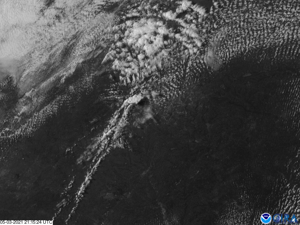
by unome
Texas' dry-line weather on May 3rd made the NOAA / NESDIS Image of the Day
with a great explaination of dry-line storm formation
https://twitter.com/NOAASatellites/stat ... 2673552389
https://www.nesdis.noaa.gov/content/goe ... s-dry-line
Re: May 2021
Posted: Fri May 07, 2021 10:28 pm
by DoctorMu
If it feels hotter and in the last decade WHEN it (finally) rains it pours (like Harvey and Memorial Day? events), then you're right!
https://www.chron.com/weather/article/g ... 6a35e392f3
Re: May 2021
Posted: Sat May 08, 2021 10:18 am
by Iceresistance
There is a marginal risk of Storms in Western Texas & Western Oklahoma for storms that will try to go up, but the Cap is too strong, it looks like that Kansas will have the first May Severe Weather event, the STPC (Significant Tornado Parameter Composite) is higher up there & into Missouri, but the STPC is too low (And the Cap) across Oklahoma & Texas will only give out the Marginal risk across Texas & Oklahoma, the uncertainty is just too high! First Post

Re: May 2021
Posted: Sat May 08, 2021 2:15 pm
by Cpv17
Could have a wet next few days ahead. Both the GFS and Euro are showing potential for 2-4” widespread.
Re: May 2021
Posted: Sun May 09, 2021 2:45 am
by Cpv17
Wow on the latest Euro run

definitely going to open some eyes.
Re: May 2021
Posted: Sun May 09, 2021 6:28 am
by Iceresistance
Enhanced risk from East-Central Texas (Lufkin) to Memphis, TN at the Mississippi . . .

Re: May 2021
Posted: Sun May 09, 2021 12:01 pm
by Cromagnum
Post it please? I'm only seeing 10-20% until Tuesday, then 60% chance then back to dry.
Re: May 2021
Posted: Sun May 09, 2021 6:05 pm
by Cpv17
Cromagnum wrote: ↑Sun May 09, 2021 12:01 pm
Post it please? I'm only seeing 10-20% until Tuesday, then 60% chance then back to dry.
Models don’t really show too much for this week. Maybe half an inch to one inch south of 10. 1-3” north of 10. The Euro however shows a much bigger system late into next weekend/beginning of next week.
Re: May 2021
Posted: Sun May 09, 2021 7:31 pm
by DoctorMu
Re: May 2021
Posted: Mon May 10, 2021 7:39 am
by djmike
Grrr. Why is everything staying north? This is so frustrating. Have not seen a drop so far for May in Beaumont so far. Seems like Beaumont southward just doesn’t get storms anymore this time of year, like our highway of storms we always got 5-10 years ago has shifted northward. Always forecasting 60-90% for us then when the system enters our area, poof.
Re: May 2021
Posted: Mon May 10, 2021 7:41 am
by djmike
Had 80% overnight for me and it all stayed north, now 20% chance. Smh
Re: May 2021
Posted: Mon May 10, 2021 9:48 am
by Iceresistance
Long-Range models are hinting a potential Outbreak across the Southern Plains Later this week, this coming weekend & into Next Week, but the agreement is too low for this moment . . .
But right now, it's only 50ºF, urgh . . . It's acting more like March than May!
