
June 2021:
Man hope your dude is right. They can have it

OK, this thread is turning into a dumpster fire.
Nobody, at this point, knows IF a system will form or where it would go. Conditions look favorable on some of the models but good luck, for example, on predicting how much dry air will be around in that timeframe. And that’s just one factor of many that are poorly-modeled days in advance.
Will it develop? Maybe so. Maybe not. But forecasting any sort of intensity at this point on a system that doesn’t even exist yet isn’t grounded in any sort of solid meteorology. It’s fantasy-land. Might as well be throwing darts at the Saffir-Simpson scale.
-
Stratton20
- Posts: 4248
- Joined: Tue Feb 09, 2021 11:35 pm
- Location: College Station, Texas
- Contact:
Hey man im just giving my opinion on what I think is just going to happen, never said its definitely going to happen, but with an active phase of the MJO passing through, I think something will develop
Anything that might do something is well over a week out. Start paying attention on Friday if it's even warranted.
-
Stratton20
- Posts: 4248
- Joined: Tue Feb 09, 2021 11:35 pm
- Location: College Station, Texas
- Contact:
We will see, but im going with my gut and say something will develop
-
srainhoutx

- Site Admin

- Posts: 19616
- Joined: Tue Feb 02, 2010 2:32 pm
- Location: Maggie Valley, NC
- Contact:
There likely a 50/50 chance that any potential development would be in the Eastern Pacific. These early season monsoonal gyres are notorious for giving ALL the models fits.
Carla/Alicia/Jerry(In The Eye)/Michelle/Charley/Ivan/Dennis/Katrina/Rita/Wilma/Humberto/Ike/Harvey
Member: National Weather Association
Facebook.com/Weather Infinity
Twitter @WeatherInfinity
Member: National Weather Association
Facebook.com/Weather Infinity
Twitter @WeatherInfinity
Just using that Euro 240 Hour Forecast Map for illustrative purposes, a scenario is not out of the realm of possibility where there's a weakness strong enough to pull a tropical system to the north but quickly lifts out to the NE leaving a system meandering around somewhere near the NW Gulf of Mexico / TX Coast or North Central Gulf Coast / SE States - Such system can theoretically get stuck in between one High Pressure centered over New Mexico/W. Texas and a second High Pressure centered somewhere over the SW Atlantic.

We saw a scenario similar to the one I described above back in June of 2001 with Tropical Storm Allison. After Allison made landfall here on the Upper Texas Coast, steering currents broke down between two High-Pressure areas - One High was centered over W. Texas/ E. NM, and while the 2nd High was centered to the east over the SW Atlantic. Initially, the High Pressure over the SW Atlantic was stronger steering Allison to the north of the Houston Metro area.
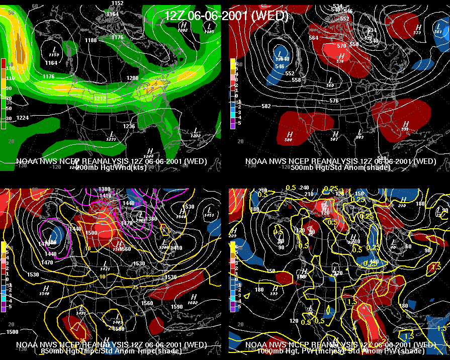
However, 24 to 36 hours later the SE weakened while the W. TX High strengthened causing Allison to stall and to eventually drift slowly back to the south toward the Houston Metro area.
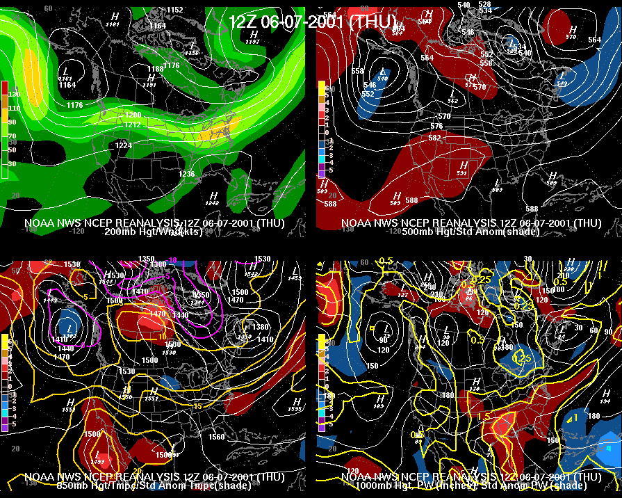 Ultimately, these weak steering currents are what lead to the historic excessive rains over SE Texas and Louisiana during this time.
 The scenario I proposed above is just me thinking out loud and not any type of official forecast going forward in regards to any potential tropical development in the Gulf of Mexico within the next 10 to 14 days or so. However, it is a scenario that Gulf Coast State residents should be wary of, especially during the month of June, because these types of synoptic patterns involving tropical systems are notorious for producing regional excessive heavy rainfall events.
Last edited by 869MB on Mon Jun 07, 2021 7:55 pm, edited 1 time in total.
-
Stormlover2020
- Posts: 457
- Joined: Mon Jun 01, 2020 6:04 pm
- Contact:
Won’t matter till it’s about 3 days out
-
Stratton20
- Posts: 4248
- Joined: Tue Feb 09, 2021 11:35 pm
- Location: College Station, Texas
- Contact:
I am going on vacation to Panama City, Florida on the 19th so im hoping nothing crazy happens in the gulf, but you never know, we should just stick a sign saying “Never Trust The Gulf During Hurricane Season”

It’s incredibly way to early to speculate anything when there is literally nothing to look at on satellite right now. Models are fun to watch and all, but quite frankly, it’s mostly entertainment after 5 days and even more so 6-7+ days out.
It’s wise to remember that while models have greatly improved, and will continue to do so, they are only a part of forecasting weather. If you live and die by watching models then you’re going to be wrong way more times than you’re right. Even more so before there is any area of interest.
It’s wise to remember that while models have greatly improved, and will continue to do so, they are only a part of forecasting weather. If you live and die by watching models then you’re going to be wrong way more times than you’re right. Even more so before there is any area of interest.
It’s fun for us to speculate. Most of us are all fully aware you can’t trust models more than 3 days out but many of us here are big weather enthusiasts and it’s exciting for us to talk about.davidiowx wrote: ↑Mon Jun 07, 2021 7:08 pm It’s incredibly way to early to speculate anything when there is literally nothing to look at on satellite right now. Models are fun to watch and all, but quite frankly, it’s mostly entertainment after 5 days and even more so 6-7+ days out.
It’s wise to remember that while models have greatly improved, and will continue to do so, they are only a part of forecasting weather. If you live and die by watching models then you’re going to be wrong way more times than you’re right. Even more so before there is any area of interest.
Great post! Post more like it lol it’s absolutely true that if a trough does lift out in time a storm is likely to go further west.869MB wrote: ↑Mon Jun 07, 2021 6:40 pmJust using that GFS 240 Hour Forecast Map for illustrative purposes, a scenario is not out of the realm of possibility where there's a weakness strong enough to pull a tropical system to the north but quickly lifts out to the NE leaving a system meandering around somewhere near the NW Gulf of Mexico / TX Coast or North Central Gulf Coast / SE States - Such system can theoretically get stuck in between one High Pressure centered over New Mexico/W. Texas and a second High Pressure centered somewhere over the SW Atlantic.
We saw a scenario similar to the one I described above back in June of 2001 with Tropical Storm Allison. After Allison made landfall here on the Upper Texas Coast, steering currents broke down between two High-Pressure areas - One High was centered over W. Texas/ E. NM, and while the 2nd High was centered to the east over the SW Atlantic. Initially, the High Pressure over the SW Atlantic was stronger steering Allison to the north of the Houston Metro area.
However, 24 to 36 hours later the SE weakened while the W. TX High strengthened causing Allison to stall and to eventually drift slowly back to the south toward the Houston Metro area.
The scenario I proposed above is just me thinking out loud and not any type of official forecast going forward in regards to any potential tropical development in the Gulf of Mexico within the next 10 to 14 days or so. However, it is a scenario that Gulf Coast State residents should be wary of, especially during the month of June, because these types of synoptic patterns involving tropical systems are notorious for producing regional excessive heavy rainfall events.
-
Stratton20
- Posts: 4248
- Joined: Tue Feb 09, 2021 11:35 pm
- Location: College Station, Texas
- Contact:
Plus even though this system is still a good 7-8 days from reaching the gulf, at the very least we can get hints and indications of what could happen in the coming days from these model runs
I completely understand that but keep in mind people use this forum for information as well. Not everyone is a weather enthusiast or know anything about it. This is a great site and there are a lot of knowledge people here, including yourself. We can discuss models and criticize them, laugh at them, or say how good they are. It’s all part of good discussions.Cpv17 wrote: ↑Mon Jun 07, 2021 7:15 pmIt’s fun for us to speculate. Most of us are all fully aware you can’t trust models more than 3 days out but many of us here are big weather enthusiasts and it’s exciting for us to talk about.davidiowx wrote: ↑Mon Jun 07, 2021 7:08 pm It’s incredibly way to early to speculate anything when there is literally nothing to look at on satellite right now. Models are fun to watch and all, but quite frankly, it’s mostly entertainment after 5 days and even more so 6-7+ days out.
It’s wise to remember that while models have greatly improved, and will continue to do so, they are only a part of forecasting weather. If you live and die by watching models then you’re going to be wrong way more times than you’re right. Even more so before there is any area of interest.
However, statements insinuating a storm is coming next week, when there is nothing to suggest that other than some long range model outputs, is a little extreme. If the models show this for several days then it’s something to start watching. All I’m saying there’s no need for some to be so adamant about a storm when in fact, it’s a complete mystery at this point.
-
Stratton20
- Posts: 4248
- Joined: Tue Feb 09, 2021 11:35 pm
- Location: College Station, Texas
- Contact:
NHC has increased odds of this systems formation up to 30% now in the next 5 days
Thank you. That was my point. Yes, we are weather enthusiasts and while we all enjoy reading/discussing/imagining the possibilities, we have to be mindful of our ever-growing lurkers who may misinterpret misinformation as a “forecast” when it it’s nothing of the sort. It’s one reason why we have the disclaimer on S2K - you never know what some folks will toss out there for fodder.davidiowx wrote: ↑Mon Jun 07, 2021 7:25 pmI completely understand that but keep in mind people use this forum for information as well. Not everyone is a weather enthusiast or know anything about it. This is a great site and there are a lot of knowledge people here, including yourself. We can discuss models and criticize them, laugh at them, or say how good they are. It’s all part of good discussions.Cpv17 wrote: ↑Mon Jun 07, 2021 7:15 pmIt’s fun for us to speculate. Most of us are all fully aware you can’t trust models more than 3 days out but many of us here are big weather enthusiasts and it’s exciting for us to talk about.davidiowx wrote: ↑Mon Jun 07, 2021 7:08 pm It’s incredibly way to early to speculate anything when there is literally nothing to look at on satellite right now. Models are fun to watch and all, but quite frankly, it’s mostly entertainment after 5 days and even more so 6-7+ days out.
It’s wise to remember that while models have greatly improved, and will continue to do so, they are only a part of forecasting weather. If you live and die by watching models then you’re going to be wrong way more times than you’re right. Even more so before there is any area of interest.
However, statements insinuating a storm is coming next week, when there is nothing to suggest that other than some long range model outputs, is a little extreme. If the models show this for several days then it’s something to start watching. All I’m saying there’s no need for some to be so adamant about a storm when in fact, it’s a complete mystery at this point.
Good deal. Of course, the idea behind the post was to provide some historical reference with respect to the map you posted and not infer some long-range speculatively based forecast insinuating we're about to experience another historic tropical storm.Cpv17 wrote: ↑Mon Jun 07, 2021 7:17 pmGreat post! Post more like it lol it’s absolutely true that if a trough does lift out in time a storm is likely to go further west.869MB wrote: ↑Mon Jun 07, 2021 6:40 pmJust using that GFS 240 Hour Forecast Map for illustrative purposes, a scenario is not out of the realm of possibility where there's a weakness strong enough to pull a tropical system to the north but quickly lifts out to the NE leaving a system meandering around somewhere near the NW Gulf of Mexico / TX Coast or North Central Gulf Coast / SE States - Such system can theoretically get stuck in between one High Pressure centered over New Mexico/W. Texas and a second High Pressure centered somewhere over the SW Atlantic.
We saw a scenario similar to the one I described above back in June of 2001 with Tropical Storm Allison. After Allison made landfall here on the Upper Texas Coast, steering currents broke down between two High-Pressure areas - One High was centered over W. Texas/ E. NM, and while the 2nd High was centered to the east over the SW Atlantic. Initially, the High Pressure over the SW Atlantic was stronger steering Allison to the north of the Houston Metro area.
However, 24 to 36 hours later the SE weakened while the W. TX High strengthened causing Allison to stall and to eventually drift slowly back to the south toward the Houston Metro area.
The scenario I proposed above is just me thinking out loud and not any type of official forecast going forward in regards to any potential tropical development in the Gulf of Mexico within the next 10 to 14 days or so. However, it is a scenario that Gulf Coast State residents should be wary of, especially during the month of June, because these types of synoptic patterns involving tropical systems are notorious for producing regional excessive heavy rainfall events.
Yeah I agree with all of that and I’m fully aware we have lurkers here that aren’t as weather savvy as many of us are on here. I’ve known that for years now, even before I joined to be a member. It’s always good to remind everyone of that every once in a while. However, you can’t completely discount something forming in the Gulf or Bay of Campeche this time of year. Climo suggests a CAG system could be likely. It’s just something to keep an eye on. We won’t likely know much till this weekend.davidiowx wrote: ↑Mon Jun 07, 2021 7:25 pmI completely understand that but keep in mind people use this forum for information as well. Not everyone is a weather enthusiast or know anything about it. This is a great site and there are a lot of knowledge people here, including yourself. We can discuss models and criticize them, laugh at them, or say how good they are. It’s all part of good discussions.Cpv17 wrote: ↑Mon Jun 07, 2021 7:15 pmIt’s fun for us to speculate. Most of us are all fully aware you can’t trust models more than 3 days out but many of us here are big weather enthusiasts and it’s exciting for us to talk about.davidiowx wrote: ↑Mon Jun 07, 2021 7:08 pm It’s incredibly way to early to speculate anything when there is literally nothing to look at on satellite right now. Models are fun to watch and all, but quite frankly, it’s mostly entertainment after 5 days and even more so 6-7+ days out.
It’s wise to remember that while models have greatly improved, and will continue to do so, they are only a part of forecasting weather. If you live and die by watching models then you’re going to be wrong way more times than you’re right. Even more so before there is any area of interest.
However, statements insinuating a storm is coming next week, when there is nothing to suggest that other than some long range model outputs, is a little extreme. If the models show this for several days then it’s something to start watching. All I’m saying there’s no need for some to be so adamant about a storm when in fact, it’s a complete mystery at this point.
I don’t think anyone is ‘discounting’ the possibility of something developing right now, but there is a fine line between saying something might happen and something will “likely” happen and assessing an intensity on top. Still a wee bit early to take it that far.
This is coming straight from NOAA/CPC. They’re saying there’s a high chance for development in the sw Caribbean or Bay of Campeche sometime between June 9th through 15th.
-
- Information
-
Who is online
Users browsing this forum: Ahrefs [Bot], Amazon [Bot], Bing [Bot], Semrush [Bot] and 130 guests