
June 2021:
-
Stratton20
- Posts: 4246
- Joined: Tue Feb 09, 2021 11:35 pm
- Location: College Station, Texas
- Contact:
00z EURO around days 9-10 is hinting at the formation of a tropical system in the western or Northwestern Caribbean, something to monitor as the week goes by
When is go time for the next heavy rain event to begin? This evening?

Area Forecast Discussion
National Weather Service Houston/Galveston TX
437 AM CDT Wed Jun 2 2021
.SHORT TERM [Today Through Thursday Night]...
Light winds this morning over the area with a diffuse cold front
that has crept down through Conroe and Caldwell. Patchy fog near
Conroe/Caldwell/Cleveland will be short lived as the sun comes up.
Temperatures rise quickly this morning and should climb into the
mid 80s and with that scattered storms should develop along and
south of the frontal boundary this afternoon. Slow moving storms
could bring a quick inch of rainfall. A s/w dropping southeast
should approach the region with active convection associated with
it to the west late in the afternoon and evening. The most likely
scenario is that the large cluster of storms stays to the west of
the region but a few models indicate it could expand into the
southwest and western areas tonight. Have trended up on rain
chances there - but not going in whole hog yet. Thursday the
upper jet becomes more favorably aligned as the upper trough
moves northeast and the influence of the upper low near Baja
swings up the subtropical jet. Soundings indicate the end of the
cap with enough moisture but the frontal boundary will be lifting
north so scattered showers and thunderstorms in the morning could
easily become more numerous in the afternoon with heating
potentially shifting the coverage northward and possibly tapering
down near the coast. Wind profiles indicate that in general storms
should be northward morning at 10-15 knots which should give the
area a good soaking (not that it needs it)...yes some heavy
downpours but probably more in the nuisance/isolated street
flooding range. A more potent s/w moving through Mexico Thursday
night could begin to bring in showers toward sunrise as the
subtropical jet strengthens. 45
&&
.LONG TERM [Friday Through Wednesday]...
The upcoming weekend remains in focus as potentially the most
impactful portion of the upcoming extended stretch of unsettled
weather across SE TX. By early Friday, the prevailing upper trough
axis will continue to drift eastward, along with an associated
jet streak to its south. Global models continue to place SE TX
within the left rear quadrant of this jet streak, which will
provide favorable upper-level divergence necessary to sustain
heavy rainfall. Surface flow will remain out of the south to
southeast as surface high pressure remains situated over the
southeastern CONUS while pressures deepen over Western TX. This
persistent flow pattern will provide the region with ample low
level moisture, with total PWs nearing 2.0 in by Friday and
potentially exceeding it on Saturday. As a series of shortwaves
round the prevailing midlevel trough axis, there will be multiple
rounds of showers and storms through the duration of the weekend
and likely into early next week. Based on the current expected
synoptic pattern reflected by the latest round of deterministic
global model solutions, the potential for heaviest rainfall looks
to be in the late Saturday-early Sunday time frame. Those with
travel or event plans this weekend should continue to monitor the
forecast closely.
WPC continues to forecast 3-5" of total rainfall over SE TX over the
next 7 days, with the bulk of this precipitation occuring between
Saturday morning and Monday morning. As I discussed yesterday, these
values represent areal averages and locally higher totals driven by
individual strong storms that develop over the course of this event
are certainly possible. Flash Flood Watches may be required in the
coming days as the forecast continues to be refined.
As the upper trough axis continues to slowly jog eastward heading
into the early part of next week, jet dynamics become less favorable
for heavy rainfall. That being said, continued onshore winds and the
propagation of additional midlevel shortwaves across SE TX will
continue to prove favorable for the development of showers and
storms with locally heavy rainfall remaining a concern. By the end
of next week, indications are that upper ridging will build into the
central CONUS and the rainy pattern may finally come to an end.
Not much change to the temperature forecast tonight with below-
normal daytime highs still expected, aided by persistent cloud cover
and periods of rainfall. Most locations remain confined to the low-
mid 80s into the early part of next week. Lows will remain closer to
normal as broken to overcast decks inhibit radiative cooling, with
values staying in the upper 60s/low 70s inland and in the mid 70s
along the coast.
The 0z Euro came in with its most wet run yet showing 6 to 13” across southeast TX.
I think the best opportunity for rain today will be from about 2pm-7pm. Some areas could pick up a quick inch if you get caught in one of the heavier showers.
Actually the WPC is predicting 5-7” with isolated totals of 7-10”.don wrote: ↑Wed Jun 02, 2021 7:55 am Area Forecast Discussion
National Weather Service Houston/Galveston TX
437 AM CDT Wed Jun 2 2021
.SHORT TERM [Today Through Thursday Night]...
Light winds this morning over the area with a diffuse cold front
that has crept down through Conroe and Caldwell. Patchy fog near
Conroe/Caldwell/Cleveland will be short lived as the sun comes up.
Temperatures rise quickly this morning and should climb into the
mid 80s and with that scattered storms should develop along and
south of the frontal boundary this afternoon. Slow moving storms
could bring a quick inch of rainfall. A s/w dropping southeast
should approach the region with active convection associated with
it to the west late in the afternoon and evening. The most likely
scenario is that the large cluster of storms stays to the west of
the region but a few models indicate it could expand into the
southwest and western areas tonight. Have trended up on rain
chances there - but not going in whole hog yet. Thursday the
upper jet becomes more favorably aligned as the upper trough
moves northeast and the influence of the upper low near Baja
swings up the subtropical jet. Soundings indicate the end of the
cap with enough moisture but the frontal boundary will be lifting
north so scattered showers and thunderstorms in the morning could
easily become more numerous in the afternoon with heating
potentially shifting the coverage northward and possibly tapering
down near the coast. Wind profiles indicate that in general storms
should be northward morning at 10-15 knots which should give the
area a good soaking (not that it needs it)...yes some heavy
downpours but probably more in the nuisance/isolated street
flooding range. A more potent s/w moving through Mexico Thursday
night could begin to bring in showers toward sunrise as the
subtropical jet strengthens. 45
&&
.LONG TERM [Friday Through Wednesday]...
The upcoming weekend remains in focus as potentially the most
impactful portion of the upcoming extended stretch of unsettled
weather across SE TX. By early Friday, the prevailing upper trough
axis will continue to drift eastward, along with an associated
jet streak to its south. Global models continue to place SE TX
within the left rear quadrant of this jet streak, which will
provide favorable upper-level divergence necessary to sustain
heavy rainfall. Surface flow will remain out of the south to
southeast as surface high pressure remains situated over the
southeastern CONUS while pressures deepen over Western TX. This
persistent flow pattern will provide the region with ample low
level moisture, with total PWs nearing 2.0 in by Friday and
potentially exceeding it on Saturday. As a series of shortwaves
round the prevailing midlevel trough axis, there will be multiple
rounds of showers and storms through the duration of the weekend
and likely into early next week. Based on the current expected
synoptic pattern reflected by the latest round of deterministic
global model solutions, the potential for heaviest rainfall looks
to be in the late Saturday-early Sunday time frame. Those with
travel or event plans this weekend should continue to monitor the
forecast closely.
WPC continues to forecast 3-5" of total rainfall over SE TX over the
next 7 days, with the bulk of this precipitation occuring between
Saturday morning and Monday morning. As I discussed yesterday, these
values represent areal averages and locally higher totals driven by
individual strong storms that develop over the course of this event
are certainly possible. Flash Flood Watches may be required in the
coming days as the forecast continues to be refined.
As the upper trough axis continues to slowly jog eastward heading
into the early part of next week, jet dynamics become less favorable
for heavy rainfall. That being said, continued onshore winds and the
propagation of additional midlevel shortwaves across SE TX will
continue to prove favorable for the development of showers and
storms with locally heavy rainfall remaining a concern. By the end
of next week, indications are that upper ridging will build into the
central CONUS and the rainy pattern may finally come to an end.
Not much change to the temperature forecast tonight with below-
normal daytime highs still expected, aided by persistent cloud cover
and periods of rainfall. Most locations remain confined to the low-
mid 80s into the early part of next week. Lows will remain closer to
normal as broken to overcast decks inhibit radiative cooling, with
values staying in the upper 60s/low 70s inland and in the mid 70s
along the coast.

Will bear the mosquitos...no way am I complaining about rain this time of year in this area of Texas and tempting the Death Ridge gods! 
-
TexasBreeze
- Posts: 942
- Joined: Sun Sep 26, 2010 4:46 pm
- Location: NW Houston, TX
- Contact:
The Ecmwf sure is cranking out the rain totals lately for the whole area.
-
MontgomeryCoWx

- Posts: 2356
- Joined: Wed Dec 14, 2011 4:31 pm
- Location: Weimar, TX
- Contact:
No complaints from my end. 80 and off and on rain in June sure as hell beats 90s and muggy with no rain in sight.
Team #NeverSummer
Updated map from the WPC:
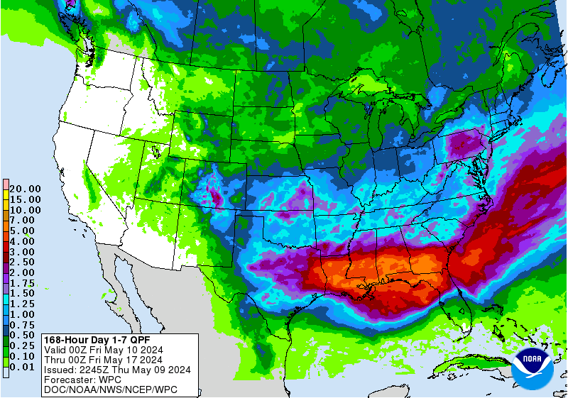
Shows even some isolated pockets of 7-10”.
Shows even some isolated pockets of 7-10”.
-
Stratton20
- Posts: 4246
- Joined: Tue Feb 09, 2021 11:35 pm
- Location: College Station, Texas
- Contact:
Might want to put a + after 7-10, definitely thinking some areas might receive even more than that
I agree. Some areas could receive that in one day alone.Stratton20 wrote: ↑Wed Jun 02, 2021 4:46 pm Might want to put a + after 7-10, definitely thinking some areas might receive even more than that
-
Stratton20
- Posts: 4246
- Joined: Tue Feb 09, 2021 11:35 pm
- Location: College Station, Texas
- Contact:
Just hope we dont getting any severe storms though, a few days ago we had a big wind storm which caused our basketball goal to fall on my car
-
MontgomeryCoWx
- Posts: 2356
- Joined: Wed Dec 14, 2011 4:31 pm
- Location: Weimar, TX
- Contact:
I had to buy lye to put outside our chicken coop. It was just a muddy, sh***y mess from their droppings. I also ran a splitter off the extension cord and plugged in two "drying fans" on it. It finally dried up today. I'm going to keep them running until our next big storm. I see my area is in that 7-10 range.
Headed back to Colorado County this weekend to our ranch. Our stock pond came out of its banks last week and the buzzards were eating fresh catfish. I may be moving some dirt this weekend to build up the banks.
Despite all of that trouble, I'd still take this weather pattern over the Death Ridge.
Headed back to Colorado County this weekend to our ranch. Our stock pond came out of its banks last week and the buzzards were eating fresh catfish. I may be moving some dirt this weekend to build up the banks.
Despite all of that trouble, I'd still take this weather pattern over the Death Ridge.
Team #NeverSummer
There’s a pretty big warmup with some ridging showing up the last few days on the 12z Euro. Hope that doesn’t verify.MontgomeryCoWx wrote: ↑Wed Jun 02, 2021 5:16 pm I had to buy lye to put outside our chicken coop. It was just a muddy, sh***y mess from their droppings. I also ran a splitter off the extension cord and plugged in two "drying fans" on it. It finally dried up today. I'm going to keep them running until our next big storm. I see my area is in that 7-10 range.
Headed back to Colorado County this weekend to our ranch. Our stock pond came out of its banks last week and the buzzards were eating fresh catfish. I may be moving some dirt this weekend to build up the banks.
Despite all of that trouble, I'd still take this weather pattern over the Death Ridge.
-
Stratton20
- Posts: 4246
- Joined: Tue Feb 09, 2021 11:35 pm
- Location: College Station, Texas
- Contact:
The Euro shows that on days 8-10 , thank goodness thats far out, I domt want a heat ridge here

When thinking about this rain pattern setting up, and there may be a few that don’t like it.
I think of pictures from Bastrop in 2011.
Ugh
I think of pictures from Bastrop in 2011.
Ugh
-
MontgomeryCoWx
- Posts: 2356
- Joined: Wed Dec 14, 2011 4:31 pm
- Location: Weimar, TX
- Contact:
-
Stratton20
- Posts: 4246
- Joined: Tue Feb 09, 2021 11:35 pm
- Location: College Station, Texas
- Contact:
18z GFS run keeps rain chances going all the way through next Saturday, wow!