Page 55 of 56
Re: June 2021:
Posted: Tue Jun 29, 2021 8:15 pm
by unome
jasons2k wrote: ↑Tue Jun 29, 2021 4:20 pm
Nightmare for a pool contractor. My hopes for having this done before Labor Day appear to be diminishing. Murphy’s Law at work I suppose.
First world problems, heh ?
Re: June 2021:
Posted: Tue Jun 29, 2021 8:25 pm
by Cpv17
Looks like 97L has a shot at being classified as early as tomorrow at the rate it’s consolidating.
Re: June 2021:
Posted: Tue Jun 29, 2021 8:27 pm
by Stratton20
CPV17 yep I suspect it will at least become a depression by tommorow, looks very healthy on satillite imagery ,
Re: June 2021:
Posted: Wed Jun 30, 2021 12:30 am
by jasons2k
unome wrote: ↑Tue Jun 29, 2021 8:15 pm
jasons2k wrote: ↑Tue Jun 29, 2021 4:20 pm
Nightmare for a pool contractor. My hopes for having this done before Labor Day appear to be diminishing. Murphy’s Law at work I suppose.
First world problems, heh ?
Umm hmm
https://www.google.com/amp/s/amp.thegua ... o-everyone
Re: June 2021:
Posted: Wed Jun 30, 2021 1:08 am
by 869MB

For the North Atlantic...Caribbean Sea and the Gulf of Mexico:
1. A broad area of low pressure, associated with a tropical wave, is
located about midway between the west coast of Africa and the
Windward Islands. This system is producing a large area of showers
and thunderstorms that continues to show some signs of organization.
Environmental conditions appear generally favorable for development,
and a tropical depression is likely form during the next few days
while the system moves west-northwestward at about 20 mph.
Interests in the Windward and Leeward Islands should closely
monitor this system as it will likely be moving through that region
on Friday.
* Formation chance through 48 hours...medium...50 percent.
* Formation chance through 5 days...high...70 percent.
Re: June 2021:
Posted: Wed Jun 30, 2021 9:04 am
by don
One thing to keep in mind, if a cutoff low does form over the state, that could help to block whatever comes of 97L from Texas if it were to make it into the gulf.Depending on the position and strength of the low.But still a long ways out so alot is likely to change over the next week.
.LONG TERM [Friday Through Wednesday]...
Latest model runs continue to show a wet and rainy holiday
weekend. A deepening mid-level trough over the Great Lakes will
push a cold front through Texas on Friday. This front will reach
the Texas coast by Friday afternoon where it stall and meander
across our CWA over the weekend and into next week. Scattered to
numerous showers are possible along this frontal boundary through
the weekend at any given time, but activity will peak in the
afternoon and early evening each day.
Ingredients are also coming together for potential heavy rainfall
this weekend as well. Early Saturday morning, the GFS and ECMWF
are showing an inverted trough pushing its way into the Gulf from
the Yucatan Peninsula and supplying Southeast Texas with ample
PWATS of 2.2 to 2.4 inches. Forecast soundings show long, skinny
CAPE of 1500-2000 J/kg, so convective growth will be slow and
gradual with long-living showers and storms. Persistent diffluence
aloft will also aid in low-level convergence for convection.
Storm motion appears to be relatively low, so any showers/storms
producing heavy rainfall will be slow moving. Long story short,
plenty of moisture, slow growing storms, slow moving storms, and
persistent low-level convergence all point to heavy rainfall
potential this weekend.
This wet rainy pattern will continue through the work week as
well. Global models are messy regarding the stalled frontal
boundary, but its remnants still appear to be on the coast by
Monday. Meanwhile, an upper-level low will be vertically stacked
with a surface low over the High Plains of Texas on Monday. This
low will push southeast and reach our region by late Monday or
early Tuesday. Much of the same setup is in place regarding PWATS,
instability, and storm motion. This will only keep rain chances
going through mid-week next week with PoPs ranging from 50-80%.
On Friday, daytime highs will reach the lower 90s, but Saturday
onwards, daytime highs will only reach the upper 80s due to cloud
cover and rainfall. Overnight lows will muggy and in the mid-70s.
Re: June 2021:
Posted: Wed Jun 30, 2021 9:27 am
by Stratton20
Even if 97L doesnt effect us I dont really think it matters that much really, a potential cut off low over texas definitely would create some big problems
Re: June 2021:
Posted: Wed Jun 30, 2021 10:14 am
by DoctorMu
unome wrote: ↑Tue Jun 29, 2021 8:15 pm
jasons2k wrote: ↑Tue Jun 29, 2021 4:20 pm
Nightmare for a pool contractor. My hopes for having this done before Labor Day appear to be diminishing. Murphy’s Law at work I suppose.
First world problems, heh ?
Perfect for ice skating next February!

Re: June 2021:
Posted: Wed Jun 30, 2021 11:00 am
by jasons2k
It’s looking like the 4th Fireworks may actually be rained-out this year. I don’t recall this happening as long as I’ve lived here. Of course it’s the year we are (trying to) build a pool.

Got a note from them today the dig is on-hold until the 7-day forecast looks better.
Re: June 2021:
Posted: Wed Jun 30, 2021 11:04 am
by Stratton20
In still shooting fireworks even if its raining, gotta take a bit of risk sometimes

Re: June 2021:
Posted: Wed Jun 30, 2021 11:26 am
by weatherguy425
jasons2k wrote: ↑Wed Jun 30, 2021 11:00 am
It’s looking like the 4th Fireworks may actually be rained-out this year. I don’t recall this happening as long as I’ve lived here. Of course it’s the year we are (trying to) build a pool.
Got a note from them today the dig is on-hold until the 7-day forecast looks better.
The "big" show made it, even after almost everything else was cancelled a few years ago. Maybe a similar action this year? Less spectators, but same show? Though, timing may mean rain well into the evening.
https://www.chron.com/news/houston-texa ... 047480.php
Re: June 2021:
Posted: Wed Jun 30, 2021 11:42 am
by Rip76
Stratton20 wrote: ↑Wed Jun 30, 2021 11:04 am
In still shooting fireworks even if its raining, gotta take a bit of risk sometimes
Do it in the house if you have to.
Re: June 2021:
Posted: Wed Jun 30, 2021 2:30 pm
by Stratton20
Rip76 dont think I want to set my house on fire lol
Re: June 2021:
Posted: Wed Jun 30, 2021 3:05 pm
by Cpv17
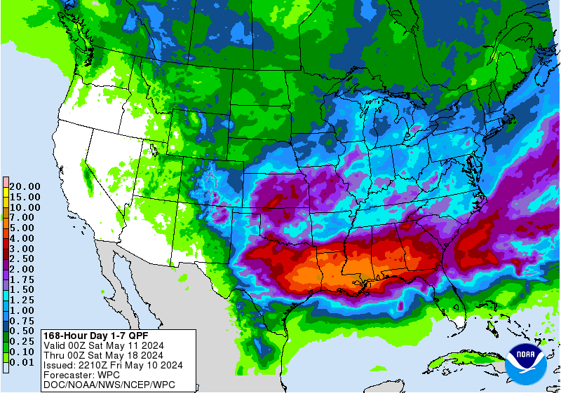
Just another 4-7” on the way for southeast Texas. No big deal
Re: June 2021:
Posted: Wed Jun 30, 2021 3:17 pm
by TexasBreeze
Gfs only has about half that amount the entire noon run. Looks like they prefer Ecmwf.
Re: June 2021:
Posted: Wed Jun 30, 2021 3:23 pm
by Cpv17
TexasBreeze wrote: ↑Wed Jun 30, 2021 3:17 pm
Gfs only has about half that amount the entire noon run. Looks like they prefer Ecmwf.
Check out the latest CMC.
Re: June 2021:
Posted: Wed Jun 30, 2021 3:33 pm
by DoctorMu
Cpv17 wrote: ↑Wed Jun 30, 2021 3:23 pm
TexasBreeze wrote: ↑Wed Jun 30, 2021 3:17 pm
Gfs only has about half that amount the entire noon run. Looks like they prefer Ecmwf.
Check out the latest CMC.
1-2 feet of rain. East of I-45.

We'll see. Models are all over from an inch to a foot.
https://weather.us/model-charts/can/tex ... 0600z.html
Re: June 2021:
Posted: Wed Jun 30, 2021 3:36 pm
by Scott747
Advisories will begin on former 97l. I think it will get a little deeper in the Caribbean than the modeling but for now looks like it would track across Cuba and towards the egom.
Re: June 2021:
Posted: Wed Jun 30, 2021 3:36 pm
by DoctorMu
Re: June 2021:
Posted: Wed Jun 30, 2021 3:55 pm
by Cpv17
Scott747 wrote: ↑Wed Jun 30, 2021 3:36 pm
Advisories will begin on former 97l. I think it will get a little deeper in the Caribbean than the modeling but for now looks like it would track across Cuba and towards the egom.
If I’m being completely honest (and I bet a lot of others feel this way too), I have no interest in tracking a storm that has no chance in coming here. Now I’m not saying it’s not coming here because there’s still a long ways to go but early indications are like you said the eastern Gulf towards Florida. Now if it starts trending west then my interest will be piqued.
