
I noticed yesterday the models were dry for us and the CPC forecast was wet for us. Then today the models turned wetter and the CPC forecast turned drier. Makes zero senseStratton20 wrote: ↑Thu Apr 13, 2023 6:16 pm Both the Euro and GFS are trending much wetter in the medium/long range fwiw
Long range model discussion
-
Stratton20
- Posts: 4682
- Joined: Tue Feb 09, 2021 11:35 pm
- Location: College Station, Texas
- Contact:
Cpv17 i figure it most be the ensembles they are looking at, definitely is head scratching though , though intriguing to see the euro starts to hint at a cut off upper low at the end of its run, we know what those can do
I also think the CPC has trended drier simply because they want to see if the global models are going to consistently be wet like todays runs or if they are going to back off to a more dry solution
 , though intriguing to see the euro starts to hint at a cut off upper low at the end of its run, we know what those can do
I also think the CPC has trended drier simply because they want to see if the global models are going to consistently be wet like todays runs or if they are going to back off to a more dry solution
-
Stratton20
- Posts: 4682
- Joined: Tue Feb 09, 2021 11:35 pm
- Location: College Station, Texas
- Contact:
12z Euro is very active! Wow

Welcome to long-term models.Cpv17 wrote: ↑Thu Apr 13, 2023 7:52 pmI noticed yesterday the models were dry for us and the CPC forecast was wet for us. Then today the models turned wetter and the CPC forecast turned drier. Makes zero senseStratton20 wrote: ↑Thu Apr 13, 2023 6:16 pm Both the Euro and GFS are trending much wetter in the medium/long range fwiw
I have a weather ouija board as well.
-
Stratton20
- Posts: 4682
- Joined: Tue Feb 09, 2021 11:35 pm
- Location: College Station, Texas
- Contact:
00z GFS next 10 days, definitely has trended wetter, good soaking rains for many
- Attachments
-
-
Stratton20
- Posts: 4682
- Joined: Tue Feb 09, 2021 11:35 pm
- Location: College Station, Texas
- Contact:
Interesting to see the GFS is trying to develop what may be a cut off upper low out in the desert SW in the medium range, that could make things interesting going forward
Mid to late first week of May is looking pretty interesting, for now anyway.
-
Stratton20
- Posts: 4682
- Joined: Tue Feb 09, 2021 11:35 pm
- Location: College Station, Texas
- Contact:
12z CMC sees a cut off upper low slowly moving east across the desert southwest, first week of may looks pretty wet
-
Stratton20
- Posts: 4682
- Joined: Tue Feb 09, 2021 11:35 pm
- Location: College Station, Texas
- Contact:
00z Euro drags a front in here next week and stalls it out, chance of daily thunderstorms after the 4th and beyond
May 10-17. Looks like a major low blasting across the Midwest with The Last FROPA of the season digging hard and lifting some hot, humid air: EFS, GEFS, GEPS Ensembles have all bought into mega rain.
-
Stratton20
- Posts: 4682
- Joined: Tue Feb 09, 2021 11:35 pm
- Location: College Station, Texas
- Contact:
And the 00z euro Kicks off the unofficial start of hurricane season with a weak system approaching the mississippi delta at hour 240, let the long nights of model watching and ridiculous GFS fantasy runs commence!

There’s some ensemble support from both the GFS and Euro but it’s a really weak signal for now.Stratton20 wrote: ↑Fri May 19, 2023 2:23 am And the 00z euro Kicks off the unofficial start of hurricane season with a weak system approaching the mississippi delta at hour 240, let the long nights of model watching and ridiculous GFS fantasy runs commence!
-
Stratton20
- Posts: 4682
- Joined: Tue Feb 09, 2021 11:35 pm
- Location: College Station, Texas
- Contact:
12z EPS has good support for * Potentially * our first tropical system of the season, hope it brings rain to florida cause thise folks need it badly
For the heart of hurricane season:
-
Stratton20
- Posts: 4682
- Joined: Tue Feb 09, 2021 11:35 pm
- Location: College Station, Texas
- Contact:
Cpv17 yikes

There will be plenty of El Niño shear. Lots of lemonade (weak systems wandering inland) to keep our grass and trees happy for a change this summer. Fingers crossed.
-
Stratton20
- Posts: 4682
- Joined: Tue Feb 09, 2021 11:35 pm
- Location: College Station, Texas
- Contact:
DoctorMu for the most part their should be, but i do think their will be a window of opportunity for development where the shear isnt high, i wouldnt mind a couple of weakt sloppy systems to keep the grass green but i definitely dont want a hurricane either, just gotta watch it
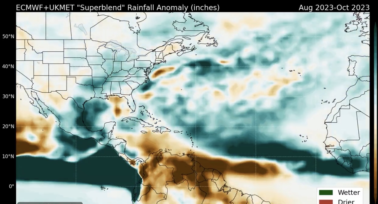
Shear is rockin' already in the GOM and Caribbean.
Weaksauce systems and unfocused rain, FTW. Fingers crossed.
Weaksauce systems and unfocused rain, FTW. Fingers crossed.
- Attachments
-
-
-
Stratton20
- Posts: 4682
- Joined: Tue Feb 09, 2021 11:35 pm
- Location: College Station, Texas
- Contact:
we will see, as they say hope for the best but prepare for the worst, all it takes is one tropical disturbance to get into a pocket of lower shear and dry air and its game on, its just a matter of who gets hit, but thats in the august- october timeframe, seems like june-july are almost always dead months with the occasional homegrown system
It’s normal for the shear maps to look like that this time of the year.