

I'd say so. HGX is going with streamer showers. But they will ride on the easterlies, unusual for TX in summer unless there is some tropical wave in the Gulf underneath the ridge.
I noticed outside there's a slight easterly breeze in CLL. That *could* bring a small chance of rain this afternoon.
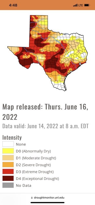
June 2022

It’s 104 here. I see storms to the east - maybe they can hold together. Back to the pool…
-
Stratton20
- Posts: 4246
- Joined: Tue Feb 09, 2021 11:35 pm
- Location: College Station, Texas
- Contact:
If their is any glimmer of hope, its the latest NOAA update is trending away from below normal precipitation in the 8-14 day range, hopefully this is a sign that a pattern change may be coming
- Attachments
-
101°F at The Woodlands official site. That's really hot. It's usually a few degrees cooler than HOU and Spring.
Hottest day of the year here today. Just hit 99°. Heat index isn’t too bad though, thankfully. DP is just 65°.
Yikes. Even NOAA has it getting even hotter next weekend.
As predicted, spotty cells along the pseudo-FROPA separating Hot from Really, Really Hot...moving NW.
They are unlikely to reach even I-45 by nightfall. A rogue cell could appear. Hopes are very faint.
Happy Father's Day everyone!
They are unlikely to reach even I-45 by nightfall. A rogue cell could appear. Hopes are very faint.
Happy Father's Day everyone!
- Attachments
-

Strong thunderstorms over me now. Hallelujah. Temp went from 99 to currently 79. Man it feels good. Love rain cooled air. Especially after 100 day like today.
Mike
Beaumont, TX
(IH-10 & College Street)
Beaumont, TX
(IH-10 & College Street)
This is pretty bad:
-
Stratton20
- Posts: 4246
- Joined: Tue Feb 09, 2021 11:35 pm
- Location: College Station, Texas
- Contact:
That is absolutely brutal

Somebody make it stop. Uncle! Uncle!
Can this high pressure be over now?
Can this high pressure be over now?
-
Stratton20
- Posts: 4246
- Joined: Tue Feb 09, 2021 11:35 pm
- Location: College Station, Texas
- Contact:
Man i hope the 00z GFS is right next week, has a backdoor front moving in and stalling leading to a few days of scattered showers/storms

GFS, CMC, Euro see a front around the 27th. We'll see.
On this day in 2017. TS Cindy was aimed right for SETX. Im scrolling my memories on FB looking at all the forecasted rain that we got. 4-6” of rain with gusts of wind 50mph. What I would do right now to have a tropical storm Cindy in my background Right NOW!! Just looking at all the graphics of rain and wind gives me a feeling of losing an old friend. Lol. It sure is purty to look at though while its 100+ outside with no chance of rain.
Mike
Beaumont, TX
(IH-10 & College Street)
Beaumont, TX
(IH-10 & College Street)
-
captainbarbossa19

- Posts: 401
- Joined: Mon Jun 28, 2021 2:50 pm
- Location: Starkville, MS
- Contact:
I haven't had measurable rain since May. I am starting to think that a tropical system is really what it will take to break this cycle.
-
Stratton20
- Posts: 4246
- Joined: Tue Feb 09, 2021 11:35 pm
- Location: College Station, Texas
- Contact:
FWIW the 12z CMC develops a weak surface Low in the gulf and tracks it towards texas as it rides around the southern flank of high pressure, could bring us some badly needed rain if that verified, nothing tropical, but just something interesting to see, will see what the Euro says
Edit: The 12z Euro also has a broad but weak surface low tracking westward in the gulf, something to monitor into next week
Edit: The 12z Euro also has a broad but weak surface low tracking westward in the gulf, something to monitor into next week
- Attachments
-

Most of the global models are starting to sniff out a weak surface low that detaches from a front on the east coast.And possibly moves into the gulf heading west towards the Texas coast next week.Something to watch as such setups can sometimes produce homebrew TC's.
- Attachments
-
-
-
Last edited by don on Mon Jun 20, 2022 2:37 pm, edited 1 time in total.
-
captainbarbossa19
- Posts: 401
- Joined: Mon Jun 28, 2021 2:50 pm
- Location: Starkville, MS
- Contact:
Actually, the Euro and CMC both show a weak low over the Gulf so that would almost certainly be tropical given the environment. Waiting to look at shear maps for the Euro, but the GFS currently shows rather light shear over the system. The low looks to be embedded in rather deep moisture.Stratton20 wrote: ↑Mon Jun 20, 2022 1:55 pm FWIW the 12z CMC develops a weak surface Low in the gulf and tracks it towards texas as it rides around the southern flank of high pressure, could bring us some badly needed rain if that verified, nothing tropical, but just something interesting to see, will see what the Euro says
Edit: The 12z Euro also has a broad but weak surface low tracking westward in the gulf, something to monitor into next week