


There have been cold blasts in La Nina winters. February 1895, February 1899, December 1924, February 1933, January/February 1951, January 1962, January/February 1985, February 1989, February 1996, February 2011, and February 2021 occurred in La Nina winters.srainhoutx wrote: ↑Sun Aug 14, 2022 4:23 pmAnd the winter before last. Everyone remembers the debacle with the usually cold outbreak and no power. There are signals of a trough setting up for prolonged periods across the Northern Rockies into the Great Plains on East. I'm watching the mid to late December time frame into January for and active period for Texas.brazoriatx wrote: ↑Sun Aug 14, 2022 4:14 pm Wasnt last winter a la Nina? It stopped us from actually getting cold....ugh not again!
August 2022
Last edited by Ptarmigan on Sun Aug 14, 2022 7:06 pm, edited 1 time in total.
-
MontgomeryCoWx

- Posts: 2356
- Joined: Wed Dec 14, 2011 4:31 pm
- Location: Weimar, TX
- Contact:
Easily my favorite poster with his black and white statistical postsPtarmigan wrote: ↑Sun Aug 14, 2022 6:58 pmThere have been cold blasts in La Nina winters. February 1895, February 1899, December 1924, February 1933, January 1962, January/February 1985, February 1989, February 1996, February 2011, and February 2021 occurred in La Nina winters.srainhoutx wrote: ↑Sun Aug 14, 2022 4:23 pmAnd the winter before last. Everyone remembers the debacle with the usually cold outbreak and no power. There are signals of a trough setting up for prolonged periods across the Northern Rockies into the Great Plains on East. I'm watching the mid to late December time frame into January for and active period for Texas.brazoriatx wrote: ↑Sun Aug 14, 2022 4:14 pm Wasnt last winter a la Nina? It stopped us from actually getting cold....ugh not again!
No offense meant to anyone else. You all are great too.
Team #NeverSummer
There was an ice storm in December 1924. It was a big one.
https://books.google.com/books?id=56lhL ... on&f=false
There were ice storms on January 2, 1919, January 22, 1940, and January-February 1951.
https://books.google.com/books?id=56lhL ... on&f=false
There were ice storms on January 2, 1919, January 22, 1940, and January-February 1951.

Morning update from Jeff:
Impressive “tropical system” over SW TX this morning with a well defined center located NW of Laredo TX.
98L made landfall near Kingsville TX early Sunday and has brought widespread and in some cases significant rainfall to southern Texas where some places have seen more rainfall in the last 36 hours than much of this year. 98L will continue to move WNW in the general direction of Big Bend over the next 24 hours with a moisture feed and low level convergence shifting westward toward the Rio Grande and then into eastern MX as high pressure builds in from the NE. While moisture is still in place over SE TX today, building upper level heights will help to cap off much activity along the seabreeze.
Forecast will be mainly dry and hot through Wednesday with high pressure back in control. Lack of rainfall the last few days over the Brazos Valley area will result in afternoon temperatures back into the low 100’s as early as today and through Wednesday.
Upper air pattern will undergo significant transition toward the middle and end of the week with a large trough developing over the eastern US which will help drive a surface boundary down into TX and possibly into the Gulf waters. Showers and thunderstorms will begin to increase on Thursday as the boundary sinks into the area from the north and then lingers near the coast or offshore into next weekend. At the same time a strong tropical wave will be moving westward from the Caribbean Sea toward the Yucatan and the southern Gulf of Mexico. This tropical wave will then turn NW over the Gulf and move toward the western Gulf next weekend south of the stalled frontal boundary. Both the GFS and ECMWF have been hinting at surface low pressure developing with this tropical wave axis over the western Gulf of Mexico next weekend. End result is likely a wet weather pattern starting on Thursday and lasting into next weekend and even the following week.
Tropics:
Several areas to watch over the next 5-10 days as favorable phase of the MJO moves into the Atlantic basin. Southern/western Gulf late this week into next weekend. Additionally several strong tropical waves will be moving off the western coast of Africa and there is some global model support that these waves may attempt to develop as they move westward across the Atlantic basin.
Jeff Lindner
Director Hydrologic Operations Division/Meteorologist
Harris County Flood Control District
-
Stratton20
- Posts: 4248
- Joined: Tue Feb 09, 2021 11:35 pm
- Location: College Station, Texas
- Contact:
Models are trending drier with this pattern….. Always how it goes, looks like a pattern change is coming, models get your hopes up for a few days and then wham, the drying trend begins.. Typical
Keeping an eye on this…
- Attachments
-
Surprise surprise lolStratton20 wrote: ↑Mon Aug 15, 2022 11:48 am Models are trending drier with this pattern….. Always how it goes, looks like a pattern change is coming, models get your hopes up for a few days and then wham, the drying trend begins.. Typical
-
Stratton20
- Posts: 4248
- Joined: Tue Feb 09, 2021 11:35 pm
- Location: College Station, Texas
- Contact:
Cpv17 I hope im wrong though, plenty of time for change though, just dont like todays trends though
-
tireman4

- Global Moderator

- Posts: 4483
- Joined: Wed Feb 03, 2010 9:24 pm
- Location: Humble, Texas
- Contact:
000
FXUS64 KHGX 151719
AFDHGX
Area Forecast Discussion
National Weather Service Houston/Galveston TX
1219 PM CDT Mon Aug 15 2022
.AVIATION [18Z TAF Issuance]...
VFR conditions will continue throughout most of the TAF period
with light to moderate S/SE flow expected to continue throughout
the afternoon. A few isolated showers may develop near the coast
this afternoon, though coverage is too sparse to be worth
mentioning in the TAF. Winds will diminish this evening, becoming
light and variable overnight. Patchy fog many develop at KLBX
overnight, potentially bringing reduced visibility through early
Tuesday morning. Any fog that does develop should clear after
sunrise on Tuesday as light to moderate S/SE winds develop across
the region.
03
&&
.PREV DISCUSSION /Issued 558 AM CDT Mon Aug 15 2022/...
.SHORT TERM [Through Tuesday Night]..
The shields appear to be up early this morning, as virtually all
of the rain is falling farther down the coast, out of our forecast
area. There are a couple lonely showers over Matagorda County near
0230 am, and I expect that we`ll manage to fill in a few more
coastal showers in the pre-dawn hours with onshore flow persistent
again across the area. I have some slight chances of rain along a
seabreeze boundary from the Matagorda Bay area up to the Houston
metro, but the farther we get from the main activity in South
Texas, the more we`ll fall under the influence of growing
subsidence as ridging aloft works to build in overhead, eventually
choking out rain chances entirely.
Instead, today, most of us will be returning to the tradition of
this summer - thermometer watching. Well inland, away from even
our slimmest of rain chances, expect highs to reach near, or even
just exceed 100 degrees...again. I know we didn`t get much of a
break, but if anything, Tuesday looks even a little bit hotter.
It`s too early to make any definitive statements as I`d like to
see how today goes, but a heat advisory for a portion of the area
might be needed on Tuesday. As of now, I`d lean against needing an
advisory, but my forecast tonight is very near the thresholds.
If today overperforms for heat, Tuesday might as well. And rain
chances? Tomorrow? This is where I have some uncomfortable
laughter. With the South Texas low out of the picture, we`ll be
fully under the influence of high pressure throughout the column,
with the center of the midlevel high pretty close to smack
overhead. We probably should be happy to get whatever scraps of
cloud show up, much less any chance of rain.
.LONG TERM [Wednesday Through Sunday]...
Temperatures peak for the week on Wednesday. South of I-10 and
outside of the Houston metro area, daytime highs will reach the
mid to upper 90s. North of I-10, locations will reach the triple
digits and our northernmost counties could reach near 103 degF.
Elsewhere, dewpoints will remain a few degrees warmer and heat
index values will reach near 108 degF. Overall, between surface
temperature and heat index values, we could be looking at a
possible Heat Advisory on Wednesday. Therefore, Wednesday is the
day to take extra precautions when spending time outdoors and to
practice proper heat safety. Rain chances will be less than 15% in
the afternoon as subsidence and PWs near 1.5" will inhibit most
deep convection.
By Thursday, we can expect a change in the synoptic pattern as a
trough across Eastern CONUS deepens and pushes the tail end of a
front through Texas. Global models have slowed down and weakened
the FROPA slightly, but it should still reach the Southeast Texas
coast by sunset where it will linger through Saturday. Rain
chances peak near 40 to 60% each afternoon. With the help of rain
cooled air and increased cloud cover, temperatures will reach the
low to mid 90s south of Conroe each day while north of Conroe,
temperatures will reach the mid to upper 90s. By Sunday, the front
begins to push east, but a plume of tropical moisture makes its
way north and into Southeast Texas coast as coastal low pushes
south of Brownsville. This moist and unstable airmass should keep
30-40% afternoon rain chances on Sunday and keep afternoon high
temperatures near or just below normal for this time of year.
.MARINE...
Winds will continue to diminish today as high pressure builds in
overhead. Gentle to moderate onshore flow will persist through the
week. Rain chances return to their normal summer patter with
isolated showers offshore in the morning and eventually isolated
showers in our Bays by the afternoon. By Thursday and through the
weekend, rain chances begin to increase again as a front reaches
the coast and stalls.
&&
.PRELIMINARY POINT TEMPS/POPS...
College Station (CLL) 76 103 77 104 79 / 0 10 0 10 10
Houston (IAH) 76 99 77 101 78 / 10 10 0 10 10
Galveston (GLS) 83 92 83 94 83 / 10 10 0 10 10
&&
.HGX WATCHES/WARNINGS/ADVISORIES...
TX...None.
GM...None.
&&
$$
SHORT TERM...Luchs
LONG TERM....Walts
AVIATION...Brokamp
MARINE...Walts
-
Stratton20
- Posts: 4248
- Joined: Tue Feb 09, 2021 11:35 pm
- Location: College Station, Texas
- Contact:
To early to speculate anything but the 12z EPS guidance does like the idea of a BOC system at day 5 fwiw
- Attachments
-

The models and ensembles continue to be consistent for a more typical summer like pattern beginning on Thursday with the FROPA. Hot, but just under (rather than over) 100°F for CLL with 20-40% chance of rain on average through the end of the month. Best chance of rain - Thursday, Friday and then next week.
Three more days of searing heat and humid but dry weather until then.
Sprinklers on stun. Kirk out.
Three more days of searing heat and humid but dry weather until then.
Sprinklers on stun. Kirk out.
For someone that has to work in this heat, I absolutely cannot wait.DoctorMu wrote: ↑Mon Aug 15, 2022 3:55 pm The models and ensembles continue to be consistent for a more typical summer like pattern beginning on Thursday with the FROPA. Hot, but just under (rather than over) 100°F for CLL with 20-40% chance of rain on average through the end of the month. Best chance of rain - Thursday, Friday and then next week.
Three more days of searing heat and humid but dry weather until then.
Sprinklers on stun. Kirk out.
We have a new lemon:
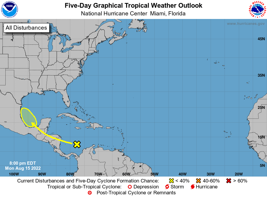
ZCZC MIATWOAT ALL
TTAA00 KNHC DDHHMM
Tropical Weather Outlook
NWS National Hurricane Center Miami FL
800 PM EDT Mon Aug 15 2022
For the North Atlantic...Caribbean Sea and the Gulf of Mexico:
1. Southwestern Gulf of Mexico:
A tropical wave currently located over the central Caribbean Sea is
forecast to move across Central America and emerge over the
southwestern Gulf of Mexico, where an area of low pressure could
form by the end of this week. Some gradual development of this
system is possible thereafter as it moves slowly to the northwest or
north-northwest over the southwestern Gulf of Mexico by this
weekend.
* Formation chance through 48 hours...low...near 0 percent.
* Formation chance through 5 days...low...20 percent.
Forecaster Papin
-
Stratton20
- Posts: 4248
- Joined: Tue Feb 09, 2021 11:35 pm
- Location: College Station, Texas
- Contact:
Interesting days ahead for sure
-
TexasBreeze
- Posts: 942
- Joined: Sun Sep 26, 2010 4:46 pm
- Location: NW Houston, TX
- Contact:
Kinda surprised they lemoned it with a 20 this far out even though the gfs doesn't show much except a surge of moisture. Would be more beneficial without any development anyways.

Seems like it has growing ensemble support. The potential NNW movement is intriguing.TexasBreeze wrote: ↑Mon Aug 15, 2022 7:31 pm Kinda surprised they lemoned it with a 20 this far out even though the gfs doesn't show much except a surge of moisture. Would be more beneficial without any development anyways.

Hopefully more of Texas can enjoy this one possibly. Hoping it goes up the center of Texas.
Last edited by djmike on Mon Aug 15, 2022 7:42 pm, edited 1 time in total.
Mike
Beaumont, TX
(IH-10 & College Street)
Beaumont, TX
(IH-10 & College Street)
-
Stratton20
- Posts: 4248
- Joined: Tue Feb 09, 2021 11:35 pm
- Location: College Station, Texas
- Contact:
Cpv17 that front that the models have been showing later this week could help to create a weakness over texas, it will be interesting to see what happens in the coming days
Yeah that NNW movement got my attention too.Cpv17 wrote: ↑Mon Aug 15, 2022 7:40 pmSeems like it has growing ensemble support. The potential NNW movement is intriguing.TexasBreeze wrote: ↑Mon Aug 15, 2022 7:31 pm Kinda surprised they lemoned it with a 20 this far out even though the gfs doesn't show much except a surge of moisture. Would be more beneficial without any development anyways.
-
- Information
-
Who is online
Users browsing this forum: Ahrefs [Bot], Bing [Bot], Semrush [Bot] and 110 guests