
August 2022
-
Stratton20
- Posts: 4248
- Joined: Tue Feb 09, 2021 11:35 pm
- Location: College Station, Texas
- Contact:
Cpv17 And looking at the 500 MB height Anomaly in the GEFS, we sray in this general pattern of wet weather through the next 10+ days, the ridge stays well away from us

Where is all the rain associated with TD4? Its about to come onshore and still nothing on radar.
Mike
Beaumont, TX
(IH-10 & College Street)
Beaumont, TX
(IH-10 & College Street)
TD4 has now made landfall. With no rain on radar. Odd. Maybe thats why the RGV QPF never showed them inundated with rain. Not sure Ive ever seen a tropical system make landfall with no rain. Im sure it will change but as of right now, nothing. More like a naked swirl making landfall.
Mike
Beaumont, TX
(IH-10 & College Street)
Beaumont, TX
(IH-10 & College Street)
-
Stratton20
- Posts: 4248
- Joined: Tue Feb 09, 2021 11:35 pm
- Location: College Station, Texas
- Contact:
The reason that their wasnt much rain when PTC4 made landfall was due to upper level ridging over the NW gulf, that essentially shoved PTC 4’s moisture bubble well south into Mexico, so by the time the actual “ center” made landfall, most of the convection was already gone
Also part of the reason there was no convection with it was because it came in during diurnal minimum.
Oh wow. Thanks for the info.
Mike
Beaumont, TX
(IH-10 & College Street)
Beaumont, TX
(IH-10 & College Street)

Another case of “only in Texas…” haha

A little seabreeze, boundary, outer band, w/e around the naked swirl is moving through providing a brief shower.
Area Forecast Discussion
National Weather Service Houston/Galveston TX
354 AM CDT Sun Aug 21 2022
...New SHORT TERM, LONG TERM, AVIATION, MARINE...
.SHORT TERM...
(Today through Monday Night)
Issued at 354 AM CDT Sun Aug 21 2022
While the reasonings will be slightly different for today and to-
morrow, the bottom line is that rain chances will remain elevated
through the short-term (and likely for much of the upcoming week).
For today, we`ll be on the lookout for additional influxes of deep-
er moisture from the south (related to the landfalling/weakening
PCT4). Activity developing near Matagorda Bay this morning should
become more widespread through the afternoon with heating and per-
haps influences from leftover boundaries and/or the sea breeze. We
could still see some spots of locally heavy rain today...with the
better chances closer to the coast. And once again, despite these
increased POPs, there should be enough breaks in the clouds for a
decent warmup. Will continue to trend high temps a couple degrees
warmer than NBM for today and tomorrow.
Decreased convective activity is expected later this evening with
the loss of daytime heating, but progs of strengthening low-level
winds could translate to development of streamer showers moving N
from the Gulf. All of this looks to be feeding the moderate/heavy
rains forecast to develop across North TX/Southern Plains along a
front tonight/overnight. This activity is then expected to slowly
sag south into our CWA tomorrow (Mon) and lingering into tomorrow
night (and beyond). Depending on the location where this line be-
gins to slow down or stall over SE TX, some areas could see up to
2-3 inches of rain for tomorrow/tomorrow night. And from WPC, the
Slight Risk of Excessive Rainfall does cover much of our northern
CWA tomorrow (Day 2)...with the Marginal Risk for the rest. 41
&&
.LONG TERM...
(Tuesday through Sunday)
Issued at 354 AM CDT Sun Aug 21 2022
More rounds of showers and thunderstorms (possibly both daytime and
nighttime) can be expected through Wednesday and/or Thursday as the
trough axis persists and weak disturbances continue to move across
the area. Models are hinting that around the Thursday/Friday time
period the axis and associated deeper moisture might edge off to our
east and take the higher rain chances with it which would result in
our area getting back into mainly diurnally driven shots of rain.
Our latest forecast generally carries higher rain chances on Tuesday
and Wednesday and then lowers the numbers (especially across our
northern counties) heading on into the Thursday through Sunday time
period. There will continue to be a risk of locally heavy rainfall
for much of the week (event totals could average more than 2 to 4
inches with isolated amounts greater than 5 inches), and we`ll
probably be monitoring some area rivers, creeks and bayous.
Lower daytime high temperatures can be expected on the rainy days (Tuesday
and Wednesday and maybe on Thursday) followed by an upward trend toward
the end of the week and the start of the weekend.
42
&&
.AVIATION...
(12Z TAF Issuance)
Issued at 354 AM CDT Sun Aug 21 2022
Patchy low clouds/fog this morning will give way to another day of
widespread convective activity across much of the CWA. Activity to
start over our SW counties/near Matagorda Bay...then expanding fur-
ther inland by mid/late morning. Coverage to peak during the after-
noon with heavy rains and gusty winds possible. Storms should wane
during the evening, but we may have to include the mention of VCSH
for the overnight hours. A strengthening low/mid level flow should
support the development of streamer SHRAs heading into sunrise Mon
morning. Mon also looks to be quite unsettled as a weak front sags
into the area and acts as a focus for additional development. 41
&&
.MARINE...
Issued at 354 AM CDT Sun Aug 21 2022
Seas and onshore winds will remain elevated this morning. It is possible
that caution flags might need to be extended into tonight and possibly
into tomorrow. A weaker onshore flow and lower seas can be expected
through much of the upcoming week. There will be a daily chance of
showers and thunderstorms. Winds and seas could be locally higher in
and near any strong storms.
42
&&
.PRELIMINARY POINT TEMPS/POPS...
College Station (CLL) 95 77 90 76 / 50 30 40 60
Houston (IAH) 93 78 93 77 / 70 30 40 50
Galveston (GLS) 91 83 91 82 / 30 30 40 40
&&
I like the way i have been getting rain not all at one time varying amounts per day and not at one time giving time for it to soak in.
Finally hit the jackpot!! The squall line felt like a tropical storm!
This is really helping the drought situation - a lot!!
This is really helping the drought situation - a lot!!
- Attachments
-
So the NWS had me down for 60 and 70% chances of rain almost every day next week, I think they had me at 80% for Wednesday with last night's update. Now everything has been trimmed down to 50% all week. What the heck?
They issued flood watches all the way down to Austin, didn’t expect that the way model trends kept pushing the heaviest rain further north and east


https://twitter.com/pppapin/status/1561479456794894337Thread
See new Tweets
Conversation
Philippe Papin
@pppapin
Interesting to see a cold surge propagating up South America Amazon. These events can trigger convectively coupled Kelvin waves (#CCKWs) in NATL as outflow reaches Caribbean & main development region (#MDR).
Flow enhances convergence & vorticity in ITCZ, seen in GFS forecast.

https://twitter.com/ScottDuncanWX/statu ... 3367223296Scott Duncan
@ScottDuncanWX
Brrrrr...
Another round of Antarctic cold moving through South America.
Yes, it is winter in the Southern Hemisphere but some places dipping 10-15°C cooler than average for this time of year.
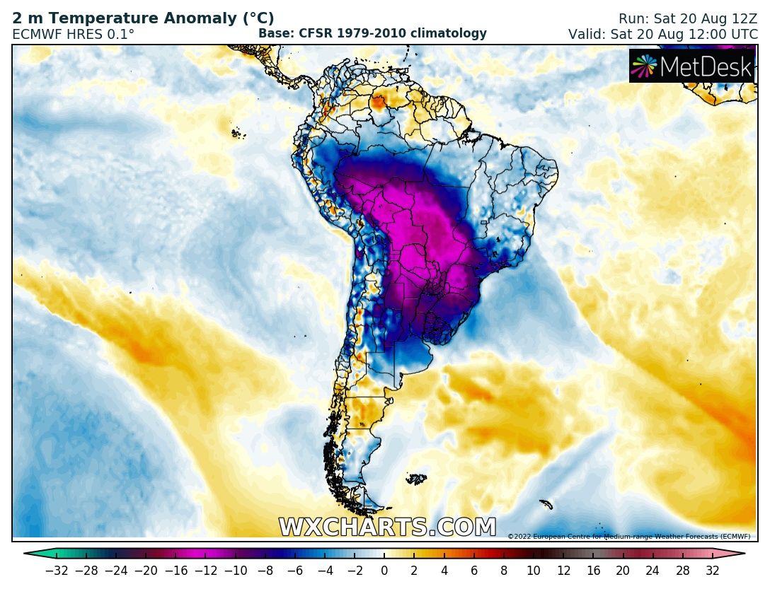
Cold air over South America is heading northward. The Convectively Coupled Kelvin Waves could help enhance tropical development.
I saw this earlier. I find that very interesting.Ptarmigan wrote: ↑Sun Aug 21, 2022 9:40 pmhttps://twitter.com/pppapin/status/1561479456794894337Thread
See new Tweets
Conversation
Philippe Papin
@pppapin
Interesting to see a cold surge propagating up South America Amazon. These events can trigger convectively coupled Kelvin waves (#CCKWs) in NATL as outflow reaches Caribbean & main development region (#MDR).
Flow enhances convergence & vorticity in ITCZ, seen in GFS forecast.
https://twitter.com/ScottDuncanWX/statu ... 3367223296Scott Duncan
@ScottDuncanWX
Brrrrr...
Another round of Antarctic cold moving through South America.
Yes, it is winter in the Southern Hemisphere but some places dipping 10-15°C cooler than average for this time of year.
Cold air over South America is heading northward. The Convectively Coupled Kelvin Waves could help enhance tropical development.
Morning email from Jeff:
Heavy rainfall threat will increase from north to south over the next 24 hours.
Impressive overnight urban flash flood event in the Dallas/Fort Worth area with 9.46 inches of rainfall in 6-hr and 7.8 inches in 3-hr. Significant flash flooding has resulted. A 1-hr storm total of 3.01 inches was recorded at DFW with a storm total of 6.54 inches which wiped out 67% of the site’s 2022 rainfall deficit in a few hours.
Frontal boundary over N TX will slowly move southward today and approach the northern portions of SE TX by mid to late afternoon. Numerous showers and thunderstorms will develop along the boundary along with scattered showers developing northward along the seabreeze and Gulf inflow. High resolution guidance is still struggling some with how the convective activity will play out over the next 48 hours. Air mass will become extremely moist and unstable with forecasted PWS of 2.2-2.6 inches and when combined with slow moving/stalled boundaries, a series of upper level disturbances in the NW flow aloft and favorable upper level flow for cell training, excessive rainfall can result. Will favor areas north of HWY 105 this afternoon for the potential for heavy rainfall then slowly sink that southward toward I-10 tonight into early Tuesday. Pattern favors slow storm motions, cell training, and backbuilding of cells to the west and northwest and this all points to heavy rainfall.
While grounds are dry, the local air mass will be capable for some impressive short duration rainfall amounts of 2-4 inches in an hour. This was clearly seen overnight in N TX and the local air mass will not be much different over SE TX, especially N of I-10. These rainfall rates can lead to rapid flash flooding especially in urban areas.
Widespread rainfall amounts of 2-4 inches is expected over much of SE TX through mid week, but isolated higher totals of 6+ inches will be possible, where these higher totals occur, flash flooding will be possible…again the greatest threat at this time looks to be north of I-10.
Confidence in rainfall is high, confidence in rainfall amounts and location of the heaviest rainfall is low.
Street flooding will be the primary threat with the heavy rainfall rates, rises on area creeks and bayou will be possible if some of the heavier storms train or move slowly over any watershed.
Overall wet pattern will linger into late week, but slightly drier air mass and washing out of the surface front should transition back toward a more “normal” cycle of showers and thunderstorms driven mostly by the seabreeze front.
I do rather hate that one rain event = drought over. The trees and crops say otherwise.
-
tireman4

- Global Moderator

- Posts: 4487
- Joined: Wed Feb 03, 2010 9:24 pm
- Location: Humble, Texas
- Contact:
XUS64 KHGX 220948
AFDHGX
Area Forecast Discussion
National Weather Service Houston/Galveston TX
448 AM CDT Mon Aug 22 2022
...New SHORT TERM, LONG TERM, AVIATION, MARINE...
.SHORT TERM...
(Today through Tuesday Night)
Issued at 448 AM CDT Mon Aug 22 2022
Not a lot of changes planned for the short-term as this wet/active
weather pattern persists. Strengthening onshore winds this morning
have started to increase streamer shower coverage across our coast-
al waters and counties...and coverage is expected expand slowly to
the north as we approach sunrise. However, the main forecast issue
for today looks to be large cluster of storms currently developing
and moving across N/NE TX along a slow-moving frontal boundary. As
this activity is still progged to sag into our CWA through the day;
and so, too, will all its associated moderate to heavy rains. Near
term guidance trends hinting that these storms will dissipate when
it reaches the I-10 corridor during the late afternoon, but probab-
ly going to carry elevated POPs into the early evening down to the
coastline. WPC is keeping a Slight Risk of Excessive Rainfall over
the northern third of the CWA on Day1, a Marginal Risk for most of
the rest. Additionally, SPC`s Day 1 did include this same northern
third of our CWA in a Marginal Risk of severe weather for this aft-
ernoon. The possibility of a meso low developing along the frontal
boundary could produce some strong/severe thunderstorms capable of
strong damaging winds/gusts. Enhanced rainfall rates up to 2"/hour
will also be possible with the heavier downpours. Not going with a
Flood Watch for today at this time as rainfall totals so far these
last couple of days have been a bit less then expected.
A bit of a break in the activity progged for this evening, but the
chances for rain will be going up once again overnight (into early
Tues morning) in and near the vicinity of the frontal boundary. We
may have to consider Flood Watches at this point...again depending
on how much rain falls today. WPC is keeping the northern portions
of the CWA (generally north of I-10) in a Slight Risk of Excessive
Rain tomorrow (Tues) as the boundary lingers over the region, with
the focus for heavy rains shifting into the Houston Metro. Not too
confident that we`ll see widespread heavy rains, but even the more
localized storms with high rain rates are going to cause problems,
especially in low-lying, urban, and other poor drainage spots. 41
&&
.LONG TERM...
(Wednesday through Monday)
Issued at 448 AM CDT Mon Aug 22 2022
Still looking for periods of showers and thunderstorms for the second
half of the week with a nearly stationary surface boundary in/around
the area. The higher/best rain chances look like they might end up eventually
setting up across our central and southern counties and areas off to
our east into Louisiana on Wednesday. Locally heavy rainfall will be
possible once again. Will indicate slightly lower rain chances heading
into Thursday and Friday as some drier air tries to edge into the area
from the north (do not think it will get too far south), and will lead
toward a more diurnal pattern over the weekend and on into the start
of next week. The rain and clouds should keep high temperatures under
90 degrees on both Wednesday and Thursday, and will indicate gradually
warming temperatures at the end of the week and over the weekend.
42
&&
.AVIATION...
(12Z TAF Amendment)
Issued at 448 AM CDT Mon Aug 22 2022
Streamer activity over the coastal waters overnight are starting to
slowly make their way inland this morning. We should see this trend
continue into the mid/late morning and could have impacts on south-
ern most terminals. Further north, we`ll be dealing with the slowly
sagging frontal boundary and its associated storms by the afternoon.
Confidence remains low in terms of timing and storm coverage given
model inconsistencies. Nearterm guidance is continuing to suggest a
slower solution with convection decreasing rapidly when it approach-
es the I-10 corridor. But will likely keep at least a mention of VC
SH/TS in for most sites through sunset. 41
&&
.MARINE...
Issued at 448 AM CDT Mon Aug 22 2022
Fresh to moderate onshore flow will persist through most of the week.
An approaching weak front will stall across Southeast Texas and will
increase the chances for showers and storms each day for our coastal
waters. The effects of this front will move out on Saturday and rain
chances return to a more normal summer pattern by the weekend.
42
&&
.PRELIMINARY POINT TEMPS/POPS...
College Station (CLL) 96 75 90 74 / 50 60 70 50
Houston (IAH) 95 77 89 76 / 40 40 60 50
Galveston (GLS) 92 82 90 80 / 30 20 60 50
&&
.HGX WATCHES/WARNINGS/ADVISORIES...
TX...None.
GM...None.
&&
$$