August 2022
-
Stratton20
- Posts: 5430
- Joined: Tue Feb 09, 2021 11:35 pm
- Location: College Station, Texas
- Contact:
It might just be me but I feel like the GFS has not been very reliable this year, it has done an absolutely horrific job with the tropics this season, i am skeptical of any thing that the GFS shows lol
Agreed on the GFS. What a disaster in the tropics so far.
-
Stratton20
- Posts: 5430
- Joined: Tue Feb 09, 2021 11:35 pm
- Location: College Station, Texas
- Contact:
mcheer23 they must be buying into the euro and cmc solutions
With the WPC I’ve noticed that they tend to start out on the conservative side and tend to bump up the totals as the event draws closer as long as there’s good confidence in the forecast.
A micro cell just dumped a quick .60 of rain on me in just 10 minutes  LOL
LOL
- tireman4
- Global Moderator

- Posts: 6258
- Joined: Wed Feb 03, 2010 9:24 pm
- Location: Humble, Texas
- Contact:
&&
.AVIATION...
(18Z TAF Issuance)
Issued at 1243 PM CDT Wed Aug 31 2022
Even with the storms developing along the sea and bay breezes at
this time, coverage so far today has been limited. Subsidence at
the mid/upper levels appear to be winning out, but not confident
enough to completely drop the mention of VCTS for inland termin-
als for the rest of this afternoon. Activity should decrease by/
near sunset once again with the loss of daytime heating. However
there are some concerns regarding rain chances for our northern-
most sites as overnight convection across North/Central TX could
push a few outflows our way. Winds should remain light (5-10 kts)
from the E/SE during the day and variable at night. 41
-
Stratton20
- Posts: 5430
- Joined: Tue Feb 09, 2021 11:35 pm
- Location: College Station, Texas
- Contact:
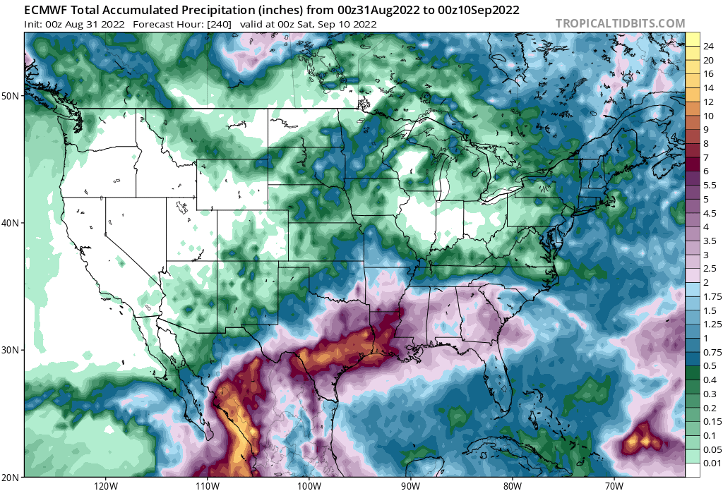
Well the 12z Euro hust pulled an Uno reverse card on the EPAC moisture lol
Yeah lol lots of time for that to play out though.Stratton20 wrote: ↑Wed Aug 31, 2022 2:14 pm Well the 12z Euro hust pulled an Uno reverse card on the EPAC moisture lol
-
mcheer23
- Global Moderator

- Posts: 594
- Joined: Fri Jan 11, 2013 11:15 am
- Location: Missouri City/ Sugar Land
- Contact:
Very dependent on where the future tropical cyclone hits…Stratton20 wrote: ↑Wed Aug 31, 2022 2:14 pm Well the 12z Euro hust pulled an Uno reverse card on the EPAC moisture lol
Yep. Lots of time to watch that play out. Regardless it still looks like good rain chances continue through next week.mcheer23 wrote: ↑Wed Aug 31, 2022 2:48 pmVery dependent on where the future tropical cyclone hits…Stratton20 wrote: ↑Wed Aug 31, 2022 2:14 pm Well the 12z Euro hust pulled an Uno reverse card on the EPAC moisture lol
-
Stratton20
- Posts: 5430
- Joined: Tue Feb 09, 2021 11:35 pm
- Location: College Station, Texas
- Contact:
-
TexasBreeze
- Posts: 1012
- Joined: Sun Sep 26, 2010 4:46 pm
- Location: NW Houston, TX
- Contact:
I was just wondering that about your area jason- another hole just like my brother in San Antonio everyday! Looked north and the clouds looked good earlier, then broke up and moved along.
They have it a lot worse than I do so I am very grateful for what I’ve gotten, regardless of my public venting of the constant donut fest.TexasBreeze wrote: ↑Wed Aug 31, 2022 5:46 pm I was just wondering that about your area jason- another hole just like my brother in San Antonio everyday! Looked north and the clouds looked good earlier, then broke up and moved along.
It will all even out some day. Hopefully it doesn’t come all at once hehe.
Fall must be approaching. The hummingbirds are back in my yard.
-
Stratton20
- Posts: 5430
- Joined: Tue Feb 09, 2021 11:35 pm
- Location: College Station, Texas
- Contact:
00z GFS looks very wet over the next 10 days while the 00z CMC tracks the DPAC systems mositure right over Se Texas, QPF map is still loading for the CMC but I bet it will show some big totals
….annnnnd on to the September thread. See ya there!
Mike
Beaumont, TX
(IH-10 & College Street)
Beaumont, TX
(IH-10 & College Street)
-
- Information
-
Who is online
Users browsing this forum: Ahrefs [Bot], Bing [Bot], Stratton20 and 23 guests
