Page 53 of 55
Re: August 2022
Posted: Tue Aug 30, 2022 3:33 pm
by Cpv17
Stratton20 wrote: ↑Tue Aug 30, 2022 3:18 pm
Cpv17 why can those be dangerous?
Edit: I see what you mean, Euro brings in a WPAC system at the ends of its run into the state and has some pretty big totals
They have a lot of history of bringing flooding rains to the state.
The CPC seems to think we’ll stay wet into the second week of September.
Re: August 2022
Posted: Tue Aug 30, 2022 3:38 pm
by DoctorMu
Cpv17 wrote: ↑Tue Aug 30, 2022 3:33 pm
Stratton20 wrote: ↑Tue Aug 30, 2022 3:18 pm
Cpv17 why can those be dangerous?
Edit: I see what you mean, Euro brings in a WPAC system at the ends of its run into the state and has some pretty big totals
They have a lot of history of bringing flooding rains to the state.
The CPC seems to think we’ll stay wet into the second week of September.
October 1994. We had 18 inches of rain in 18 hours in CLL.
I kick down part of a fence to let water out of the backyard.
Re: August 2022
Posted: Tue Aug 30, 2022 3:38 pm
by srainhoutx
 Viewed 5996 times")
Mesoscale Precipitation Discussion 0909
NWS Weather Prediction Center College Park MD
401 PM EDT Tue Aug 30 2022
Areas affected...Southeast TX
Concerning...Heavy rainfall...Flash flooding possible
Valid 302000Z - 310000Z
SUMMARY...Ongoing thunderstorm activity across southeast Texas may
result in additional flash flooding through late afternoon.
DISCUSSION...A 500mb low over West Texas is providing some
diffluent flow aloft while 850mb winds continue to funnel rich
Gulf of Mexico moisture into southeast Texas. This is in part due
to a 500mb ridge along the central Louisiana coast, that in tandem
with the upper low in West Texas, is resulting in a convergence
zone over southeast Texas. 19Z surface analysis showed a surface
low in central Texas with a pair of surface troughs acting as
triggers for ongoing areas of convection. SPC RAP mesoanalysis
showed a reservoir of 2.2-2.3" PWs throughout the highlighted
region, as well as MLCAPE between 1,000-2,000 J/kg. 850-300mb mean
wind speeds are ~5 knots and mean cloud layer RH values are
averaging close to 90%.
Ongoing storms have begun to propagate west towards central Texas
where one surface trough is located while storms continue to form
along another surface trough west of Houston. 17Z HRRR showed
storms gradually dissipating around 00Z with the atmosphere being
overworked and due to the loss of daytime heating. However, storms
associated outflow boundaries may help to produce additional
storms not long after sunset. The 12Z HREF displayed probabilities
of 3-hr QPF > 3-hr FFGs as high as 45-50% west of Kileen. FLASH
CREST max unit stream flow highlighted Kileen as seeing 300-700
cfs/smi due to storms recently passing through the area. MRMS
instantaneous precip rates were as high as 4-5"/hr in some cases,
but most areas can expect hourly rainfall totals in the 2-3"/hr
range. This shows the type of rapid onset flooding that can occur,
especially in urbanized communities that contain a greater
concentration of hydrophobic surfaces. Low lying, poor drainage
areas are also susceptible to flash flooding the remainder of the
afternoon.
Mullinax
ATTN...WFO...CRP...EWX...FWD...HGX...SJT...
Re: August 2022
Posted: Tue Aug 30, 2022 3:40 pm
by DoctorMu
Yep. Feast or Famine.

Re: August 2022
Posted: Tue Aug 30, 2022 4:12 pm
by jasons2k
The line to the west is starting to advance, with an outflow of course, but should get some more juice out of it.
Edit 3:58. Outflow blew by. The stuff west of here may start dying.
And look to my northeast already. This has the looks of another ‘skip’ look to it. Maybe a few frames later it can blossom here too…
Edit 4:03 the skies to my NE are super dark blue with a blue-turquoise rain shaft. Beauty from afar…
Radar is lighting up around me though.
Re: August 2022
Posted: Tue Aug 30, 2022 4:36 pm
by jasons2k
4:12 sure hope this donut fills-in before everything falls apart. Lots of thunder to my NE. Wrong effing direction, again.
Re: August 2022
Posted: Tue Aug 30, 2022 4:59 pm
by jasons2k
Yep, once again….
Re: August 2022
Posted: Tue Aug 30, 2022 6:19 pm
by DoctorMu
jasons2k wrote: ↑Tue Aug 30, 2022 4:59 pm
Yep, once again….
Any Aggies recently settle into the area, recently? Because that is one helluva AggieDome. I can't believe those cells moving just west of I-45 missed you.
1.72 in of rain today in CLL. Salvation at last. Now I can begin preparations for brown patch season.

Re: August 2022
Posted: Tue Aug 30, 2022 6:21 pm
by DoctorMu
jasons2k wrote: ↑Tue Aug 30, 2022 4:59 pm
Yep, once again….
https://youtu.be/eV67FuREdSc
Re: August 2022
Posted: Tue Aug 30, 2022 6:27 pm
by jasons2k
DoctorMu wrote: ↑Tue Aug 30, 2022 6:19 pm
jasons2k wrote: ↑Tue Aug 30, 2022 4:59 pm
Yep, once again….
Any Aggies recently settle into the area, recently? Because that is one helluva AggieDome. I can't believe those cells moving just west of I-45 missed you.
1.72 in of rain today in CLL. Salvation at last. Now I can begin preparations for brown patch season.
I’m glad you finally hit the jackpot!
Yeah, every cell that approached me today fell apart, no matter which direction. And then another would reform on the other side of me.
My step-mother and sister moved here back in May. They asked me last week "What is up with the rain in this area? It's like this one neighborhood has a forcefield over it that just zaps anything headed this way"
I said "Basically, yep - welcome to the neighborhood!"
Re: August 2022
Posted: Tue Aug 30, 2022 6:32 pm
by Cpv17
jasons2k wrote: ↑Tue Aug 30, 2022 6:27 pm
DoctorMu wrote: ↑Tue Aug 30, 2022 6:19 pm
jasons2k wrote: ↑Tue Aug 30, 2022 4:59 pm
Yep, once again….
Any Aggies recently settle into the area, recently? Because that is one helluva AggieDome. I can't believe those cells moving just west of I-45 missed you.
1.72 in of rain today in CLL. Salvation at last. Now I can begin preparations for brown patch season.
I’m glad you finally hit the jackpot!
Yeah, every cell that approached me today fell apart, no matter which direction. And then another would reform on the other side of me.
My step-mother and sister moved here back in May. They asked me last week "What is up with the rain in this area? It's like this one neighborhood has a forcefield over it that just zaps anything headed this way"
I said "Basically, yep - welcome to the neighborhood!"
Outta all the people on here it seems like you get the shaft more than anyone else.
Re: August 2022
Posted: Tue Aug 30, 2022 8:43 pm
by 869MB
Cpv17 wrote: ↑Tue Aug 30, 2022 6:32 pm
jasons2k wrote: ↑Tue Aug 30, 2022 6:27 pm
DoctorMu wrote: ↑Tue Aug 30, 2022 6:19 pm
Any Aggies recently settle into the area, recently? Because that is one helluva AggieDome. I can't believe those cells moving just west of I-45 missed you.
1.72 in of rain today in CLL. Salvation at last. Now I can begin preparations for brown patch season.
I’m glad you finally hit the jackpot!
Yeah, every cell that approached me today fell apart, no matter which direction. And then another would reform on the other side of me.
My step-mother and sister moved here back in May. They asked me last week "What is up with the rain in this area? It's like this one neighborhood has a forcefield over it that just zaps anything headed this way"
I said "Basically, yep - welcome to the neighborhood!"
Outta all the people on here it seems like you get the shaft more than anyone else.
Not to steal Jason’s thunder, but I was actually Jason before Krispy Crème found his neighborhood. Jason himself can vouch for me with my constant near misses and donut holes here in Katy over the years, so I’ve already lived it. Fortunately, rainfall chances appear promising for everyone concerned. In fact, a few people may see excessive rainfall amounts over the forthcoming weeks, even Jason’s neighborhood believe it or not.
Re: August 2022
Posted: Tue Aug 30, 2022 11:54 pm
by Stratton20
We need to monitor next week for potential moisture/heavy rain from an WEPAC system crossing into the state, the euro is showing this and the 00z CMC is too at hour 210, has some pretty big totals
Re: August 2022
Posted: Wed Aug 31, 2022 1:49 am
by walsean1
Stratton20 wrote: ↑Tue Aug 30, 2022 11:54 pm
We need to monitor next week for potential moisture/heavy rain from an WEPAC system crossing into the state, the euro is showing this and the 00z CMC is too at hour 210, has some pretty big totals
I noticed that our chances for rain high for the Saturday/Sunday/ Monday timeframe according to ABC 13 David Tillman. Would this be in line with what you are seeing for next week?
Re: August 2022
Posted: Wed Aug 31, 2022 3:52 am
by Pas_Bon
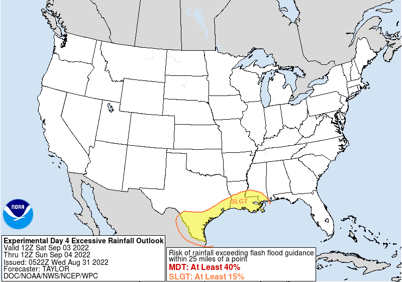
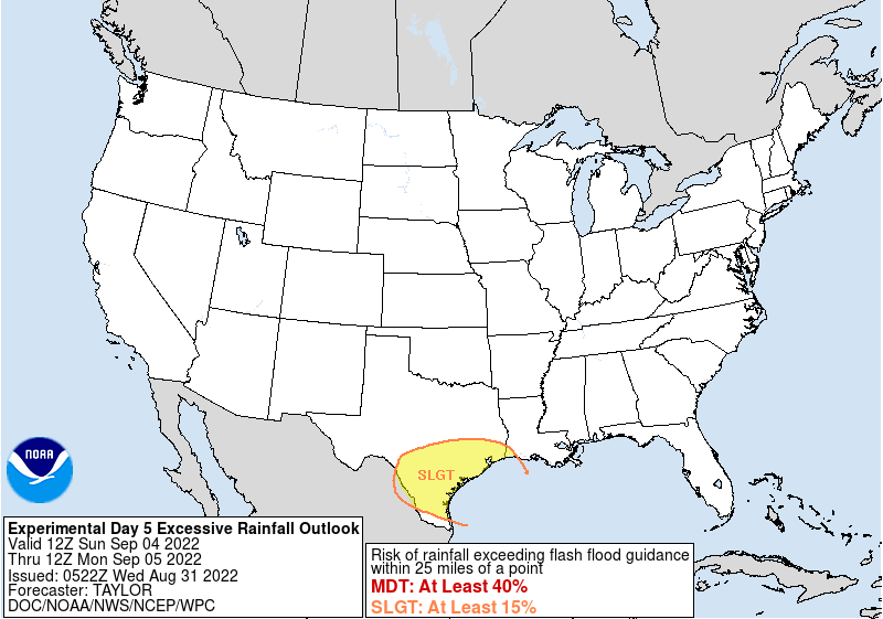
We all need to be on the lookout for at least a localized flooding event on Saturday. I’m growing somewhat concerned about the synoptic pattern being forecast. Eyes and ears peeled, folks….
Re: August 2022
Posted: Wed Aug 31, 2022 8:12 am
by tireman4
XUS64 KHGX 311145
AFDHGX
Area Forecast Discussion
National Weather Service Houston/Galveston TX
645 AM CDT Wed Aug 31 2022
...New AVIATION...
.SHORT TERM...
(Today through Thursday Night)
Issued at 416 AM CDT Wed Aug 31 2022
As of 3 AM, GOES 16 Water Vapor Imagery shows the upper level low
located along the region of southeastern New Mexico and western
Texas. The low will continue to progress west-southwest towards the
Baja California area through Thursday as a weak upper level trough
moves into the Great Plains. Thus, for today, we will probably have
a bit less influence from the low and chances of rain will be
slightly lower. Winds will be more east to southeasterly this
morning, but plenty of low level moisture remains across the region
with TPWs of 2.0 to 2.2 currently over Southeastern Texas.
Therefore, a few showers will be possible during the morning hours,
followed be the typical summer pattern of showers and thunderstorms
developing during the afternoon hours as onshore flow returns and
daytime heating peaks, dissipating in the evening.
Chance of rain will be a bit higher on Thursday with activity
starting to fire up during the morning as the upper level trough
digs into the Texas Panhandle. As the trough moves across Northern
Texas during the day, conditions for shower and thunderstorm
development will improve. In addition, there is a chance we could
have storms that developed along North and Northeast Texas move
through the area through the late evening or early night hours. But
we will have to wait and see how these develop to get a better idea
of how strong they will be by the time they arrive our local area.
For now, the Hi-Res/CAMs are a little varied on the evolution and
path of these storms, so in this forecast package, have kept just
slight chance of rain (15-30%) for Thursday night.
The maximum temperatures today will be warmer with highs in the low
to mid 90s areawide. The lows overnight will also be a tad bit
warmer with lows in the mid to upper 70s for inland portions and in
the upper 70s to low 80s along the coasts. Depending on rain and
cloud coverage, the highs on Thursday could be similar to today`s
but areas that receive more rain could have highs a degree or two
lower.
24
&&
.LONG TERM...
(Friday through Tuesday)
Issued at 416 AM CDT Wed Aug 31 2022
Unsettled weather is expected through Labor Day and into early next
week with scattered to widespread showers and thunderstorms.
Southeast TX will be positioned between a strong upper-lvl ridge
over the Southwestern CONUS and a building ridge across the western
Atlantic/Southeastern CONUS. A cutoff low will develop between these
strong ridges, moving east-southeast across the South
Plains/ArkLaTex region. In addition, deep tropical moisture
associated with a weak disturbance over the southwestern Gulf will
continue to surge northward across the region. Decent forcing
associated with this passing trough/cutoff low and abundant
warm/moist southerly sfc flow will increase rain and thunderstorm
chances on Friday.
The probability of precipitation progressively increases Friday night
into early next week as a backdoor frontal boundary moves through
and becomes quasi-stationary along the coast. Global models still
differ on the evolution and strength of some mesoscale features;
however, models keep suggesting an increase in moisture with PWATS
around 2.3-2.5 inches through early next week. These values are
well above normal (above the median moving average) for late
August standards; suggesting locally moderate to heavy rain,
particularly along the boundary. Have increased PoPs to 50-70
percent mainly for Saturday and Sunday with the best chances south
of I-10.
Rain and storm chances Monday through Wednesday will generally
revolve around the the quasi-stationary boundary meandering along
the coast and slowly moving inland/northward.
&&
.AVIATION...
(12Z TAF Issuance)
Issued at 634 AM CDT Wed Aug 31 2022
VFR conditions currently across SE Texas sites with light VRB
winds. Areas of SH/TS expected today as an upper level low over
NE New Mexico and W Texas progresses SW. Winds will turn E-SE this
aft at 8 KTS or less, and become light and VRB again in the late
evening. Slightly higher chances of SH/TS expected Thu as a weak
upper level trough moves into the Texas Panhandle; activity could
begin to affect CLL/UTS/CXO region by early Thu morning.
24
&&
.MARINE...
Issued at 416 AM CDT Wed Aug 31 2022
Isolated showers and thunderstorms are expected each day, with the
best chances Friday night into the weekend as a frontal boundary
moves through and stalls along the coast. Seas and winds may
increase at times, especially near any stronger thunderstorms.
&&
.PRELIMINARY POINT TEMPS/POPS...
College Station (CLL) 94 75 93 75 / 40 30 60 40
Houston (IAH) 94 77 94 76 / 50 30 50 20
Galveston (GLS) 91 81 91 81 / 40 30 30 30
&&
.HGX WATCHES/WARNINGS/ADVISORIES...
TX...None.
GM...None.
&&
$$
Re: August 2022
Posted: Wed Aug 31, 2022 8:19 am
by Cpv17
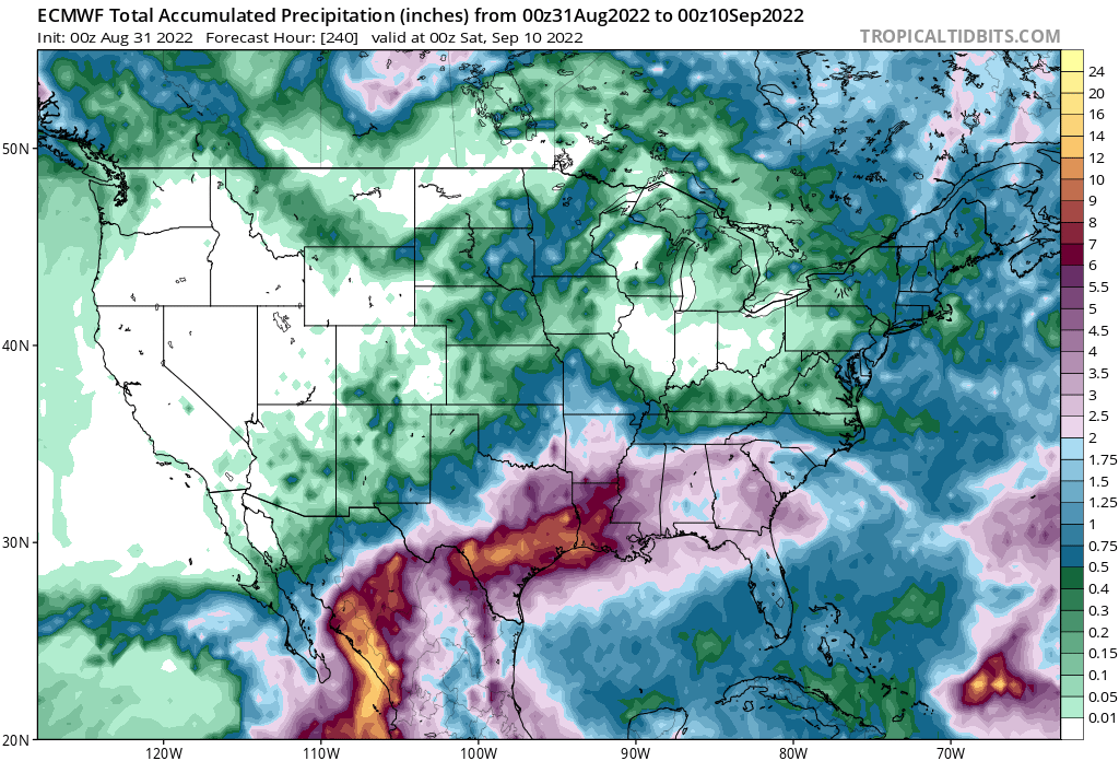
Saturday:
Sunday:
Re: August 2022
Posted: Wed Aug 31, 2022 8:54 am
by Cromagnum
Looks like I'm taking rain coats to Cynthia Woods...
Re: August 2022
Posted: Wed Aug 31, 2022 9:00 am
by Stratton20
Hopefully all the rain stays south of me on saturday, im gonna be pissed if the first game gets rained out lol
Re: August 2022
Posted: Wed Aug 31, 2022 9:15 am
by Cpv17
0z Euro rain totals the next 10 days: