Stratton20 wrote: ↑Tue Sep 13, 2022 11:55 am
Might have to watch that wave that will approaching the leeward islands in a few days, the CMC brings it into the gulf and the. forced west as ridging builds in to the north, something to watch
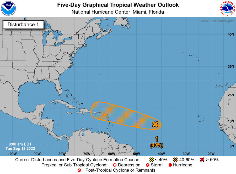
The NHC has tagged that wave and designated it as 96L giving it a 40% chance of development.
1. Central Tropical Atlantic:
Conventional and Low-earth orbit satellite data indicate that
showers and thunderstorms associated with a tropical wave located
about midway between the west coast of Africa and the Windward
Islands have increased and become better organized since yesterday
afternoon. Further development of this system is possible and a
tropical depression could form over the next several days while it
generally moves westward to west-northwestward over the central
tropical Atlantic and approaches the Leeward Islands on Friday.
* Formation chance through 48 hours...low...30 percent.
* Formation chance through 5 days...medium...40 percent.
Stratton20 wrote: ↑Tue Sep 13, 2022 11:55 am
Might have to watch that wave that will approaching the leeward islands in a few days, the CMC brings it into the gulf and the. forced west as ridging builds in to the north, something to watch
Yeah i saw that the CMC stops at hour 240 with it heading due west with high pressure sitting over it a slow season can tend to lull us into a false sense of security we need to stay vigilant.
12z GFS with a Cat 4 getting somewhat close to the East US Coast while the 12z CMC has a major cat 3 963 mb hurricane in the western gulf, lots of time to watch
57 says we have nothing to worry about and doesn’t even think it’s a depression right now and probably won’t develop till it turns north and goes out to sea. Not that I’m really believing that though, cuz I’m not. If it goes into the Hispaniola shredder, decent chance it stays weak and moves further west.
Area Forecast Discussion
National Weather Service Houston/Galveston TX
1227 PM CDT Wed Sep 14 2022
...New AVIATION...
.SHORT TERM...
(Today through Thursday Night)
Issued at 338 AM CDT Wed Sep 14 2022
Satellite imagery is showing some patchy for and/or low clouds,
mainly to the west and southwest of Houston, the only blemishes on
a clear Southeast Texas sky early this morning. With dewpoints
largely in the lower to middle 60s, temperatures have gotten
pretty nice if you`ve grown tired of warm summer nights, falling
just below 70 degrees. Though we should have a bit of a cooler
start this morning, the drier air in place will also heat more
effectively today, so highs are still in the lower half of the 90s
inland, and in the upper 80s at the coast.
This small amuse bouche of fall is, well...just that...merely a
brief taste before we return back to a more summer-like pattern
tomorrow. As high pressure to our east/northeast becomes more
prominent later today and tonight, onshore flow will become more
established, beginning to bring back the summery, Gulf airmass to
the area. We`ll just be getting started, so low temperatures
tonight will still be a bit on the cool side, at least away from
the immediate coast, which is likely to get hung up in the 70s
already.
Precipitable water values this morning remain in the 50-75 percent
of normal range, and it`s probably no surprise that rain chances
today look quite slim. If there`s rain to be seen anywhere, I`d
look to the Gulf waters off Matagorda Bay, and perhaps scraping on
the coast a little bit...and that might be a generous reading of
things.
Once that onshore flow gets more established, we can expect to see
deeper moisture advect into the region - and though we discussed
this in terms of low temps by tomorrow morning, we can also expect
enough moisture to work in that we`ll see potential for some late
night/early morning streamer showers at the coast, gradually
becoming some chances for showers and thunderstorms on the coastal
plain southwest of Houston.
Luchs
&&
.LONG TERM...
(Friday through Tuesday)
Issued at 338 AM CDT Wed Sep 14 2022
There have been no meaningful changes to the forecast in the
extended range. Continued east to east-southeast flow is expected to
advect higher low level moisture from the Gulf into southeast Texas
on Friday into the weekend. PW values of 20-40% above normal coupled
with diurnal/mesoscale forces will increase the chance of
showers/storms, particularly during the afternoon hours. The best
chance of rain will be over the southern half of our CWA. However,
the chance of isolated to scattered showers/storms in our northern
counties has trended upward in recent updates. High temperatures are
expected to range from the upper 80s near the coast to low/mid 90s
in inland areas. Overnight lows will generally be in the 70s.
The amount of diurnal shower/thunderstorm activity that lingers into
early next week will depend on the position of a mid/upper level
ridge. A ridge axis that builds over the central US would increase
pressure heights over the region and may entail the introduction of
mid level dry air. Such a pattern would tend to suppress convection.
Our forecast hints at this possibility with a downward trend in the
PoPs early next week. However, we still indicate a chance of
afternoon showers/storms during the Monday-Tuesday time frame,
especially south of I-10, since a farther east orientation in the
ridge axis is also possible.
No major changes to the forecast with VFR conditions prevailing
and east to southeast winds reaching around 10 knots today before
becoming lighter overnight. Tomorrow, shower activity will
increase near the coast and as a result have added VCSH wording to
GLS/LBX TAFs for late tomorrow morning. Otherwise, cloud cover
should remain fairly limited and no cig/vis concerns are expected.
Cady
&&
.MARINE...
Issued at 338 AM CDT Wed Sep 14 2022
Light to moderate east to east-southeast winds and generally 2 to 4
foot seas are expected through the end of the week. During the
second half of the week, there will be an increasing chance of
isolated to scattered showers and thunderstorms. Winds and seas
could be locally higher in and near stronger thunderstorms.
Not so fast, there still is alot of uncertainty and besides its still a very lopsided system, the center is well displaced to the West of of all the convection, dont think it will strengthen much when the MLC and LLC are misaligned that much, their is still a pretty huge spread in the EPS and GEPS guidance, ranging from OTC, near the east coast or into the GOM, its still a sloppy system and its structure is not great, I think we will see a center relocation to the SE and a slight shift southward in the track
Edit: Here is the 06z EPS, a significant spread remains
CMC is on board with the Euro and GFS eastern solutions now. Besides Ike, have we ever had one this far north "shoot the gap" between Florida and Hispaniola and come our way? I know some have certainly tried it, but then turned north into Florida or Alabama.
Cromagnum no the CMC has not trended toward the euro and gfs, its sticking to its guns, still has fiona missing the weakness, ridge builds in and gets shoves fiona into the GOM, their still are alot of variables at play here, cant write it off yet