
September 2022

14 ft storm surge reported in Ft. Myers
-
tireman4

- Global Moderator

- Posts: 4958
- Joined: Wed Feb 03, 2010 9:24 pm
- Location: Humble, Texas
- Contact:
I have a bad feeling about this. It is going ever so slowly and bringing wind, rain and surge on top of that.
From the recon flight earlier today..
When I say this was the roughest flight of my career so far, I mean it. I have never seen the bunks come out like that. There was coffee everywhere. I have never felt such lateral motion. Aboard Kermit (#NOAA42) this morning into Hurricane #Ian. Please stay safe out there. https://t.co/DQwqBwAE6v pic.twitter.com/gvV7WUJ6aS
-- Tropical Nick Underwood (@TheAstroNick) September 28, 2022
Once the backside of the eyewall starts coming in its really going to tear things up.
-
Stratton20
- Posts: 4682
- Joined: Tue Feb 09, 2021 11:35 pm
- Location: College Station, Texas
- Contact:
Its going to get even worse, strongest winds are on the western side of the eye wall…… Has yet to pass over
We have landfall now.DoctorMu wrote: ↑Wed Sep 28, 2022 10:39 amPort Charlotte is going to be crushed. PC and Englewood could be in the eyewall for hours.tireman4 wrote: ↑Wed Sep 28, 2022 9:59 am From Wxman 57 on S2K..
Note that the NHC's 12-16 ft surge into Port Charlotte/Ft. Myers is for the BEACH. Surge up the Caloosahatchee river into Ft. Myers could be 20-24 ft. See the NHC's inundation graphic for the region. MANY areas under 9+ ft of water this afternoon. Far as I can tell, this will be the worst hurricane ever to strike the area. Charley in 2004 was strong, but tiny compared to Ian. Ian will be retired.
I hope everyone GTFO.
Houses will be covered and lifted away by the water. Ft. Myers, Sanibel, other barrier islands.
-
tireman4
- Global Moderator
- Posts: 4958
- Joined: Wed Feb 03, 2010 9:24 pm
- Location: Humble, Texas
- Contact:
Hurricane #Ian makes landfall with 150 mph winds at Cayo Costa, Florida, the exact spot Category 4 Charley made landfall in 2004, also with 150 mph. About where the comparisons end. Ian with an enormous footprint of water that's only just begun. pic.twitter.com/ACn5CKaaW9
-- Michael Lowry (@MichaelRLowry) September 28, 2022
-- Michael Lowry (@MichaelRLowry) September 28, 2022
Enjoy this lower humidity and cool mornings while it lasts. Looks like a torch is coming after this.
-
Stratton20
- Posts: 4682
- Joined: Tue Feb 09, 2021 11:35 pm
- Location: College Station, Texas
- Contact:
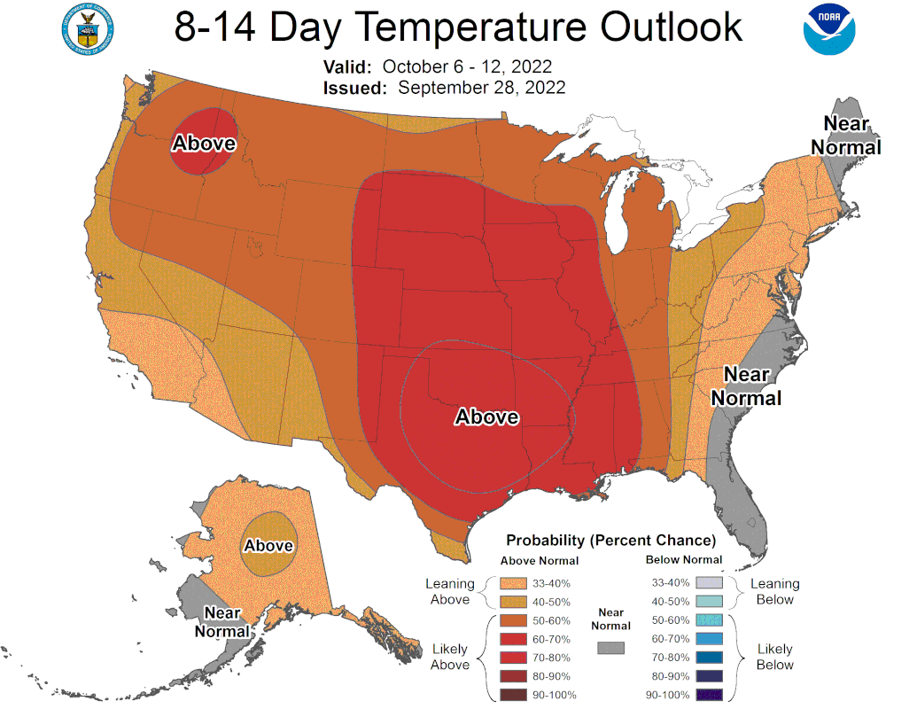
Cpv17 maybe some low 90’s, but we are done with the extreme stuff, the NHC has around 90 degrees as our hottest temperature here over the next 10 days with lows in the 60’s, second summer is over and a slow transition to fall is beginning
-
tireman4
- Global Moderator
- Posts: 4958
- Joined: Wed Feb 03, 2010 9:24 pm
- Location: Humble, Texas
- Contact:
.AVIATION...
(18Z TAF Issuance)
Issued at 1220 PM CDT Wed Sep 28 2022
Mainly a wind forecast as dry air continues to prevail. Easterly
winds this morning will gradually shift over to northeasterly by
the afternoon. Additionally, wind gusts up to 15-20 knots are
possible through the afternoon hours as a low-level jet streak
passes near the region. Winds become light and variable overnight
again and becomes northeasterly again around 10 knots on Thursday
morning.
Batiste
Stratton20 wrote: ↑Wed Sep 28, 2022 3:49 pm Cpv17 maybe some low 90’s, but we are done with the extreme stuff, the NHC has around 90 degrees as our hottest temperature here over the next 10 days with lows in the 60’s, second summer is over and a slow transition to fall is beginning
I have a feeling this might last into December.
-
Stratton20
- Posts: 4682
- Joined: Tue Feb 09, 2021 11:35 pm
- Location: College Station, Texas
- Contact:
Cpv17 seems likes its always above normal until december lol, cant remember the last time seeing a below normal fall, hopefully we can get a few fall fronts to come down from time to time though
Last year on Christmas I was wearing shorts and a t-shirt. Ridiculous.Stratton20 wrote: ↑Wed Sep 28, 2022 4:35 pm Cpv17 seems likes its always above normal until december lol, cant remember the last time seeing a below normal fall, hopefully we can get a few fall fronts to come down from time to time though
Yep same here. It's a total buzz kill. I just don't have it in me to associate Christmas with shorts, t-shirts, A/C blowing and sweating while cooking inside.Cpv17 wrote: ↑Wed Sep 28, 2022 4:37 pmLast year on Christmas I was wearing shorts and a t-shirt. Ridiculous.Stratton20 wrote: ↑Wed Sep 28, 2022 4:35 pm Cpv17 seems likes its always above normal until december lol, cant remember the last time seeing a below normal fall, hopefully we can get a few fall fronts to come down from time to time though
Pretty quiet hurricane season overall but all it takes is one good storm to be a memorable season.DoctorMu wrote: ↑Wed Sep 28, 2022 5:14 pm Holy **** at the storm surge in Punta Gorda.
https://twitter.com/IanFootage/status/1 ... lwG63NkJTg

Crazy to see all the rain and storms in the west side of Ian. The NE quadrant is just about void of any rain.
Mike
Beaumont, TX
(IH-10 & College Street)
Beaumont, TX
(IH-10 & College Street)
Yes - Very unusual. I noticed the Gov. declared victory before the backside leveled the pimp hand.
Never mess with mother nature.
Cantore was absolutely exhausted from half a day in the eyewall. I feel badly for the Ft. Myers area, but fortunately Ian did not strike a more heavily populated area - Tampa/St. Pete/Sarasota or Miami-Dade.
It's like half a hurricane on radar. There is absolutely nothing east, southeast, our south of the circulation.

Ian is a storm that will be studied for a long time. Since this morning, this cyclone has been slowly transitioning to a sub-tropical cyclone. It started to ingest dry air and you saw the uncharacteristically updrafts and downdrafts with intense lightning along with the Hurricane Hunters and their hail reports (and coffee spills). That is not typical for the incredible number of missions they have completed. Ian has been attached to a frontal trough with outflow and moisture being stripped to the NE. This is not your stand-alone, true tropical cyclone. For me, all the lightning and hail signaled a storm that was giving a very violent 'last gasp' - but would then start to fall part quickly after landfall and the dry air started to wrap around. That seems to be happening now - another 'half hurricane' - but in Florida. I look forward to the lessons that will be learned from Ian.


I wonder if Hurricane Ian will be upgraded to Category 5.
-
- Information
-
Who is online
Users browsing this forum: Ahrefs [Bot], Cpv17, Semrush [Bot] and 12 guests