April 2023
-
Stratton20
- Posts: 4248
- Joined: Tue Feb 09, 2021 11:35 pm
- Location: College Station, Texas
- Contact:
12z GFS has about 6-8 inches for me, wow lol
-
Iceresistance
- Posts: 577
- Joined: Fri Apr 30, 2021 11:48 pm
- Location: Tecumseh, OK
- Contact:
Imagine the models are pulling the April Fools joke on you
Quite a difference between models. Euro is along the coast and offshore with the heaviest totals. GFS is 200 miles north of there above a College Station to Huntsville line. Meet the two models together and bam, you get a big event right over us.
Heavy rain and flooding have occurred in April. 1837, 1929, 1976, 1979, 1990, 1997, 2009, and 2016 come to mind.
April 1929 had severe flooding, then happened again in May 1929. 2016 is the Tax Day Flood.
https://web.archive.org/web/20190109170 ... flood.html
April 1929 had severe flooding, then happened again in May 1929. 2016 is the Tax Day Flood.
https://web.archive.org/web/20190109170 ... flood.html
- Katdaddy
- Global Moderator

- Posts: 2502
- Joined: Thu Feb 04, 2010 8:18 am
- Location: League City, Tx
- Contact:
An isolate thunderstorm ongoing in Matagorda County:
BULLETIN - EAS ACTIVATION REQUESTED
Flash Flood Warning
National Weather Service Houston/Galveston TX
520 PM CDT Sat Apr 1 2023
The National Weather Service in League City has issued a
* Flash Flood Warning for...
Northwestern Matagorda County in southeastern Texas...
* Until 615 PM CDT.
* At 520 PM CDT, Doppler radar and automated rain gauges indicated
thunderstorms producing heavy rain across the warned area. Between
3 and 5 inches of rain have fallen. Flash flooding is ongoing or
expected to begin shortly.
HAZARD...Flash flooding caused by thunderstorms.
SOURCE...Radar and automated gauges. A LCRA rain gauge in
Midfield has reported 4.02 inches of rain over the
past hour.
IMPACT...Flash flooding of small creeks and streams, urban
areas, highways, streets and underpasses as well as
other poor drainage and low-lying areas.
* Some locations that will experience flash flooding include...
Western Bay City, Markham, Blessing and Midfield.
PRECAUTIONARY/PREPAREDNESS ACTIONS...
Turn around, don`t drown when encountering flooded roads. Most flood
deaths occur in vehicles. Exercise caution if traveling along FM
2431 or SH-71 towards Midfield.
Be aware of your surroundings and do not drive on flooded roads.
-
Stratton20
- Posts: 4248
- Joined: Tue Feb 09, 2021 11:35 pm
- Location: College Station, Texas
- Contact:
18z GFS has widespread 3-6 inches with isolated 8+
CMC is seeing bust north of I-10 for the week. We'll see.
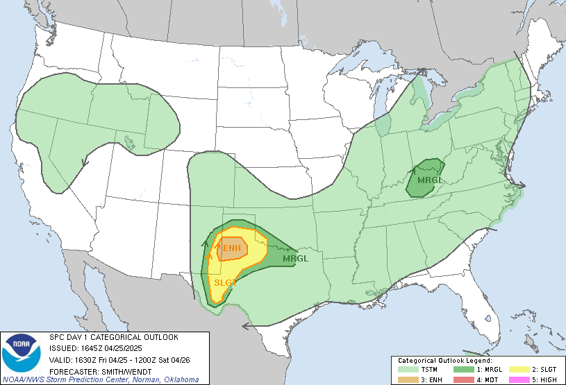
For today in Texas, a potential severe weather/tornado outbreak after 4 pm from Waco, DFW, to Longview:

For today in Texas, a potential severe weather/tornado outbreak after 4 pm from Waco, DFW, to Longview:

East and north of me, but...
https://www.spc.noaa.gov/products/md/md0436.html
Mesoscale Discussion 0436
NWS Storm Prediction Center Norman OK
1218 PM CDT Sun Apr 02 2023
Areas affected...southeast Texas toward into far western Louisiana
Concerning...Severe potential...Watch possible
Valid 021718Z - 022015Z
Probability of Watch Issuance...40 percent
SUMMARY...Scattered storms may develop over the next few hours, and
large hail will be possible with the stronger cells. A watch could
be considered later today, depending on convective evolution.
DISCUSSION...A warm front currently stretches from near Austin
toward Houston, with 70s F dewpoints to the south. Visible imagery
shows filtered heating across much of the moist sector, with
substantial deepening CU fields noted. North of the warm front
across eastern TX into LA, clear skies will lead to steepening
low-level lapse as moisture continues to surge northward into this
air mass.
Observed and model soundings indicate a warm layer close to 700 mb,
but these temperatures cool with eastward extent and into LA. For
example, currently 3-4 C difference between Austin and the TX/LA
border.
As such, the most likely area for storm development will be within
the low-level theta-e advection regime, and beneath the cooler
temperatures aloft. CAMs suggest at least isolated activity will
occur this afternoon, and ample instability, long hodographs and
sufficiently steep midlevel lapse rates will favor hail production.
Given subtle lift, it may take some time for cells to become severe.
..Jewell.. 04/02/2023
...Please see www.spc.noaa.gov for graphic product...
ATTN...WFO...LCH...SHV...HGX...FWD...
Day 1 Convective Outlook
NWS Storm Prediction Center Norman OK
1115 AM CDT Sun Apr 02 2023
Valid 021630Z - 031200Z
...THERE IS AN ENHANCED RISK OF SEVERE THUNDERSTORMS OVER MUCH OF
NORTH TEXAS THIS AFTERNOON AND EVENING...
...SUMMARY...
Scattered severe thunderstorms are expected across central to
northeast Texas between 2 to 11 PM CDT. Very large hail and several
tornadoes are possible, a couple of which may be strong.
...TX/OK/LA...
Morning water vapor loop shows a well-defined and compact midlevel
shortwave trough moving quickly eastward across NM/Southwest TX.
This trough and its associated 60-70kt midlevel jet will track
across TX this afternoon and evening, providing large scale ascent
for a round of intense thunderstorms. Low-level moisture is
returning northward quickly this morning, with dewpoints in the 60s
expected as far north as the Red River. A combination of relatively
strong surface heating, very steep midlevel lapse rates, and rapid
cooling of midlevel temperatures will yield a corridor of afternoon
MLCAPE values ~2000 J/kg along and east of the dryline.
Current indications are that thunderstorms will form quickly by
mid-afternoon along and east of the dryline over western North Texas
and southwest OK as the upper trough arrives. These storms will
likely intensify rapidly into supercells with a risk of very large
hail and a tornado or two. This activity will increase in coverage
as it spreads eastward along the northern edge of rapid moisture
return toward the DFW metro area. Very large hail will remain a
concern, but most model guidance also shows strengthening low-level
wind fields and shear, promoting an increasing risk of tornadoes and
damaging wind gusts. A strong tornado or two will be possible.
By mid-evening, activity will likely congeal into an MCS tracking
eastward into northeast TX and northwest LA. Damaging wind risk
will increase, while the risk of hail and a tornado or two persists.
There is uncertainty how far east this MCS will maintain a severe
risk. Will not adjust the outlook areas at this time, but will
re-evaluate the need for SLGT farther east in later updates.
..Hart/Lyons.. 04/02/2023
In the next week, I think the main rain event could be east of CLL. Houston could benefit from the stalled front. We *might* get enough rain so I don't have to water.
There could be another tornado outbreak in Arkansas, Iowa, Illinois:

There could be another tornado outbreak in Arkansas, Iowa, Illinois:

Chance of rain just dropped from 50% to 30% here in CLL for today. No surprise.
College Station could get several inches of rain this week. Houston as well.
-
Stratton20
- Posts: 4248
- Joined: Tue Feb 09, 2021 11:35 pm
- Location: College Station, Texas
- Contact:
-
TexasBreeze
- Posts: 942
- Joined: Sun Sep 26, 2010 4:46 pm
- Location: NW Houston, TX
- Contact:
Glad that phpBB server issue is resolved on here and S2k! There was no plan C for seeing posts since both sites were out.
How do you know what happened?TexasBreeze wrote: ↑Sun Apr 02, 2023 1:36 pm Glad that phpBB server issue is resolved on here and S2k! There was no plan C for seeing posts since both sites were out.
The 12Z Euro. The Euro has been pretty consistent with the front stalling around the I-59 corridor.
- srainhoutx
- Site Admin

- Posts: 19616
- Joined: Tue Feb 02, 2010 2:32 pm
- Location: Maggie Valley, NC
- Contact:
It happened. Glad both sites are back up and running smoothly!Cpv17 wrote: ↑Sun Apr 02, 2023 1:54 pmHow do you know what happened?TexasBreeze wrote: ↑Sun Apr 02, 2023 1:36 pm Glad that phpBB server issue is resolved on here and S2k! There was no plan C for seeing posts since both sites were out.
Carla/Alicia/Jerry(In The Eye)/Michelle/Charley/Ivan/Dennis/Katrina/Rita/Wilma/Humberto/Ike/Harvey
Member: National Weather Association
Facebook.com/Weather Infinity
Twitter @WeatherInfinity
Member: National Weather Association
Facebook.com/Weather Infinity
Twitter @WeatherInfinity
-
Stratton20
- Posts: 4248
- Joined: Tue Feb 09, 2021 11:35 pm
- Location: College Station, Texas
- Contact:
Interesting to see global models consistently spitting out pretty high rain fall totals for the region, will be very interesting to see the mesoscale model outputs once they get into range, stalled fronts almost always spell flooding issues around here even with dry grounds
Count me as highly skeptical. If the front stalls over CLL, then maybe.Stratton20 wrote: ↑Sun Apr 02, 2023 1:35 pm DoctorMu euro and GFS both give CS a ton of rain , pretty good agreement
This has been one of those springs where the energy has been ripping east and north of here. Houston will see significant rain on the stalled front.
NOAA dropped rain chances later in the week for CLL to 50%, peaking at 70% Thursday night. 80-90% in Houston for days.
