

May 2023
Very sharp gradient along I45

Feast or famine. Par for the course.

Yep. Folks, without a cap, and with s/w pulses and warming there's going to be unsettled weather all week. Who gets how much, when, and where is simply damn near impossible to predict given the complexity and chaotic nature of pinpointing movement of discrete MSC, s/w's, etc.
I'm just enjoying green grass, trees, and foliage, a sprinkler system that is shut off, and protection of the clouds from running our A/C nearly non stop. Give me this for the entire summer and into football season!

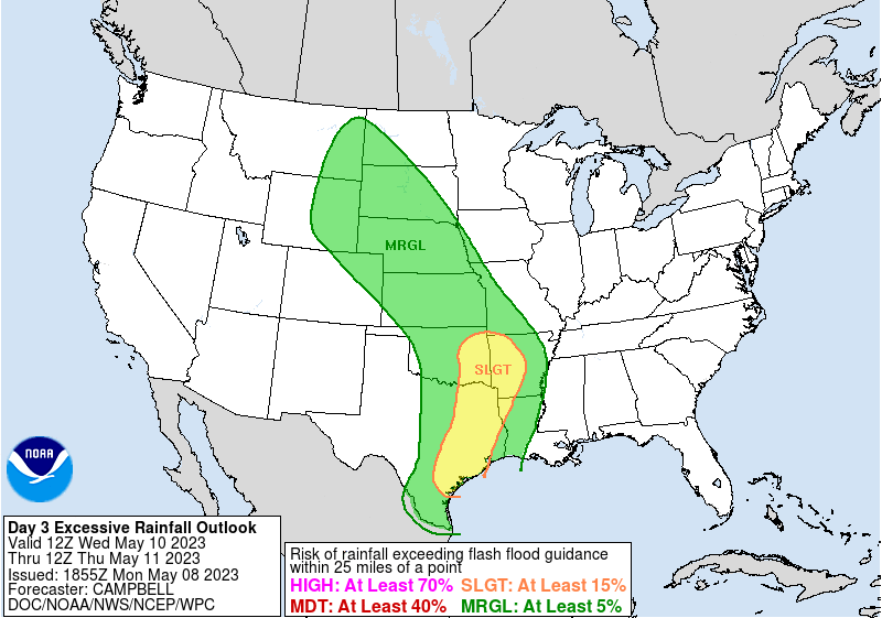
Looks like the WPC just increased the rainfall totals...
In the most immediate forecast, tomorrow's s/w could be a rainmaker. We'll see exactly where tomorrow during now-casting time.
Area Forecast Discussion
National Weather Service Houston/Galveston TX
1232 PM CDT Mon May 8 2023
...New AVIATION...
.SHORT TERM...
(Today through Tuesday Night)
Issued at 215 AM CDT Mon May 8 2023
Gonna be a wet, possibly very wet, start to the work week - and
after yesterday`s rainfall overperformance, I sided with the wetter
solutions for both today and tomorrow. The parade of short waves
continues through the short term bringing additional showers and
thunderstorms to the region. The disturbance today will be the
weaker of the two, but with PWATs nearing 1.8" the storms that do
develop may produce some isolated heavy rainfall. Timeframe for
today`s rainfall will be in the morning through late afternoon with
a general winding down in coverage through the evening. The reprieve
overnight will not last long as the next shortwave moves through the
region tomorrow morning. Expect an increase in shower and
thunderstorm activity by sunrise coming from the southwest and
expanding across much of the region by the mid to late morning and
persisting through the afternoon. There may be a reduction in
coverage by the late afternoon, but showers and thunderstorms will
be possible through the night. There is a Slight Risk for Excessive
Rainfall on Tuesday leading to minor urban and small stream
flooding. This is due to not only the potential for up to 2 to 4" of
rain with locally higher amounts (mainly along the coast), but also
due to already wet soils from yesterday`s and today`s rainfall. If
today ends up on the drier side, the potential for excessive
rainfall for Tuesday will be lower, but on the flipside if today
ends up being wetter than expected than the flooding potential
increases on Tuesday. Not looking much like a severe weather threat
for either today or Tuesday, but soundings do show long-skinny CAPE
profiles indicating that the storms will be proficient rain-makers.
Expect high temperatures this afternoon to rise into the upper 80s
(maybe a few spots of 90 degrees where the sun peaks out), but high
temperatures on Tuesday will only get into the low to mid 80s due
to the increased precipitation coverage. Overnight lows tonight and
Tuesday night will be in the low to mid 70s.
Fowler
&&
.LONG TERM...
(Wednesday through Sunday)
Issued at 215 AM CDT Mon May 8 2023
Tuesday`s shortwave will drift north of our area by Wednesday. In
its wake will be another series of shortwaves, though not as
aggressive as Tuesday`s shortwave. Continued deep onshore flow
will keep PWATs high through week`s end. Therefore, we continue to
think that there will be a daily risk of scattered showers and
thunderstorms through the end of the week. The primary concern
from the thunderstorms will be locally heavy rainfall. There is
some indication that another more aggressive shortwave could
impact the region by the weekend. However, confidence is low that
far out into the forecast period. We continued to bias our daily
long term PoPs higher than the NBM guidance due to the high PWs
and expected shortwave induced PVA. Afternoon temperatures through
the long term are expected to be in the low/mid-80s with
overnight lows in the low/mid-70s. Couldn`t rule out slightly
hotter temperatures on some days if rainfall activity and cloud
cover prove to be less widespread like the NBM suggests.
Self
&&
.AVIATION...
(18Z TAF Issuance)
Issued at 1221 PM CDT Mon May 8 2023
A mix of MVFR to VFR ceilings remain across SE TX and may persist
for much of the day today. Areas of Iso-Sct SH/TS are expected
today, however, it will be hard to pin when and where. Thus, will
handle much of today`s wx with TEMPOs if needed. S-SE winds at
10-15 KTS today with a few gusts today but may be stronger in and
around SH/TS. Winds will be 6-12 KTS tonight into Tue. Lower
ceilings are expected once again tonight into Tue morning, and a
few sites may reach IFR for a few hours. A mid to upper level
trough/low will be moving into SE TX Tue and is expected to bring
higher chances of SHRA and TSRA throughout the day.
24
&&
.MARINE...
Issued at 215 AM CDT Mon May 8 2023
The onshore flow regime is expected to continue through the
forecast period. Generally moderate southeasterly winds are
expected through the weekend. Winds may occasionally be stronger,
especially at night through the early morning hours. This may
warrant caution flags and even potential advisories. Seas are
expected to be in the 3-6 foot range. Occasionally higher seas
cannot be ruled out. There will also be a daily risk of showers
and thunderstorms through the end of the week. Locally higher
winds and seas will be possible in an near any thunderstorm.
&&
.PRELIMINARY POINT TEMPS/POPS...
College Station (CLL) 88 71 83 68 / 50 20 70 40
Houston (IAH) 87 72 83 70 / 50 20 70 40
Galveston (GLS) 82 75 81 74 / 40 20 50 30
Storms developing to the northeast, should congeal into a complex and move south this afternoon from its cold pool.

I am only going to show QPF's in the higher confidence period of now - 12th of May. the forecast is low confidence after that. Note that each solution has a different epicenter of rain. All about 2-3 inches. Local amounts will vary. Welcome to the Heisenberg Uncertainty Principle of Weather! 
- Attachments
-
-
-
How is that suppose to work? Looks like that complex is rocketing off due east right now.
Edit: Nevermind. No sooner than I typed that, I see cells popping up near Wharton.
Last edited by Cromagnum on Mon May 08, 2023 2:02 pm, edited 1 time in total.
-
TexasBreeze
- Posts: 942
- Joined: Sun Sep 26, 2010 4:46 pm
- Location: NW Houston, TX
- Contact:
Yeah I see them currently going away, unless they backbuild further to the west southwest. There are little cells forming currently.
-
redneckweather
- Posts: 1023
- Joined: Mon Feb 08, 2010 7:29 pm
- Location: Montgomery, Texas
- Contact:
Strong storms now starting to pop up quickly to the SW.

Man the QPF just about has the entire state of Texas covered.
Mike
Beaumont, TX
(IH-10 & College Street)
Beaumont, TX
(IH-10 & College Street)
-
tireman4

- Global Moderator

- Posts: 4480
- Joined: Wed Feb 03, 2010 9:24 pm
- Location: Humble, Texas
- Contact:
.AVIATION...
(18Z TAF Issuance)
Issued at 1221 PM CDT Mon May 8 2023
A mix of MVFR to VFR ceilings remain across SE TX and may persist
for much of the day today. Areas of Iso-Sct SH/TS are expected
today, however, it will be hard to pin when and where. Thus, will
handle much of today`s wx with TEMPOs if needed. S-SE winds at
10-15 KTS today with a few gusts today but may be stronger in and
around SH/TS. Winds will be 6-12 KTS tonight into Tue. Lower
ceilings are expected once again tonight into Tue morning, and a
few sites may reach IFR for a few hours. A mid to upper level
trough/low will be moving into SE TX Tue and is expected to bring
higher chances of SHRA and TSRA throughout the day.
24
Wouldn’t be surprised to see some flooding going on around Kountze. They’ve been getting pounded for a good hour or so.
-
Iceresistance
- Posts: 577
- Joined: Fri Apr 30, 2021 11:48 pm
- Location: Tecumseh, OK
- Contact:
Why is there a tornado trying to develop near Beaumont?
Why did the storms that moved across Fort Bend into Harris just vaporize when everywhere else they are building? Ugh
For Wednesday:
I'm not really surprised. Just got back an hour ago from driving to (and back from) San Marcos. The area between Schulenburg and a bit west of Katy was quite unsettled, but was much more settled once I got to just west of Katy.
Horrible in Beaumont. Flooding on MLK.
Mike
Beaumont, TX
(IH-10 & College Street)
Beaumont, TX
(IH-10 & College Street)