Yesterdays storms were crazy. I had to drive through Sweeny yesterday and that was some of the heaviest rains I’ve ever driven through. I love heavy rain like that but not when I have to drive through it. I think this weekend is the next chance for rain around 30% both days.
May 2023
Right on queue, the mosquito plague has erupted.
-
Stratton20
- Posts: 4246
- Joined: Tue Feb 09, 2021 11:35 pm
- Location: College Station, Texas
- Contact:
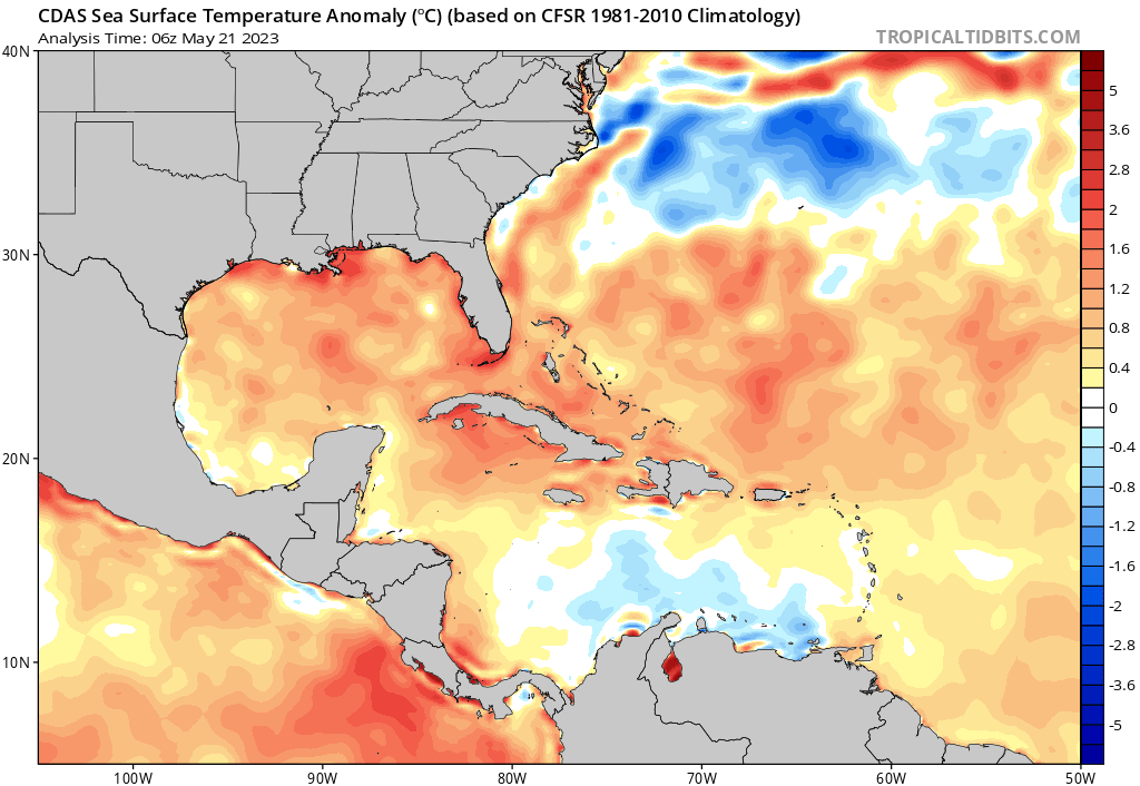
Even though models arent showing anything right now, we may have to watch this weekends front as it its forecast to clear the area and stall in the gulf of mexico, we are getting to that time of the year in which every front that gets out into the open waters of the GOM needs to be watched, waters are definitely warm enough for a quick spin up, just my opinion, just another reminder hurricane season is almost here, and its home grown season time
-
tireman4

- Global Moderator

- Posts: 4471
- Joined: Wed Feb 03, 2010 9:24 pm
- Location: Humble, Texas
- Contact:
000
FXUS64 KHGX 181119
AFDHGX
Area Forecast Discussion
National Weather Service Houston/Galveston TX
619 AM CDT Thu May 18 2023
...New AVIATION...
.SHORT TERM...
(Today through Friday Night)
Issued at 249 AM CDT Thu May 18 2023
Warm and humid but otherwise generally uneventful conditions will
persist throughout the remainder of the week prior to the approach
of a weak cold front this weekend. Synoptically, the pattern will
remain generally benign as SE TX continues to remain under a broad
surface high. As this system pushes off to the east during the day
today, we will reestablish a south wind that should remain near or
below 10 mph during the afternoon. Clear skies, along with gradual
midlevel ridging and a resumption of WAA/onshore moisture transport,
will allow for highs to rise into the upper 80s across the majority
of the area. Overnight lows should by a degree or two (upper 60s to
low 70s) given the aforementioned weak WAA.
The initial portion of the day on Friday will look similar to that
of today, with high temperatures reaching the 90s in some locations
(thanks in part to SW winds aloft along with increasing surface wind
speed and thus increased WAA). A weak surface cold front is expected
to approach the area late in the day, potentially bringing some
isolated showers and storms to the far northern zones (the bulk of
the frontal passage should occur on Saturday). Otherwise, another
evening with lows in the lower 70s expected.
Cady
&&
.LONG TERM...
(Saturday through Wednesday)
Issued at 249 AM CDT Thu May 18 2023
A weak frontal boundary will make its way into the area Saturday.
Overall forcing/dynamics are nothing to write home about, but wouldn`t
be too surprised to see some isolated to scattered late afternoon
& evening storms develop across cntl/southern parts of the area
with daytime temps climbing to near 90 and PW`s sitting in the
1-8-2.0" range. Also looks like a fairly good setup for high temps
along the beaches to flirt with records considering light nw-w winds.
Front should sag off the coast Saturday night, though clouds and
maybe even a few isolated shra remain a possibility on Sunday as
upper level disturbances ride over the northern periphery of the
ridge across the western Gulf.
Early part of next week looks mainly dry with some weak mid level
ridging to our west and lower level ridging stretching from the
Eastern Seaboard into La/east Tx. UKMET & GFS are hinting at a possible
shortwave embedded in the nw flow aloft that may be worth keeping
an eye on Mon or Tue, but moisture availability appears to be on
the low side. Guidance does generally seem to be on the same page
bringing a plume of higher PW`s around the western periphery of
the llvl ridging to our east and into the region on Wed. Re-introduced
some low end POPs to the fcst during that time period. 47
&&
.AVIATION...
(12Z TAF Issuance)
Issued at 618 AM CDT Thu May 18 2023
A few areas of fog continue to linger this morning, thus far only
impacting LBX. Fog should dissipate after sunrise, after which VFR
conditions and light winds will prevail for the duration of the
TAF period. Winds will shift to the SE/S today, but should remain
below 10 knots throughout the period.
Cady
&&
.MARINE...
Issued at 249 AM CDT Thu May 18 2023
Light winds and low seas will continue through the weekend into
next week. Might need to keep an eye out for some isolated-
scattered storms late Saturday afternoon and evening as a weak
front approaches the coast. 47
&&
.PRELIMINARY POINT TEMPS/POPS...
College Station (CLL) 87 68 89 69 / 0 0 0 20
Houston (IAH) 88 70 90 71 / 0 0 0 0
Galveston (GLS) 83 75 86 74 / 0 0 0 0
&&
.HGX WATCHES/WARNINGS/ADVISORIES...
TX...None.
GM...None.
&&
$$
SHORT TERM...Cady
LONG TERM....47
AVIATION...Cady
MARINE...47

This is some unhappy news. The oldest home in Dickinson, a historical home, was struck by lightning and lost due to a fire.
https://www.chron.com/news/houston-texa ... 105150.php
https://www.chron.com/news/houston-texa ... 105150.php

Rainfall over the last 2 weeks.A big chunk of the area has received 6+ inches of rain.With some localized spots of 8-10 inches. ( Overall SE Texas and the coastal bend ended up with the highest rainfall totals in the state.)
 ( Overall SE Texas and the coastal bend ended up with the highest rainfall totals in the state.)
Last edited by don on Thu May 18, 2023 5:11 pm, edited 1 time in total.
It’s a lil hot out there but this weather is actually pretty nice. It could be much worse for the middle of May. I got very spoiled by getting 6+” over a 10 day span. Back to our regularly scheduled programming with not one single bit of excitement in the foreseeable future.
-
tireman4
- Global Moderator
- Posts: 4471
- Joined: Wed Feb 03, 2010 9:24 pm
- Location: Humble, Texas
- Contact:
FXUS64 KHGX 191137
AFDHGX
Area Forecast Discussion
National Weather Service Houston/Galveston TX
637 AM CDT Fri May 19 2023
...New AVIATION...
.SHORT TERM...
(Today through Saturday Night)
Issued at 309 AM CDT Fri May 19 2023
A steadier onshore wind is expected to develop today as broad
surface high pressure continues to drift into the Central Gulf of
Mexico. While the synoptic pressure gradient will continue to remain
comparatively weak, the resultant enhancement of low-level moisture
transport will result in a marginal increase in surface dew points.
Resultant WAA in addition to efficient daytime mixing will provide a
slightly warmer day today than yesterday, with many locations
expected to eclipse the 90-degree mark.
Meanwhile, to our north, a weak surface cold frontal boundary will
slowly push through the Central Plains and eventually approach the
area this evening, with scattered showers and storms forming along
and ahead of the boundary. However, latest guidance continues to
indicate relatively weak SB instability at the time of the front`s
arrival in our northern zones tonight, which combined with fairly
dry conditions aloft should limit the potential for any stronger
storms. Overnight lows will once again remain near 70 for most
locations, and in the mid 70s along the immediate coast.
Tomorrow, rain chances return to the forecast as the aforementioned
surface front pushes southward through the area, with scattered
showers/storms developing during the afternoon and evening hours as
SB instability has some marginal increases with diurnal heating and
with the potential inland advance of a sea breeze boundary. However,
neither strong storms nor heavy rain are expected with this
development. Highs will be somewhat dependent on the exact timing of
the front and subsequent shift to north winds in its wake, along
with the exact timing and extent of rainfall coverage. In general,
most locations north of the Houston metro should see highs limited
to the mid 80s with the aforementioned frontal passage while other
locations will once again see highs in the upper 80s/lower 90s.
Cady
&&
.LONG TERM...
(Sunday through Thursday)
Issued at 309 AM CDT Fri May 19 2023
Cloudiness should persist Sunday in the wake of the diffuse
frontal passage. Disturbances in the mid/upper level flow may be
able to generate some iso shra, but models seem to be trending
even drier than some of the earlier runs. Overall, expecting a
fairly pleasant day in regards to temps with readings only
topping out in the 78-83 degree range.
Remainder of the work week looks pretty uneventful with mid-upper
ridging building back northward across Mexico into Tx...placing us
in a nw flow aloft. Temps will return back to near seasonal norms.
Rain chances, though not exactly nil, should be low and mainly
diurnally driven. 47
&&
.AVIATION...
(12Z TAF Issuance)
Issued at 632 AM CDT Fri May 19 2023
A few spotty areas of fog will persist over the next 1-2 hours,
dissipating with daytime heating. VFR conditions should prevail
through the day with light south winds and scattered cloud cover.
Tonight, a cold front will approach the area, potentially
resulting in the development of showers and storms (most of this
development should occur outside of the TAF period). As the front
pushes through the area, reaching CLL around 09Z and IAH around
sunrise, there will be a shift to north/northwest winds (though
wind speeds should remain below 10 knots). Heading into tomorrow,
additional showers and storms will be possible as the front
continues to make its way through the area.
Cady
&&
.MARINE...
Issued at 309 AM CDT Fri May 19 2023
A light wind regime and low seas will persist well into next week.
Landbreeze/seabreeze circulations should be observed for a good
portion of the period. 47
&&
.PRELIMINARY POINT TEMPS/POPS...
College Station (CLL) 90 70 83 67 / 0 20 20 10
Houston (IAH) 91 71 88 70 / 0 10 20 10
Galveston (GLS) 85 74 85 74 / 0 10 20 10
&&
.HGX WATCHES/WARNINGS/ADVISORIES...
TX...None.
GM...None.
&&
$$
SHORT TERM...Batiste
LONG TERM....Batiste
AVIATION...Cady
MARINE...Batiste

Mild FROPA Saturday. Only a 20% chance of rain, but cloudy, "cooler." A pleasant week for late May, then boring after that until a potential back door FROPA in early June.
-
tireman4
- Global Moderator
- Posts: 4471
- Joined: Wed Feb 03, 2010 9:24 pm
- Location: Humble, Texas
- Contact:
000
FXUS64 KHGX 192010
AFDHGX
Area Forecast Discussion
National Weather Service Houston/Galveston TX
310 PM CDT Fri May 19 2023
...New SHORT TERM, LONG TERM, MARINE...
.SHORT TERM...
(This evening through Saturday Night)
Issued at 305 PM CDT Fri May 19 2023
Ridging of high pressure aloft and sfc high centered to our east
will continue to provide warm and drier weather across the region. A
weak cold front, currently extending along the Dallas/Fort Worth
area, will enter our region overnight tonight. No significant
impacts are expected with this FROPA, other than a wind shift to
the north-northwest along with a few showers or storms. Elevated
instability tonight and Saturday morning is meager, and just a bit
better across our far western counties, including the Brazos
Valley area. Therefore, have continued with a slight chance of
showers and storms for this area through early Sat morning. The
front is progged to reach SETX early Saturday, reaching the
coastal waters by mid-late morning. Drier air in the mid to upper
levels will keep most of the area dry behind the front. The
exception will be along the coastal areas where a little surface
instability may allow isolated showers or storms to develop in the
afternoon. Warm and humid weather will persist, even behind the
frontal passage. Highs will generally be in the 80s, with a few
spots reaching the low 90s. Overnight lows in the 60s and 70s.
JM|
&&
.LONG TERM...
(Sunday through next Thursday)
Issued at 305 PM CDT Fri May 19 2023
Another round of showers and thunderstorms is possible during the
day on Sunday as ridging aloft weakens in response to mid to upper
level disturbances moving across the region. PWs on Sunday will
range between 1.5 to 1.8 inches, with the highest values lying
across the southern half of Southeast TX. Although latest model
solution is trending with less rain activity for Sunday, have kept
low PoPs (20% or less) in the forecast given that the available
moisture and pattern aloft may be sufficient to produce isolated to
possible scattered showers and thunderstorms, in particular during
the afternoon hours. Otherwise, expect mostly cloudy skies and
cooler conditions (highs in the upper 70s to low 80s). The cooler
conditions will be short-lived as a warming trend begins on Monday
and we will once again have highs in the upper 80s to low 90s for
much of the work week. Periods of isolated to scattered showers and
thunderstorms are in the forecast from Tuesday to Thursday as upper
level shortwaves move across the region.
24
&&
.AVIATION...
(18Z TAF Issuance)
Issued at 1225 PM CDT Fri May 19 2023
VFR conditions will prevail this afternoon and evening with light
southerly winds. A weak cool front is expected to enter Southeast
TX late tonight/early Saturday morning. No major impacts are
expected with this FROPA other than a wind shift to the northwest-
north with gusts up to 20 knots possible. SCT to BKN MVFR ceilings
can be expected during the morning hours, particularly for
terminals north of IAH. A few showers/storms will be possible as
the front moves through; however, confidence in occurrence and
timing is very low to include in TAFs.
JM
&&
.MARINE...
Issued at 305 PM CDT Fri May 19 2023
Light winds and seas of 1 to 2 feet, along with a diurnal wind
pattern can be expected through much of the forecast period. There
is a chance for isolated showers and thunderstorms this weekend as a
weak cold front moves into the coastal waters. Another round of
showers and isolated storms can be expected mid week next week.
24
&&
.PRELIMINARY POINT TEMPS/POPS...
College Station (CLL) 69 82 65 79 / 20 10 10 20
Houston (IAH) 71 88 68 81 / 0 20 10 20
Galveston (GLS) 74 86 74 84 / 0 20 10 20
&&
.HGX WATCHES/WARNINGS/ADVISORIES...
TX...None.
GM...None.
&&
$$
SHORT TERM...JM
LONG TERM....24
AVIATION...JM
MARINE...24
We'll see if that cell around Temple makes it to CLL.
Probably just an outflow. We'll see.
Probably just an outflow. We'll see.

It’s been a really nice day down in Wharton County so far. Temps in the low 80’s and a lot of clouds around. Not too bad.
Rain may be back on the menu around the end of the month,as several models show a northwest flow aloft starting up.We'll see how the models trend over the next week.
-
MontgomeryCoWx

- Posts: 2356
- Joined: Wed Dec 14, 2011 4:31 pm
- Location: Weimar, TX
- Contact:
Coached 2 Baseball games today and mowed the yard.
I’m ready for Fall.
I’m ready for Fall.
Team #NeverSummer
-
Stratton20
- Posts: 4246
- Joined: Tue Feb 09, 2021 11:35 pm
- Location: College Station, Texas
- Contact:
Summer has just started and im already ready for the first fall front haha, let us move through the next 5 months of hell like weather quickly
Today was upper 70s here in the NW territories. Partly cloudy. Northerly breeze. Very nice.
More of the same tomorrow.
*Just* 104 days until the first TAMU football game.
I have a minute but real confidence that El Niño can serve up more clouds and occasional rain this summer in SETX.
We have Cicadas coming out of the ground and buzzing in the afternoon. I don't remember them coming out in May. Sounds of summer. Football can't be far away.
The Gulf is cooking: