
May 2023
Looks like 1 more day of this glorious low dew point weather and then sweaty sauna hell season kicks off. At least it's been cut down to 5 and a half months instead of the normal 6.
-
Stratton20
- Posts: 4246
- Joined: Tue Feb 09, 2021 11:35 pm
- Location: College Station, Texas
- Contact:
Dont like the model trends today with keeping most of the rain focused in central north and west texas
Not concerned. Euro and EPS look great. CPC has a bullseye over southeast Texas as well.Stratton20 wrote: ↑Tue May 02, 2023 7:22 pm Dont like the model trends today with keeping most of the rain focused in central north and west texas


They can actually use the rain more.Stratton20 wrote: ↑Tue May 02, 2023 7:22 pm Dont like the model trends today with keeping most of the rain focused in central north and west texas
https://droughtmonitor.unl.edu/CurrentM ... aspx?South
-
Stratton20
- Posts: 4246
- Joined: Tue Feb 09, 2021 11:35 pm
- Location: College Station, Texas
- Contact:
00z CMC is looking better for SE Texas
The 0z Euro and EPS look outstanding if you want rain here in southeast TX. They match up perfectly to what the CPC is showing.
Looks like a round late Thursday for parts of our area then a 2nd round late Friday.
-
tireman4

- Global Moderator

- Posts: 4471
- Joined: Wed Feb 03, 2010 9:24 pm
- Location: Humble, Texas
- Contact:
00
FXUS64 KHGX 031121
AFDHGX
Area Forecast Discussion
National Weather Service Houston/Galveston TX
621 AM CDT Wed May 3 2023
...New AVIATION...
.SHORT TERM...
(Today through Thursday Night)
Issued at 235 AM CDT Wed May 3 2023
Increasing southeasterly flow at the surface and ridging aloft
will lead to warmer conditions across SE Texas today and Thursday
with highs climbing into the mid to upper 80s. Overnight low
temperatures will dip into the low 60s north of Harris County,
mid 60s along the I-10 corridor, and to near 70 along the coast.
Overnight low become unseasonably warm Thursday night due to the
southeasterly flow and overcast skies causing low temperatures to
only dip into the low to mid 70s for most of the region.
Can expected some patchy fog forming in low lying areas this
morning when winds become calm. This fog won`t last long and will
dissipate shortly after sunrise - though may make a return tonight
into Thursday morning. There may be very isolated streamer
showers this afternoon, but the chance of precipitation increases
Thursday. The upper level ridge begins to weaken as a few
shortwaves traverse across Texas. These disturbances will bring a
chance of showers and thunderstorms will tap into the 1.5" to
near 2" PWATS Thursday afternoon into Thursday night. While the
majority of the storms that develop Thursday will be general
thunderstorms, there is a Marginal Risk of strong to severe
thunderstorms for the northwestern parts of the region.
Fowler
&&
.LONG TERM...
(Friday through Tuesday)
Issued at 235 AM CDT Wed May 3 2023
Synoptic pattern looks relatively unchanged for Friday as ridging
continues across the Plains/Mississippi River Valley. Shortwave
energy is expected to round the bottom of this upper level ridge,
tapping into 1.7-1.9" PWs to bring isolated showers and
thunderstorms during the day. NAEFS mean 850mb temperatures are
progged to exceed the 90th percentile with deterministic models
showing 850mb temperatures reaching 17-19C during the afternoon.
This comes with southwesterly flow in the lower levels and a 590 dam
midlevel ridge over the Gulf of Mexico. These factors point towards
unseasonably warm temperatures in spite of the cloudy skies with
highs progged in the upper 80s to lower 90s. Dewpoints are expected
to reach the mid to lower 70s during this time frame, which should
bring peak heat indicies near triple digits. While these conditions
do not meet the standard criteria for a head advisory, early season
heat events can be especially stressful on the body. Those planning
to spend time outdoors should practice heat safety on Friday through
portions of the weekend. Be sure to drink plenty of water and limit
outdoor activity when possible. Overnight lows will also be
unpleasantly warm, generally in the mid to lower 70s across SE Texas.
The aforementioned upper level ridge should amplify and drift
eastward through the Mississippi River Valley on Saturday. 850mb
temperatures are progged to rise by a degree or so, which should
bring a slight increase to highs and more widespread triple digit
heat indicies. Periods of showers/storms remain possible through the
weekend and into next week as more shortwave energy rounds the
bottom of the upper level ridge. The continued eastward progression
of the upper level ridge should reduce its influence over the
region, providing a mild reprieve from the unseasonable heat on
Sunday through Tuesday.
03
&&
.AVIATION...
(12Z TAF Issuance)
Issued at 550 AM CDT Wed May 3 2023
Some patchy ground fog has developed in the southwestern portion
of the region this morning impacting LBX and SGR at times, but
this fog will be dissipating by 13-14z this morning. Then VFR
conditions will prevail through the day with easterly flow between
7 and 10kts. Light east to southeasterly winds expected tonight
with increasing cloud cover by daybreak Thursday.
Fowler
&&
.MARINE...
Issued at 235 AM CDT Wed May 3 2023
Light to moderate, east to southeast winds with seas 4 feet or less
are expected through early next week. Caution flags could be needed
at times. Low rain chances are expected through the weekend,
increasing into early next week.
03
&&
.PRELIMINARY POINT TEMPS/POPS...
College Station (CLL) 85 62 85 71 / 0 0 30 30
Houston (IAH) 86 64 85 72 / 0 0 20 20
Galveston (GLS) 79 71 82 74 / 0 0 10 10
&&
.HGX WATCHES/WARNINGS/ADVISORIES...
TX...None.
GM...None.
&&
$$
SHORT TERM...Fowler
LONG TERM....03
AVIATION...Fowler
MARINE...03

The DP is soaring a day early.
Welcome to the Jungle!
Welcome to the Jungle!
Heat indices of 102 and 103 expected on Friday / Saturday.
Disgusting.
Disgusting.
-
Stratton20
- Posts: 4246
- Joined: Tue Feb 09, 2021 11:35 pm
- Location: College Station, Texas
- Contact:
Cromagnum couldn’t agree more, awful lol
-
Iceresistance
- Posts: 577
- Joined: Fri Apr 30, 2021 11:48 pm
- Location: Tecumseh, OK
- Contact:
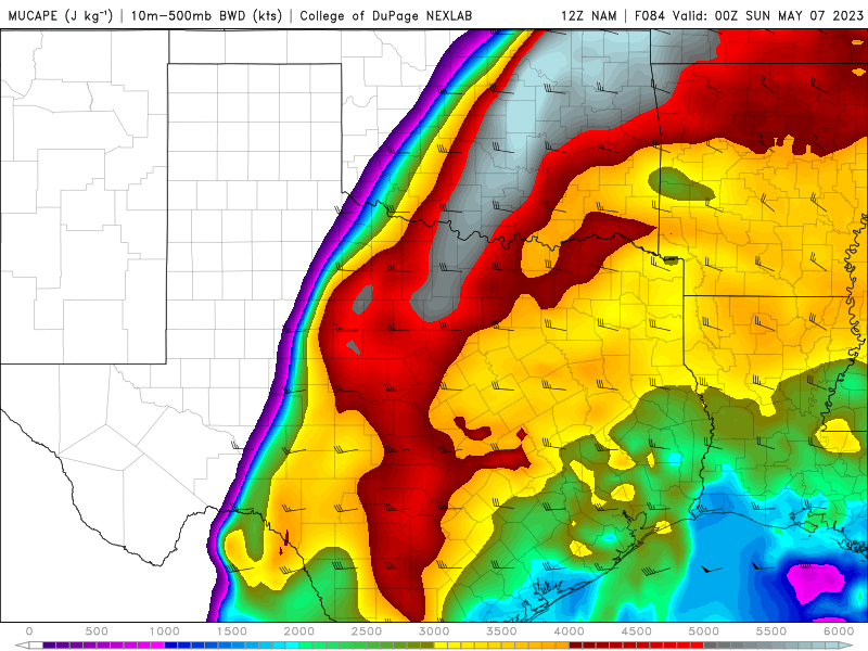
Holy bejeebers, this is from the 12z NAM MUCAPE, it's over 6000!
https://s12.gifyu.com/images/12z-NAM.png
https://s12.gifyu.com/images/12z-NAM.png
-
Stratton20
- Posts: 4246
- Joined: Tue Feb 09, 2021 11:35 pm
- Location: College Station, Texas
- Contact:
18z GFS has a pretty slow moving upper low just meandering around our area for several days, nothing heavy but something to watch as slow moving lows always spell trouble
I will say one thing, rain chances do look better north of I-10 over the next week or so.
This could get interesting. May has had many weather events in the past.
-
Stratton20
- Posts: 4246
- Joined: Tue Feb 09, 2021 11:35 pm
- Location: College Station, Texas
- Contact:
00z GFS and CMC both coming in way wetter for SE texas fwiw, GFS with over a foot of rain in some spots
- Attachments
-
-
The 6z GFS has lost its mind.

If you went by the iPhone Weather App you’d think it was monsoon season. 70-80% chances of rain almost every day. Shows 70% today.
NWS keeps advertising 20-30% chances.
The reality has been more like Tucson lately.
What do I think? Imma about to turn the sprinklers on.
NWS keeps advertising 20-30% chances.
The reality has been more like Tucson lately.
What do I think? Imma about to turn the sprinklers on.