April 2023

General Weather Discussions and Analysis
User avatar
DoctorMu
Posts: 5669
Joined: Sun Jun 28, 2015 11:58 am
Location: College Station
Contact:

In the next week, I think the main rain event could be east of CLL. Houston could benefit from the stalled front. We *might* get enough rain so I don't have to water.

There could be another tornado outbreak in Arkansas, Iowa, Illinois:

Image
User avatar
DoctorMu
Posts: 5669
Joined: Sun Jun 28, 2015 11:58 am
Location: College Station
Contact:

Chance of rain just dropped from 50% to 30% here in CLL for today. No surprise.
Cpv17
Posts: 5285
Joined: Fri Aug 31, 2018 1:58 pm
Location: El Campo/Wharton
Contact:

DoctorMu wrote: Sun Apr 02, 2023 1:25 pm In the next week, I think the main rain event could be east of CLL. Houston could benefit from the stalled front. We *might* get enough rain so I don't have to water.

There could be another tornado outbreak in Arkansas, Iowa, Illinois:

Image
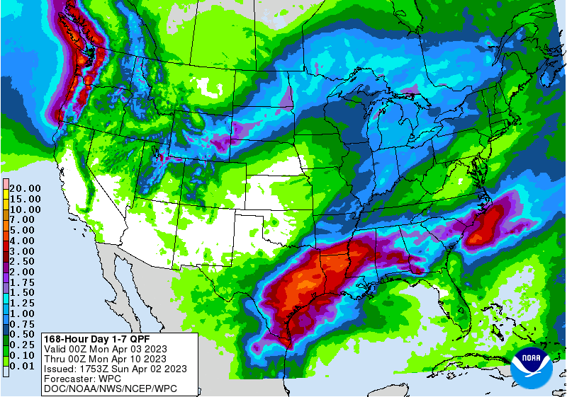
College Station could get several inches of rain this week. Houston as well.
Stratton20
Posts: 4244
Joined: Tue Feb 09, 2021 11:35 pm
Location: College Station, Texas
Contact:

DoctorMu euro and GFS both give CS a ton of rain , pretty good agreement
Attachments
C7BCAAB8-66FF-4DC8-ACE6-F7130A021854.png
5782C4DD-C211-44D6-9A74-1FFDEF329815.png
TexasBreeze
Posts: 942
Joined: Sun Sep 26, 2010 4:46 pm
Location: NW Houston, TX
Contact:

Glad that phpBB server issue is resolved on here and S2k! There was no plan C for seeing posts since both sites were out.
Cpv17
Posts: 5285
Joined: Fri Aug 31, 2018 1:58 pm
Location: El Campo/Wharton
Contact:

TexasBreeze wrote: Sun Apr 02, 2023 1:36 pm Glad that phpBB server issue is resolved on here and S2k! There was no plan C for seeing posts since both sites were out.
How do you know what happened?
User avatar
don
Posts: 2611
Joined: Wed Feb 03, 2010 3:33 pm
Location: Heights
Contact:

The 12Z Euro. The Euro has been pretty consistent with the front stalling around the I-59 corridor.
Screenshot 2023-04-02 at 13-53-13 Models ECMWF Hi-Res — Pivotal Weather.png
User avatar
srainhoutx
Site Admin
Site Admin
Posts: 19615
Joined: Tue Feb 02, 2010 2:32 pm
Location: Maggie Valley, NC
Contact:

Cpv17 wrote: Sun Apr 02, 2023 1:54 pm
TexasBreeze wrote: Sun Apr 02, 2023 1:36 pm Glad that phpBB server issue is resolved on here and S2k! There was no plan C for seeing posts since both sites were out.
How do you know what happened?
It happened. Glad both sites are back up and running smoothly!
Carla/Alicia/Jerry(In The Eye)/Michelle/Charley/Ivan/Dennis/Katrina/Rita/Wilma/Humberto/Ike/Harvey

Member: National Weather Association
Facebook.com/Weather Infinity
Twitter @WeatherInfinity
Stratton20
Posts: 4244
Joined: Tue Feb 09, 2021 11:35 pm
Location: College Station, Texas
Contact:

Interesting to see global models consistently spitting out pretty high rain fall totals for the region, will be very interesting to see the mesoscale model outputs once they get into range, stalled fronts almost always spell flooding issues around here even with dry grounds
User avatar
DoctorMu
Posts: 5669
Joined: Sun Jun 28, 2015 11:58 am
Location: College Station
Contact:

Stratton20 wrote: Sun Apr 02, 2023 1:35 pm DoctorMu euro and GFS both give CS a ton of rain , pretty good agreement
Count me as highly skeptical. If the front stalls over CLL, then maybe.

This has been one of those springs where the energy has been ripping east and north of here. Houston will see significant rain on the stalled front.

NOAA dropped rain chances later in the week for CLL to 50%, peaking at 70% Thursday night. 80-90% in Houston for days.
User avatar
DoctorMu
Posts: 5669
Joined: Sun Jun 28, 2015 11:58 am
Location: College Station
Contact:

I know y'all want to wishcast a lot of rain for CLL this week. My decades of living here and observing spring/severe weather patterns says hold my beer.

Image

aka broken line of showers...
Cpv17
Posts: 5285
Joined: Fri Aug 31, 2018 1:58 pm
Location: El Campo/Wharton
Contact:

Stratton20 wrote: Sun Apr 02, 2023 1:35 pm DoctorMu euro and GFS both give CS a ton of rain , pretty good agreement
Yeah, I agree. I think it’s almost a lock at this point.
Cpv17
Posts: 5285
Joined: Fri Aug 31, 2018 1:58 pm
Location: El Campo/Wharton
Contact:

Looks pretty good:

Image
Stratton20
Posts: 4244
Joined: Tue Feb 09, 2021 11:35 pm
Location: College Station, Texas
Contact:

Havent see those colors in a long time! Beautiful!! Also the WPC has a 2/4 or slight risk of excessive rainfall at the day 5 outlook for most of SE Texas
User avatar
DoctorMu
Posts: 5669
Joined: Sun Jun 28, 2015 11:58 am
Location: College Station
Contact:

We'll see. I think I-10 and south are a lock.

NWS weekend crew is betting on the location of the stalled front in 4-6 days. That forecast could change tomorrow and Tuesday.
User avatar
DoctorMu
Posts: 5669
Joined: Sun Jun 28, 2015 11:58 am
Location: College Station
Contact:

Most of the rain I'm seeing in CLL on the Ensembles, Euro, GFS are dependent on disturbances riding the front and SJT in a Thursday night - Monday time frame on the cold side, rather than the initial passage or warm sector.

CMC sees a lot less of the back door stuff after FROPA. We're days away - it should be interesting.
Cpv17
Posts: 5285
Joined: Fri Aug 31, 2018 1:58 pm
Location: El Campo/Wharton
Contact:

The EPS just trended even wetter for southeast TX.
User avatar
DoctorMu
Posts: 5669
Joined: Sun Jun 28, 2015 11:58 am
Location: College Station
Contact:

Tornado radar couplet near Marlin, NNW of CLL on Hwy 6.
User avatar
DoctorMu
Posts: 5669
Joined: Sun Jun 28, 2015 11:58 am
Location: College Station
Contact:

Cpv17 wrote: Sun Apr 02, 2023 5:28 pm The EPS just trended even wetter for southeast TX.
Heavy gradient SE of Hwy 1*5.

Image
Stratton20
Posts: 4244
Joined: Tue Feb 09, 2021 11:35 pm
Location: College Station, Texas
Contact:

GFS still has 5 inches for me, bring it on!
Post Reply
  • Information