
And it’s raining there yet again..
May 2023

Potent storm cell moving south into the city.

Santa Fe high and dry 

-
Iceresistance
- Posts: 577
- Joined: Fri Apr 30, 2021 11:48 pm
- Location: Tecumseh, OK
- Contact:
Unless this builds more west in a hurry this will miss east of me.
Me too which I’ll ok with.
-
Stratton20
- Posts: 4248
- Joined: Tue Feb 09, 2021 11:35 pm
- Location: College Station, Texas
- Contact:
Big fat nothing burger here ( in katy)
Yeah the storms are starting to weaken quite a bit. There was almost nothing south of I-10 today. Tomorrow’s another day.
-
Stratton20
- Posts: 4248
- Joined: Tue Feb 09, 2021 11:35 pm
- Location: College Station, Texas
- Contact:
I dont like the trend for tommorow either, alot of the mesocale model guidance no longer has the surface low or has shifted farther east with it
18z HRRR shifted most of the rain tommorow into the gom or far east texas
18z Euro has shifted most of the rain offshore or in east texas,
rain chances in my opinion are going down tommorow, its not looking good
18z HRRR shifted most of the rain tommorow into the gom or far east texas
18z Euro has shifted most of the rain offshore or in east texas,
rain chances in my opinion are going down tommorow, its not looking good
Last edited by Stratton20 on Mon May 08, 2023 8:29 pm, edited 1 time in total.
The ole I-10 wall doing work.

Picked up 0.95” here. And we made it to dinner.
Remember not to put too much stock into individual model runs.The forecast is complicated due to the mesoscale driven nature of the pattern.The 0Z HRRR already flipped back wet.The HRRR has the low really cranking up Wednesday showing a bullseye of over 18" of rain in Brazoria county FWIW.(probably overdone)Its anyone's guess where the exact location of these rainfall bulleyes end up being.Stratton20 wrote: ↑Mon May 08, 2023 8:06 pm I dont like the trend for tommorow either, alot of the mesocale model guidance no longer has the surface low or has shifted farther east with it
18z HRRR shifted most of the rain tommorow into the gom or far east texas
18z Euro has shifted most of the rain offshore or in east texas,
rain chances in my opinion are going down tommorow, its not looking good
Last edited by don on Mon May 08, 2023 9:20 pm, edited 2 times in total.
-
Iceresistance
- Posts: 577
- Joined: Fri Apr 30, 2021 11:48 pm
- Location: Tecumseh, OK
- Contact:
Nothing for me, but that was expected.


Tuesday could be interesting.
-
Stratton20
- Posts: 4248
- Joined: Tue Feb 09, 2021 11:35 pm
- Location: College Station, Texas
- Contact:
HRRR 00z has a max bullseye of 26 inches, i think thats way overdone to be fair
Just the fact that it wasn’t supposed to rain Sunday should tell us that it’s hard to know what to expect. Seeing high amounts on some of the mesoscale and HI RES model is a concern
A lot of damage in my neighborhood, a little west of Beaumont. We were in a tornado warning. We actually had 2 warnings for my area, back to back. I'm not sure if it was a tornado or just high winds, but the wind was howling! We lost power at 3:10pm. The first estimate for restoration was 5:30pm, then 10pm, then 4pm tomorrow, and now 10pm tomorrow and some people think it may even be extended beyond that. There was massive damage to the Entergy equipment and many downed lines. In my neighborhood, someone posted a pic of a trampoline in their pool and said they don't own a trampoline. Lots of tables and chairs, trash cans, outdoor toys and equipment tossed around. Another trampoline is in a ditch. A mailbox is in a ditch numbered 446 and the house it's in front of is 1106. Lots and lots of uprooted trees, trees snapped in half, trees blocking streets and driveways, not to mention branches and debris everywhere. A neighbor said his truck was lifted off the ground and dropped back down. Neighbors are saying it's the worst storm they've experienced here. A lady I know was under her desk with her dog for nearly an hour because she was so scared. We were in the hallway with our pets listening to trees snap, not knowing if one was about to fall on us. I love stormy weather, but even I was scared. Tonight, we're playing cards and board games by candlelight and everyone is ok.
I’m so glad you are OK. Wow. Sounds like some serious damage over there. I hope everyone is OK.
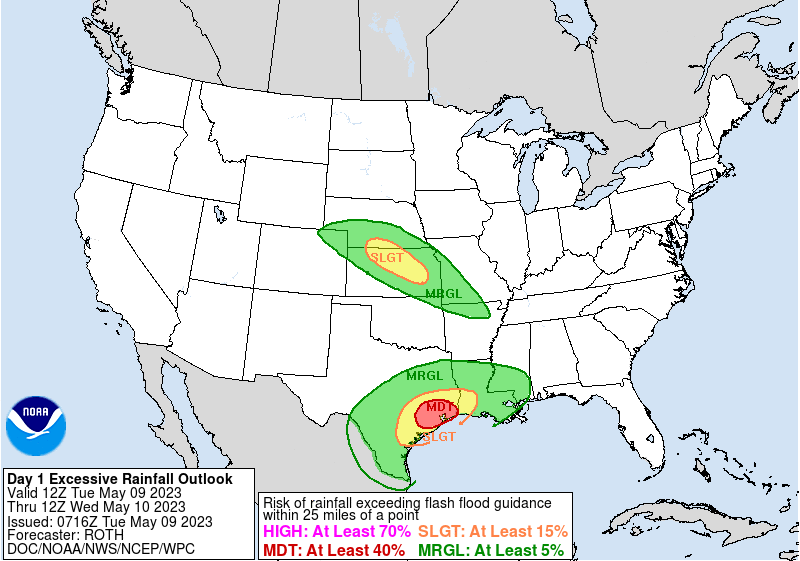
Upgraded to moderate:
And tomorrow as well:
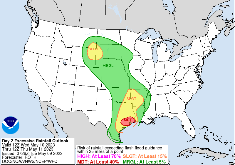
And tomorrow as well:
A couple hours behind schedule but round 1 on the way.
