
August 2023
-
Stratton20
- Posts: 4248
- Joined: Tue Feb 09, 2021 11:35 pm
- Location: College Station, Texas
- Contact:
Don thats interesting, definitely gotta watch and see if a wave gets into the gulf , its been so quiet this season so far and already social media is going off with the typical dramatic seasons a bust posts, IMO august or mid to late August is when the true hurricane season begins
August 20th is the exact date to when peak season begins.Stratton20 wrote: ↑Fri Aug 04, 2023 8:59 pm Don thats interesting, definitely gotta watch and see if a wave gets into the gulf , its been so quiet this season so far and already social media is going off with the typical dramatic seasons a bust posts, IMO august or mid to late August is when the true hurricane season begins
With the (overall) dry summers both this year and last, I've noticed a new species of cockroach in additon to the typical "American" types. These new species look like "Suriname" roaches, and they emerge quite readily after thorough soaking of a dry yard.

105°F today and another record buster.
Still looking like a transition in the August 15-18 and hopefully beyond. Showers begin to gather in the GoM and a Rip Van Winkle awakening of scattered showers locally?
The pot is definitely boiling.
And the ridge begins to weaken. Climo may finally be on our side, but eyes need to be on the Gulf.
July and early August are often quiet.
Heat index of 100°F at 10 pm.
That is so wrong.
That is so wrong.
-
vci_guy2003
- Posts: 203
- Joined: Mon Jun 28, 2010 4:04 am
- Contact:
I remember during the summer of 2011 the actual air temp was still 99 degrees at love field at Midnight. That was insane.
You know it's a bad summer when even deep into Louisiana is seeing routine 100°F+ temps. Data for Lake Charles, Alexandria, and Baton Rogue shows that they are all firmly in the cooker. the cooker. Even Slidell, New Orleans, and coastal MS have been getting in on the heat and dryness a bit.
It's mainly Alabama/Florida then the eastern seaboard Southern states (Georgia and Carolinas) that do very well with summer rainfall the past few years: it's the constatn troughing from the Midwest/East Coast that extends down those areas to give them action.
It's mainly Alabama/Florida then the eastern seaboard Southern states (Georgia and Carolinas) that do very well with summer rainfall the past few years: it's the constatn troughing from the Midwest/East Coast that extends down those areas to give them action.
That said, the ridge as of next week doesn't really have the "bubble formation grip" over TX as per last nights models: instead, it had more an "elongated" configuration from Baja then to Gulf Coast (as per CMC and GFS), before pivoting northwest by the next weekened period to "open the Gulf" (as per GFS and EURO, but CMC instead pivots the ridge to the SE US).
No chance in hell I'm staying in Houston (or Texas) any longer than I have to for work. Our weather absolutely sucks for half of the year every year.
Yea, this is beyond irritating now. Every time there’s a hint of rain or even clouds 8-10 days out. It just continues with the 102+ oven. It seems like we are on course for 3 straight months of scorching heat without anything other than a random shower for a lucky few.
The soil temp is 93 degrees where I am and the 10 year avg is 87..
https://www.greencastonline.com/tools/soil-temperature
Just type your zip^
College station is at 107 degrees. 10 year avg is 98!
The soil temp is 93 degrees where I am and the 10 year avg is 87..
https://www.greencastonline.com/tools/soil-temperature
Just type your zip^
College station is at 107 degrees. 10 year avg is 98!
I lived in Red Stick for awhile. It never reach 100°F. 96°F was a really, really hot day there.user:null wrote: ↑Sat Aug 05, 2023 9:11 am You know it's a bad summer when even deep into Louisiana is seeing routine 100°F+ temps. Data for Lake Charles, Alexandria, and Baton Rogue shows that they are all firmly in the cooker. the cooker. Even Slidell, New Orleans, and coastal MS have been getting in on the heat and dryness a bit.
It's mainly Alabama/Florida then the eastern seaboard Southern states (Georgia and Carolinas) that do very well with summer rainfall the past few years: it's the constatn troughing from the Midwest/East Coast that extends down those areas to give them action.
Last edited by DoctorMu on Sat Aug 05, 2023 8:06 pm, edited 1 time in total.
Current soil temp. in College Station is 117°F (that is not a typo) No wonder my grass is dying (despite the watering and my best efforts). As soon as the sun lowers it more Sta-Green Max fertilizer and major watering.. The ground is completely desiccated.davidiowx wrote: ↑Sat Aug 05, 2023 1:14 pm Yea, this is beyond irritating now. Every time there’s a hint of rain or even clouds 8-10 days out. It just continues with the 102+ oven. It seems like we are on course for 3 straight months of scorching heat without anything other than a random shower for a lucky few.
The soil temp is 93 degrees where I am and the 10 year avg is 87..
https://www.greencastonline.com/tools/soil-temperature
Just type your zip^
College station is at 107 degrees. 10 year avg is 98!
The summer weather in SETX (and this is going to become the norm) is the only thing that has me thinking about retirement...and moving back to NC if I can afford it.
I'm in a real 1883 mood!

This heat is suffocating. I hope the grid hold up this week as the temp highs are in the 100s.
Today’s CPC forecast was the best I’ve seen in a while. Finally brings rain back in here around mid month. Goes along with what I’ve been thinking for the past week now.
-
Stratton20
- Posts: 4248
- Joined: Tue Feb 09, 2021 11:35 pm
- Location: College Station, Texas
- Contact:
Yep that CPC outlook is nice! Also the 18z gfs has a weak depression hovering off the deep south texas coast at day 9-10 fwiw, but then begins to lift north and strengthens into a tropical storm as it heads for the middle texas coast
Yes, GFS offers hope, but was remarkably retrained in not offering a CAT4. A less organized system, here that merges with a FROPA, could bring more widespread rain with less flooding.
Let’s pray this validates
- Attachments
-


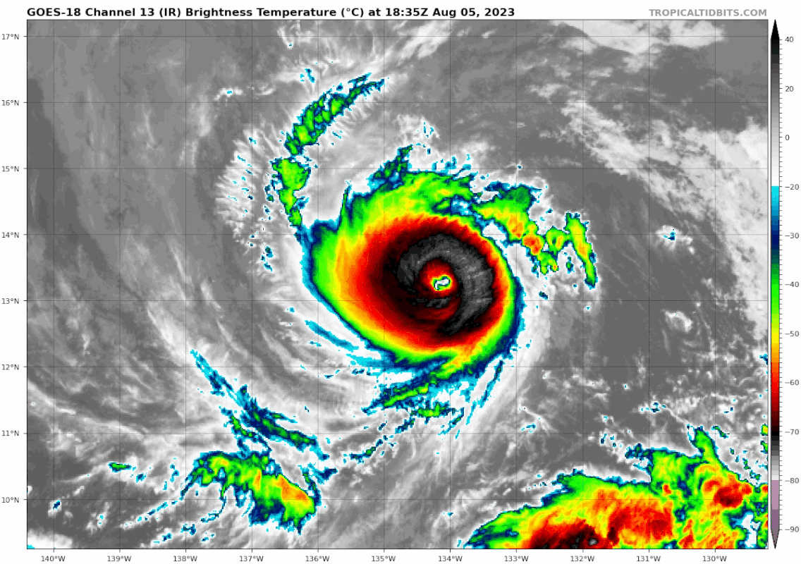
A bit off topic. Hurricane Dora is a Category 4 annular hurricane.
https://www.nhc.noaa.gov/text/refresh/M ... 0240.shtml
https://www.nhc.noaa.gov/text/refresh/M ... 0240.shtml
Code: Select all
000
WTPZ35 KNHC 060240
TCPEP5

BULLETIN
Hurricane Dora Advisory Number  23
NWS National Hurricane Center Miami FL       EP052023
500 PM HST Sat Aug 05 2023

...DORA EVEN STRONGER AS IT TAKES ON ANNULAR CHARACTERISTICS...
...FORECAST TO MOVE INTO THE CENTRAL PACIFIC BASIN ON SUNDAY...


SUMMARY OF 500 PM HST...0300 UTC...INFORMATION
----------------------------------------------
LOCATION...13.2N 136.5W
ABOUT 1335 MI...2145 KM ESE OF SOUTH POINT HAWAII
ABOUT 1865 MI...3005 KM WSW OF THE SOUTHERN TIP OF BAJA CALIFORNIA
MAXIMUM SUSTAINED WINDS...145 MPH...230 KM/H
PRESENT MOVEMENT...W OR 265 DEGREES AT 18 MPH...30 KM/H
MINIMUM CENTRAL PRESSURE...942 MB...27.82 INCHES


WATCHES AND WARNINGS
--------------------
There are no coastal watches or warnings in effect.


DISCUSSION AND OUTLOOK
----------------------
At 500 PM HST (0300 UTC), the center of Hurricane Dora was located
near latitude 13.2 North, longitude 136.5 West.  Dora is moving
toward the west near 18 mph (30 km/h).  A westward motion at a
faster forward speed is expected during the next few days.  On the
forecast track, the center of Dora is expected to move into the
central Pacific basin Sunday morning.

Maximum sustained winds have increased to near 145 mph (230 km/h)
with higher gusts.  Dora is a category 4 hurricane on the
Saffir-Simpson Hurricane Wind Scale.  Fluctuations in intensity are
possible during the next day or so, followed by only gradual
weakening through the early part of next week.

Hurricane-force winds extend outward up to 25 miles (35 km) from the
center and tropical-storm-force winds extend outward up to 60 miles
(95 km).

The estimated minimum central pressure is 942 mb (27.82 inches).


HAZARDS AFFECTING LAND
----------------------
None.


NEXT ADVISORY
-------------
Next complete advisory at 1100 PM HST.

$$
Forecaster Berg-
- Information
-
Who is online
Users browsing this forum: Ahrefs [Bot], Amazon [Bot], jasons2k and 68 guests