

Correct - this event was progged by Ensembles, Euro, GFs to be north of Hwy 1*5, much less I-10.jasons2k wrote: ↑Thu Sep 14, 2023 10:04 pmI know the feeling, but in fairness, nobody called for a 100% chance of rain. And the most of the models I saw showing that much were mostly north of I-10, and that was still going out forward a few more days from now.
We have another disturbance coming across overnight and then a recharge with another disturbance tomorrow. There may be also a decent shot on Saturday depending on how things play out. This event isn't over yet and already a lot of of folks have seen more rain in the last couple of days than they have seen all summer.
I know it's frustrating so far - I have been there so many times - but eventually you will see rain again and some day soon with El Nino here - you'll even be telling us about all the swampy muck and mosquitos.
September 2023
As the Great Lakes trough slips each the SJt has picked up dry air at the mid levels - so we have a cap N of HWY 1*5. From Navasota south should see additional rain.
https://www.star.nesdis.noaa.gov/GOES/c ... &length=24
Next week a baby DR establishes itself with zonal flow, but weaker ridging and lower sun angle will yield 90s instead of 100s. Then a potential ULL from the Rockies in 10 days, although that is uncertain. 8-14 day forcasts are for above normal temperatures and "normal" precip.
It's tomorrow morning or bust for us, although we did see a few showers early this morning - just not a lot of accumulation.
I already need to order a dump truck of soil to begin replacing my dead yard since it refuses to rain at all anywhere remotely near me, and the chinch bugs are immune to any pesticide I use. This entire year sucks.jasons2k wrote: ↑Thu Sep 14, 2023 10:04 pmI know the feeling, but in fairness, nobody called for a 100% chance of rain. And the most of the models I saw showing that much were mostly north of I-10, and that was still going out forward a few more days from now.
We have another disturbance coming across overnight and then a recharge with another disturbance tomorrow. There may be also a decent shot on Saturday depending on how things play out. This event isn't over yet and already a lot of of folks have seen more rain in the last couple of days than they have seen all summer.
I know it's frustrating so far - I have been there so many times - but eventually you will see rain again and some day soon with El Nino here - you'll even be telling us about all the swampy muck and mosquitos

Big storm complex out in the Hill Country - something to keep an eye on.
-
captainbarbossa19

- Posts: 401
- Joined: Mon Jun 28, 2021 2:50 pm
- Location: Starkville, MS
- Contact:
I wouldn't pay much attention to an outlook that far in advance. We are getting into a time of year where the pattern will start becoming more dynamic so the predictability at that range will become more uncertain as we head deeper into fall. I think we will really begin to see a full weather pattern transition as we head into October and November.DoctorMu wrote: ↑Thu Sep 14, 2023 10:23 pm As the Great Lakes trough slips each the SJt has picked up dry air at the mid levels - so we have a cap N of HWY 1*5. From Navasota south should see additional rain.
https://www.star.nesdis.noaa.gov/GOES/c ... &length=24
Next week a baby DR establishes itself with zonal flow, but weaker ridging and lower sun angle will yield 90s instead of 100s. Then a potential ULL from the Rockies in 10 days, although that is uncertain. 8-14 day forcasts are for above normal temperatures and "normal" precip.
It's tomorrow morning or bust for us, although we did see a few showers early this morning - just not a lot of accumulation.
-
Stratton20
- Posts: 4248
- Joined: Tue Feb 09, 2021 11:35 pm
- Location: College Station, Texas
- Contact:
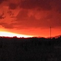
Pretty decent line of storms approaching my area from the west

Beaumont getting hammered.
Been watching all morning.
- Attachments
-
That line better dig south.

Flash Flood Warning
Flash Flood Warning
TXC245-152145-
/O.NEW.KLCH.FF.W.0030.230915T1839Z-230915T2145Z/
/00000.0.ER.000000T0000Z.000000T0000Z.000000T0000Z.OO/
BULLETIN - EAS ACTIVATION REQUESTED
Flash Flood Warning
National Weather Service Lake Charles LA
139 PM CDT Fri Sep 15 2023
The National Weather Service in Lake Charles has issued a
* Flash Flood Warning for...
North Central Jefferson County in southeastern Texas...
* Until 445 PM CDT.
* At 139 PM CDT, Doppler radar indicated thunderstorms producing
heavy rain across the warned area. Between 1 and 3 inches of rain
have fallen. Additional rainfall amounts up to 1 inch are possible
in the warned area. Flash flooding is ongoing or expected to begin
shortly.
HAZARD...Flash flooding caused by thunderstorms.
SOURCE...Radar.
IMPACT...Flash flooding of small creeks and streams, urban
areas, highways, streets and underpasses as well as
other poor drainage and low-lying areas.
* Some locations that will experience flash flooding include...
Beaumont.
PRECAUTIONARY/PREPAREDNESS ACTIONS...
Turn around, don`t drown when encountering flooded roads. Most flood
deaths occur in vehicles.
Be aware of your surroundings and do not drive on flooded roads.
&&
LAT...LON 3001 9414 3005 9419 3009 9419 3011 9419
3013 9416 3009 9410 3005 9408
FLASH FLOOD...RADAR INDICATED
$$
78
Flash Flood Warning
TXC245-152145-
/O.NEW.KLCH.FF.W.0030.230915T1839Z-230915T2145Z/
/00000.0.ER.000000T0000Z.000000T0000Z.000000T0000Z.OO/
BULLETIN - EAS ACTIVATION REQUESTED
Flash Flood Warning
National Weather Service Lake Charles LA
139 PM CDT Fri Sep 15 2023
The National Weather Service in Lake Charles has issued a
* Flash Flood Warning for...
North Central Jefferson County in southeastern Texas...
* Until 445 PM CDT.
* At 139 PM CDT, Doppler radar indicated thunderstorms producing
heavy rain across the warned area. Between 1 and 3 inches of rain
have fallen. Additional rainfall amounts up to 1 inch are possible
in the warned area. Flash flooding is ongoing or expected to begin
shortly.
HAZARD...Flash flooding caused by thunderstorms.
SOURCE...Radar.
IMPACT...Flash flooding of small creeks and streams, urban
areas, highways, streets and underpasses as well as
other poor drainage and low-lying areas.
* Some locations that will experience flash flooding include...
Beaumont.
PRECAUTIONARY/PREPAREDNESS ACTIONS...
Turn around, don`t drown when encountering flooded roads. Most flood
deaths occur in vehicles.
Be aware of your surroundings and do not drive on flooded roads.
&&
LAT...LON 3001 9414 3005 9419 3009 9419 3011 9419
3013 9416 3009 9410 3005 9408
FLASH FLOOD...RADAR INDICATED
$$
78
Mike
Beaumont, TX
(IH-10 & College Street)
Beaumont, TX
(IH-10 & College Street)
I’ll tell you this, it’s awfully hot and humid out there. Seems like a lot of available fuel out there for storms to work with.
-
GBinGrimes
- Posts: 108
- Joined: Mon Jan 27, 2014 1:50 pm
- Location: Anderson, TX
- Contact:
Getting absolutely hammered in Grimes County. Welcome sight, but there's going to be a lot of trees and limbs that were hanging on for dear life during the drought that will be strewn across county roads after this.
Not where I live. We’ve had a lot of fairly comfortable days at my location regarding the humidity. It’s extra juicy out there today where I’m at, though.

That was a storm.
Caught in it on 99 headed towards Tomball.
Wow.
Caught in it on 99 headed towards Tomball.
Wow.
Day 2.
- Attachments
-
Geez the Cypress area gets skipped over again.
Gonna be a close call for Cromagnum.
Gonna be a close call for Cromagnum.

Beautiful radar right now. 

Last edited by don on Fri Sep 15, 2023 4:06 pm, edited 1 time in total.
That’s why we need the like button.