

October 2023
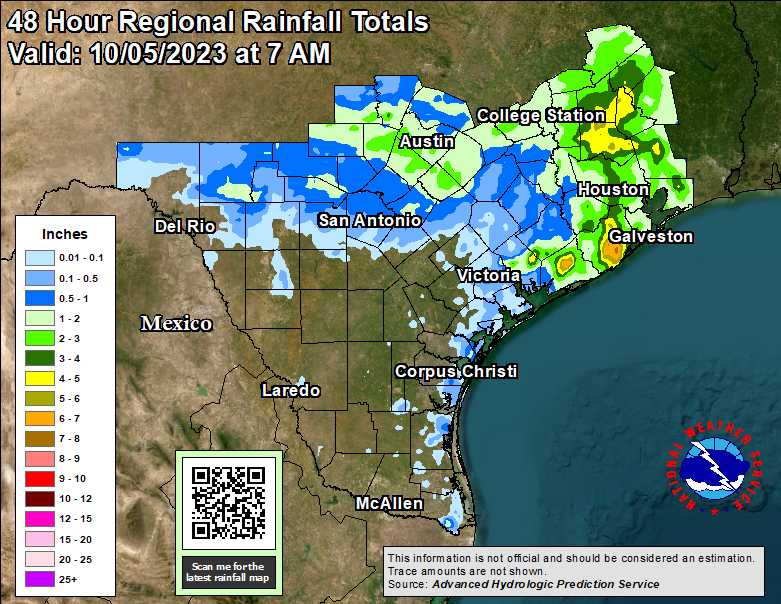
Between 1 - 2 inches of delicious rain here. I have to get an exact total. Very welcome!
Picked up .20” yesterday and 2.62” this morning. Finally got a good rain!
-
Stratton20
- Posts: 4248
- Joined: Tue Feb 09, 2021 11:35 pm
- Location: College Station, Texas
- Contact:
GFS 18z has another decently strong fall front in about 8 days, welcome to real fall folks! Courtesy of el nino
 Courtesy of el nino
I recorded 7.68" total
Mosquitoes were kicking my tail this evening as I finished up my dirt work. They are going to be horrible this weekend.
-
Stratton20
- Posts: 4248
- Joined: Tue Feb 09, 2021 11:35 pm
- Location: College Station, Texas
- Contact:
Their is a secondary front moving in tommorow night, that is the one that brings in the fall air, those mosquitoes will not be around long

I second thatTexasBreeze wrote: ↑Thu Oct 05, 2023 5:07 pm Lots of good talk about the seasons future and pattern recognition in the Texas weather thread on S2K today! Definitely worth the read!
-
redneckweather
- Posts: 1023
- Joined: Mon Feb 08, 2010 7:29 pm
- Location: Montgomery, Texas
- Contact:
Global Warming.Stratton20 wrote: ↑Thu Oct 05, 2023 5:53 pm GFS 18z has another decently strong fall front in about 8 days, welcome to real fall folks!
-
Stratton20
- Posts: 4248
- Joined: Tue Feb 09, 2021 11:35 pm
- Location: College Station, Texas
- Contact:
ignoring the troll comment above, the push of cooler air should probably arrive tonight or early saturday morning
Today is sunny and warmish. The weekend should be bluebird sky and cool.
A perfect weekend coming up. A warmup late next week to near 90°F before...

That would be a shame.
That would be a shame.
-
tireman4

- Global Moderator

- Posts: 4488
- Joined: Wed Feb 03, 2010 9:24 pm
- Location: Humble, Texas
- Contact:
00
FXUS64 KHGX 061752
AFDHGX
Area Forecast Discussion
National Weather Service Houston/Galveston TX
Issued by National Weather Service Tallahassee FL
1252 PM CDT Fri Oct 6 2023
...New AVIATION...
.UPDATE...
Issued at 1040 AM CDT Fri Oct 6 2023
No major changes to today`s forecast were required. The only
notable adjustment was refreshing the sky cover forecast based on
current satellite trends where a developing fair-weather cumulus
field is underway with a weakening stratus deck near the coast.
High clouds will stream in through the afternoon off the Mexican
Plateau.
&&
.SHORT TERM...
(Today through Saturday Night)
Issued at 343 AM CDT Fri Oct 6 2023
Tranquil and pleasant weather conditions are expected for the next
few days as a broad surface high pressure builds over the Southern
Plains today and then progresses into Texas on Saturday. Conditions
will be breezy in response to a low level jet that is to start
developing over Southeast Texas this morning and remain in place on
Saturday. Expect north to northeast winds at 10 to 15 mph with
higher gusts on occasion on both days.
For today, expect cloudy to partly cloudy skies with high
temperatures in the low to mid 80s areawide. The lows tonight will
be a few degrees lower, ranging in the upper 50s over the Brazos
Valley and Piney Woods region, the low to mid 60s over the rest of
the inland portions, and in the upper 60s to low 70s along the
immediate coasts and Barrier Islands.
On Saturday, additional CAA will bring down the temperatures a
little more. The highs will be in the low to mid 70s over areas
north of I-10 and in the mid to upper 70s along and south of I-10.
And...I can`t believe I`m saying this but, YES, we are finally going
to see temperatures dipping in the 50s for much of Southeast Texas
late Saturday night into early Sunday morning! Our current forecast
carries lows in the upper 40s for the Piney Woods region, the low to
mid 50s for areas north of I-10, the mid 50s for areas along and
south of I-10, and in the low 60s for the Barrier Islands. On top of
that, the dewpoints will decrease into the 30s and 40s inland and
the 50s along the coasts. A nice and crisp kind of morning...perfect
for sipping hot chocolate at the patio while starring at squirrels
or time to dust off those shoes and go for a nice walk/jog/bike ride
along your favorite route.
Enjoy Southeast Texas!
&&
.LONG TERM...
(Sunday through Thursday)
Issued at 343 AM CDT Fri Oct 6 2023
Okay, so, all that stuff above about patios, hot chocolate,
squirrels, and biking from the end of the short term? Yup, more
of that Sunday! While we`re still more in northwest flow,
transition from trough to ridge at midlevels, ridging otherwise
reigns, with a surface high focused...not that far to the
northwest of College Station in our northwest corner. Expect the
coolest temperatures we`ve seen in...months, really...for most of
the area Sunday morning around dawn. That will warm pretty
effectively underneath the early October sun, so Sunday looks to
be ever so slightly warmer than Saturday despite the cool start.
Sunday night/Monday morning also should be pretty cool. Though
guidance is now bringing the surface high across our area through
Sunday/Sunday evening, and so we may start to pick up at least
partially onshore flow late Sunday night into Monday morning.
Because of that, I keep those low temps still quite cool but a
touch warmer, and from there we`re back on the warming track. So
hopefully you make the most of this weekend, as what happens this
weekend looks like it`s going to stay in this weekend.
The first half of the week should feature some light ridging
aloft, but also some signs of getting some shortwave troughs
running through the pattern to keep the magnitude of any ridging
dampened. At the surface, high pressure will drift off to the
east, establishing persistent onshore flow. Towards the mid-week,
a new upper trough is going to make its way across the Rockies,
and we`ll get surface low development out in the Panhandle/NM/CO
area, tightening the pressure gradient and enhancing that onshore
flow. This will push us through temperatures near seasonal
averages in the early week to above-average, more summerish
(emphasis on the ish) conditions for the mid and late week.
Fair weather will dominate the end of the weekend and early week,
but as moisture return builds through the week, rain chances will
also begin to move their way back in. Slight chances work in as
early as Tuesday afternoon, though that`s entirely south of I-10,
and even there, I wouldn`t expect much coverage, if any at all.
The chances are slight for a reason. Better chances show up
Wednesday and Thursday in advance of our next cold front making
its way in, attached to the aforementioned Plains low. We`ll
continue to have to watch the behavior of Lidia and a following
disturbance in the East Pacific. Not so much for explicit tropical
cyclone action in the Gulf, but more just for contributing
moisture and vorticity crossing the western Gulf to boost rains on
the Gulf waters and possibly bleeding onto the coast. For now, the
trend continues to be our friend, keeping heaviest rains well
offshore, and allowing only for lighter rains at most at the
coast.
&&
.AVIATION...
(18Z TAF Issuance)
Issued at 1241 PM CDT Fri Oct 6 2023
The main aviation concerns this aftn are breezy winds sustained
around 12 kts with gusts often in excess of 20 kts. Winds
temporarily ease early this evening, but pick back up overnight
into the early AM. A few sites aim towards sustained winds closer
to 15 kts by mid-morning, especially closer to the coast where
KGLS is fcst to be about 20 kts (gusts > 25 kts). Otherwise, VFR
conds should prevail under mostly SCT-BKN high cloud cover.
&&
.MARINE...
Issued at 343 AM CDT Fri Oct 6 2023
Moderate north and northeast winds prevail today in the wake of
yesterday`s storms and frontal passage. A reinforcing front
pushes across the waters tonight, boosting winds and seas. Cooler,
drier air moving over the warm coastal waters will lead to north
winds increasing to 20 to 30 knots with occasional gusts around
gale force. Additionally, seas will build into the 6 to 10 feet
foot range Friday night and into Saturday afternoon. A Small Craft
Advisory has been issued for this timeframe. Winds and seas
gradually decrease Saturday night and Sunday. Onshore flow returns
by Monday along with chances of rain in the Gulf waters early
next week.
&&
.PRELIMINARY POINT TEMPS/POPS...
College Station (CLL) 85 MMM MMM MMM / 0 0 0 0
Houston (IAH) 85 MMM MMM MMM / 0 0 0 0
Galveston (GLS) 85 MMM MMM MMM / 0 0 0 0
&&
.HGX WATCHES/WARNINGS/ADVISORIES...
TX...None.
GM...Small Craft Should Exercise Caution until 7 PM CDT this evening
for GMZ350-355-370-375.
&&
$$
SHORT TERM...Cotto
LONG TERM....Luchs
AVIATION...WFO TAE
MARINE...Luchs
Not sure that above normal precip forecast the CPC put out for October will verify. Next couple weeks look pretty dry.
-
Stratton20
- Posts: 4248
- Joined: Tue Feb 09, 2021 11:35 pm
- Location: College Station, Texas
- Contact:
Cpv17 eh i dont think so, i see several more fall fronts over the next several weeks, of course its too soon to talk about precipitation, but i definitely do not see it being bone dry, + PNA staying locked over the western us should allow troughs to dive down from the north and reach our area from time to time as long as the PNA doesn’t go too positive
Also shortwaves embedded in the large scale pattern will keep ridging weak and transient, far different outlook thab what we had over the summer
Also shortwaves embedded in the large scale pattern will keep ridging weak and transient, far different outlook thab what we had over the summer

I haven't cut the lawn. It's a deep emerald green for the first time since May.
Will take a pic before applying (busy week) fungicide tomorrow.
What time of day is the front tomorrow?


Typhoon Koinu establishes new Taiwan wind record, sets sights on southeastern China
https://www.accuweather.com/en/hurrican ... na/1584774
213 mph on Orchid Island. It is the second highest wind speed measured. It will have to be verified.
https://www.accuweather.com/en/hurrican ... na/1584774
213 mph on Orchid Island. It is the second highest wind speed measured. It will have to be verified.
-
- Information
-
Who is online
Users browsing this forum: Ahrefs [Bot], Amazon [Bot], Semrush [Bot] and 71 guests