
January 2024
Here come the school districts with their “no school tomorrow” announcements now.

The snowflakes remain tiny, but it's actually been snowing harder.
I suspect the snow is being formed underneath the warm nose... Thus the flakes are tiny. Alternatively, the warm nose is thin. and much of the snowfall is evaporating, but some survives. From the HRRR sounding, it looks like shallow overrun. If it were rain, it would just be a mist.
I suspect the snow is being formed underneath the warm nose... Thus the flakes are tiny. Alternatively, the warm nose is thin. and much of the snowfall is evaporating, but some survives. From the HRRR sounding, it looks like shallow overrun. If it were rain, it would just be a mist.
This upcoming wet period looks much different than previous events. My confidence is pretty high this time around.Stratton20 wrote: ↑Mon Jan 15, 2024 12:03 pm Pattern looking wet? Ill believe it when i see it, models have burned us way too many times….

Yep a classic El nino pattern with a large trough digging into Mexico and becoming cut off.Cpv17 wrote: ↑Mon Jan 15, 2024 2:40 pmThis upcoming wet period looks much different than previous events. My confidence is pretty high this time around.Stratton20 wrote: ↑Mon Jan 15, 2024 12:03 pm Pattern looking wet? Ill believe it when i see it, models have burned us way too many times….


-
Thundersleet
- Posts: 67
- Joined: Thu Dec 22, 2016 12:26 am
- Contact:
My neighborhood, here in Baytown, received snow flurries for over thirty minutes.

Lindner 2:30pm update
Winter Weather Update (Monday 230pm)
Light freezing drizzle/rain and periods of sleet and even a few snow flurries combined with surface temperatures well below freezing are resulting in dangerous icing conditions across the north and western portions of the area…mainly along the northwest of US 59.
Light areas of freezing drizzle and sleet continues over the area but will gradually end from the west to the east late this afternoon and evening. However, accumulations of ice and temperatures well into the 20’s will prevent much if any recovery of the poor roadway conditions. While the main concerns are the bridges and overpasses, even surface streets are reporting light ice accumulations in areas where temperatures have fallen into the mid 20’s…including sidewalks, parking lots, and some roadways. All bridges/overpasses/flyovers/connector ramps should be treated as if they have ice. Extreme caution should be used if traveling into early Tuesday.
Several school districts have announced closures for Tuesday…follow your districts communication platforms.
How quickly area roadways recover on Tuesday will be determined by several factors including, if/when the sun comes out, if surface temperatures reach freezing and for how long, and application of anti-ice methods by transportation agencies. It is likely that conditions will not see any significant improvement until midday Tuesday at the earliest.
Very cold conditions will remain for tonight and again on Wednesday morning with hard freezes likely over much of the area. While there has been a focus on travel and road conditions today…do not disregard the cold and everyone should maintain their cold weather preparations until Wednesday. Dangerous wind chill values will remain in place through Tuesday.
This looks like it could be our biggest rain event since last spring.don wrote: ↑Mon Jan 15, 2024 2:49 pmYep a classic El nino pattern with a large trough digging into Mexico and becoming cut off.Cpv17 wrote: ↑Mon Jan 15, 2024 2:40 pmThis upcoming wet period looks much different than previous events. My confidence is pretty high this time around.Stratton20 wrote: ↑Mon Jan 15, 2024 12:03 pm Pattern looking wet? Ill believe it when i see it, models have burned us way too many times….
gfs_z500a_us_37.png
It’s f$&cking cold!!!!!!! Lol!!!!!
59 had to be shut down over here earlier today. There was a ton of accidents happening.
-
vci_guy2003
- Posts: 203
- Joined: Mon Jun 28, 2010 4:04 am
- Contact:
So it’s not a freezing rain event next week ?
Holy bazookas 
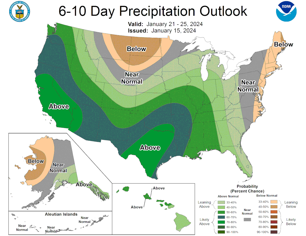
Can’t remember the last time I’ve seen that for our area.

Can’t remember the last time I’ve seen that for our area.

Mike
Beaumont, TX
(IH-10 & College Street)
Beaumont, TX
(IH-10 & College Street)
-
MontgomeryCoWx

- Posts: 2356
- Joined: Wed Dec 14, 2011 4:31 pm
- Location: Weimar, TX
- Contact:
Tail end of it, possibly. Our next big cold dump comes last week of January
Team #NeverSummer
Think we’re gonna have to wait till the end of the month and into February for any significant cold.
-
Stratton20
- Posts: 4248
- Joined: Tue Feb 09, 2021 11:35 pm
- Location: College Station, Texas
- Contact:
I cant recall the last time ive seen those darker shades of green over our neck of the woods
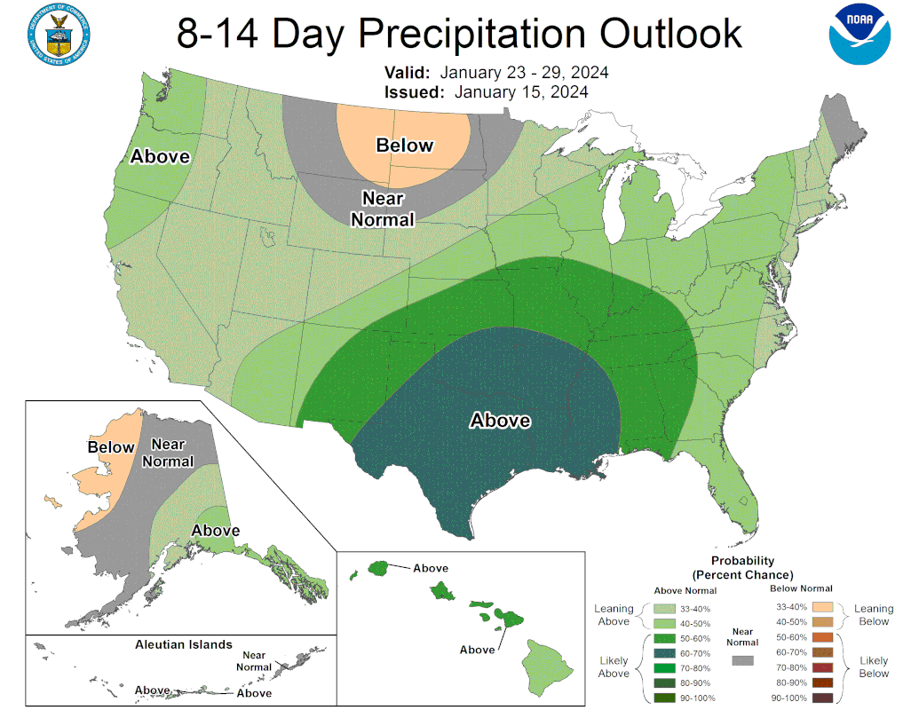
Ensembles have bought in. This will be a cold rain with wintry stuff in north Texas. It won't be a balmy spring rain.

So, no thank you for me! Save it for July!