

The last bit of ice and sleet is gone and fallen victim to sublimation.
I first heard that word from Harold Taft in 1989. Back when TV meteorologists were allowed to explain actual science.
January 2024

Mike
Beaumont, TX
(IH-10 & College Street)
Beaumont, TX
(IH-10 & College Street)


16°F last night with a high of 31°F.
The prognostication that we'd stay below freezing from Sunday at 2 am to Wednesday afternoon is panning out. About 80 consecutive hours below freezing.
The dew point is currently 6°F, so we're going to go pretty low tonight. I'm going to wager 10°F for the low temperature IMBY.
-
MontgomeryCoWx

- Posts: 2356
- Joined: Wed Dec 14, 2011 4:31 pm
- Location: Weimar, TX
- Contact:
Yep, I went below early Sunday morn and Weimar should see around the same amount below freezing. Was certainly not your run of the mill front.DoctorMu wrote: ↑Tue Jan 16, 2024 6:13 pm16°F last night with a high of 31°F.
The prognostication that we'd stay below freezing from Sunday at 2 am to Wednesday afternoon is panning out. About 80 consecutive hours below freezing.
The dew point is currently 6°F, so we're going to go pretty low tonight. I'm going to wager 10°F for the low temperature IMBY.
On a side note, I waited for an Uber in -17 weather this morning. That kind of stung a bit .
Team #NeverSummer
-
CrashTestDummy
- Posts: 187
- Joined: Mon Jul 25, 2016 3:44 pm
- Location: Pearland, Texas
- Contact:
Got to see 19 F this morning. Froze the well. The well guys showed up at ~1030 in 30 F to fix it. Made good time, and not-so-expensive fix. Took until 1600 before the water started running in the kitchen. Well’s now covered, and kitchen faucet it dribbling. I HATE cold weather.
Gene Beaird,
Pearland, Texas
"You can learn a lot from a Dummy."
Pearland, Texas
"You can learn a lot from a Dummy."
Next week has potential for some flash flooding. Watches may be needed.
-
tireman4

- Global Moderator

- Posts: 4488
- Joined: Wed Feb 03, 2010 9:24 pm
- Location: Humble, Texas
- Contact:
000
FXUS64 KHGX 171149
AFDHGX
Area Forecast Discussion
National Weather Service Houston/Galveston TX
549 AM CST Wed Jan 17 2024
...New AVIATION, CLIMATE...
.SHORT TERM...
(Today through Thursday Night)
Issued at 327 AM CST Wed Jan 17 2024
High pressure will drift eastward today, resulting in the return of
onshore flow and WAA. This will end the streak of cold weather
observed the last few days as we see temperatures reach into the 40s
to low 50s. Increasing moisture and cloud cover will limit the
effects of radiational cooling, leaving lows for tonight in the 30s
to 40s.
The warm streak will continue on Thursday as surface high pressure
settles into the SE CONUS and warmer southeasterly flow continues
for SE Texas. Highs for Thursday will be in the 60s area wide. A few
locations in the north may have highs just shy of 60F. Clouds will
increase ahead of another frontal boundary; however with PWAT values
just shy of 1", expecting this front to remain dry. Lows for
Thursday night will be in the 30s to 40s.
Adams
&&
.LONG TERM...
(Friday through Tuesday)
Issued at 327 AM CST Wed Jan 17 2024
In the wake of the cold front, breezy north to northeast winds and
colder temperatures return to the area on Friday as strong high
pressure builds in from the north. High temperatures will range from
the low 40s well inland to the low 50s near/along the coast. This
high will make Friday night`s lows cold once again with readings in
a low to mid 20s range north (Hard Freeze Watches/Warnings will
probably be needed) to the upper 20s to around 30 central to the low
to mid 30s at the coast. Look for gradually warming temperatures in
the Saturday through Wednesday time period, especially Monday
through Wednesday when highs get back into the 60s and possibly 70s
(before the warmer temperatures arrive, there will be one more shot
of subfreezing temperatures Saturday generally to the north of the I-
10 corridor). Coming with the upcoming warming trend will be
returning rain chances at the end of the weekend and increasing
chances Monday through Wednesday as the next storm system slowly
organizes out west and a series of disturbances/impulses move across
the state in an increasingly active southwest flow aloft. The
potential still looks good for a decent part of the area to get
several inches of rain or more in the late Sunday night through the
middle of the week time period.
42
&&
.AVIATION...
(12Z TAF Issuance)
Issued at 533 AM CST Wed Jan 17 2024
Light and variable winds continue this morning, becoming southerly
by this afternoon. VFR prevailing through 00Z before cloud cover
increases, bringing MVFR/IFR CIGs into the area. Southerly winds
will bring an increase in moisture, and with light winds, could
see patchy fog develop overnight into Thursday morning with
MVFR/IFR VSBYs possible.
&&
.MARINE...
Issued at 327 AM CST Wed Jan 17 2024
North to northeast winds this morning will become east to southeast
as the day progresses today. Any remaining abnormally low tides in
and around the northern side of Galveston Bay early this morning
will return more towards normal levels. Increasing south to
southwest winds can be expected tonight and Thursday ahead of the
next cold front. This front will move off the coast and through the
area Thursday night. Strengthening north to northeast winds and
building seas will develop behind this front, and advisories will
likely be needed. Over the weekend, strengthening east winds will
develop and seas will increase, likely resulting in caution and
possible advisory flags. Also look for rain chances to return to the
area at the end of the weekend and to increase into the start of the
new week.
42
&&
.CLIMATE...
Issued at 533 AM CST Wed Jan 17 2024
There were several temperature records that were broken yesterday
(January 16th).
College Station`s low temperature of 17 degrees which set a new low
minimum temperature record (old record was 19 degrees set in 2018).
Houston`s high temperature only reached 34 degrees which set a new
low maximum temperature record (old record was 37 degrees set in
2007). Houston also set a new record low temperature of 18 degrees
(old record was 22 degrees set in 1972).
Houston Hobby`s high temperature only reached 34 degrees which set a
new low maximum temperature record (old record was 38 degrees set in
1984). Houston Hobby also set a new record low temperature of 20
degrees (old record was 25 degrees set in 2018).
Palacios`s high temperature only reached 35 degrees which set a new
low maximum temperature record (old record was 38 degrees set in
2007). Palacios also set a new record low temperature of 20 degrees
(old record was 27 degrees set in 2018).
Here are the record lows and year set for today and Saturday.
Location 17th (Today) 20th (Saturday)
CLL 0(1930) 19(1963)
IAH 15(1930) 20(1985)
HOU 19(2018) 23(1985)
GLS 23(1885) 22(1883)
PSX 21(2018) 23(1963)
If there was a year with a tied record, only
the most recent record year is listed.
42
&&
.PRELIMINARY POINT TEMPS/POPS...
College Station (CLL) 45 33 65 34 / 0 0 0 0
Houston (IAH) 46 39 67 39 / 0 10 0 0
Galveston (GLS) 56 46 64 44 / 0 10 10 0
&&
.HGX WATCHES/WARNINGS/ADVISORIES...
TX...Hard Freeze Warning until 10 AM CST this morning for TXZ163-164-
176>179-195>200-210>214-226-227-235>238-300-313-335>338-
436>439.
Wind Chill Advisory until 10 AM CST this morning for TXZ163-164-
176>179-195>200-210>214-226-227-235>238-300-313-335>338-
436>439.
GM...Low Water Advisory until 6 AM CST early this morning for GMZ335.
&&
$$
SHORT TERM...Adams
LONG TERM....42
AVIATION...Adams
MARINE...42
Waking up to 17 this morning for Beaumont.
Mike
Beaumont, TX
(IH-10 & College Street)
Beaumont, TX
(IH-10 & College Street)
-
brazoriatx
- Posts: 329
- Joined: Tue Nov 08, 2011 12:09 pm
- Contact:
Gotta love it
- Attachments
-
And in the next episode of January Weather Roulette, we will see 70 degree highs tomorrow, soon to be followed by inundating rains next week. Lol. The TX weather memes just make themselves these days, don't they?
Some folks didn’t believe me last week when I said expect a quick warmup and a break between air masses. Some of us old timers have learned a thing or two over the years
18.2 this morning. Looking forward to things getting back to “normal” around here.
-
tireman4
- Global Moderator
- Posts: 4488
- Joined: Wed Feb 03, 2010 9:24 pm
- Location: Humble, Texas
- Contact:
From WXMan 57 over at S2K...
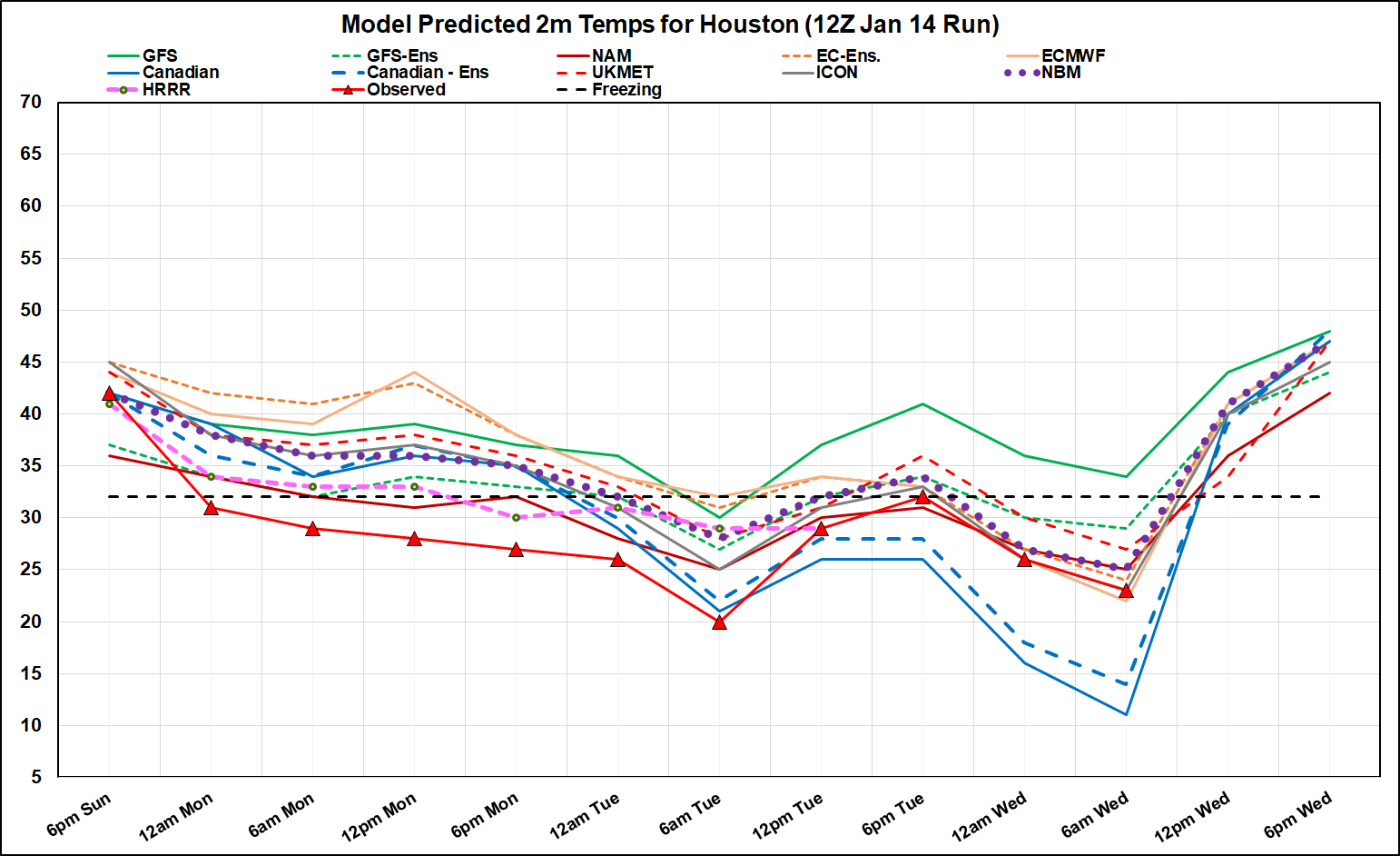
Decided to look at the last model forecast before the front hit Sunday afternoon/evening. Black-bordered red triangles with red line are observed temps over central Houston (downtown). Every model performed badly, but HRRR and NAM were coldest, bringing the sub-freezing temps in MUCH earlier . GFS and Euro operationals were the worst for the first 48 hrs. NBM was generally about 5-7F too warm until yesterday afternoon.
Canadian hit Tuesday's low almost exactly from 48 hrs out. However, it was the worst for this morning's low. It has been forecasting 9F for this morning in every run after 12Z Sunday, even yesterday's run. Euro did best 72 hours out. NBM was still 2F too warm for this morning. GFS was terrible for the whole event.
This morning's low at my house was only 24. It was 20 yesterday morning.
http://wxman57.com/images/Verify.png
NOAA nailed my low of 12°F. NAM was solid in predicting mixed precip. Our local mets had the best record.
57 must live right on the Gulf. He must be addicted to dripping sweat.
We'll rise into the 60s tomorrow briefly with the dry air and SW winds from Mexico (lows are near freezing both nights), then back into the 40s for highs on Friday. Thursday is a Big Bend kinda day weatherwise.
Next week is the big change to an unsettled pattern and rain.
Not all that cold as what prior media hype, fear, etc indicated (i.e. even factoring in the "overperformance" of shallow cold on Monday into Tuesday morning).
Lows both this morning and yesterday (@The Land of Sugar) were two quick dips into 19°F.
IAH dipped briefly into 18°F yesterday morning, but didn't go below 20°F this morning (if the data is clean, waiting to see 12PM update).
Hobby didn't go below 20°F.
So overall, this event (in terms of low temps) still ended up more like 2010, 2011, and 2018 compared to a Feb 2021/Dec 2022 repeat. Actually 16°F was reached at Sugar Land airport in 2010, so this event was not even as bad.
He lives in Westbury.DoctorMu wrote: ↑Wed Jan 17, 2024 10:45 am NOAA nailed my low of 12°F. NAM was solid in predicting mixed precip. Our local mets had the best record.
57 must live right on the Gulf. He must be addicted to dripping sweat.
We'll rise into the 60s tomorrow briefly with the dry air and SW winds from Mexico (lows are near freezing both nights), then back into the 40s for highs on Friday. Thursday is a Big Bend kinda day weatherwise.
Next week is the big change to an unsettled pattern and rain.
This weekend’s cold snap is much more ‘normal’ and manageable for SE Texas. I’m looking forward to next week. Keeping one eye open on February.