

Expect that to go up....
January 2024

What are you talking about? No one including the local media was ever forecasting a February 2021 repeat.The only disagreement we had was that the mesoscale models would end up more accurate than the globals when it comes to temps and precip. Which they were. You seem to want to disagree with us, just to disagree for some reason....user:null wrote: ↑Wed Jan 17, 2024 11:16 am Not all that cold as what prior media hype, fear, etc indicated (i.e. even factoring in the "overperformance" of shallow cold on Monday into Tuesday morning).
Lows both this morning and yesterday (@The Land of Sugar) were two quick dips into 19°F.
IAH dipped briefly into 18°F yesterday morning, but didn't go below 20°F this morning (if the data is clean, waiting to see 12PM update).
Hobby didn't go below 20°F.
So overall, this event (in terms of low temps) still ended up more like 2010, 2011, and 2018 compared to a Feb 2021/Dec 2022 repeat. Actually 16°F was reached at Sugar Land airport in 2010, so this event was not even as bad.

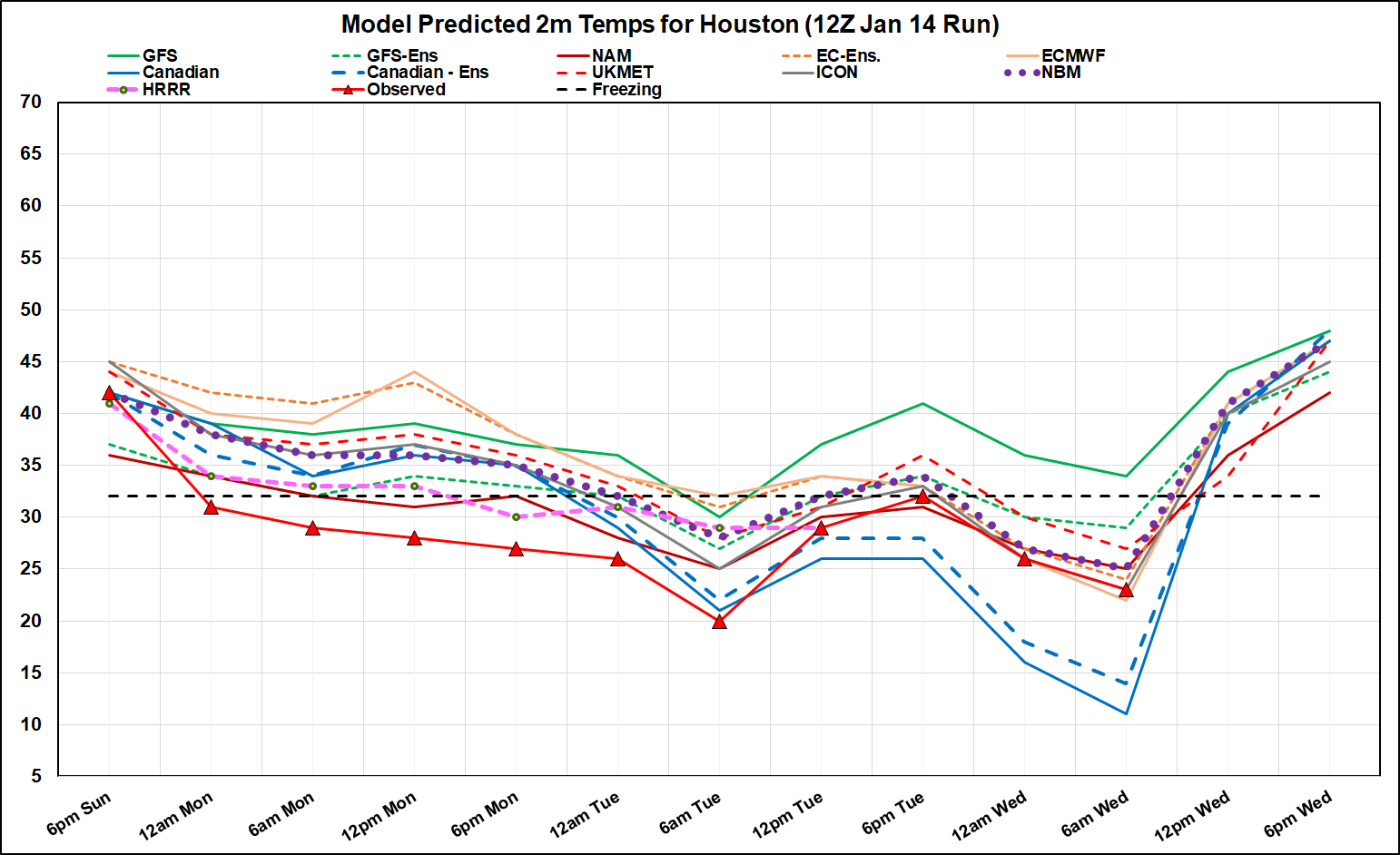
From WXMan 57 over at S2K...
Decided to look at the last model forecast before the front hit Sunday afternoon/evening. Black-bordered red triangles with red line are observed temps over central Houston (downtown). Every model performed badly, but HRRR and NAM were coldest, bringing the sub-freezing temps in MUCH earlier . GFS and Euro operationals were the worst for the first 48 hrs. NBM was generally about 5-7F too warm until yesterday afternoon.
Canadian hit Tuesday's low almost exactly from 48 hrs out. However, it was the worst for this morning's low. It has been forecasting 9F for this morning in every run after 12Z Sunday, even yesterday's run. Euro did best 72 hours out. NBM was still 2F too warm for this morning. GFS was terrible for the whole event.
This morning's low at my house was only 24. It was 20 yesterday morning.
http://wxman57.com/images/Verify.png
In other news, I'm getting a little concerned that we may have some flooding issues next week.
-
Stratton20
- Posts: 4248
- Joined: Tue Feb 09, 2021 11:35 pm
- Location: College Station, Texas
- Contact:
Only in texas do we go from icy roads to flooding withing a span of a week lol, texas weather is something else


As far as hysteria, I was referring more to social media and such in general (even some weather-based accounts that post more for clout), rather than actual meteorologists. Ever snce 2021, every cold outbreak headed for Texas generates hysteria, clicks, memes, schadenfreude, etc regarding ERCOT/energy grid. And it's all annoying (as much as I dislike conservatism/Texas state government in general).don wrote: ↑Wed Jan 17, 2024 12:22 pmWhat are you talking about? No one including the local media was ever forecasting a February 2021 repeat.The only disagreement we had was that the mesoscale models would end up more accurate than the globals when it comes to temps and precip. Which they were. You seem to want to disagree with us, just to disagree for some reason....
As for "cold overperformances", I actually never disagreed with the tendencies for mesoscales to be better than globals. All I mentioned was that "globals aren't always too warm", it's not some "hard fast" thing — look back earlier pages, and you can see what the GFS was spitting out for Feb 2021 prior to that event (hint: it actually was too cold, CMC style).
And, honestly? Even with "mesoscales" the story has been changing too. When this outbreak started getting into NAM range, people went on and on about how "NAM is great at detecting shallow airmasses". But then I check afterward, and now I'm seeing stories about "NAM too warm, CMC nailed it, etc". (CMC was just the "broken clock", honestly).
Safe to say that these airmasses have their own factors going on, regardless of models. Arctic air can plunge into Texas, but it can also scoot more eastward. Globals can indeed run quite warm, but they also can easily nail these events. Depends on which factors prevail (stength of upper-levels + leading low pressure system vs damming down the Rocky Mountains, etc).
Last edited by user:null on Wed Jan 17, 2024 12:56 pm, edited 1 time in total.
Due to its progressive nature, I’d expect those totals on the GFS to be further west. Which would be good because the Hill Country really needs the rain. You can probably shift those totals 100 miles west imo.
Yes, the globals can do a good job with arctic air. I don't think any of us ever disagreed with that. We were just stating that usually the mesoscale models will do a better job with temps and precip in the short term specifically with shallow air. I was never debating about the overall lows( I could care less to be honest LOL).user:null wrote: ↑Wed Jan 17, 2024 12:51 pmAs far as hysteria, I was referring more to social media and such in general (even some weather-based accounts that post more for clout), rather than actual meteorologists.don wrote: ↑Wed Jan 17, 2024 12:22 pmWhat are you talking about? No one including the local media was ever forecasting a February 2021 repeat.The only disagreement we had was that the mesoscale models would end up more accurate than the globals when it comes to temps and precip. Which they were. You seem to want to disagree with us, just to disagree for some reason....
Ever snce 2021, every cold outbreak headed for Texas generates hysteria, clicks, memes, schadenfreude, etc regarding ERCOT/energy grid. And it's all annoying (as much as I dislike conservatism/Texas state government in general).
As for "cold overperformances", I actually never disagreed with the tendencies for mesoscales to be better than globals. All I mentioned was that "globals aren't always too warm", it's not some "hard fast" thing — look back earlier pages, and you can see what the GFS was spitting out for Feb 2021.
And, honestly? Even with "mesoscales" the story has been changing too. When this outbreak started getting into NAM range, people went on and on about how "NAM is great at detecting shallow airmasses". But then I check afterward, and now I'm seeing stories about "NAM too warm, CMC nailed it, etc".
Safe to say that these airmasses have their own factors going on, regardless of models. Arctic air can plunge into Texas, but it can also scoot more eastward. Depending on which factors prevail, globals can and do nail these outbreaks.
My focus was if we would drop below freezing faster than what the global we're showing on Sunday as that would have big implications on whether we would have icing issues or just a cold rain. If meteorologists went with the global models last Friday/Saturday the general public would have been just expecting a cold rainy day on Monday. And would have been surprised with icy overpasses and flyovers. There would have been FAR more accidents than there were. The mesoscale models nailed the temps dropping faster allowing precip to become frozen.
And yes in general the mesoscale models did a better job than the global with temps with this event.I'm not sure what the debate is...
-
Stormlover2020
- Posts: 457
- Joined: Mon Jun 01, 2020 6:04 pm
- Contact:
I thought Nam and hrr did really well starting Saturday with the icy conditions, euro, cmc, gfs did flat out horrible
-
TexasBreeze
- Posts: 942
- Joined: Sun Sep 26, 2010 4:46 pm
- Location: NW Houston, TX
- Contact:
I know for sure the 18z gfs sure is wet!!!
Ha, yeah, no kidding! Over 16” in spots. Happy hour delivered the goods
-
Stratton20
- Posts: 4248
- Joined: Tue Feb 09, 2021 11:35 pm
- Location: College Station, Texas
- Contact:
lol the 18z GFS goes gung ho with rain fall totals
From HGX
Though headline
for next week won`t be the warming temperatures, but the rather wet
pattern that is being set up for the week.
A broad upper-level trough gets set up over the Desert Southwest
beginning late Sunday and will potentially stay there through the
majority of next week. This puts the western Gulf on the eastern
periphery of this trough. Like with most large troughs, there will
be shortwaves traversing it bringing localized increases of showers
and storms. Combine this with moist southeasterly flow at the
surface helping to fuel these showers and storms, we get the formula
for increased rainfall chances in SE Texas. It is too early to get
into specifics for how much, and exactly when, rainfall will occur
because of uncertainty with the location of the broad trough and
strength/timing of the shortwaves. But the chance for some drought-
busting rain is increasing. CPC gives the area a 70-80 percent
chance of above normal precipitation for our area in their 6 to 10
day outlook.
don wrote: ↑Wed Jan 17, 2024 1:26 pmYes, the globals can do a good job with arctic air. I don't think any of us ever disagreed with that. We were just stating that usually the mesoscale models will do a better job with temps and precip in the short term specifically with shallow air. I was never debating about the overall lows( I could care less to be honest LOL).user:null wrote: ↑Wed Jan 17, 2024 12:51 pmAs far as hysteria, I was referring more to social media and such in general (even some weather-based accounts that post more for clout), rather than actual meteorologists.don wrote: ↑Wed Jan 17, 2024 12:22 pmWhat are you talking about? No one including the local media was ever forecasting a February 2021 repeat.The only disagreement we had was that the mesoscale models would end up more accurate than the globals when it comes to temps and precip. Which they were. You seem to want to disagree with us, just to disagree for some reason....
Ever snce 2021, every cold outbreak headed for Texas generates hysteria, clicks, memes, schadenfreude, etc regarding ERCOT/energy grid. And it's all annoying (as much as I dislike conservatism/Texas state government in general).
As for "cold overperformances", I actually never disagreed with the tendencies for mesoscales to be better than globals. All I mentioned was that "globals aren't always too warm", it's not some "hard fast" thing — look back earlier pages, and you can see what the GFS was spitting out for Feb 2021.
And, honestly? Even with "mesoscales" the story has been changing too. When this outbreak started getting into NAM range, people went on and on about how "NAM is great at detecting shallow airmasses". But then I check afterward, and now I'm seeing stories about "NAM too warm, CMC nailed it, etc".
Safe to say that these airmasses have their own factors going on, regardless of models. Arctic air can plunge into Texas, but it can also scoot more eastward. Depending on which factors prevail, globals can and do nail these outbreaks.
My focus was if we would drop below freezing faster than what the global we're showing on Sunday as that would have big implications on whether we would have icing issues or just a cold rain. If meteorologists went with the global models last Friday/Saturday the general public would have been just expecting a cold rainy day on Monday. And would have been surprised with icy overpasses and flyovers. There would have been FAR more accidents than there were. The mesoscale models nailed the temps dropping faster allowing precip to become frozen.
And yes in general the mesoscale models did a better job than the global with temps with this event.I'm not sure what the debate is...
Yeah exactly. I think DoctorMu posted a NAM accumulation map and we commented that SETX history showed us the chances of frozen precipitation would be further to the south and east and indeed that's exactly what happened. If any points and lessons learned that should be emphasized are...
One: Predicting frozen precipitation chances, types, amounts, and location is extremely challenging down here in SETX and confidence will not be high until 12 to 18 hours before the event occurs. I know it's not what the public or anyone else wants to hear but unfortunately, that's just the reality of the situation.
Two: Always refer to past winter weather events that have affected SETX before pinpointing a forecast because though every event is different, you will notice certain patterns overall. In other words, don't ever strictly rely on computer models only whenever it comes to forecasting winter weather down here in our region.
There was never any "debate" in the formal sense of the term — my posts were actually just more of commentaries/inquiries based on sentiments that I've seen in the past from boards like this, storm2k, etc.don wrote: ↑Wed Jan 17, 2024 1:26 pmYes, the globals can do a good job with arctic air. I don't think any of us ever disagreed with that. We were just stating that usually the mesoscale models will do a better job with temps and precip in the short term specifically with shallow air. I was never debating about the overall lows( I could care less to be honest LOL).
My focus was if we would drop below freezing faster than what the global we're showing on Sunday as that would have big implications on whether we would have icing issues or just a cold rain. If meteorologists went with the global models last Friday/Saturday the general public would have been just expecting a cold rainy day on Monday. And would have been surprised with icy overpasses and flyovers. There would have been FAR more accidents than there were. The mesoscale models nailed the temps dropping faster allowing precip to become frozen.
And yes in general the mesoscale models did a better job than the global with temps with this event.I'm not sure what the debate is...
I pretty much agree with all of your post here. I just not a fan of dogmatic statements on these wx boards like "globals are always too warm" with arctic blasts — yes they whiff on events like this one, or the I-35 arborgeddon in late Jan/early Feb 2023, but they nail others like Feb 2021 and Dec 2022. I guess I'd prefer more discussion on why such discrepancies exist, instead of dogmatic statements against globals versus mesocales (or vice-versa).
And, again, even within mesoscales, the NAM, supposedly a great model at handling shallow airmasses, now apparently "ran too warm." Huh?
*couldn't.was never debating about the overall lows I could care less to be honest LOL).
Oh geez 
