
March 2024
.3" here in Cypress. Not even sure any pollen got washed away.
-
brazoriatx
- Posts: 329
- Joined: Tue Nov 08, 2011 12:09 pm
- Contact:
There had to of been a tornado here in angleton..trees down power lines down..overturnd 18wheeler..mulligans golf has there whole building tore apart..I doubt that was wind damage
- Attachments
-
-
brazoriatx
- Posts: 329
- Joined: Tue Nov 08, 2011 12:09 pm
- Contact:
My neighbor
- Attachments
-

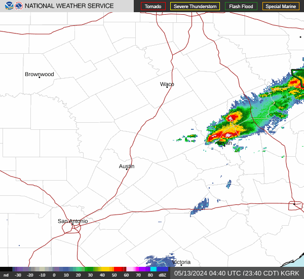
Storm reports coming in. Several reports of wind gust 60-70+ mph with reports of damage. With many reports of 1 inch size hail in the metro also. We can consider this our first severe weather event of this years tornado season.
Wind reports
- CapAaature.PNG (11.42 KiB) Viewed 388 times
Wind reports
Hail reports2140 77mph 2 SW Sugar Land Fort Bend TX
2145 60mph 4 SE Southside Place Harris TX WeatherFlow station. (HGX)
2218 UNK 3 S Needville Fort Bend TX Roof blown off a house. (HGX)
2257 62mph 1 SSW Highlands Harris TX (HGX)
2311 UNK 2 S Angleton Brazoria TX Large tree uprooted and knocked down wood fencing. (HGX)
2311 UNK 1 SSE Angleton Brazoria TX Power lines and trees down at Brazoria County Fairgrounds. Time estimated by radar. (HGX)
2315 70mph 3 NNW Angleton Brazoria TX Handheld anemometer measurement. (HGX)
2336 66mph 4 SSE Bailey's Prairie Brazoria TX (HGX)
2056 100 inch 5 ESE Richmond Fort Bend TX Quarter sized hail was reported. (HGX)
2100 100 inch 3 WSW Hallettsville Lavaca TX (EWX)
2106 100 inch First Colony Fort Bend TX (HGX)
2110 100 inch 2 SSW Sugar Land Fort Bend TX (HGX)
2130 100 inch 3 SE Southside Place Harris TX (HGX)
2145 150 inch 3 WNW South Houston Harris TX (HGX)
2158 100 inch 5 S Lumberton Hardin TX Photo received of 1 inch hail. Time estimated by radar. (LCH)
Angleton got messed up in places. The Sheriff's office is stating it wasn't a tornado, but thunderstorm winds would have had to be pretty nasty to do that kind of damage.
Surprise storm around 4 this morning with big hail that took nearly the exact same route south of me with the hail core. Raining very hard now though with light hail mixed in at my place. Someone got smacked hard south of me though. Doppler looks insane. I thought we were suppose to be quiet until Saturday afternoon.


Last edited by Cromagnum on Sat Mar 16, 2024 4:56 am, edited 1 time in total.
A few more nasty cells behind this one too.

Needville got absolutely smoked by that hailstorm about an hour before it blew south of me.


Wow at some of those pictures and radar. The front location outperformed the models and broke through the cap resulting in violent storms along a line in the Houston area.
It looks like more incoming for you all.
Our rainfall still stands at 0.00 inches.
Hopefully, this evening we'll see some rain, although there's a chanced at some light rain as the MCV passes south of us.
It looks like more incoming for you all.
Our rainfall still stands at 0.00 inches.
Hopefully, this evening we'll see some rain, although there's a chanced at some light rain as the MCV passes south of us.
The mesos have really struggled with the location of yesterday and today's rain. RGEM looks like potentially the most accurate for today.


-
Stratton20
- Posts: 4248
- Joined: Tue Feb 09, 2021 11:35 pm
- Location: College Station, Texas
- Contact:
Looks like the storms on radar to my south are weakening and falling apart, will see if any redevelopment occurs later this afternoon/ evening
The next batch of widespread rain will be late tonight/tomorrow morning.  Can't rule out completely thunderstorms forming as early as this evening though.
 Can't rule out completely thunderstorms forming as early as this evening though.
87°F in Victoria....
Tomorrow may be a washout.
I’m not sure why models and Mets are having so much trouble pegging down timing and rain/no rain lately. It seems that either the whole event is a bust or the timing is way off. I know it’s not an exact science, but it just seems more off than normal the past couple years. It’s probably just me in my feels hoping for today’s gully washer. I realize it may come tomorrow, but I don’t trust it much anymore.
Its always been that way, especially when we're dealing with the subtropical jet.Theirs not a lot of data coming from Mexico so the models have always had a hard time with pinpointing timing and strength of disturbances coming out of Mexico.The mesoscale models are your best friend.And when you see most of them in agreement just like yesterday, you can have good confidence in the rain being here tonight/tomorrow.I only really post here when i feel there's good data to support a decent event.Pas_Bon wrote: ↑Sat Mar 16, 2024 3:32 pm I’m not sure why models and Mets are having so much trouble pegging down timing and rain/no rain lately. It seems that either the whole event is a bust or the timing is way off. I know it’s not an exact science, but it just seems more off than normal the past couple years. It’s probably just me in my feels hoping for today’s gully washer. I realize it may come tomorrow, but I don’t trust it much anymore.
BTW looking at the severe weather reports locally I feel the SPC should have had us under an enhanced risk yesterday,instead of it being placed over south Texas where hardly any severe weather reports transpired.
- Screenshot 2024-03-16 at 15-26-52 Storm Prediction Center Yesterday's Storm Reports(1).png (16.46 KiB) Viewed 193 times
- Screenshot 2024-03-16 at 15-28-54 Storm Prediction Center Mar 15 2024 2000 UTC Day 1 Convective Outlook.png (11.67 KiB) Viewed 191 times
-
MontgomeryCoWx

- Posts: 2356
- Joined: Wed Dec 14, 2011 4:31 pm
- Location: Weimar, TX
- Contact:
It feels like swamp *** in Weimar at the moment. Atmosphere feels unstable. Late afternoon into overnight could get frisky.
Team #NeverSummer
Absolutely nothing. The next 6 hours look bleak. Maybe tonight.
We are just on the warm side of the front now, so you'd think the heat would trigger something...however, there's some worked over dry air ready to block any development short term. The blow-ups are well NE.
