April 2024
It is now 90 degrees at the casa.
88°F high here, 86°F at the airport. But at least it was dry.

Better change flight plans if you want to actually see the eclipse.
It’s starting to look like a vast majority of the month of April will be a wet one for us here in the Houston metro area. I’m fine with this.
-
Stratton20
- Posts: 4251
- Joined: Tue Feb 09, 2021 11:35 pm
- Location: College Station, Texas
- Contact:
Good keep it north
The bust/reverse bust for Eclipse watching.
From the SA/Austin NWS
LONG TERM...
(Sunday night through Friday)
Issued at 233 AM CDT Sat Apr 6 2024
Winds will have shifted back to SE across all areas by 00Z Sunday and
the moisture pooling from the washed out front over the Coastal
Prairies will push aggressively back inland in response to another
approaching upper low. At daybreak, only the Pandale and Langtry
areas are expected to remain out of the low cloud deck, and mixing
out of the low clouds could push back into the DRT area, but not much
more. This means solar eclipse watcher will have to compete with not
only a near widespread milky layer of cirrostratus but also a near
continuous deck of low cloud cover over almost all of South Central
TX. There is one potential hope for clearing, and that is from the
sharp gradient of deeper Gulf moisture advecting north and possibly
generating some deep convection. Should thunderstorms develop by this
time, there`s a good chance a few downdrafts could clear out the sky
briefly, at least at the lower levels. If this happens it may not
last long before the low levels saturate again.
The clouds will not be the only challenge facing the mobile solar
eclipse seekers. The latest SPC D3 outlook highlights an elongated
hodograph/steep lapse rate threat to suggest some large hail
potential should one get too close to the thunderstorms. Based on the
last few runs of deterministic QPF locations, it appears some of the
best forcing will come with the northward moving gradient of higher
Pwat values, which means some of the strong storms might actually
occur in the midday hours. The risk categories have us fully covered
by the 1 of 5, and the 2 of 5 covers the NErn 2/3 of the area. Storm
motions should not be an issue for heavy rain concerns, at least not
initially. After the brief swell of pooled higher PWat values shift
NE toward the Ark-la-tex, the coverage of deeper convection should
trend down and more shallow convection and lighter rates should be
most common.
Well the northern half of the viewing area looks to get a whole lot more than the southern half.
Day 4-8 Convective Outlook
NWS Storm Prediction Center Norman OK
0359 AM CDT Sat Apr 06 2024
Valid 091200Z - 141200Z
...DISCUSSION...
An active severe weather pattern should persist through mid-week
before diminishing towards next weekend. Primary feature of interest
will be a southern-stream shortwave trough near the Southwest/Mexico
border area at 12Z Tuesday. Non-GFS/GEFS guidance suggest this wave
should eject east and amplify as it approaches the Lower MS Valley,
before pivoting northeast ahead of a northern-stream shortwave
trough digging towards the Upper Midwest. As this likely occurs,
extensive convection is expected across the Gulf Coast region.
Initially steep mid-level lapse rates and fast mid-level flow will
support a broad severe weather area for D4/Tuesday across much of
central/east TX and LA. Although mid-level lapse rates should be
weaker on D5/Wednesday, the amplifying trough and resultant
deepening of the surface cyclone, in conjunction with rich
boundary-layer moisture, will support a continued severe threat area
focused on the Sabine and Lower MS Valleys.
The only real chance for eclipse viewing from Waco south is a line of storms that temporarily cleans up the mess.


The SPC has a large hatched area on the Day 3 outlook. They also mention that an upgrade to the risk area may be needed...
.Day 3 Convective Outlook
NWS Storm Prediction Center Norman OK
0230 AM CDT Sun Apr 07 2024
Valid 091200Z - 101200Z
...THERE IS A SLIGHT RISK OF SEVERE THUNDERSTORMS FROM WEST TX TO
THE LOWER MS VALLEY...
...SUMMARY...
Scattered severe thunderstorms are probable on Tuesday across most
of Texas to the Red and Lower Mississippi River Valleys. A few
tornadoes, significant large hail, and damaging winds are possible.
...Synopsis...
A shortwave trough centered near the AZ/NM/northwest Mexico border
area at 12Z Tuesday will likely move gradually eastward into west TX
by early Wednesday. Two separate mid-level speed maxes, one curling
through the base of the trough and another farther east closer to
the northwest Gulf Coast will gradually translate eastward. Primary
surface cyclone should become established over the Lower Rio Grande
Valley beneath the eastern jet, and eventually drift along a portion
of the TX Gulf Coast.
...TX/LA vicinity...
Several rounds of deep convection are expected across a large
portion of TX towards the Ark-La-Tex and Lower MS Valley vicinity
during the period. Greater severe weather probabilities may be
needed in later outlooks as mesoscale convective details become more
clear. For now, have highlighted a broad cat 2-SLGT risk with an
embedded significant severe area.
Overall convective evolution appears to be messy. Primary convective
coverage during the day will likely be tied to the persistent
low-level warm theta-e advection regime, with regenerative periods
of convection continuing through the period. Upper-level winds are
progged to be weaker relative to D2-Monday, suggesting that
cluster/MCS modes will likely dominate. Nevertheless, a feed of
steep mid-level lapse rates will be maintained in convectively
undisturbed areas and strong deep-layer shear will persist for
embedded supercells. Favorable low-level shear should largely remain
focused across the northwest Gulf into the Ark-La-Miss. With signals
for robust surface heating in parts of south-southeast TX in the
afternoon, the greatest tornado potential may exist into
east-southeast TX and far western LA on Tuesday evening.
Farther west, convection tied closer to the mid-level shortwave
trough and surface trough/dryline should redevelop Tuesday afternoon
in west TX. This activity should persist and/or separately develop
into central TX Tuesday night. A mix of significant large hail and
severe wind gusts should be the primary hazards within this regime
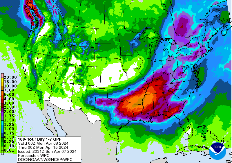
Weird how the CPC has a bullseye on S TX but the models have it over NE TX, AR, and LA.
The CPC map is referring to next weekend and beyond,not this weeks storm system.( it starts on April 13th)
Most of the rain for SE Texas will come with the MCS Tuesday overnight/Wednesday morning.Especially for areas north of I-10.
Yeah, I know. But even a week ago they had the darker greens over S TX, which isn’t going to verify.don wrote: ↑Sun Apr 07, 2024 4:49 pmThe CPC map is referring to next weekend and beyond,not this weeks storm system.( it starts on April 13th)
Most of the rain for SE Texas will come with the MCS Tuesday overnight/Wednesday morning.Especially for areas north of I-10.
rgem_mslp_pcpn_frzn_scus_73.png
ecmwf_mslp_pcpn_scus_23.png
ecmwf_mslp_pcpn_scus_24.png
Doesn’t look like much south of I-10:


-
Stratton20
- Posts: 4251
- Joined: Tue Feb 09, 2021 11:35 pm
- Location: College Station, Texas
- Contact:
Good, let it keep trending north
I am not liking Monday's weather.
Clouds have Eclipsed the viewing party. Today or yesterday or the day before or the day before would have been good.

NWS has an 80% chance of rain here tomorrow - they've been steadily going up.
Just watched KPRC-2 and they only have a 30%. The TV models don't show much until Tuesday - all north of here tomorrow. Interesting...
Just watched KPRC-2 and they only have a 30%. The TV models don't show much until Tuesday - all north of here tomorrow. Interesting...
-
- Information
-
Who is online
Users browsing this forum: Ahrefs [Bot], Bing [Bot], TexasBreeze and 27 guests
