

The transition from La Nina to El Nino in June 2023 really shut down rain in CLL and turned this place into a blast furnace. Even the crawfish suffered terribly.
Up here soggy conditions in the Spring could bode well temperature-wise for the summer. We'll see. We will have a greater chance of tropical action for sure.
May 2024
One things for sure, I’m not expecting this summer to be anywhere near as hot and dry as last summer.DoctorMu wrote: ↑Mon May 06, 2024 10:03 pm The transition from La Nina to El Nino in June 2023 really shut down rain in CLL and turned this place into a blast furnace. Even the crawfish suffered terribly.
Up here soggy conditions in the Spring could bode well temperature-wise for the summer. We'll see. We will have a greater chance of tropical action for sure.
-
Stratton20
- Posts: 4299
- Joined: Tue Feb 09, 2021 11:35 pm
- Location: College Station, Texas
- Contact:
In fact im not seeing much signs of a death ridge pattern this summer, that could be both a blessing and a curse, the positive being I do not expect an absolute blast torch of a summer, I expect more daily opportunities for scattered sea breeze activity, the downside, with the absence of a DR, that leaves texas wide open to potentially getting hit by some sort of tropical system
The Joplin-Carthage area of MO and OKC getting slammed now.
Bartlesville got absolutely slammed. I don't know how there aren't more deaths with social media fools standing out there trying to film these things in the dark and rain.
https://youtu.be/piUoRxrSmrQ?si=0T3J6U-qq8ZZOWNS
https://youtu.be/piUoRxrSmrQ?si=0T3J6U-qq8ZZOWNS
Dewpoint of 76°F. Nasty!
We should have DPs in the upper 50s in a couple of days - Thursday evening with a real live FROPA.
We should have DPs in the upper 50s in a couple of days - Thursday evening with a real live FROPA.
FXUS64 KHGX 072321
AFDHGX
Area Forecast Discussion
National Weather Service Houston/Galveston TX
621 PM CDT Tue May 7 2024
...New AVIATION...
.SHORT TERM...
(This evening through Wednesday Night)
Issued at 340 PM CDT Tue May 7 2024
A mostly tranquil period is expected through midweek.
For tonight, low overcast skies will redevelop during the night and
early morning hours. South to southeasterly winds will be between 5
and 10 mph tonight. It will feel rather muggy by early Wednesday
morning with lows staying in the low to mid 70s and a dewpoint
spread of only one or two degrees. Some locations could also see
areas of patchy fog, mainly for locations where winds are around 5
mph or lower. Fog, if any, is expected to burn off shortly after
sunrise but low cloud decks could take a little longer to lift and
scatter out.
Quasi zonal flow aloft along with a fairly good cap will result in
mostly dry conditions over Southeast Texas on Wednesday. However,
there is a chance that some of the storms developing over the
central and east central portions of Texas will move into the Piney
Woods region sometime during the late afternoon to early night
hours. Some of these storms could be strong to severe with damaging
winds and hail being the greatest hazards. Elsewhere, capping is
expected to suppress activity; thus, little to no chances of rainfall
is forecast. It will be breezy during the day with south southeaster
winds around 10 to 15 mph and higher gusts on occasion. The highs
will be a degree or two warmer, likely to be in the upper 80s to low
90s areawide. Some moisture convergence may occur during the day,
which may result in dewpoints in the mid 70s. This would allow for
heat indices in the upper 90s to low 100s for much of Southeast
Texas. Given that we haven`t had these indices in a while now, make
sure to be prepared for the heat and take the necessary precautions
to avoid heat stress and fatigue if you plan to spend time or work
outdoors.
Conditions will remain warm and muggy Wednesday night into early
Thursday morning with lows once again in the low to mid 70s.
24
&&
.LONG TERM...
(Thursday through next Monday)
Issued at 340 PM CDT Tue May 7 2024
Thursday will start out with a cold front situated between Dallas
and College Station, and a dry line across western portion of the
Hill Country. PW`s between 1.7-1.9" will be pooling south and
east of those features. H85 temps look to be between 20-24C and H7
temps 10-14C. Looking for a surface low to eventually form near
the intersection of the front/dryline then trek eastward across or
near the area during the afternoon and evening hours. Atmosphere
looks conditionally quite unstable with high CAPEs and low LI`s,
but the million dollar question is if significant llvl capping
will be able to erode enough, or be overcome, to tap into that
instability for shra/tstm development. Some of the global
solutions seem to think so...mainly across the northern 1/3-1/2 of
the CWA. If it does break, some strong-severe cells are possible
during the afternoon and evening hours and agree with SPC`s
conditional DAY 3 slight risk area. Hail & strong winds would be
the primary threats. Hires solutions will be coming into view
later tonight & tomorrow which should hopefully aid in forecast
confidence one way or the other.
Once the surface low passes to the east, high pressure will build
southward from the Rockies and Plains and push the front through
the area and offshore Thursday night. Drier and cooler airmass
will then filter into the region late Thursday night into
Saturday.
As high pressure slides off to the east Sunday, Gulf moisture will
flow back into the region. Mid and upper zonal flow looks somewhat
messy Sunday & Monday and most global deterministic solutions depict
better precip chances than NBM during some parts of this time period.
Nudged NBM POPs up just a touch for now, but suspect one of those days
will need some continued upward adjustments as time progresses. 47
Sunday and Monday are trending wetter. Ridiculously big difference from the Euro and GFS. CMC is closer to the Euro.
-
Stratton20
- Posts: 4299
- Joined: Tue Feb 09, 2021 11:35 pm
- Location: College Station, Texas
- Contact:
GFS has trended wetter, but confines the heaviest rain to north and east texas
Current Euro is in congruence.Stratton20 wrote: ↑Tue May 07, 2024 11:37 pm GFS has trended wetter, but confines the heaviest rain to north and east texas

DoctorMu wrote: ↑Tue May 07, 2024 11:57 pmCurrent Euro is in congruence.Stratton20 wrote: ↑Tue May 07, 2024 11:37 pm GFS has trended wetter, but confines the heaviest rain to north and east texas
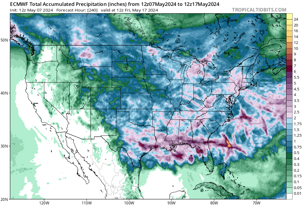

The wet pattern will return this weekend into next week, rainfall amounts and locations are subject to change of course. (12Z GFS VS 12Z EURO)
- Screenshot 2024-05-08 at 14-29-26 Models GFS - Pivotal Weather.png (1.01 MiB) Viewed 623 times
- Screenshot 2024-05-08 at 14-29-42 Models ECMWF - Pivotal Weather.png (1.15 MiB) Viewed 623 times


The forecast models are all over the place in rain amount and where it will happen. I have seen them get amount correct, but not the location.
Trends have been wetter and warmer - I was hoping for 2-3 days of cooler weather.
It looks like FROPA goes retrograde during the weekend undercutting our high 70s, lows in the upper 50s and sunnier weather.
DP of 75°F, 76°F for the 3rd day in a row. Blah!
Oooph. After all that rain, the mosquito population has absolutely exploded. Even my dogs aren't so eager to go out.
We only got 1/4 of an inch the whole week and no standing water anywhere and mosquitoes are terrible. I can only imagine for the flooded areas.
Muggiest day of the year out there so far in my opinion.
12Z global models (GFS,EURO,CANADIAN)
- Screenshot 2024-05-09 at 14-49-10 Models GFS - Pivotal Weather.png (1.01 MiB) Viewed 194 times
- Screenshot 2024-05-09 at 14-49-03 Models ECMWF - Pivotal Weather.png (1.15 MiB) Viewed 194 times
- Screenshot 2024-05-09 at 14-48-52 Models GDPS - Pivotal Weather.png (1.01 MiB) Viewed 194 times
The WPC once again has most of the rain north of I-10.