
Although this Summer has been so much more pleasant than recent iterations, I am beyond ready to put a bow on this B*^%+ and settle in for Fall.
The last couple weeks in League City have seen 95°+ temps and nary a rain drop in sight, so while a lot of the HOU metro has gotten drenched, we were Sahara Lite over here.
August 2025

Team Fall for sure.Pas_Bon wrote: ↑Wed Aug 20, 2025 8:43 pm Although this Summer has been so much more pleasant than recent iterations, I am beyond ready to put a bow on this B*^%+ and settle in for Fall.
The last couple weeks in League City have seen 95°+ temps and nary a rain drop in sight, so while a lot of the HOU metro has gotten drenched, we were Sahara Lite over here.
LFG!!
-
tireman4

- Global Moderator

- Posts: 6439
- Joined: Wed Feb 03, 2010 9:24 pm
- Location: Humble, Texas
- Contact:
150
FXUS64 KHGX 211115
AFDHGX
Area Forecast Discussion
National Weather Service Houston/Galveston TX
615 AM CDT Thu Aug 21 2025
...New AVIATION...
.KEY MESSAGES...
Issued at 1134 AM CDT Wed Aug 20 2025
- Increase in shower/storm coverage today through Friday with
locally heavy rainfall possible.
- Rain chances lower over the weekend, but should rise again next
week as another weak boundary approaches the area.
&&
.DISCUSSION...
Issued at 1214 AM CDT Thu Aug 21 2025
Today and Friday are still poised to see the greatest rain chances
in the forecast in part from a weak boundary moving into the
vicinity and stalling out along the coast. Pooling moisture, the
influx of additional lift provided from the boundary and shortwave
impulses moving over the areas should still support greater coverage
of showers showers/thunderstorms throughout this time frame. CAMs
still seem somewhat sparse both today and Friday, though seabreeze
and mesoscale boundary interactions could yield greater coverage
than currently depicted. Even with questionable reliability with the
CAMs as of recent, by in large they`ve trended upwards with respect
to convection for today. The environment is still conducive for
storms, featuring high precipitation efficiency that could result in
some strong downpours and possibly locally heavy rainfall at times.
WPC currently has SE Texas under a Marginal (level 1/4) Risk of
Excessive rainfall for today and Friday. Areas along the coast will
generally have the greatest chances of seeing localized heavy rains
during this period of the forecast.
Ridging is still poised to strengthen over the Desert Southwest this
weekend, reducing PoPs and pulling up temperatures. Though, daily
chances for showers/storms should continue into next week,
especially as a broad upper level low/trough over the Great
Lakes/Quebec/Ontario is poised to push another frontal boundary &
round of shortwaves towards our area early next week, around the
Tuesday/Wednesday time frame. Even as we trade heat for rain, the
broad picture of hot weather with daily storms still holds for the
foreseeable future.
03
&&
.AVIATION...
(12Z TAF Issuance)
Issued at 615 AM CDT Thu Aug 21 2025
With a very diffuse frontal boundary and plenty of moisture lingering
in the area, I`d anticipate similar wx conditions to what we saw
yesterday. Though isolated precip remains a possibility earlier,
suspect we`ll see another round of scattered storms develop later this
afternoon with daytime heating. Seabreeze/baybreeze will probably
come into play near the metro airports late in the day/evening so
will need to keep a watchful eye for any potential boundary
collisions with any incoming cells from the north that would
briefly enhance storm strength (winds/rain rates). Too localized
to pinpoint whether this would impact any specific Houston area
terminal at this point or not, but have maintained tempos til 0z
and prob30s into the mid evening hours for now. Outside of
convective activity, VFR conditions and light winds will prevail.
47
&&
.MARINE...
Issued at 1214 AM CDT Thu Aug 21 2025
Conditions will be fairly calm with 1-3 ft seas and seabreeze-
landbreeze driven winds around 5-10 knots (offshore/northwesterly
early in the morning, then onshore/southeasterly in the afternoon).
Isolated to scattered showers and storms will be a daily
possibility, primarily during the daytime hours. Coverage of
showers/storms should be greatest today and Friday as a weak
boundary pushes into the area. Rain chances later decrease over the
weekend. Locally higher winds and seas are expected near any
thunderstorms that develop.
03
&&
.PRELIMINARY POINT TEMPS/POPS...
College Station (CLL) 93 74 91 73 / 60 30 50 10
Houston (IAH) 95 76 91 76 / 60 50 70 30
Galveston (GLS) 92 80 90 81 / 50 60 80 50
&&
.HGX WATCHES/WARNINGS/ADVISORIES...
TX...None.
GM...None.
&&
$$
DISCUSSION...03
AVIATION...JM
MARINE...03

FROPA next Wednesday could bring highs below 90, then low 90s afterward. We have a weak boundary today and tomorrow that could trigger showers.
We will be in play in CLL. The models are vacillating on how far the front reaches before stalling.
For now...it appears we're in the massive donut hole.
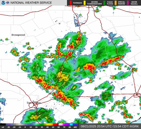
For now...it appears we're in the massive donut hole.
- mcd0965.gif (159.13 KiB) Viewed 114 times
Mesoscale Precipitation Discussion 0965
NWS Weather Prediction Center College Park MD
210 PM EDT Thu Aug 21 2025
Areas affected...portions of central through southeast Texas and
southwestern Louisiana
Concerning...Heavy rainfall...Flash flooding possible
Valid 211809Z - 220009Z
Summary...Scattered to numerous thunderstorm activity will pose an
isolated flash flood risk through 00Z/7p CDT this evening.
Discussion...Strong insolation/destabilization and the presence of
several meso-to-synoptic surface boundaries across the discussion
area has resulted in an uptick in coverage of thunderstorms over
the past half hour. The storms are in a very moist/buoyant
airmass characterized by 2+ inch PW values and 1000-2000 J/kg
MLCAPE values, favoring the eventual development of heavy rainfall
rates as storms mature. Additionally, storms are in a very weakly
sheared environment, with minimal steering flow aloft supporting
slow/erratic cell movement. Areas of 2 inch/hr rain rates are
expected at times through the afternoon hours, which poses an
isolated flash flood threat.
FFG thresholds are generally in the 2-3 inch/hr range (locally
lower near urban areas near Austin/San Antonio and Houston. These
thresholds and the pulse-type nature of the convection suggests
that any flash flood threat will be relatively isolated and
focused on urban and sensitive/low-lying areas. The bulk of the
threat should be diurnally driven and exhibit a slow southward
propagation toward coastal areas through 00Z/7p CDT.
Cook
ATTN...WFO...CRP...EWX...FWD...HGX...LCH...SHV...
ATTN...RFC...FWR...ORN...NWC...
LAT...LON 31719608 31489428 31329243 30079263 29369463
27699832 27719951 28070008 28930004 30049910
30999761
-
Stratton20
- Posts: 5489
- Joined: Tue Feb 09, 2021 11:35 pm
- Location: College Station, Texas
- Contact:
Oh look, another day with a high rain chance, and another bust, who could have seen that one coming

The donut hole is teasing us and pretending to close...
Preparing for an Outflow and collapse at the doorstep in 3...2...1...
Preparing for an Outflow and collapse at the doorstep in 3...2...1...
Welp. On cue - there's the outflow. We'll see if the semi-broken line can hold together.
- Attachments
-
- Screenshot 2025-08-21 at 4.02.11 PM.jpeg (500 KiB) Viewed 70 times
Still in a new, smaller donut. Hoping for a backbuilding miracle.
Yup, same here.Stratton20 wrote: ↑Thu Aug 21, 2025 3:31 pm Oh look, another day with a high rain chance, and another bust, who could have seen that one coming
Still in the donut and the energy is hopping over us, now riding on the outflow. So. Much. Fail. 

We remained in the donut, and there's a dry slot exit waiting for us. Lucy meets the Red Sea.
The mess is headed towards CoCo. That cell N of the Woodlands is probably going to slide west. NW Harris county could see some strong returns.
The mess is headed towards CoCo. That cell N of the Woodlands is probably going to slide west. NW Harris county could see some strong returns.