

Temperatures in the mid-thirties could indeed support sleet, but it won't stick.
It would be exciting nonetheless.
More cold air on the way next week!?
-
tireman4

- Global Moderator

- Posts: 4488
- Joined: Wed Feb 03, 2010 9:24 pm
- Location: Humble, Texas
- Contact:
Wxman57 ( or anyone else),
Could you do me a favor? The classic setup that gave Houston its snowfall December 5, 2009. Could you compare that and the current setup for next week? I guess you could use your meteograms...
Could you do me a favor? The classic setup that gave Houston its snowfall December 5, 2009. Could you compare that and the current setup for next week? I guess you could use your meteograms...
-
sleetstorm
- Posts: 651
- Joined: Thu Feb 04, 2010 12:33 pm
- Contact:
Oh, I already know that sleet will not stick to the ground knowing that it will be above the freezing mark, but if enough sleet does fall at a heavy enough rate and for a long enough time then it could force the temperature to drop even further, right?Cloud2ground wrote:Temperatures in the mid-thirties could indeed support sleet, but it won't stick.
It would be exciting nonetheless.
-
srainhoutx

- Site Admin

- Posts: 19616
- Joined: Tue Feb 02, 2010 2:32 pm
- Location: Maggie Valley, NC
- Contact:
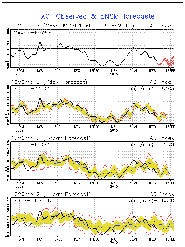
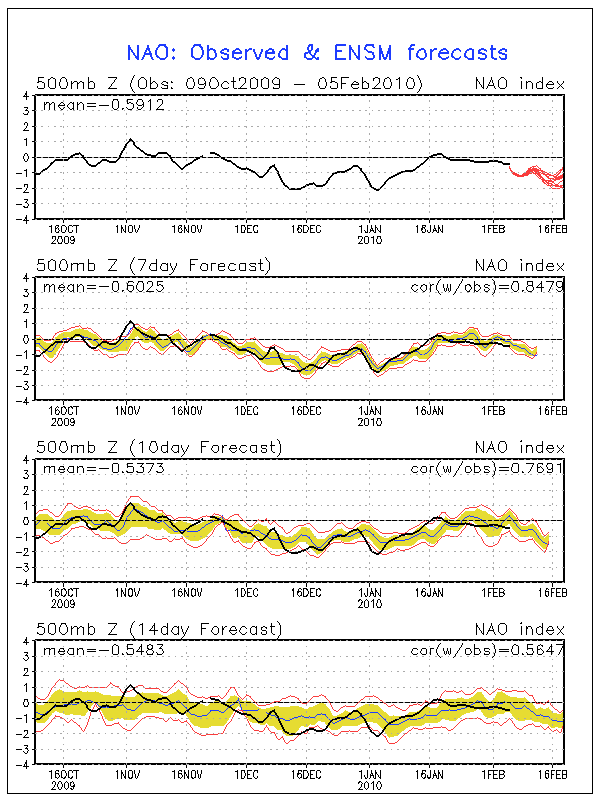
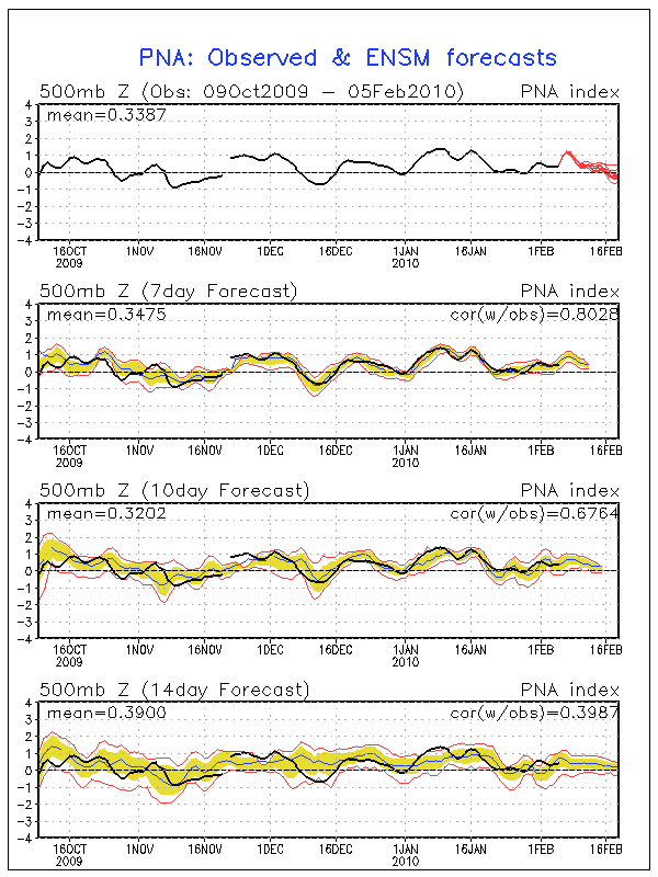
tireman4, there are some similarities. But cautiously we need to be mindful that no two patterns are exactly alike. This in fact was part of the reason I spent so much time on the old board laying a “foundation” regarding the –AO, -NAO, +PNA as well as the SSW/MMW events that are occurring. While I do not expect the cold to be as extreme as we saw in Late December/Early January, the current pattern in long range ensembles has been very difficult to discount. All in all we are heading toward a colder/stormier pattern as the month of February moves forward and some of the analogs via the CPC Super Ensembles are hard to ignore IMHO.
Carla/Alicia/Jerry(In The Eye)/Michelle/Charley/Ivan/Dennis/Katrina/Rita/Wilma/Humberto/Ike/Harvey
Member: National Weather Association
Facebook.com/Weather Infinity
Twitter @WeatherInfinity
Member: National Weather Association
Facebook.com/Weather Infinity
Twitter @WeatherInfinity
-
tireman4
- Global Moderator
- Posts: 4488
- Joined: Wed Feb 03, 2010 9:24 pm
- Location: Humble, Texas
- Contact:
srainhoutx wrote:tireman4, there are some similarities. But cautiously we need to be mindful that no two patterns are exactly alike. This in fact was part of the reason I spent so much time on the old board laying a “foundation” regarding the –AO, -NAO, +PNA as well as the SSW/MMW events that are occurring. While I do not expect the cold to be as extreme as we saw in Late December/Early January, the current pattern in long range ensembles has been very difficult to discount. All in all we are heading toward a colder/stormier pattern as the month of February moves forward and some of the analogs via the CPC Super Ensembles are hard to ignore IMHO.
Yes sir.
-
srainhoutx
- Site Admin
- Posts: 19616
- Joined: Tue Feb 02, 2010 2:32 pm
- Location: Maggie Valley, NC
- Contact:
Here are some images that hopefully will help...tireman4 wrote:srainhoutx wrote:tireman4, there are some similarities. But cautiously we need to be mindful that no two patterns are exactly alike. This in fact was part of the reason I spent so much time on the old board laying a “foundation” regarding the –AO, -NAO, +PNA as well as the SSW/MMW events that are occurring. While I do not expect the cold to be as extreme as we saw in Late December/Early January, the current pattern in long range ensembles has been very difficult to discount. All in all we are heading toward a colder/stormier pattern as the month of February moves forward and some of the analogs via the CPC Super Ensembles are hard to ignore IMHO.
Yes sir.
Carla/Alicia/Jerry(In The Eye)/Michelle/Charley/Ivan/Dennis/Katrina/Rita/Wilma/Humberto/Ike/Harvey
Member: National Weather Association
Facebook.com/Weather Infinity
Twitter @WeatherInfinity
Member: National Weather Association
Facebook.com/Weather Infinity
Twitter @WeatherInfinity
this is off topic but I am in the 290 beltway 8 area and - well yess - I am seeing the sun - really no kidding - bright sunshine for the last 10 minutes!!!!!!

Temple Terrace [Hillsborough Co, FL] emergency mngr reports TSTM WND DMG at 03:02 PM EST -- *** 7 inj *** a 50 by 50 foot tent collapsed at the florida state fair. winds were estimated at 60mph. 7 people were injured and transported to the hospital.
What happened to the winter discussion??? Getting off topic here. 
-
biggerbyte
- Posts: 1142
- Joined: Thu Feb 04, 2010 12:15 am
- Location: Porter, Texas. (Montgomery County)
- Contact:
Muhahahahaha


February is tornado season for Florida.Ed Mahmoud wrote:harpman wrote:What happened to the winter discussion??? Getting off topic here.
Tornadoes in February. Sounds like Florida Winter Weather to me.
-
srainhoutx
- Site Admin
- Posts: 19616
- Joined: Tue Feb 02, 2010 2:32 pm
- Location: Maggie Valley, NC
- Contact:
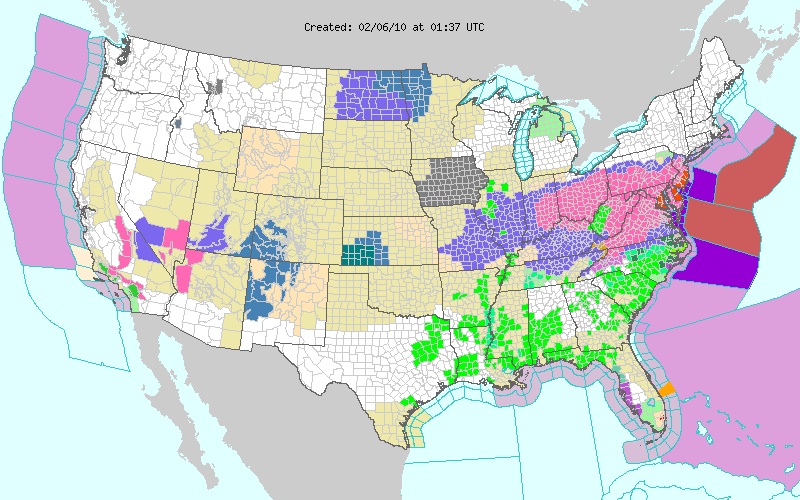
Notice the Hurricane Force winds off the Mid Atlantic on the right...perhaps the night crew will be busy...
Carla/Alicia/Jerry(In The Eye)/Michelle/Charley/Ivan/Dennis/Katrina/Rita/Wilma/Humberto/Ike/Harvey
Member: National Weather Association
Facebook.com/Weather Infinity
Twitter @WeatherInfinity
Member: National Weather Association
Facebook.com/Weather Infinity
Twitter @WeatherInfinity

that is one tight pressure gradient sheesh.....
Last edited by Paul on Fri Feb 05, 2010 9:35 pm, edited 1 time in total.
Not looking good for southeast Texas next week, as far as frozen precip goes, according to my trusty GFS forecast precipitation.
Looks good for Dallas and maybe points 80 to a 100 miles north of us.
Sorry Charley.
Looks good for Dallas and maybe points 80 to a 100 miles north of us.
Sorry Charley.
Cloud2ground wrote:Not looking good for southeast Texas next week, as far as frozen precip goes, according to my trusty GFS forecast precipitation.
Looks good for Dallas and maybe points 80 to a 100 miles north of us.
Sorry Charley.
yep, just normal to slightly below normal temps....slowly we warm up. IMO, winter has sung its last song....
-
srainhoutx
- Site Admin
- Posts: 19616
- Joined: Tue Feb 02, 2010 2:32 pm
- Location: Maggie Valley, NC
- Contact:
Thundersnow in the Mid Atlantic... N Atlantic Storm was showing low 900mb readings... RECON is enroute I believe.Paul wrote:that is one tight pressure gradient sheesh.....
Carla/Alicia/Jerry(In The Eye)/Michelle/Charley/Ivan/Dennis/Katrina/Rita/Wilma/Humberto/Ike/Harvey
Member: National Weather Association
Facebook.com/Weather Infinity
Twitter @WeatherInfinity
Member: National Weather Association
Facebook.com/Weather Infinity
Twitter @WeatherInfinity

FWIW 0z GFS is slightly colder though not as cold as it was yesterday but colder and more moisture non the less.


-
sleetstorm
- Posts: 651
- Joined: Thu Feb 04, 2010 12:33 pm
- Contact:
It certainly is looking like a terrific sleet storm is going to end up transpiring here in southeast Texas sometime next week with moderate to feasilbly even heavy sleet. Would a rain snow mix be out of the question with highs in the mid or lower thirties, anyone  I am going to say no because if the temperature in the mid and upper parts of the atmosphere is able to support sleet then a rain snow mix would not be out of the question, either. What do you think?
Last edited by sleetstorm on Fri Feb 05, 2010 11:01 pm, edited 1 time in total.
-
weatherguy425
- Pro Met

- Posts: 830
- Joined: Wed Feb 03, 2010 7:45 pm
- Location: Atlanta, Georgia
- Contact:
sleetstorm, i certainly wouldnt say a "sleetstorm is highly possible", in fact recent modelshave trended even further away from something of that magnitude, things could change but right now it's a "nada".
Well GFS shows temps in the mid 30's (36-34F) so i guess there COULD be some sleet if those temps were to verify but for right now the trend of the models are not in are favor as far as those of us who want wintry precip but at the same time im not totally ready to dismiss it either we should have a better handle on the situation by Sunday..sleetstorm wrote:It certainly is looking like a terrific sleet storm is going to end up transpiring here in southeast Texas sometime next week with moderate to feasilbly even heavy sleet. Would a rain snow mix be out of the question with highs in the mid or lower thirties, anyone