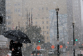
srainhoutx wrote:Light flurries in NW Harris County at this time.
As I look at the latest RUC sounding for your area, it shows a shallow sub-freezing layer (around 1000ft thick) at the surface and a 8000 ft thick layer of well above-freezing air (into the 40s) just above that surface layer. One would think snow would be impossible with such a sounding. Of course, that depends on if the RUC model sounding is accurate. Nearest RAOB stations are Corpus, Lake Charles, and Longview.
It's scary if the models can be so far off with a projected sounding just with their initialization.
That is one of the reasons I wanted to get that information out. Even as I type there are still spits of flurries flying, although light and sporadic.
Same going on here. Sounding is wrong if readings indicate atmosphere incapable of making snow.
srainhoutx wrote:
That is one of the reasons I wanted to get that information out. Even as I type there are still spits of flurries flying, although light and sporadic.
Could you actually tell they were snowflakes and now small drops of drizzle floating around? Did you let them land on your coat or a dark surface and observe the crystalline structure?
And last week the soundings were off in the other direction - they indicated snow but there was a warm layer aloft.
They are flurries. The freezing drizzle and mist was very evident early this morning and clearly liquid. It may well be small grapple nuclei in nature, but it is frozen and is not a sleet 'pellet'.
Carla/Alicia/Jerry(In The Eye)/Michelle/Charley/Ivan/Dennis/Katrina/Rita/Wilma/Humberto/Ike/Harvey
Member: National Weather Association
Facebook.com/Weather Infinity
Twitter @WeatherInfinity
srainhoutx wrote:
That is one of the reasons I wanted to get that information out. Even as I type there are still spits of flurries flying, although light and sporadic.
Could you actually tell they were snowflakes and now small drops of drizzle floating around? Did you let them land on your coat or a dark surface and observe the crystalline structure?
And last week the soundings were off in the other direction - they indicated snow but there was a warm layer aloft.
I did.
But you're in the frozen tundra of northern Montgomery County.
srainhoutx wrote:
That is one of the reasons I wanted to get that information out. Even as I type there are still spits of flurries flying, although light and sporadic.
Could you actually tell they were snowflakes and now small drops of drizzle floating around? Did you let them land on your coat or a dark surface and observe the crystalline structure?
And last week the soundings were off in the other direction - they indicated snow but there was a warm layer aloft.
They are flurries. The freezing drizzle and mist was very evident early this morning and clearly liquid. It may well be small graupel nuclei in nature, but it is frozen and is not a sleet 'pellet'.
So it's graupelly (to make up a word)? Little white clumps? That would be strange, too, as graupel forms when snow falls through a shallow warm layer, partially melts, then re-freezes.
wxman57 wrote:Light flurries in NW Harris County at this time.
As I look at the latest RUC sounding for your area, it shows a shallow sub-freezing layer (around 1000ft thick) at the surface and a 8000 ft thick layer of well above-freezing air (into the 40s) just above that surface layer. One would think snow would be impossible with such a sounding. Of course, that depends on if the RUC model sounding is accurate. Nearest RAOB stations are Corpus, Lake Charles, and Longview.
That is one of the reasons I wanted to get that information out. Even as I type there are still spits of flurries flying, although light and sporadic.
Same going on here. Sounding is wrong if readings indicate atmosphere incapable of making snow.[/quote]
I had snow and yes it was snow for about 2 minutes (heavy wet snow actually) in Richmond around 1145. Glaze on cars was bumpy and you could see IP mixed in. The soundings are the soundings, but this is what was actually happening. There have been a fairly decent number of light snow and flurry reports this afternoon.
Paul wrote:someone launch a balloon already,,,,sheeesh...
There is no sounding station and there will not be a sounding station. For the few times a year we have to deal with such issues the argument for a HGX sounding for winter P-type is weak...now if one were to suggest a sounding for spring capping intensity for severe weather events I would be more on board with that
I've been having flurries here on an off for about an hour here. It's not graupel. In my experience, graupel tends to fall more rapidly to the surface and not "float" all around the air like snow/flurries do.
The sounding has to be wrong. It's not surprising to me at all - we see it all the time. Remember back in December some of us saw sleet when it was almost 50 degrees outside. We all know what the soundings showed what we *should* have been seeing.