
93L Nearing The Gulf. Texas Bound?
-
srainhoutx

- Site Admin

- Posts: 19616
- Joined: Tue Feb 02, 2010 2:32 pm
- Location: Maggie Valley, NC
- Contact:
The 12Z HWRF suggests a TS S of Lafayette and then on into N MX. The GFDL never develops 93L.
- Attachments
-
Carla/Alicia/Jerry(In The Eye)/Michelle/Charley/Ivan/Dennis/Katrina/Rita/Wilma/Humberto/Ike/Harvey
Member: National Weather Association
Facebook.com/Weather Infinity
Twitter @WeatherInfinity
Member: National Weather Association
Facebook.com/Weather Infinity
Twitter @WeatherInfinity
a good portion already off the coast of FL - this sat loop takes a while to load
http://www.tropicalatlantic.com/satelli ... 28&lon=-82
http://www.tropicalatlantic.com/satelli ... 28&lon=-82
animated models http://flhurricane.com/sbanimator.php?year=2011&storm=1
-
desiredwxgd
- Posts: 125
- Joined: Wed Feb 03, 2010 6:30 pm
- Location: TX/LA/Southern New England
- Contact:
"Would be" Arlene" is moving fastunome wrote:animated models http://flhurricane.com/sbanimator.php?year=2011&storm=1
http://www.ssd.noaa.gov/goes/flt/t1/flash-vis.html
JMS
SR. ENSC.
SR. ENSC.
-
srainhoutx
- Site Admin
- Posts: 19616
- Joined: Tue Feb 02, 2010 2:32 pm
- Location: Maggie Valley, NC
- Contact:
18Z Model tracks...
Carla/Alicia/Jerry(In The Eye)/Michelle/Charley/Ivan/Dennis/Katrina/Rita/Wilma/Humberto/Ike/Harvey
Member: National Weather Association
Facebook.com/Weather Infinity
Twitter @WeatherInfinity
Member: National Weather Association
Facebook.com/Weather Infinity
Twitter @WeatherInfinity
-
srainhoutx
- Site Admin
- Posts: 19616
- Joined: Tue Feb 02, 2010 2:32 pm
- Location: Maggie Valley, NC
- Contact:
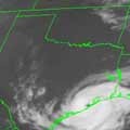
93L has almost completed the trek across Florida as thunderstorms begin to flare up once again...a lot of hail reports from Florida suggest there is still some cold core connection to this disturbance...
- Attachments
-
Carla/Alicia/Jerry(In The Eye)/Michelle/Charley/Ivan/Dennis/Katrina/Rita/Wilma/Humberto/Ike/Harvey
Member: National Weather Association
Facebook.com/Weather Infinity
Twitter @WeatherInfinity
Member: National Weather Association
Facebook.com/Weather Infinity
Twitter @WeatherInfinity
-
wxman57

- Global Moderator

- Posts: 2621
- Joined: Thu Feb 04, 2010 5:34 am
- Location: Southwest Houston (Westbury)
- Contact:
Note that the weak LLC was identified to be on the EAST coast of Florida, quite a distance from those squalls. But the LLC is VERY weak. Obs across Florida now indicate that the LLC is re-forming farther west, closer to the convection. Development chances remain low. Unfortunately, it may track too far to our south to give Houston much rain on Friday.

Is that high parked over us projected to move East even a bit.
HPC 7-day loop of pressures & fronts: http://www.hpc.ncep.noaa.gov/basicwx/day0-7loop.html
updated marine graphicast

if the storms stay a bit NW of the center, we may have some chance for precip ?

looping here:
http://rammb.cira.colostate.edu/product ... 011515.jpg
updated marine graphicast
if the storms stay a bit NW of the center, we may have some chance for precip ?
looping here:
http://rammb.cira.colostate.edu/product ... 011515.jpg
-
srainhoutx
- Site Admin
- Posts: 19616
- Joined: Tue Feb 02, 2010 2:32 pm
- Location: Maggie Valley, NC
- Contact:
00Z surface chart
- Attachments
-
Carla/Alicia/Jerry(In The Eye)/Michelle/Charley/Ivan/Dennis/Katrina/Rita/Wilma/Humberto/Ike/Harvey
Member: National Weather Association
Facebook.com/Weather Infinity
Twitter @WeatherInfinity
Member: National Weather Association
Facebook.com/Weather Infinity
Twitter @WeatherInfinity


Let's hope for some rain this weekend. 
-
srainhoutx
- Site Admin
- Posts: 19616
- Joined: Tue Feb 02, 2010 2:32 pm
- Location: Maggie Valley, NC
- Contact:
Down to 10% and rain chances for us are dwindling...~sigh~...
DISORGANIZED SHOWERS AND THUNDERSTORMS OVER THE FAR NORTHEASTERN
GULF OF MEXICO ARE ASSOCIATED WITH AN ELONGATED LOW PRESSURE AREA.
SIGNIFICANT DEVELOPMENT OF THIS SYSTEM IS UNLIKELY AS ENVIRONMENTAL
CONDITIONS ARE NOT PARTICULARLY CONDUCIVE OVER THE GULF OF MEXICO.
THERE IS A LOW CHANCE...10 PERCENT...OF THIS SYSTEM BECOMING A
TROPICAL CYCLONE DURING THE NEXT 48 HOURS AS IT MOVES
WEST-SOUTHWESTWARD AT 25 MPH.
Carla/Alicia/Jerry(In The Eye)/Michelle/Charley/Ivan/Dennis/Katrina/Rita/Wilma/Humberto/Ike/Harvey
Member: National Weather Association
Facebook.com/Weather Infinity
Twitter @WeatherInfinity
Member: National Weather Association
Facebook.com/Weather Infinity
Twitter @WeatherInfinity
-
sleetstorm
- Posts: 651
- Joined: Thu Feb 04, 2010 12:33 pm
- Contact:
So, conditions in the atmophere, specifically the troposphere, seemed to be conducive for good development, yet they are not ripe enough. The other thing that is working against that wave of low pressure is the speed at which it is traveling.
-
srainhoutx
- Site Admin
- Posts: 19616
- Joined: Tue Feb 02, 2010 2:32 pm
- Location: Maggie Valley, NC
- Contact:
A SURFACE TROUGH LOCATED OVER THE CENTRAL GULF OF MEXICO IS
PRODUCING AN AREA OF SHOWERS AND THUNDERSTORMS THAT EXTENDS SEVERAL
HUNDRED MILES SOUTH OF THE COAST OF LOUISIANA. ENVIRONMENTAL
CONDITIONS DO NOT APPEAR CONDUCIVE FOR DEVELOPMENT...AND THERE IS A
LOW CHANCE...NEAR 0 PERCENT...OF THIS SYSTEM BECOMING A TROPICAL
CYCLONE DURING THE NEXT 48 HOURS AS IT MOVES WEST-SOUTHWESTWARD AT
20 TO 25 MPH.
Carla/Alicia/Jerry(In The Eye)/Michelle/Charley/Ivan/Dennis/Katrina/Rita/Wilma/Humberto/Ike/Harvey
Member: National Weather Association
Facebook.com/Weather Infinity
Twitter @WeatherInfinity
Member: National Weather Association
Facebook.com/Weather Infinity
Twitter @WeatherInfinity
-
wxman57
- Global Moderator
- Posts: 2621
- Joined: Thu Feb 04, 2010 5:34 am
- Location: Southwest Houston (Westbury)
- Contact:
Big question is whether that blob of squalls north of the weak circulation near 25.5/88W will make it to southeast Texas or dissipate and re-fire farther south closer to the circulation. I'm not holding my breath.
-
srainhoutx
- Site Admin
- Posts: 19616
- Joined: Tue Feb 02, 2010 2:32 pm
- Location: Maggie Valley, NC
- Contact:
SMALL AREA OF LOW PRESSURE IS PRODUCING LIMITED SHOWER AND
THUNDERSTORM ACTIVITY SEVERAL HUNDRED MILES NORTH OF THE YUCATAN
PENINSULA. ALTHOUGH ENVIRONMENTAL CONDITIONS ARE NOT CONDUCIVE FOR
DEVELOPMENT...THE CIRCULATION ASSOCIATED WITH THE SYSTEM HAS BECOME
A LITTLE BETTER DEFINED TODAY. THERE IS STILL A LOW CHANCE...10
PERCENT...OF THIS SYSTEM BECOMING A TROPICAL CYCLONE DURING THE
NEXT 48 HOURS AS IT MOVES WEST-SOUTHWESTWARD AT 15 TO 20 MPH.
Carla/Alicia/Jerry(In The Eye)/Michelle/Charley/Ivan/Dennis/Katrina/Rita/Wilma/Humberto/Ike/Harvey
Member: National Weather Association
Facebook.com/Weather Infinity
Twitter @WeatherInfinity
Member: National Weather Association
Facebook.com/Weather Infinity
Twitter @WeatherInfinity
-
srainhoutx
- Site Admin
- Posts: 19616
- Joined: Tue Feb 02, 2010 2:32 pm
- Location: Maggie Valley, NC
- Contact:
A SMALL AREA OF LOW PRESSURE LOCATED OVER THE WESTERN GULF OF MEXICO
ABOUT 325 MILES EAST OF THE MEXICAN COAST IS PRODUCING LIMITED
SHOWER ACTIVITY. UPPER-LEVEL WINDS ARE NOT FAVORABLE FOR
DEVELOPMENT...AND THERE IS A LOW CHANCE... NEAR 0 PERCENT...OF THIS
SYSTEM BECOMING A TROPICAL CYCLONE DURING THE NEXT 48 HOURS AS IT
MOVES WESTWARD AT ABOUT 10 TO 15 MPH.
ABOUT 325 MILES EAST OF THE MEXICAN COAST IS PRODUCING LIMITED
SHOWER ACTIVITY. UPPER-LEVEL WINDS ARE NOT FAVORABLE FOR
DEVELOPMENT...AND THERE IS A LOW CHANCE... NEAR 0 PERCENT...OF THIS
SYSTEM BECOMING A TROPICAL CYCLONE DURING THE NEXT 48 HOURS AS IT
MOVES WESTWARD AT ABOUT 10 TO 15 MPH.
Carla/Alicia/Jerry(In The Eye)/Michelle/Charley/Ivan/Dennis/Katrina/Rita/Wilma/Humberto/Ike/Harvey
Member: National Weather Association
Facebook.com/Weather Infinity
Twitter @WeatherInfinity
Member: National Weather Association
Facebook.com/Weather Infinity
Twitter @WeatherInfinity
-
srainhoutx
- Site Admin
- Posts: 19616
- Joined: Tue Feb 02, 2010 2:32 pm
- Location: Maggie Valley, NC
- Contact:
Moving inland...Ed Mahmoud wrote:Cue Bones...
- Attachments
-
Carla/Alicia/Jerry(In The Eye)/Michelle/Charley/Ivan/Dennis/Katrina/Rita/Wilma/Humberto/Ike/Harvey
Member: National Weather Association
Facebook.com/Weather Infinity
Twitter @WeatherInfinity
Member: National Weather Association
Facebook.com/Weather Infinity
Twitter @WeatherInfinity