
Product: Air Force Vortex Message (URNT12 KNHC)
Transmitted: 29th day of the month at 16:05Z
Aircraft: Air Force Aircraft (Last 3 digits of the tail number are 308)
Storm Number & Year: 01L in 2011
Storm Name: Arlene (flight in the North Atlantic basin)
Mission Number: 2
Observation Number: 12
A. Time of Center Fix: 29th day of the month at 15:44:00Z
B. Center Fix Coordinates: 21°03'N 95°36'W (21.05N 95.6W)
B. Center Fix Location: 166 miles (267 km) to the ESE (119°) from Tampico, Tamaulipas, México.
C. Minimum Height at Standard Level: Not Available
D. Estimated (by SFMR or visually) Maximum Surface Wind: 47kts (~ 54.1mph)
E. Location of the Estimated Maximum Surface Wind: 54 nautical miles (62 statute miles) to the SW (231°) of center fix
F. Maximum Flight Level Wind Inbound: From 262° at 47kts (From the W at ~ 54.1mph)
G. Location of Maximum Flight Level Wind Inbound: 54 nautical miles (62 statute miles) to the SW (231°) of center fix
H. Minimum Sea Level Pressure: 1000mb (29.53 inHg)
I. Maximum Flight Level Temp & Pressure Altitude Outside Eye: 20°C (68°F) at a pressure alt. of 360m (1,181ft)
J. Maximum Flight Level Temp & Pressure Altitude Inside Eye: 24°C (75°F) at a pressure alt. of 364m (1,194ft)
K. Dewpoint Temp (collected at same location as temp inside eye): 24°C (75°F)
K. Sea Surface Temp (collected at same location as temp inside eye): Not Available
L. Eye Character: Not Available
M. Eye Shape: Not Available
N. Fix Determined By: Penetration, Wind, Pressure and Temperature
N. Fix Levels (sfc and flt lvl centers are within 5nm of each other): Surface and 1,500 feet
O. Navigation Fix Accuracy: 0.02 nautical miles
O. Meteorological Accuracy: 10 nautical miles
Remarks Section - Remarks That Were Decoded...
Maximum Flight Level Wind: 52kts (~ 59.8mph) in the southwest quadrant at 15:15:30Z
Remarks Section - Additional Remarks...
DIAMETER OF L/V CTR 20NM
Remnants of Arlene: Inland North of Tuxpan, MX
-
srainhoutx

- Site Admin

- Posts: 19616
- Joined: Tue Feb 02, 2010 2:32 pm
- Location: Maggie Valley, NC
- Contact:
Carla/Alicia/Jerry(In The Eye)/Michelle/Charley/Ivan/Dennis/Katrina/Rita/Wilma/Humberto/Ike/Harvey
Member: National Weather Association
Facebook.com/Weather Infinity
Twitter @WeatherInfinity
Member: National Weather Association
Facebook.com/Weather Infinity
Twitter @WeatherInfinity
-
desiredwxgd
- Posts: 125
- Joined: Wed Feb 03, 2010 6:30 pm
- Location: TX/LA/Southern New England
- Contact:
Looking Healthy--
- Attachments
-
- iuy.jpg (26.85 KiB) Viewed 4011 times
JMS
SR. ENSC.
SR. ENSC.
-
srainhoutx
- Site Admin
- Posts: 19616
- Joined: Tue Feb 02, 2010 2:32 pm
- Location: Maggie Valley, NC
- Contact:
12Z HWRF...
- Attachments
-
Carla/Alicia/Jerry(In The Eye)/Michelle/Charley/Ivan/Dennis/Katrina/Rita/Wilma/Humberto/Ike/Harvey
Member: National Weather Association
Facebook.com/Weather Infinity
Twitter @WeatherInfinity
Member: National Weather Association
Facebook.com/Weather Infinity
Twitter @WeatherInfinity


-
srainhoutx
- Site Admin
- Posts: 19616
- Joined: Tue Feb 02, 2010 2:32 pm
- Location: Maggie Valley, NC
- Contact:
The HWRF seems to always be poleward and too strong. 12Z GFDL...wxman57 wrote:HWRF looks way too far north. Closer to Tuxpan, not Tampico.
- Attachments
-
Carla/Alicia/Jerry(In The Eye)/Michelle/Charley/Ivan/Dennis/Katrina/Rita/Wilma/Humberto/Ike/Harvey
Member: National Weather Association
Facebook.com/Weather Infinity
Twitter @WeatherInfinity
Member: National Weather Association
Facebook.com/Weather Infinity
Twitter @WeatherInfinity
-
srainhoutx
- Site Admin
- Posts: 19616
- Joined: Tue Feb 02, 2010 2:32 pm
- Location: Maggie Valley, NC
- Contact:
Product: Air Force Vortex Message (URNT12 KNHC)
Transmitted: 29th day of the month at 21:25Z
Aircraft: Air Force Aircraft (Last 3 digits of the tail number are 309)
Storm Number & Year: 01L in 2011
Storm Name: Arlene (flight in the North Atlantic basin)
Mission Number: 3
Observation Number: 04
A. Time of Center Fix: 29th day of the month at 21:11:20Z
B. Center Fix Coordinates: 21°20'N 95°30'W (21.3333N 95.5W)
B. Center Fix Location: 163 miles (262 km) to the ESE (112°) from Tampico, Tamaulipas, México.
C. Minimum Height at Standard Level: Not Available
D. Estimated (by SFMR or visually) Maximum Surface Wind: 66kts (~ 76.0mph)
E. Location of the Estimated Maximum Surface Wind: 45 nautical miles (52 statute miles) to the NNE (17°) of center fix
F. Maximum Flight Level Wind Inbound: From 163° at 64kts (From the SSE at ~ 73.6mph)
G. Location of Maximum Flight Level Wind Inbound: 49 nautical miles (56 statute miles) to the NNE (21°) of center fix
H. Minimum Sea Level Pressure: 996mb (29.41 inHg) - Extrapolated
I. Maximum Flight Level Temp & Pressure Altitude Outside Eye: 22°C (72°F) at a pressure alt. of 399m (1,309ft)
J. Maximum Flight Level Temp & Pressure Altitude Inside Eye: 25°C (77°F) at a pressure alt. of 396m (1,299ft)
K. Dewpoint Temp (collected at same location as temp inside eye): 19°C (66°F)
K. Sea Surface Temp (collected at same location as temp inside eye): Not Available
L. Eye Character: Not Available
M. Eye Shape: Not Available
N. Fix Determined By: Penetration, Wind, Pressure and Temperature
N. Fix Levels (sfc and flt lvl centers are within 5nm of each other): Surface and 1,500 feet
O. Navigation Fix Accuracy: 0.02 nautical miles
O. Meteorological Accuracy: 5 nautical miles
Remarks Section - Remarks That Were Decoded...
Maximum Flight Level Wind: 64kts (~ 73.6mph) in the north quadrant at 20:26:50Z
Sea Level Pressure Extrapolation From: Below 1,500 feet
Remarks Section - Additional Remarks...
MAX FL AND SFC WINDS BOTH CONVECTION INDUCED. MAX WINDS NR CNTR APPROX 30 - 35 KTS
Carla/Alicia/Jerry(In The Eye)/Michelle/Charley/Ivan/Dennis/Katrina/Rita/Wilma/Humberto/Ike/Harvey
Member: National Weather Association
Facebook.com/Weather Infinity
Twitter @WeatherInfinity
Member: National Weather Association
Facebook.com/Weather Infinity
Twitter @WeatherInfinity
good chance Arlene reaches hurricane status before landfall.
-
srainhoutx
- Site Admin
- Posts: 19616
- Joined: Tue Feb 02, 2010 2:32 pm
- Location: Maggie Valley, NC
- Contact:
Up to 60 mph now and much improved structure. Banding features noted to the N and W now and slow movement should only aide in further strengthening...
- Attachments
-
Carla/Alicia/Jerry(In The Eye)/Michelle/Charley/Ivan/Dennis/Katrina/Rita/Wilma/Humberto/Ike/Harvey
Member: National Weather Association
Facebook.com/Weather Infinity
Twitter @WeatherInfinity
Member: National Weather Association
Facebook.com/Weather Infinity
Twitter @WeatherInfinity
-
srainhoutx
- Site Admin
- Posts: 19616
- Joined: Tue Feb 02, 2010 2:32 pm
- Location: Maggie Valley, NC
- Contact:
Product: Air Force Vortex Message (URNT12 KNHC)
Transmitted: 29th day of the month at 23:20Z
Aircraft: Air Force Aircraft (Last 3 digits of the tail number are 309)
Storm Number & Year: 01L in 2011
Storm Name: Arlene (flight in the North Atlantic basin)
Mission Number: 3
Observation Number: 07
A. Time of Center Fix: 29th day of the month at 23:11:10Z
B. Center Fix Coordinates: 21°45'N 95°50'W (21.75N 95.8333W) (View map)
B. Center Fix Location: 133 miles (215 km) to the ESE (104°) from Tampico, Tamaulipas, México.
C. Minimum Height at Standard Level: Not Available
D. Estimated (by SFMR or visually) Maximum Surface Wind: 51kts (~ 58.7mph)
E. Location of the Estimated Maximum Surface Wind: 55 nautical miles (63 statute miles) to the SE (137°) of center fix
F. Maximum Flight Level Wind Inbound: From 178° at 56kts (From the S at ~ 64.4mph)
G. Location of Maximum Flight Level Wind Inbound: 55 nautical miles (63 statute miles) to the SE (137°) of center fix
H. Minimum Sea Level Pressure: 996mb (29.41 inHg) - Extrapolated
I. Maximum Flight Level Temp & Pressure Altitude Outside Eye: 19°C (66°F) at a pressure alt. of 399m (1,309ft)
J. Maximum Flight Level Temp & Pressure Altitude Inside Eye: 25°C (77°F) at a pressure alt. of 392m (1,286ft)
K. Dewpoint Temp (collected at same location as temp inside eye): 22°C (72°F)
K. Sea Surface Temp (collected at same location as temp inside eye): Not Available
L. Eye Character: Not Available
M. Eye Shape: Not Available
N. Fix Determined By: Penetration, Wind, Pressure and Temperature
N. Fix Level: 1,500 feet
O. Navigation Fix Accuracy: 0.02 nautical miles
O. Meteorological Accuracy: 15 nautical miles
Remarks Section - Remarks That Were Decoded...
Maximum Flight Level Wind: 64kts (~ 73.6mph) in the north quadrant at 20:26:50Z
Sea Level Pressure Extrapolation From: Below 1,500 feet
Remarks Section - Additional Remarks...
MAX WINDS FL AND SFC ASSOC WITH AREAS OF CONVECTION WELL AWAY FROM CNTR.
LARGE AREA IN CNTR APPROX 40 NM ACROSS OF WIND SPEEDS LESS THAN 10 KTS
Carla/Alicia/Jerry(In The Eye)/Michelle/Charley/Ivan/Dennis/Katrina/Rita/Wilma/Humberto/Ike/Harvey
Member: National Weather Association
Facebook.com/Weather Infinity
Twitter @WeatherInfinity
Member: National Weather Association
Facebook.com/Weather Infinity
Twitter @WeatherInfinity
-
srainhoutx
- Site Admin
- Posts: 19616
- Joined: Tue Feb 02, 2010 2:32 pm
- Location: Maggie Valley, NC
- Contact:
Sunset. Will the night bring a Hurricane Arlene?
- Attachments
-
Carla/Alicia/Jerry(In The Eye)/Michelle/Charley/Ivan/Dennis/Katrina/Rita/Wilma/Humberto/Ike/Harvey
Member: National Weather Association
Facebook.com/Weather Infinity
Twitter @WeatherInfinity
Member: National Weather Association
Facebook.com/Weather Infinity
Twitter @WeatherInfinity
-
sleetstorm
- Posts: 651
- Joined: Thu Feb 04, 2010 12:33 pm
- Contact:
There is one way to find out, srainhoutx. By waiting and watching.  Correction, that is two things.
-
srainhoutx
- Site Admin
- Posts: 19616
- Joined: Tue Feb 02, 2010 2:32 pm
- Location: Maggie Valley, NC
- Contact:
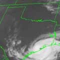
Sunrise and Arlene is inland...
- Attachments
-
Carla/Alicia/Jerry(In The Eye)/Michelle/Charley/Ivan/Dennis/Katrina/Rita/Wilma/Humberto/Ike/Harvey
Member: National Weather Association
Facebook.com/Weather Infinity
Twitter @WeatherInfinity
Member: National Weather Association
Facebook.com/Weather Infinity
Twitter @WeatherInfinity
Arlene, the movie http://youtu.be/5YI0HJq2aNs