
You HAD to bring that up...MontgomeryCoWx wrote:1983 was a cold Winter!
July: Hot & Humid To End The Month
-
MontgomeryCoWx

- Posts: 2356
- Joined: Wed Dec 14, 2011 4:31 pm
- Location: Weimar, TX
- Contact:
wxman57 wrote:You HAD to bring that up...MontgomeryCoWx wrote:1983 was a cold Winter!
Sorry wxman57!
All signs point to a wet and wild end of the year. I hope it phases with a few polar blasts.
Team #NeverSummer
Texas might get a couple of polar blasts like Feb/2011, but the odds of a cold winter are not good. The Northern Hemisphere's A/C unit is on track to have a record low ice extent.MontgomeryCoWx wrote:wxman57 wrote:You HAD to bring that up...MontgomeryCoWx wrote:1983 was a cold Winter!
Sorry wxman57!
All signs point to a wet and wild end of the year. I hope it phases with a few polar blasts.
http://nsidc.org/arcticseaicenews/
The one caveat is the blocking patterns that seem to be more frequent over the last few years. This resulted in parts of Europe having a very cold late winter/early spring while most of N. America (except Alaska) had mild late winter to record warmth in early spring.In June, the Arctic lost a total of 2.86 million square kilometers (1.10 million square miles) of ice. This is the largest June ice loss in the satellite record. Similar to May, the month was characterized by a period of especially rapid ice loss (discussed in the mid-month entry, June 19th) followed by a period of slower loss. Warm conditions prevailed over most of the Arctic; temperatures at the 925 hPa level (about 3000 feet above the ocean surface) were typically 1 to 4 degrees Celsius (1.8 to 7.2 degrees Fahrenheit) above the 1981 to 2010 average, and as much as 7 to 9 degrees Celsius (12.6 to 16.2 degrees Fahrenheit) above average over northern Eurasia and near southern Baffin Bay.
-
wxman57

- Global Moderator

- Posts: 2621
- Joined: Thu Feb 04, 2010 5:34 am
- Location: Southwest Houston (Westbury)
- Contact:
With the recent lightning deaths locally, I thought you would find this high-speed super slow motion video of a lightning strike quite interesting. Note how when the first leader reaches the ground that it triggers the return stroke from the ground to the cloud:
http://vimeo.com/28457062
http://vimeo.com/28457062


One of the coldest winters, 1976-1977 did not have a lot of snow coverage.texoz wrote:
Texas might get a couple of polar blasts like Feb/2011, but the odds of a cold winter are not good. The Northern Hemisphere's A/C unit is on track to have a record low ice extent.
http://nsidc.org/arcticseaicenews/
The one caveat is the blocking patterns that seem to be more frequent over the last few years. This resulted in parts of Europe having a very cold late winter/early spring while most of N. America (except Alaska) had mild late winter to record warmth in early spring.In June, the Arctic lost a total of 2.86 million square kilometers (1.10 million square miles) of ice. This is the largest June ice loss in the satellite record. Similar to May, the month was characterized by a period of especially rapid ice loss (discussed in the mid-month entry, June 19th) followed by a period of slower loss. Warm conditions prevailed over most of the Arctic; temperatures at the 925 hPa level (about 3000 feet above the ocean surface) were typically 1 to 4 degrees Celsius (1.8 to 7.2 degrees Fahrenheit) above the 1981 to 2010 average, and as much as 7 to 9 degrees Celsius (12.6 to 16.2 degrees Fahrenheit) above average over northern Eurasia and near southern Baffin Bay.
http://forums.khou.com/viewtopic.php?f=2&t=1126
-
amandamarie01
- Posts: 14
- Joined: Wed Feb 03, 2010 11:55 pm
- Location: Clear Lake (home) Pasadena (Work)
- Contact:
Wow - storm really blew up out of no where over here.
edit to specify here as Pasadena (225 & Bearle)
edit to specify here as Pasadena (225 & Bearle)
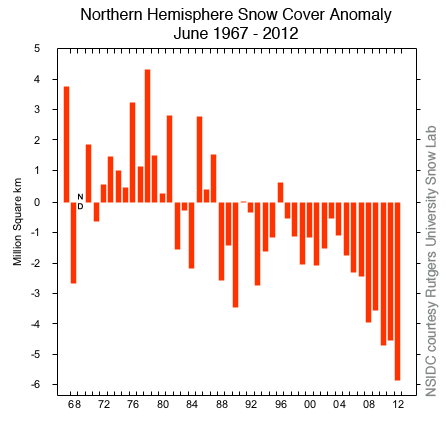
Hmm, the Snow & Ice Data Center has different info.Ptarmigan wrote:One of the coldest winters, 1976-1977 did not have a lot of snow coverage.texoz wrote:
Texas might get a couple of polar blasts like Feb/2011, but the odds of a cold winter are not good. The Northern Hemisphere's A/C unit is on track to have a record low ice extent.
http://nsidc.org/arcticseaicenews/
The one caveat is the blocking patterns that seem to be more frequent over the last few years. This resulted in parts of Europe having a very cold late winter/early spring while most of N. America (except Alaska) had mild late winter to record warmth in early spring.In June, the Arctic lost a total of 2.86 million square kilometers (1.10 million square miles) of ice. This is the largest June ice loss in the satellite record. Similar to May, the month was characterized by a period of especially rapid ice loss (discussed in the mid-month entry, June 19th) followed by a period of slower loss. Warm conditions prevailed over most of the Arctic; temperatures at the 925 hPa level (about 3000 feet above the ocean surface) were typically 1 to 4 degrees Celsius (1.8 to 7.2 degrees Fahrenheit) above the 1981 to 2010 average, and as much as 7 to 9 degrees Celsius (12.6 to 16.2 degrees Fahrenheit) above average over northern Eurasia and near southern Baffin Bay.
http://forums.khou.com/viewtopic.php?f=2&t=1126
That's some amazing video. I had known about leaders, but didn't realize they were "searching" for the return stroke like that. I get the feeling there's more we don't know about lightning than we know, i.e. the sprites into space.wxman57 wrote:With the recent lightning deaths locally, I thought you would find this high-speed super slow motion video of a lightning strike quite interesting. Note how when the first leader reaches the ground that it triggers the return stroke from the ground to the cloud:
http://vimeo.com/28457062
-
Poltracker
- Posts: 44
- Joined: Wed Feb 03, 2010 7:38 pm
- Location: Deer Park, Texas
- Contact:
Yikes! the lightning in that storm was pretty fierce. Electric flicked a few times. It's moving on northward now.amandamarie01 wrote:Wow - storm really blew up out of no where over here.
edit to specify here as Pasadena (225 & Bearle)
-
amandamarie01
- Posts: 14
- Joined: Wed Feb 03, 2010 11:55 pm
- Location: Clear Lake (home) Pasadena (Work)
- Contact:
It sure was - fierce and close! We never lost power but apparently Pasadena Refining wasn't as luckily. Can you see the black smoke from their burn-off over there in Deer Park?Poltracker wrote:amandamarie01 wrote:Wow - storm really blew up out of no where over here.
edit to specify here as Pasadena (225 & Bearle)
Yikes! the lightning in that storm was pretty fierce. Electric flicked a few times. It's moving on northward now.
-
Poltracker
- Posts: 44
- Joined: Wed Feb 03, 2010 7:38 pm
- Location: Deer Park, Texas
- Contact:
amandamarie01 wrote:It sure was - fierce and close! We never lost power but apparently Pasadena Refining wasn't as luckily. Can you see the black smoke from their burn-off over there in Deer Park?Poltracker wrote:amandamarie01 wrote:Wow - storm really blew up out of no where over here.
edit to specify here as Pasadena (225 & Bearle)
Yikes! the lightning in that storm was pretty fierce. Electric flicked a few times. It's moving on northward now.
Yeah! Pouring again. Interesting observation about wind directions. The rain is slanting toward the south and the plumes from the flares at Pasadena Refing are moving south until they reach the higher level then are reversing and moving north with the clouds.

Wow, instantaneous N-S solid red line along the North Freeway. It's just like yesterday but a few miles east.
-
srainhoutx

- Site Admin

- Posts: 19616
- Joined: Tue Feb 02, 2010 2:32 pm
- Location: Maggie Valley, NC
- Contact:
Tireman4 reports a very heavy storm with torrential rains for the past hour in the Gulfgate area.
Carla/Alicia/Jerry(In The Eye)/Michelle/Charley/Ivan/Dennis/Katrina/Rita/Wilma/Humberto/Ike/Harvey
Member: National Weather Association
Facebook.com/Weather Infinity
Twitter @WeatherInfinity
Member: National Weather Association
Facebook.com/Weather Infinity
Twitter @WeatherInfinity
-
srainhoutx
- Site Admin
- Posts: 19616
- Joined: Tue Feb 02, 2010 2:32 pm
- Location: Maggie Valley, NC
- Contact:
FLOOD ADVISORY
NATIONAL WEATHER SERVICE HOUSTON/GALVESTON TX
342 PM CDT TUE JUL 17 2012
TXC201-339-172245-
/O.NEW.KHGX.FA.Y.0104.120717T2042Z-120717T2245Z/
/00000.N.ER.000000T0000Z.000000T0000Z.000000T0000Z.OO/
HARRIS TX-MONTGOMERY TX-
342 PM CDT TUE JUL 17 2012
THE NATIONAL WEATHER SERVICE IN LEAGUE CITY HAS ISSUED A
* URBAN AND SMALL STREAM FLOOD ADVISORY FOR...
CENTRAL HARRIS COUNTY IN SOUTHEAST TEXAS...
SOUTHERN MONTGOMERY COUNTY IN SOUTHEAST TEXAS...
* UNTIL 545 PM CDT
* AT 333 PM CDT...DOPPLER RADAR INDICATED HEAVY RAIN DUE TO
A CLUSTER OF THUNDERSTORMS EXTENDING FROM HOUSTON TO THE
WOODLANDS WHICH IS MOVING NORTH AROUND 10 MPH. THIS CLUSTER OF
STORMS WILL LIKELY CAUSE URBAN AND SMALL STREAM FLOODING IN THE
ADVISORY AREA. UP TO 2 INCHES OF RAIN HAS FALLEN IN THE PAST HOUR.
AN ADDITIONAL 1 TO 2 INCHES OF RAIN IS LIKELY IN THIS AREA.
* SOME LOCATIONS THAT WILL EXPERIENCE MINOR FLOODING INCLUDE
HOUSTON...SPRING...THE WOODLANDS...CLOVERLEAF...SOUTH HOUSTON...
ALDINE...GALENA PARK...JACINTO CITY...OAK RIDGE NORTH...SHENANDOAH...
CHATEAU WOODS AND WOODLOCH.
- Attachments
-
Carla/Alicia/Jerry(In The Eye)/Michelle/Charley/Ivan/Dennis/Katrina/Rita/Wilma/Humberto/Ike/Harvey
Member: National Weather Association
Facebook.com/Weather Infinity
Twitter @WeatherInfinity
Member: National Weather Association
Facebook.com/Weather Infinity
Twitter @WeatherInfinity
-
weatherguy425
- Pro Met

- Posts: 830
- Joined: Wed Feb 03, 2010 7:45 pm
- Location: Atlanta, Georgia
- Contact:
Also watching the Kingwood area and northeastern Harris county for new cell growth. An outflow boundary is booking west from Liberty county, and another boundary appears to be sagging east from the I45 convection. I'm already under some extremely dark Cu bases, so let's see what happens!
-
biggerbyte
- Posts: 1142
- Joined: Thu Feb 04, 2010 12:15 am
- Location: Porter, Texas. (Montgomery County)
- Contact:
LOL
After all these days of mediocre rainfall, Porter is getting dumped on. It is pretty bad over here right now.
After all these days of mediocre rainfall, Porter is getting dumped on. It is pretty bad over here right now.
-
srainhoutx
- Site Admin
- Posts: 19616
- Joined: Tue Feb 02, 2010 2:32 pm
- Location: Maggie Valley, NC
- Contact:
SEVERE WEATHER STATEMENT
NATIONAL WEATHER SERVICE HOUSTON/GALVESTON TX
356 PM CDT TUE JUL 17 2012
TXC201-339-172104-
/O.CAN.KHGX.SV.W.0137.000000T0000Z-120717T2115Z/
HARRIS TX-MONTGOMERY TX-
356 PM CDT TUE JUL 17 2012
...THE SEVERE THUNDERSTORM WARNING FOR EXTREME NORTHWESTERN HARRIS
AND MONTGOMERY COUNTIES IS CANCELLED...
THE STORM WHICH PROMPTED THE WARNING HAS WEAKENED BELOW SEVERE
LIMITS...AND NO LONGER POSE AN IMMEDIATE THREAT TO LIFE OR
PROPERTY. THEREFORE THE WARNING HAS BEEN CANCELLED. HOWEVER...
HEAVY RAIN IS STILL LIKELY WITH THUNDERSTORMS IN THE AREA.
Carla/Alicia/Jerry(In The Eye)/Michelle/Charley/Ivan/Dennis/Katrina/Rita/Wilma/Humberto/Ike/Harvey
Member: National Weather Association
Facebook.com/Weather Infinity
Twitter @WeatherInfinity
Member: National Weather Association
Facebook.com/Weather Infinity
Twitter @WeatherInfinity
That is the data source I used. I used North America excluding Greenland.texoz wrote:Hmm, the Snow & Ice Data Center has different info.Ptarmigan wrote:
One of the coldest winters, 1976-1977 did not have a lot of snow coverage.
http://forums.khou.com/viewtopic.php?f=2&t=1126
http://climate.rutgers.edu/snowcover/fi ... ov.nam.txt
-
txflagwaver

- Posts: 411
- Joined: Wed Feb 03, 2010 2:37 pm
- Location: Seabrook/Kemah
- Contact:
I am at 225 and East Blvd..these storms are being "born" just to my north and west. Incredible view from here.
-
weatherguy425
- Pro Met
- Posts: 830
- Joined: Wed Feb 03, 2010 7:45 pm
- Location: Atlanta, Georgia
- Contact:
For the VERY few of us who could actually use a little more rain, this is not exactly what I was wanting to see. Hopefully the ridge won't become to stubborn.
http://www.cpc.ncep.noaa.gov/products/p ... ns/610day/
**Sorry, couldn't get image down to size to attach.
http://www.cpc.ncep.noaa.gov/products/p ... ns/610day/
**Sorry, couldn't get image down to size to attach.
-
- Information
-
Who is online
Users browsing this forum: Ahrefs [Bot], Bing [Bot], Cpv17, tireman4 and 11 guests