
BULLETIN
HURRICANE SANDY INTERMEDIATE ADVISORY NUMBER 28A
NWS NATIONAL HURRICANE CENTER MIAMI FL AL182012
800 AM EDT MON OCT 29 2012
...SANDY NOW MOVING NORTH-NORTHWESTWARD AND ACCELERATING...
...EXPECTED TO BRING LIFE-THREATENING STORM SURGE AND COASTAL
HURRICANE WINDS PLUS HEAVY APPALACHIAN SNOWS...
SUMMARY OF 800 AM EDT...1200 UTC...INFORMATION
----------------------------------------------
LOCATION...36.8N 71.1W
ABOUT 265 MI...425 KM SE OF ATLANTIC CITY NEW JERSEY
ABOUT 310 MI...505 KM SSE OF NEW YORK CITY
MAXIMUM SUSTAINED WINDS...85 MPH...140 KM/H
PRESENT MOVEMENT...NNW OR 330 DEGREES AT 20 MPH...32 KM/H
MINIMUM CENTRAL PRESSURE...946 MB...27.94 INCHES
WATCHES AND WARNINGS
--------------------
CHANGES WITH THIS ADVISORY...
NONE.
SUMMARY OF WATCHES AND WARNINGS IN EFFECT...
A TROPICAL STORM WARNING IS IN EFFECT FOR...
* NORTH OF SURF CITY TO DUCK NORTH CAROLINA
* PAMLICO AND ALBEMARLE SOUNDS
* BERMUDA
IN ADDITION...HURRICANE-FORCE WINDS ARE EXPECTED ALONG PORTIONS OF
THE COAST BETWEEN CHINCOTEAGUE VIRGINIA AND CHATHAM MASSACHUSETTS.
THIS INCLUDES THE TIDAL POTOMAC FROM COBB ISLAND TO SMITH POINT...
THE MIDDLE AND UPPER CHESAPEAKE BAY...DELAWARE BAY...AND THE COASTS
OF THE NORTHERN DELMARVA PENINSULA...NEW JERSEY...THE NEW YORK CITY
AREA...LONG ISLAND...CONNECTICUT...AND RHODE ISLAND.
TROPICAL-STORM-FORCE WINDS ARE EXPECTED NORTH OF CHATHAM TO
MERRIMACK RIVER MASSACHUSETTS...THE LOWER CHESAPEAKE BAY...AND
SOUTH OF CHINCOTEAGUE TO DUCK NORTH CAROLINA...THE NORTHERN
ENDPOINT OF THE TROPICAL STORM WARNING.
OTHER COASTAL AND INLAND WATCHES AND WARNINGS ARE IN EFFECT FOR
THESE AREAS. PLEASE SEE STATEMENTS FROM LOCAL NATIONAL WEATHER
SERVICE FORECAST OFFICES.
FOR STORM INFORMATION SPECIFIC TO YOUR AREA IN THE UNITED
STATES...INCLUDING POSSIBLE INLAND WATCHES AND WARNINGS...PLEASE
MONITOR PRODUCTS ISSUED BY YOUR LOCAL NATIONAL WEATHER SERVICE
FORECAST OFFICE. FOR STORM INFORMATION SPECIFIC TO YOUR AREA OUTSIDE
THE UNITED STATES...PLEASE MONITOR PRODUCTS ISSUED BY YOUR NATIONAL
METEOROLOGICAL SERVICE.
DISCUSSION AND 48-HOUR OUTLOOK
------------------------------
AT 800 AM EDT...1200 UTC...THE CENTER OF HURRICANE SANDY WAS LOCATED
NEAR LATITUDE 36.8 NORTH...LONGITUDE 71.1 WEST. SANDY IS NOW MOVING
TOWARD THE NORTH-NORTHWEST NEAR 20 MPH...32 KM/H. A TURN TOWARD THE
NORTHWEST IS EXPECTED LATER THIS MORNING...FOLLOWED BY A TURN TOWARD
THE WEST-NORTHWEST TONIGHT. ON THE FORECAST TRACK...THE CENTER OF
SANDY WILL MOVE OVER THE COAST OF THE MID-ATLANTIC STATES THIS
EVENING OR TONIGHT.
REPORTS FROM AN AIR FORCE HURRICANE HUNTER AIRCRAFT INDICATE THAT
THE MAXIMUM SUSTAINED WINDS REMAIN NEAR 85 MPH...140 KM/H...WITH
HIGHER GUSTS. SANDY IS EXPECTED TO TRANSITION INTO A FRONTAL OR
WINTERTIME LOW PRESSURE SYSTEM PRIOR TO LANDFALL. HOWEVER...THIS
TRANSITION WILL NOT BE ACCOMPANIED BY A WEAKENING OF THE SYSTEM...
AND IN FACT...A LITTLE STRENGTHENING IS POSSIBLE DURING THIS
PROCESS. SANDY IS EXPECTED TO WEAKEN AFTER MOVING INLAND.
HURRICANE-FORCE WINDS EXTEND OUTWARD UP TO 175 MILES...280 KM...FROM
THE CENTER...AND TROPICAL-STORM-FORCE WINDS EXTEND OUTWARD UP TO 485
MILES...780 KM. SUSTAINED TROPICAL-STORM-FORCE WINDS ARE OCCURRING
ALONG THE COASTS OF SOUTHERN NEW JERSEY...DELAWARE...AND EASTERN
VIRGINIA...AND EXTEND AS FAR INLAND AS THE CENTRAL AND SOUTHERN
CHESAPEAKE BAY.
THE MINIMUM CENTRAL PRESSURE ESTIMATED FROM HURRICANE HUNTER
AIRCRAFT DATA IS 946 MB...27.94 INCHES.
HAZARDS AFFECTING LAND
----------------------
WIND...TROPICAL STORM CONDITIONS...OR GALE FORCE WINDS...ARE ALREADY
OCCURRING OVER PORTIONS OF THE MID-ATLANTIC STATES FROM NORTH
CAROLINA NORTHWARD TO LONG ISLAND. GALE FORCE WINDS ARE EXPECTED
TO CONTINUE TO SPREAD OVER OTHER PORTIONS OF THE MID-ATLANTIC
COAST...NEW YORK CITY...AND SOUTHERN NEW ENGLAND LATER THIS
MORNING. WINDS OF HURRICANE FORCE COULD REACH THE MID-ATLANTIC
STATES...INCLUDING NEW YORK CITY AND LONG ISLAND...LATER TODAY.
WINDS AFFECTING THE UPPER FLOORS OF HIGH-RISE BUILDINGS WILL BE
SIGNIFICANTLY STRONGER THAN THOSE NEAR GROUND LEVEL.
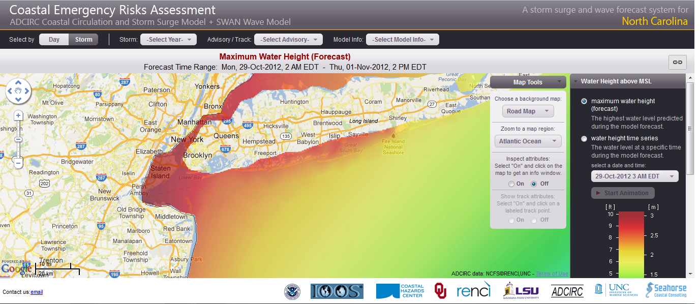
STORM SURGE...THE COMBINATION OF AN EXTREMELY DANGEROUS STORM SURGE
AND THE TIDE WILL CAUSE NORMALLY DRY AREAS NEAR THE COAST TO BE
FLOODED BY RISING WATERS. THE WATER COULD REACH THE FOLLOWING
DEPTHS ABOVE GROUND IF THE PEAK SURGE OCCURS AT THE TIME OF HIGH
TIDE...
NC NORTH OF SURF CITY INCLUDING PAMLICO/ALBEMARLE SOUNDS...4 TO 6 FT
SE VA AND DELMARVA INCLUDING LOWER CHESAPEAKE BAY...2 TO 4 FT
UPPER AND MIDDLE CHESAPEAKE BAY...1 TO 3 FT
LONG ISLAND SOUND...RARITAN BAY...AND NEW YORK HARBOR...6 TO 11 FT
ELSEWHERE FROM OCEAN CITY MD TO THE CT/RI BORDER...4 TO 8 FT
CT/RI BORDER TO THE SOUTH SHORE OF CAPE COD INCLUDING BUZZARDS
BAY AND NARRAGANSETT BAY...3 TO 6 FT
CAPE COD TO THE MA/NH BORDER INCLUDING CAPE COD BAY...2 TO 4 FT
MA/NH BORDER TO THE U.S./CANADA BORDER...1 TO 3 FT
SURGE-RELATED FLOODING DEPENDS ON THE RELATIVE TIMING OF THE SURGE
AND THE TIDAL CYCLE...AND CAN VARY GREATLY OVER SHORT DISTANCES.
GIVEN THE LARGE WIND FIELD ASSOCIATED WITH SANDY...ELEVATED WATER
LEVELS COULD SPAN MULTIPLE TIDE CYCLES RESULTING IN REPEATED AND
EXTENDED PERIODS OF COASTAL AND BAYSIDE FLOODING. IN ADDITION...
ELEVATED WATERS COULD OCCUR FAR REMOVED FROM THE CENTER OF SANDY.
FURTHERMORE...THESE CONDITIONS WILL OCCUR REGARDLESS OF WHETHER
SANDY IS A TROPICAL OR POST-TROPICAL CYCLONE. FOR INFORMATION
SPECIFIC TO YOUR AREA...PLEASE SEE PRODUCTS ISSUED BY YOUR LOCAL
NATIONAL WEATHER SERVICE OFFICE.
RAINFALL...RAINFALL TOTALS OF 3 TO 6 INCHES ARE EXPECTED OVER FAR
NORTHEASTERN NORTH CAROLINA WITH ISOLATED MAXIMUM TOTALS OF 8 INCHES
POSSIBLE. RAINFALL AMOUNTS OF 4 TO 8 INCHES ARE EXPECTED OVER
PORTIONS OF THE MID ATLANTIC STATES...INCLUDING THE DELMARVA
PENINSULA...WITH ISOLATED MAXIMUM AMOUNTS OF 12 INCHES POSSIBLE.
RAINFALL AMOUNTS OF 1 TO 3 INCHES WITH ISOLATED MAXIMUM AMOUNTS OF
5 INCHES ARE POSSIBLE FROM THE SOUTHERN TIER OF NEW YORK STATE
NORTHEASTWARD THROUGH NEW ENGLAND.
SNOWFALL..SNOW ACCUMULATIONS OF 2 TO 3 FEET ARE EXPECTED IN THE
MOUNTAINS OF WEST VIRGINIA WITH LOCALLY HIGHER TOTALS TODAY THROUGH
WEDNESDAY. 1 TO 2 FEET OF SNOW IS EXPECTED IN THE MOUNTAINS OF
SOUTHWESTERN VIRGINIA TO THE KENTUCKY BORDER...WITH 12 TO 18 INCHES
OF SNOW IN THE MOUNTAINS NEAR THE NORTH CAROLINA/TENNESSEE BORDER
AND IN THE MOUNTAINS OF WESTERN MARYLAND.
SURF...DANGEROUS SURF CONDITIONS WILL CONTINUE FROM FLORIDA THROUGH
NEW ENGLAND FOR THE NEXT COUPLE OF DAYS.
NEXT ADVISORY
-------------
NEXT COMPLETE ADVISORY...1100 AM EDT.
$$
FORECASTER STEWART
East Coast High Impact Hurricane/Post Tropical Storm Sandy
-
srainhoutx

- Site Admin

- Posts: 19616
- Joined: Tue Feb 02, 2010 2:32 pm
- Location: Maggie Valley, NC
- Contact:
- Attachments
-
Carla/Alicia/Jerry(In The Eye)/Michelle/Charley/Ivan/Dennis/Katrina/Rita/Wilma/Humberto/Ike/Harvey
Member: National Weather Association
Facebook.com/Weather Infinity
Twitter @WeatherInfinity
Member: National Weather Association
Facebook.com/Weather Infinity
Twitter @WeatherInfinity
-
srainhoutx
- Site Admin
- Posts: 19616
- Joined: Tue Feb 02, 2010 2:32 pm
- Location: Maggie Valley, NC
- Contact:
Code: Select all
Product: Air Force Temp Drop (Dropsonde) Message (UZNT13 KNHC)
Transmitted: 29th day of the month at 12:34Z
Aircraft: Air Force Aircraft (Last 3 digits of the tail number are 302)
Storm Number: 18
Storm Name: Sandy (flight in the North Atlantic basin)
Mission Number: 23
Observation Number: 21

Part A...


Date: Near the closest hour of 12Z on the 29th day of the month
Highest Mandatory Level For Which Wind Was Reported: 700mb
Coordinates: 35.7N 72.1W
Location: 196 miles (315 km) to the E (81°) from Cape Hatteras, NC, USA.
Marsden Square: 116 (About)

Level Geo. Height Air Temp. Dew Point Wind Direction Wind Speed
968mb (28.59 inHg) Sea Level (Surface) 18.0°C (64.4°F) 17.5°C (63.5°F) 270° (from the W) 74 knots (85 mph)
1000mb -279m (-915 ft) This level does not exist in this area of the storm above the surface level.
925mb 386m (1,266 ft) 13.2°C (55.8°F) 12.7°C (54.9°F) 280° (from the W) 98 knots (113 mph)
850mb 1,092m (3,583 ft) 9.6°C (49.3°F) 8.6°C (47.5°F) 275° (from the W) 88 knots (101 mph)
700mb 2,727m (8,947 ft) 9.0°C (48.2°F) 8.9°C (48.0°F) 260° (from the W) 29 knots (33 mph)

Information About Radiosonde:
- Launch Time: 12:09Z
- About Sonde: A descending radiosonde tracked automatically by satellite navigation with no solar or infrared correction.

Remarks Section...


Dropsonde Location: Dropped in maximum wind band.

Splash Location: 35.65N 72.02W
Splash Time: 12:13Z

Location of Highest Altitude where wind was reported: 35.66N 72.1W
Time of Highest Altitude where wind was reported: 12:09:46Z

Location of Lowest Altitude where wind was reported: 35.65N 72.02W
Time of Lowest Altitude where wind was reported: 12:13:39Z

Mean Boundary Level Wind (mean wind in the lowest 500 geopotential meters of the sounding):
- Wind Direction: 275° (from the W)
- Wind Speed: 90 knots (104 mph)

Deep Layer Mean Wind (average wind over the depth of the sounding):
- Wind Direction: 275° (from the W)
- Wind Speed: 68 knots (78 mph)
- Depth of Sounding: From 697mb to 968mb

Average Wind Over Lowest Available 150 geopotential meters (gpm) of the sounding:
- Lowest 150m: 159 gpm - 9 gpm (522 geo. feet - 30 geo. feet)
- Wind Direction: 270° (from the W)
- Wind Speed: 85 knots (98 mph)

Sounding Software Version: AEV 30000


Part B: Data For Significant Levels...


Significant Temperature And Relative Humidity Levels...
Level Air Temperature Dew Point
968mb (Surface) 18.0°C (64.4°F) 17.5°C (63.5°F)
935mb 13.6°C (56.5°F) 12.9°C (55.2°F)
850mb 9.6°C (49.3°F) 8.6°C (47.5°F)
824mb 8.4°C (47.1°F) 7.0°C (44.6°F)
818mb 9.6°C (49.3°F) 7.0°C (44.6°F)
811mb 14.2°C (57.6°F) 11.8°C (53.2°F)
802mb 16.0°C (60.8°F) 13.4°C (56.1°F)
721mb 12.2°C (54.0°F) 11.7°C (53.1°F)
697mb 8.4°C (47.1°F) 8.4°C (47.1°F)

Significant Wind Levels...
Level Wind Direction Wind Speed
968mb (Surface) 270° (from the W) 74 knots (85 mph)
966mb 270° (from the W) 73 knots (84 mph)
962mb 265° (from the W) 85 knots (98 mph)
960mb 270° (from the W) 88 knots (101 mph)
932mb 275° (from the W) 90 knots (104 mph)
925mb 280° (from the W) 98 knots (113 mph)
917mb 275° (from the W) 97 knots (112 mph)
907mb 275° (from the W) 101 knots (116 mph)
859mb 275° (from the W) 100 knots (115 mph)
850mb 275° (from the W) 88 knots (101 mph)
820mb 270° (from the W) 73 knots (84 mph)
803mb 275° (from the W) 46 knots (53 mph)
697mb 260° (from the W) 29 knots (33 mph)
Carla/Alicia/Jerry(In The Eye)/Michelle/Charley/Ivan/Dennis/Katrina/Rita/Wilma/Humberto/Ike/Harvey
Member: National Weather Association
Facebook.com/Weather Infinity
Twitter @WeatherInfinity
Member: National Weather Association
Facebook.com/Weather Infinity
Twitter @WeatherInfinity
-
srainhoutx
- Site Admin
- Posts: 19616
- Joined: Tue Feb 02, 2010 2:32 pm
- Location: Maggie Valley, NC
- Contact:
Morning e-mail from Jeff:
Massive hurricane Sandy intensifies and takes dead aim at the US coast
Life threatening record storm surge flooding likely along the NJ, NYC, Long Island Sound, Long Island, CT, RI. Failure for persons to evacuate coastal locations will place their lives in grave danger.
Damage and human suffering will be high by modern standards with some economic models showing damage estimates potentially rivaling Hurricane Katrina.
Discussion:
As well advertised over the last few days, an epic hurricane event is heading for the US east coast as forecasted. Recon data this morning indicates the central pressure in Sandy has fallen to 946mb or roughly 5-8mb lower than yesterday and 20-25mb lower than the record lowest pressure records along the US mid Atlantic and NE coast. Deep convection has developed near the center of Sandy overnight and flight level winds of 102kts were recorded, although the system is likely not transferring all of this wind energy to the surface due to a overall lack of deep convection. The wind field is massive with TS force winds currently extending from NC to MA to Bermuda and hurricane force winds covering roughly 200-250 miles near the center. NOAA buoys report a large area of 30-40 foot seas over the western and northwestern Atlantic and coast webcams along the NJ coast show wave heights breaking on the beaches of 8-12 feet currently.
It is likely Sandy will continue to intensify as it moves over the warm Gulf stream in the next 6-8 hours as a tropical hurricane. As Sandy turns toward the NW and WNW over the next 12-18 hours (In fact recon just reported that a NNW turn has begun) the system will gradually entrain frontal air masses currently on the edges of the circulation deeper into the system and the transition toward a post tropical system should be nearing completion as Sandy strikes the New Jersey coast although thus far this system has been able to protect its fragile inner core and maintain a warm core tropical entity in the face of otherwise adverse conditions.
Regardless of where Sandy crosses the coast as a warm core tropical system or a cold core post tropical system…the devastating impacts will be the same.
Impacts:
Prolonged and devastating impacts are likely.
Storm Surge:
Record and life threatening storm surge event for the NJ, NYC, Long Island, CT, RI coasts.
Water level rise is already in progress along the coast this morning as massive wave action results in wave run-up and full moon lunar tides result in higher than normal tidal action. Additionally, onshore winds of TS force are reaching the coast and starting to pile water onto the beaches. Most locations have just peaked for the morning high tide with water levels already running 8.0 ft in parts of Long Island Sound, but this morning high tide will likely become trapped near the coast as wind increase over the next few hours.
Sandy will be nearing landfall nearly right on top of or just after the evening high tide cycle and it is this tide that is forecasted to bring record water levels to the coast. Current extra-tropical storm surge modeling brings a total water level rise of 12-13 feet to Long Island Sound including the CT coast, and eastern portions of New York City. On the New Jersey coast, north of where the center of Sandy make landfall a record 11-12 water level rise is forecast at Sandy Hook and into Raritan Bay exceeding the previous record of 10.1 ft!
At New York Harbor and the Battery a total water level rise of 11.0 ft is expected with 12.0ft at Point Bergen, NY. These water levels are 5-6 feet higher than Hurricane Irene last summer and it is highly likely that sea water is going to flood the NYC subway system and submerge portions of lower Manhattan. It is estimated that seawater flooding the NYC subway system could cause at least 10 billion in damage.
Ocean City, MD to CT/RI state line: 4-8 foot surge
Sandy Hook, NJ to Bridgeport, CT including NYC, western Long Island Sound, Hudson River, Raritan Bay: 8-12 ft
CT/RI including Cape Cod, Buzzards Bay and Narragansett Bay: 3-6 ft
Cape Code Bay and Boston: 2-4 ft
MA/NH to US/Canada border: 1-3 ft
SE VA, DELMARVA, lower Chesapeake Bay: 2-4 ft
Massive offshore wave action of 35-45 ft will break on the beaches in the 10-15 foot range on top of the storm surge water level rise. Expecting the surge to overtop and breach protective dune systems and seawalls with large destructive waves aimed into coastal structures. Many structures near the beach will be damaged to the point of total collapse and some will be washed into the ocean along the entire NJ, NY, Long Island, CT, RI coasts.
Extra-tropical Storm Surge Forecast Points:
http://www.nws.noaa.gov/mdl/etsurge/ind ... ®ion=ne
NYC Surge Inundation Potential:
http://anglicanprayer.files.wordpress.c ... c-nyc1.png
NWS MT Holly, NY Public Plea:
“If you are being asked to evacuate a coastal location by state and local officials, please do so.
•If you are reluctant to evacuate, and you know someone who rode out the ‘62 storm on the barrier islands, ask them if they would do it again.
•If you are still reluctant, think about your loved ones, think about the emergency responders who will be unable to reach you when you make the panicked phone call to be rescued, think about the rescue/recovery teams who will rescue you if you are injured or recover your remains if you do not survive.
•Sandy is an extremely dangerous storm. There will be major property damage, injuries are probably unavoidable, but the goal is zero fatalities.
•If you think the storm is over-hyped and exaggerated, please err on the side of caution. You can call me up on Friday (contact information is at the end of this briefing) and yell at me all you want.
•I will listen to your concerns and comments, but I will tell you in advance, I will be very happy that you are alive & well, no matter how much you yell at me.
•Gary Szatkowski – National Weather Service Mount Holly”
Winds:
Winds near the center of Sandy have increased to 85mph this morning and NHC suggest that Sandy may intensify to a high end category 1 or low end category 2 hurricane prior to landfall. Widespread winds of 45-55mph with gust to 75-85mph will affect the entire area from the DELMARVA to MA with more frequent hurricane force wind gust aimed at the NJ and NY area. This will be a prolonged event with sustained winds above 40mph for 24-48 hours and sustained winds of 50-60mph along the NJ and NY coast for 12-16 hours.
Widespread wind damage is expect to extend from NC to Canada and inland to the OH Valley. In fact the circulation is so large that strong winds on the western side will likely produce large waves on Lake Michigan and strong winds in Chicago.
Extensive vegetation damage will occur with many trees being downed as the ground saturates. Massive and long lasting power outages will be common and there is concern this morning that the entire NE electric grid could be brought down due to the potential for such widespread damage to lines and potential flooding of sub-stations.
Rainfall:
A very heavy rainfall band has established on the far western flank of Sandy this morning right across the Washington DC metro area. Rainfall rates in this low level convergent band are on the order of .5 to 1.5 inches per hour and this band will likely remain nearly stationary for much of the day. Rainfall amounts of 4-8 inches will be likely to the south and west of where the center of Sandy crosses the coast with isolated totals of 12-15 inches possible resulting in the potential for catastrophic inland flash flooding. Dry air wrapping into the eastern flank of Sandy may actually help mitigate heavy rainfall over a large part of New England with the worst impacts from rainfall being over the DELMARVA WNW into PA , VA, and OH.
Snow:
Showing how rare of an event this is, heavy prolonged snow is expected on the western flank of the system over potions of the higher mountains of NC, WV and eastern OH. Tropical moisture will interact with the cold air to produce potentially incredible snowfall rates and amounts. Amounts of 2-3 feet will be possible in the above mentioned areas.
Aside:
A 17 foot sailing vessel 160 miles from the center of Sandy this morning with 17 persons onboard has lost all engine propulsion overnight and is taking on water in 35-40 foot seas and zero visibility in blowing sea spray. USCG aircraft are onsite, but have aborted an initial rescue attempt due to the sea state and hurricane force winds. US Navy vessels ordered to sea yesterday from Norfolk, VA are also reporting “significant” sea state with massive waves and relentless winds.
- Attachments
-
- 10292012 Jeff image001.gif (28.31 KiB) Viewed 5171 times
Carla/Alicia/Jerry(In The Eye)/Michelle/Charley/Ivan/Dennis/Katrina/Rita/Wilma/Humberto/Ike/Harvey
Member: National Weather Association
Facebook.com/Weather Infinity
Twitter @WeatherInfinity
Member: National Weather Association
Facebook.com/Weather Infinity
Twitter @WeatherInfinity
-
txflagwaver

- Posts: 411
- Joined: Wed Feb 03, 2010 2:37 pm
- Location: Seabrook/Kemah
- Contact:
Thought just occurred to me...Where is the Shuttle Enterprise housed? Is it safe from this storm. JSC was considered to risky coz of storms and it's close proxinity to the coast
-
txflagwaver
- Posts: 411
- Joined: Wed Feb 03, 2010 2:37 pm
- Location: Seabrook/Kemah
- Contact:
-
srainhoutx
- Site Admin
- Posts: 19616
- Joined: Tue Feb 02, 2010 2:32 pm
- Location: Maggie Valley, NC
- Contact:
HURRICANE SANDY DISCUSSION NUMBER 29
NWS NATIONAL HURRICANE CENTER MIAMI FL AL182012
1100 AM EDT MON OCT 29 2012
SANDY IS MAINTAINING A SMALL AREA OF DEEP CONVECTION NEAR THE
CENTER...WITH BOTH AIR FORCE RESERVE RECONNAISSANCE AIRCRAFT DATA
AND VARIOUS MICROWAVE SATELLITE DATA INDICATING A 20 N MI DIAMETER
EYE HAS DEVELOPED SINCE THE PREVIOUS ADVISORY. MAXIMUM 700 MB
FLIGHT-LEVEL WINDS HAVE BEEN 94 KT IN THE SOUTHERN QUADRANT...AND
SFMR-ADJUSTED SURFACE WINDS OF 80-83 KT HAVE BEEN OBSERVED IN THE
SOUTHWESTERN QUADRANT MORE THAN 90 N MI FROM THE CENTER. THE
AIRCRAFT DATA ALSO INDICATE THAT THE CENTRAL PRESSURE HAS FALLEN A
LITTLE...TO ABOUT 943 MB. BASED ON THE LATEST RECONNAISSANCE
DATA...THE INITIAL INTENSITY HAS BEEN INCREASED TO 80 KT.
RECONNAISSANCE CENTER FIXES INDICATE THAT SANDY HAS BEEN GRADUALLY
TURNING TO THE LEFT AND IS NOW MOVING NORTH-NORTHWESTWARD OR ABOUT
330/16 KT. THE LATEST RECON FIXES HAVE BEEN FALLING ON THE PREVIOUS
FORECAST TRACK...AND SO HAVE THE LATEST 12Z NHC FORECAST MODELS.
THEREFORE...NO SIGNIFICANT CHANGES TO THE ADVISORY PREVIOUS TRACK
OR REASONING ARE REQUIRED. SANDY IS NOW LOCATED NORTH OF THE AXIS
OF A STRONG NEGATIVELY TILTED MID-/UPPER-LEVEL TROUGH...AND THE
HURRICANE SHOULD TURN NORTHWESTWARD VERY SOON. LANDFALL ALONG OR
JUST SOUTH OF THE SOUTHERN NEW JERSEY COAST IS EXPECTED LATE THIS
EVENING...AT WHICH TIME A TURN TO THE WEST-NORTHWEST IS EXPECTED.
AFTER MOVING INLAND OVER THE MID-ATLANTIC STATES A DECREASE IN
FORWARD SPEED IS EXPECTED. BY 48 HOURS...THE POST-TROPICAL CYCLONE
IS FORECAST TO MOVE NORTHWARD AND THEN NORTHEASTWARD. THE OFFICIAL
NHC FORECAST TRACK IS SIMILAR TO THE PREVIOUS ADVISORY TRACK...AND
LIES CLOSE TO A BLEND OF THE CONSENSUS MODELS TV15 AND TVCN.
SANDY IS CURRENTLY TRAVERSING A NARROW RIDGE OF WARM SSTS AROUND
27C...WHICH ARE ASSOCIATED WITH THE GULF STREAM. THIS EXTRA
LOW-LEVEL HEAT INPUT HAS LIKELY CONTRIBUTED TO THE RECENT INCREASE
IN CONVECTION AROUND THE EYE. HOWEVER...SANDY WILL BE MOVING OVER
THE NORTH WALL OF THE GULFSTREAM WITHIN THE NEXT 3 HOURS...WHICH
WILL BRING A HALT TO ANY SIGNIFICANT INNER-CORE CONVECTIVE
DEVELOPMENT. HOWEVER...THIS SHOULD HAVE LITTLE IMPACT ON THE
OVERALL INTENSITY OR THE SIZE OF THE EXTREMELY LARGE WIND FIELD
THAT IS NOW MORE THAN 1000 N MI IN DIAMETER. AT THE MOMENT...
HURRICANE FORCE WINDS ARE ONLY OCCURRING IN THE SOUTHWEST
QUADRANT...BUT MODEL GUIDANCE SUGGESTS THAT THESE COULD SPREAD INTO
THE NORTHERN SEMICIRCLE BEFORE LANDFALL.
SURFACE DATA INDICATE THAT WELL-DEFINED WARM AND COLD FRONTS LIE
VERY NEAR THE CENTER OF SANDY...AND THE COMBINATION OF COLDER OCEAN
WATER AND NEARBY FRONTAL SYSTEMS ARE EXPECTED TO RESULT IN
EXTRATROPICAL TRANSITION BEFORE THE CENTER OF THE CYCLONE REACHES
THE COAST. HOWEVER...THIS TRANSFORMATION WILL NOT DIMINISH THE
OVERALL IMPACTS FROM WINDS TO HURRICANE STRENGTH...LIFE-THREATENING
STORM SURGE... AND FLOODING RAINS ASSOCIATED WITH THIS DANGEROUS
WEATHER SYSTEM. BASED ON THE GLOBAL MODELS...THE CYCLONE SHOULD
WEAKEN FAIRLY RAPIDLY AFTER LANDFALL.
INTERESTS ARE REMINDED NOT TO FOCUS ON THE CENTER OR THE EXACT
FORECAST TRACK OF THIS SYSTEM...SINCE STRONG WINDS COVER AN AREA
SEVERAL HUNDRED MILES ACROSS...AND THE HIGHEST WINDS WILL NOT
NECESSARILY BE NEAR THE CENTER...ESPECIALLY JUST A FEW HUNDRED FEET
ABOVE THE GROUND.
AS NOTED IN PREVIOUS ADVISORIES...TO AVOID A HIGHLY DISRUPTIVE
CHANGE FROM TROPICAL TO NON-TROPICAL WARNINGS WHEN SANDY BECOMES
POST-TROPICAL...THE WIND HAZARD NORTH OF THE TROPICAL STORM WARNING
AREA WILL CONTINUE TO BE CONVEYED THROUGH HIGH WIND WATCHES AND
WARNINGS ISSUED BY LOCAL NATIONAL WEATHER SERVICE OFFICES.
FORECAST POSITIONS AND MAX WINDS
INIT 29/1500Z 37.5N 71.5W 80 KT 90 MPH
12H 30/0000Z 39.0N 74.0W 80 KT 90 MPH...POST-TROP/EXTRATROP
24H 30/1200Z 39.9N 76.7W 60 KT 70 MPH...POST-TROP/EXTRATROP
36H 31/0000Z 40.4N 77.9W 45 KT 50 MPH...POST-TROP/EXTRATROP
48H 31/1200Z 41.5N 77.2W 35 KT 40 MPH...POST-TROP/EXTRATROP
72H 01/1200Z 44.5N 75.6W 30 KT 35 MPH...POST-TROP/EXTRATROP
96H 02/1200Z 45.9N 72.7W 25 KT 30 MPH...POST-TROP/EXTRATROP
120H 03/1200Z 47.5N 68.5W 20 KT 25 MPH...POST-TROP/EXTRATROP
$$
FORECASTER STEWART
- Attachments
-
Carla/Alicia/Jerry(In The Eye)/Michelle/Charley/Ivan/Dennis/Katrina/Rita/Wilma/Humberto/Ike/Harvey
Member: National Weather Association
Facebook.com/Weather Infinity
Twitter @WeatherInfinity
Member: National Weather Association
Facebook.com/Weather Infinity
Twitter @WeatherInfinity
-
srainhoutx
- Site Admin
- Posts: 19616
- Joined: Tue Feb 02, 2010 2:32 pm
- Location: Maggie Valley, NC
- Contact:
Update from Jeff:
Recon aircraft report the central pressure has fallen to 943mb and the winds have been increased to 90mph sustained.
Record breaking storm surge event heading for New York and New Jersey. Potential for high loss of life if residents remain on the coast!
Sandy is making the wide sweeping turn toward the NNW at this time and should turn NW shortly with the central expected to cross the southern New Jersey coast this evening. On this track life threatening storm surge and incredible wave action will impact the New Jersey and New York coasts. Coastal structures less than 15 feet above sea level will be destroyed and likely carried to sea! This is going to obliterate the New Jersey coastline and portions of Long Island.
Based on the latest data, the storm surge values for New York City have been increased into the 12-14 foot level! Previous storm surge records will be exceeded by 1-4 feet over the entire region potentially resulting in catastrophic damage. See below the forecasted total water level rises for this evening from NWS NYC:
WATER LEVELS FOR THIS EVENING AND TONIGHTS HIGH TIDE CYCLE
...NY HARBOR WATER LEVELS FOR THIS EVENING...
COASTAL............TIME OF......FORECAST TOTAL.....FLOOD.....
LOCATION...........HIGH TIDE.....WATER LEVEL.......CATEGORY..
...................................(MLLW)....................
THE BATTERY NYC.....813 PM.........10-12.............MAJOR....
BERGEN POINT NY.....814 PM.........12-13.............MAJOR....
...WESTERN L.I. SOUND WATER LEVELS FOR TONIGHT...
COASTAL............TIME OF......FORECAST TOTAL.....FLOOD.....
LOCATION...........HIGH TIDE.....WATER LEVEL.......CATEGORY..
...................................(MLLW)....................
KINGS POINT NY......1227 AM........15-16............MAJOR....
LATTINGTOWN NY......1205 AM........15-16............MAJOR....
STAMFORD CT.........1201 AM........14-15............MAJOR....
BRIDGEPORT CT.......1158 PM........14-15............MAJOR....
NEW HAVEN CT........1157 PM........13-14............MAJOR....
...EASTERN L.I. SOUND WATER LEVELS FOR THIS EVENING...
COASTAL............TIME OF......FORECAST TOTAL.....FLOOD.....
LOCATION...........HIGH TIDE.....WATER LEVEL.......CATEGORY..
...................................(MLLW)....................
NEW LONDON CT.......952 PM.........8.5-9.5..........MAJOR....
...SOUTH SHORE BAYS WATER LEVELS FOR THIS EVENING...
COASTAL............TIME OF......FORECAST TOTAL.....FLOOD.....
LOCATION...........HIGH TIDE.....WATER LEVEL.......CATEGORY..
..................................(MLLW/NGVD)................
E ROCKAWAY INLET NY..814 PM.........12/10.5.........MAJOR....
FREEPORT GAGE NY.....858 PM.........11/10.2.........MAJOR....
JAMAICA BAY NY.......900 PM.......12.2/10...........MAJOR....
ROCKAWAY INLET NY....820 PM.......11.5/9.5..........MAJOR....
POINT LOOKOUT........801 PM.........11/9.9..........MAJOR....
LINDENHURST.........1041 PM.......8.4/8.6...........MAJOR....
...OCEAN WATER LEVELS FOR TONIGHT...
COASTAL............TIME OF......FORECAST TOTAL.....FLOOD.....
LOCATION...........HIGH TIDE.....WATER LEVEL.......CATEGORY..
...................................(MLLW)....................
MONTAUK POINT NY.....923 PM.........7.5-8.5..........MAJOR...
- Attachments
-
- 10292012 Jeff 10AM image001.gif (30.75 KiB) Viewed 6229 times
Carla/Alicia/Jerry(In The Eye)/Michelle/Charley/Ivan/Dennis/Katrina/Rita/Wilma/Humberto/Ike/Harvey
Member: National Weather Association
Facebook.com/Weather Infinity
Twitter @WeatherInfinity
Member: National Weather Association
Facebook.com/Weather Infinity
Twitter @WeatherInfinity
-
jcarr
- Site Admin
- Posts: 42
- Joined: Mon Oct 22, 2012 9:43 am
- Location: Galveston County on the Bay
- Contact:
A Hurricane Helpline has been set up for residents Call 1-888-485-1159 for information on sandy preps and the impact.
Search for open shelters by texting: SHELTER + a zip code to 43362 (4FEMA). Example : Shelter 01234 (std rates apply)
Search for open shelters by texting: SHELTER + a zip code to 43362 (4FEMA). Example : Shelter 01234 (std rates apply)
-
srainhoutx
- Site Admin
- Posts: 19616
- Joined: Tue Feb 02, 2010 2:32 pm
- Location: Maggie Valley, NC
- Contact:
Carla/Alicia/Jerry(In The Eye)/Michelle/Charley/Ivan/Dennis/Katrina/Rita/Wilma/Humberto/Ike/Harvey
Member: National Weather Association
Facebook.com/Weather Infinity
Twitter @WeatherInfinity
Member: National Weather Association
Facebook.com/Weather Infinity
Twitter @WeatherInfinity
-
txflagwaver
- Posts: 411
- Joined: Wed Feb 03, 2010 2:37 pm
- Location: Seabrook/Kemah
- Contact:
They have compiled this resource page to help get everything in one location. This page will be a “running blog” where we will continually adjust links/information as necessary. Bookmark and share the page for future reference.
http://www.texasstormchasers.com/sandy/
http://www.texasstormchasers.com/sandy/
-
srainhoutx
- Site Admin
- Posts: 19616
- Joined: Tue Feb 02, 2010 2:32 pm
- Location: Maggie Valley, NC
- Contact:
Another update from Jeff:
Sandy plowing toward the coast.
NWS Mt Holly, NJ noon briefing:
“Options for it to miss us have run out. This is our worst case scenario. Evening high tide will bring coastal flooding worse than anything we have ever seen. Barrier Islands will be cut-off completely from the mainland. Historic life threatening storm surge is imminent”
Radar Loop:
http://radar.weather.gov/ridge/radar.ph ... 1&loop=yes
Coastal water level rise in progress, sea water already inundating portions of lower Manhattan and N New Jersey. See images below:
- Attachments
-
-
-
Carla/Alicia/Jerry(In The Eye)/Michelle/Charley/Ivan/Dennis/Katrina/Rita/Wilma/Humberto/Ike/Harvey
Member: National Weather Association
Facebook.com/Weather Infinity
Twitter @WeatherInfinity
Member: National Weather Association
Facebook.com/Weather Infinity
Twitter @WeatherInfinity
This storm is going to be studied intensely for years. One of the most unusual TS's to hit the east coast since records have been kept.
One wonders if the anomalous blocking high pressure over Greenland is a new trend due to warmer Arctic ocean. Over the last few years we have seen unusual jet stream patterns & blocking highs. Many scientists are attributing this to the loss of summer Arctic ice and resulting warmer ocean.
Sandy may not be a once-in-a-lifetime event.
-
srainhoutx
- Site Admin
- Posts: 19616
- Joined: Tue Feb 02, 2010 2:32 pm
- Location: Maggie Valley, NC
- Contact:
Carla/Alicia/Jerry(In The Eye)/Michelle/Charley/Ivan/Dennis/Katrina/Rita/Wilma/Humberto/Ike/Harvey
Member: National Weather Association
Facebook.com/Weather Infinity
Twitter @WeatherInfinity
Member: National Weather Association
Facebook.com/Weather Infinity
Twitter @WeatherInfinity
-
srainhoutx
- Site Admin
- Posts: 19616
- Joined: Tue Feb 02, 2010 2:32 pm
- Location: Maggie Valley, NC
- Contact:
Update from Jeff:
Sandy plowing toward the southern/central NJ coast…should make landfall around 5-6pm EDT.
Significant storm surge is overwashing the NJ, MD, DE coast. Water levels are 4-5 feet deep already in coastal towns on the NJ coast with low tide just passing. From this point forward water levels will be rising toward high tide at 800pm EDT along with final push of storm surge and tremendous wave action resulting in a record surge event along the New Jersey coast. Winds shifting to the ESE will drive tremendous water into Raritan Bay and the lower Hudson River. Battery Park is already 5.0 ft above normal at low tide currently or equal to Hurricane Irene last year.
Damaging hurricane force winds are moving onshore. Recon reporting frequent 100-115mph winds at flight level and some of this may translate down in the strong western side rainbands. Pressure has fallen to 940mb…record pressures are about to be established for the NE US. Wind damage is in progress in NYC with trees being blown down and windows being blown out of high rise buildings.
Radar Loop:
http://radar.weather.gov/ridge/radar.ph ... X&loop=yes
Carla/Alicia/Jerry(In The Eye)/Michelle/Charley/Ivan/Dennis/Katrina/Rita/Wilma/Humberto/Ike/Harvey
Member: National Weather Association
Facebook.com/Weather Infinity
Twitter @WeatherInfinity
Member: National Weather Association
Facebook.com/Weather Infinity
Twitter @WeatherInfinity