
Hurricane Cristobal: Near The Bahamas
-
prospects8903
- Posts: 61
- Joined: Thu Aug 21, 2014 9:29 am
- Contact:
I'm seeing talk that the CoC may be reforming more to west...If that's the case do you still believe it's not a GOM storm?

-
TexasBreeze
- Posts: 942
- Joined: Sun Sep 26, 2010 4:46 pm
- Location: NW Houston, TX
- Contact:
18z GFS is no longer out to sea it rides up Fla then up the east coast. Just one model suggestion.
[quote="TexasBreeze"]18z GFS is no longer out to sea it rides up Fla then up the east coast. Just one model suggestion.[/quote
Nice shift to the west on that run.
Nice shift to the west on that run.


Latest forecast on where 96L will go. Yesterday a fish storm, now a westward trend.

Most intensity forecast model have it as a tropical storm by tomorrow.

Most intensity forecast model have it as a tropical storm by tomorrow.
well to me system is a little further south than forecasted
-
srainhoutx

- Site Admin

- Posts: 19616
- Joined: Tue Feb 02, 2010 2:32 pm
- Location: Maggie Valley, NC
- Contact:
As of 8:00AM EDT Saturday...(RECON is currently investigating and finding lower pressures near 1006 MB)
...SPECIAL FEATURES...
A 1008 MB LOW IS LOCATED 10 NM MILES N OF THE COAST OF
HISPANIOLA NEAR 20N70W...MOVING WNW AT 10-15 KT. A SURFACE
TROUGH EXTENDS N FROM THE LOW CENTER TO 26N70W. SCATTERED
MODERATE TO STRONG CONVECTION IS LOCATED OVER HISPANIOLA AND THE
S BAHAMAS FROM 16N-23N BETWEEN 65W-73W. THIS LOW HAS BEEN
GETTING BETTER ORGANIZED IN THE PAST 12 HOURS. GUSTY WINDS AND
HEAVY RAIN ARE EXPECTED ACROSS PUERTO RICO...HISPANIOLA...THE
BAHAMAS...AND THE OPEN WATERS BETWEEN THESE ISLANDS TODAY. HEAVY
RAINS COULD CAUSE LIFE-THREATENING FLASH FLOODS AND MUDSLIDES...
ESPECIALLY IN THE MOUNTAINOUS AREAS OF HISPANIOLA AND PUERTO
RICO. GRADUAL DEVELOPMENT OF THE LOW IS EXPECTED DURING THE NEXT
FEW DAYS AS IT MOVES ALONG OR NORTH OF THE GREATER ANTILLES.
INTERESTS DOWNSTREAM OF THE LOW SHOULD MONITOR CLOSELY THE
PROGRESS OF THIS SYSTEM. CHANCES FOR DEVELOPMENT INTO A TROPICAL
CYCLONE DURING THE NEXT 48 HOURS IS HIGH.
Carla/Alicia/Jerry(In The Eye)/Michelle/Charley/Ivan/Dennis/Katrina/Rita/Wilma/Humberto/Ike/Harvey
Member: National Weather Association
Facebook.com/Weather Infinity
Twitter @WeatherInfinity
Member: National Weather Association
Facebook.com/Weather Infinity
Twitter @WeatherInfinity

Looks like recon may have found a LLC south of Turks & Caicos.
21.51N 72.15W (or close)
21.51N 72.15W (or close)
-
tireman4

- Global Moderator

- Posts: 4488
- Joined: Wed Feb 03, 2010 9:24 pm
- Location: Humble, Texas
- Contact:
TD 4 now?
000
WTNT34 KNHC 232048
TCPAT4
BULLETIN
TROPICAL DEPRESSION FOUR ADVISORY NUMBER 1...CORRECTED
NWS NATIONAL HURRICANE CENTER MIAMI FL AL042014
500 PM AST SAT AUG 23 2014
CORRECTED TYPO IN HEADLINE
...TROPICAL DEPRESSION FORMS OVER THE TURKS AND CAICOS...
...TROPICAL STORM WARNING ISSUED FOR THE TURKS AND CAICOS
AND PORTIONS OF THE BAHAMAS...
SUMMARY OF 500 PM AST...2100 UTC...INFORMATION
----------------------------------------------
LOCATION...21.8N 72.3W
ABOUT 75 MI...120 KM NE OF GREAT INAGUA ISLAND
ABOUT 255 MI...410 KM ESE OF THE CENTRAL BAHAMAS
MAXIMUM SUSTAINED WINDS...35 MPH...55 KM/H
PRESENT MOVEMENT...NW OR 310 DEGREES AT 12 MPH...19 KM/H
MINIMUM CENTRAL PRESSURE...1005 MB...29.68 INCHES
WATCHES AND WARNINGS
--------------------
CHANGES WITH THIS ADVISORY...
THE GOVERNMENT OF THE BAHAMAS HAS ISSUED A TROPICAL STORM WARNING
FOR THE SOUTHEASTERN BAHAMAS...INCLUDING THE ACKLINS...CROOKED
ISLAND...LONG CAY...THE INAGUAS...MAYAGUANA...AND THE RAGGED
ISLANDS...AS WELL AS FOR THE TURKS AND CAICOS ISLANDS...AND FOR THE
CENTRAL BAHAMAS...INCLUDING CAT ISLAND...THE EXUMAS...LONG
ISLAND...RUM CAY...AND SAN SALVADOR.
SUMMARY OF WATCHES AND WARNINGS IN EFFECT...
A TROPICAL STORM WARNING IS IN EFFECT FOR...
* SOUTHEASTERN BAHAMAS...INCLUDING THE ACKLINS...CROOKED
ISLAND...LONG CAY...THE INAGUAS...MAYAGUANA...AND THE RAGGED
ISLANDS...AS WELL AS FOR THE TURKS AND CAICOS ISLANDS
* CENTRAL BAHAMAS...INCLUDING CAT ISLAND...THE EXUMAS...LONG
ISLAND...RUM CAY...AND SAN SALVADOR
A TROPICAL STORM WARNING MEANS THAT TROPICAL STORM CONDITIONS ARE
EXPECTED SOMEWHERE WITHIN THE WARNING AREA...IN THIS CASE WITHIN
THE NEXT 24 HOURS.
INTERESTS IN THE NORTHWESTERN BAHAMAS SHOULD MONITOR THE PROGRESS
OF THIS SYSTEM.
FOR STORM INFORMATION SPECIFIC TO YOUR AREA...PLEASE MONITOR
PRODUCTS ISSUED BY YOUR NATIONAL METEOROLOGICAL SERVICE.
DISCUSSION AND 48-HOUR OUTLOOK
------------------------------
AT 500 PM AST...2100 UTC...THE CENTER OF TROPICAL DEPRESSION FOUR
WAS LOCATED NEAR LATITUDE 21.8 NORTH...LONGITUDE 72.3 WEST. THE
DEPRESSION IS MOVING TOWARD THE NORTHWEST NEAR 12 MPH...19 KM/H. A
NORTHWESTWARD MOTION IS EXPECTED TO CONTINUE TONIGHT AND SUNDAY...
FOLLOWED BY A TURN TOWARD THE NORTH-NORTHWEST AND A DECREASE IN
FORWARD SPEED SUNDAY NIGHT AND MONDAY. ON THE FORECAST TRACK...THE
CENTER OF THE DEPRESSION WILL CONTINUE MOVING NEAR OR OVER THE
TURKS AND CAICOS AND SOUTHEASTERN BAHAMAS TONIGHT AND PASS NEAR
OR OVER PORTIONS OF THE CENTRAL BAHAMAS ON SUNDAY AND MONDAY.
MAXIMUM SUSTAINED WINDS ARE NEAR 35 MPH...55 KM/H...WITH HIGHER
GUSTS. SOME STRENGTHENING IS FORECAST DURING THE NEXT 48 HOURS...
AND THE DEPRESSION IS FORECAST TO BECOME A TROPICAL STORM BY SUNDAY.
THE ESTIMATED MINIMUM CENTRAL PRESSURE BASED ON SURFACE DATA FROM
PROVIDENCIALES IN THE TURKS AND CAICOS ISLANDS IS 1005 MB...29.68
INCHES.
HAZARDS AFFECTING LAND
----------------------
RAINFALL...THE DEPRESSION IS EXPECTED TO PRODUCE RAINFALL TOTALS OF
4 TO 8 INCHES OVER THE SOUTHEASTERN BAHAMAS...THE TURKS AND
CAICOS ISLANDS...AND THE CENTRAL BAHAMAS THROUGH TUESDAY...WITH
ISOLATED AMOUNTS AROUND 12 INCHES POSSIBLE. STORM TOTAL RAINFALL
AMOUNTS OF UP TO 12 INCHES ARE POSSIBLE IN PORTIONS OF HISPANIOLA...
WHERE THESE RAINS COULD PRODUCE LIFE-THREATENING FLASH FLOODS AND
MUDSLIDES...ESPECIALLY IN AREAS OF MOUNTAINOUS TERRAIN.
WIND...TROPICAL STORM CONDITIONS ARE EXPECTED TO SPREAD NORTHWARD
ACROSS THE WARNING AREA THROUGH SUNDAY NIGHT.
NEXT ADVISORY
-------------
NEXT INTERMEDIATE ADVISORY...800 PM AST.
NEXT COMPLETE ADVISORY...1100 PM AST.
$$
FORECASTER BRENNAN
-
srainhoutx
- Site Admin
- Posts: 19616
- Joined: Tue Feb 02, 2010 2:32 pm
- Location: Maggie Valley, NC
- Contact:
Update from Jeff regarding TD 4...
Tropical Depression forms over the SE Bahamas.
Discussion:
The tropical wave which has been traveling across the Greater Antilles for the past few days has finally developed a closed low level circulation and enough organized convection to be declared a tropical cyclone. USAF aircraft was able to close off a surface circulation over the SE Bahamas with a surface pressure of 1005mb. The satellite presentation shows banding features and established upper level outflow on the eastern and northern side of the large circulation and some restriction and weak wind shear over the western side of the system. The weak SW wind shear is a result of an upper level low in the region of Cuba/S FL.
Track:
TD 4 is moving toward the NW toward a break in the sub-tropical ridge over the W ATL caused by a trough along the US east coast. Dynamic global models have been and continue to greatly struggle with the upper air pattern over the SE US and W ATL over the next several days which is resulting in large variations of forecast tracks and swings between each model and each model run. The forecast track confidence is below average for TD 4.
There appears to be 3 plausible scenarios for the eventual track:
1) The western ATL trough is deep and strong enough to capture TD 4 and pull it northward off the US east coast and eventually out to sea…possibly nearing NC at some point. This track is supported by the ECMWF, GFS, and CMC.
2) The western ATL trough begins to lift out after pulling the system NW to NNW in the short term only to have high pressure behind the trough build in over the top of the system and to the NE blocking a full recurve and directing the system back toward the NW or WNW toward the SE US/FL coast. This solution would also offer a slow period over motion in the 36-96 hour time period off the FL east coast in the northern Bahamas.
3) The trough is unable to pull the system northward and the building post trough ridging forces the system toward the W or WNW toward S FL or the FL Keys and into the eastern Gulf of Mexico.
Given the motion over the last 24 hours it would appear that the system is being influenced enough by the trough that solution #3 looks the least likely with about equal support for # 1 and # 2. There is quite considerable spread in the GFS and ECMWF ensemble means so the ultimate track of this system is fairly uncertain and the spread in those ensembles are a result of the uncertainty of the capture of the trough or trapping of a building ridge…which have two significantly varying end results.
The current NHC forecast follows closely the TVNC consensus track of the major global models which is the best course of action in such wide model spread and disagreement.
Intensity:
The intensity forecast is about as problematic as the track forecast. TD 4 is a very large and sprawling system which will take time (and has) to consolidate. The upper level low over the FL Straits will move westward and should help reduce upper level SW wind shear over the system in the next 24-36 hours and this is supported by nearly all global models and the hurricane forecast models (HWRF and GFDL) all showing gradual intensification. The system will be moving over very warm waters so if wind shear and dry air stay away then conditions will be overly favorable for intensification. The intensity guidance is spread anywhere from a 60kt tropical storm to a category 2 hurricane. Most guidance makes the system a hurricane by Days 4 and 5 and the official NHC forecast follows that line of thinking.
Tropical Model Guidance (18Z):
- Attachments
-
Carla/Alicia/Jerry(In The Eye)/Michelle/Charley/Ivan/Dennis/Katrina/Rita/Wilma/Humberto/Ike/Harvey
Member: National Weather Association
Facebook.com/Weather Infinity
Twitter @WeatherInfinity
Member: National Weather Association
Facebook.com/Weather Infinity
Twitter @WeatherInfinity
-
srainhoutx
- Site Admin
- Posts: 19616
- Joined: Tue Feb 02, 2010 2:32 pm
- Location: Maggie Valley, NC
- Contact:
TROPICAL STORM CRISTOBAL TROPICAL CYCLONE UPDATE
NWS NATIONAL HURRICANE CENTER MIAMI FL AL042014
620 AM AST SUN AUG 24 2014
...DEPRESSION STRENGTHENS TO A TROPICAL STORM...
NOAA AND AIR FORCE RESERVE HURRICANE HUNTER AIRCRAFT DATA INDICATE
THAT THE DEPRESSION HAS STRENGTHENED TO TROPICAL STORM CRISTOBAL.
THE MAXIMUM WINDS ARE ESTIMATED TO BE 45 MPH...75 KM/H WITH HIGHER
GUSTS.
SUMMARY OF 620 AM AST...1020 UTC...INFORMATION
--------------------------------------------------
LOCATION...22.9N 73.3W
ABOUT 40 MI...60 KM NNW OF MAYAGUANA ISLAND
ABOUT 120 MI...190 KM ESE OF LONG ISLAND
MAXIMUM SUSTAINED WINDS...45 MPH...75 KM/H
PRESENT MOVEMENT...NW OR 325 DEGREES AT 9 MPH...15 KM/H
MINIMUM CENTRAL PRESSURE...1002 MB...29.59 INCHES
$$
FORECASTER BROWN
Carla/Alicia/Jerry(In The Eye)/Michelle/Charley/Ivan/Dennis/Katrina/Rita/Wilma/Humberto/Ike/Harvey
Member: National Weather Association
Facebook.com/Weather Infinity
Twitter @WeatherInfinity
Member: National Weather Association
Facebook.com/Weather Infinity
Twitter @WeatherInfinity
-
srainhoutx
- Site Admin
- Posts: 19616
- Joined: Tue Feb 02, 2010 2:32 pm
- Location: Maggie Valley, NC
- Contact:
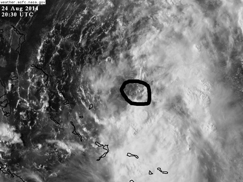
Cristobal is spinning nearly stationary N of the Turks and Caicos...
Carla/Alicia/Jerry(In The Eye)/Michelle/Charley/Ivan/Dennis/Katrina/Rita/Wilma/Humberto/Ike/Harvey
Member: National Weather Association
Facebook.com/Weather Infinity
Twitter @WeatherInfinity
Member: National Weather Association
Facebook.com/Weather Infinity
Twitter @WeatherInfinity