
December 2014: New Year's Eve Wintry Mix Possible
-
srainhoutx

- Site Admin

- Posts: 19616
- Joined: Tue Feb 02, 2010 2:32 pm
- Location: Maggie Valley, NC
- Contact:
The 12Z Euro suggests a power Winter storm wraps up across the Central/Southern Rockies into the Central Plains ushering in a very cold Arctic front on the 27th. That storm lifts NE into the Great Lakes and sets up a cross polar flow with an extremely -NAO/-AO as well as a -EPO Ridge off the West Coast building N. Cold air spills S from the Canadian Prairies into the Inter Mountain West and the Great Plains as we near New Years Eve. Note the shades of blue NE of Hawaii. That is the system that the parallel GFS blew up into a nasty storm over the Southern Rockies into Texas a couple of days after New Years Day. The Southern storm track looks rather impressive and consistent as well as additional moisture streaming in from the Eastern Pacific across Mexico and over our part of the World. We will see.
Carla/Alicia/Jerry(In The Eye)/Michelle/Charley/Ivan/Dennis/Katrina/Rita/Wilma/Humberto/Ike/Harvey
Member: National Weather Association
Facebook.com/Weather Infinity
Twitter @WeatherInfinity
Member: National Weather Association
Facebook.com/Weather Infinity
Twitter @WeatherInfinity
-
srainhoutx
- Site Admin
- Posts: 19616
- Joined: Tue Feb 02, 2010 2:32 pm
- Location: Maggie Valley, NC
- Contact:
The Updated CPC Day 11+ Analogs continue to advertise below normal temperatures and above normal precipitation as we end December and begin January 2015.
Carla/Alicia/Jerry(In The Eye)/Michelle/Charley/Ivan/Dennis/Katrina/Rita/Wilma/Humberto/Ike/Harvey
Member: National Weather Association
Facebook.com/Weather Infinity
Twitter @WeatherInfinity
Member: National Weather Association
Facebook.com/Weather Infinity
Twitter @WeatherInfinity
I am finally back in! Not that I post often.  I had forgotten my password and had a
  of a time getting it reset. It rained most of the day here in Stafford, a nice steady rain. Plants are happy, lawn is happy, we won't have to fill up the pond or the pool for a few days. Not looking forward to a warming trend, so will enjoy the cooler weather tomorrow and at month end if the models are correct.
-
brooksgarner

- Global Moderator

- Posts: 226
- Joined: Tue Jun 04, 2013 3:06 pm
- Location: Houston, TX
- Contact:
Glad the forum's back online! Thanks Steve, or letting me know it was down. We had some DNS issues with our Gannett servers, but it appears that everything is back online. I gave a shout-out on my Facebook page, so hopefully a few more folks check it out to see your discussions. Thanks!
Broadcast Met
http://BrooksGarner.com
http://twitter.com/BrooksWeather
http://BrooksGarner.com
http://twitter.com/BrooksWeather
- '17 Harvey
- '12 Sandy (P3 Orion)
- '91 Bob
- '85 Gloria


Quite a rainy day today. 
-
brooksgarner
- Global Moderator
- Posts: 226
- Joined: Tue Jun 04, 2013 3:06 pm
- Location: Houston, TX
- Contact:
A rare "soaker", indeed.
Broadcast Met
http://BrooksGarner.com
http://twitter.com/BrooksWeather
http://BrooksGarner.com
http://twitter.com/BrooksWeather
- '17 Harvey
- '12 Sandy (P3 Orion)
- '91 Bob
- '85 Gloria
1.56" was the total rainfall here. I spent the last part of today getting a new PWS mounted and reporting to wunderground.com.
http://www.wunderground.com/cgi-bin/fin ... .02,-95.40
http://www.wunderground.com/cgi-bin/fin ... .02,-95.40
-
srainhoutx
- Site Admin
- Posts: 19616
- Joined: Tue Feb 02, 2010 2:32 pm
- Location: Maggie Valley, NC
- Contact:
ronyan wrote:1.56" was the total rainfall here. I spent the last part of today getting a new PWS mounted and reporting to wunderground.com.
http://www.wunderground.com/cgi-bin/fin ... .02,-95.40
Very cool ronyan. I believe we a may have a couple of other members linked to wunderground.com...
Carla/Alicia/Jerry(In The Eye)/Michelle/Charley/Ivan/Dennis/Katrina/Rita/Wilma/Humberto/Ike/Harvey
Member: National Weather Association
Facebook.com/Weather Infinity
Twitter @WeatherInfinity
Member: National Weather Association
Facebook.com/Weather Infinity
Twitter @WeatherInfinity
-
srainhoutx
- Site Admin
- Posts: 19616
- Joined: Tue Feb 02, 2010 2:32 pm
- Location: Maggie Valley, NC
- Contact:
Interesting trends via the overnight GFS for most of Texas for New Years Eve into the first week of January.
Carla/Alicia/Jerry(In The Eye)/Michelle/Charley/Ivan/Dennis/Katrina/Rita/Wilma/Humberto/Ike/Harvey
Member: National Weather Association
Facebook.com/Weather Infinity
Twitter @WeatherInfinity
Member: National Weather Association
Facebook.com/Weather Infinity
Twitter @WeatherInfinity
can you explain what those trends are showing?
-
MontgomeryCoWx

- Posts: 2356
- Joined: Wed Dec 14, 2011 4:31 pm
- Location: Weimar, TX
- Contact:
Snow on NYE in Houston and on NYD
Team #NeverSummer

^^^what Ticka said!
-
srainhoutx
- Site Admin
- Posts: 19616
- Joined: Tue Feb 02, 2010 2:32 pm
- Location: Maggie Valley, NC
- Contact:
Looks like a progressive fast flow pattern with several disturbance crossing the Desert SW over the next several days into Christmas Eve when big full latitude trough across the Plains spins up a big storm that moves up into the Great Lake and then retrogrades W across Central Canada. This allows for a big plunge of much colder air to spill down the Canadian Prairies into the Inter Mountain West and all of the Plains with a strong Arctic front arriving on the 27th. Another shot of colder air drops S from Canada on the 29th and this may be a significant Arctic High pressure cell in the 1058 to 1060mb range. A big Southern tracking storm pushes E across the Eastern Pacific and tracks across Texas on New Years Eve after the cold arctic air has settled over our Region. A secondary storm arrives around the 4th of January bring additional moisture with another shot of cold air pushing S across the Plains. There are some indications a Coastal low wave may form with a very noisy sub tropical jet overhead. The longer range GEFS (ensembles) is suggesting we may stay cold to very cold during the first 7-9 days of January. Time will tell, but the various teleconnection indices agree that we are in for a potentially sustained period of much colder weather with an active Southern storm track which is typical of a weak El Nino pattern.ticka1 wrote:can you explain what those trends are showing?
Carla/Alicia/Jerry(In The Eye)/Michelle/Charley/Ivan/Dennis/Katrina/Rita/Wilma/Humberto/Ike/Harvey
Member: National Weather Association
Facebook.com/Weather Infinity
Twitter @WeatherInfinity
Member: National Weather Association
Facebook.com/Weather Infinity
Twitter @WeatherInfinity
-
Portastorm

- Posts: 800
- Joined: Wed Feb 03, 2010 3:04 pm
- Location: Southwest Austin/Oak Hill, TX
- Contact:
I sure did like the looks of that AUS meteogram!
Still a long ways out from a potential New Years Eve event for Austin/Houston and I noticed the European model is more transitory than the GFS with the nature of the cold airmass. Still, as srainhoutx suggests, the pattern looks fairly likely to get much colder and wetter after Christmas.
Still a long ways out from a potential New Years Eve event for Austin/Houston and I noticed the European model is more transitory than the GFS with the nature of the cold airmass. Still, as srainhoutx suggests, the pattern looks fairly likely to get much colder and wetter after Christmas.
The 0z Euro shows the initial front (27th-28th) as colder for TX, the GFS & PGFS depict this as a pretty mild front by late December standards but then the GFS brings a strong front through on the 30-31st. I'm looking forward to the return of winter in TX, here's to hoping some of these model runs showing winter weather hold up.
Hey folks, I know this is a Texas forum, so I beg your indulgence with a question concerning SE Louisiana. Srain, or someone, could you please extend your projections a little further to your neighbors to the east with this upcoming pattern change? I thank you in advance. 
-
brooksgarner
- Global Moderator
- Posts: 226
- Joined: Tue Jun 04, 2013 3:06 pm
- Location: Houston, TX
- Contact:
SO GLAD to be back on the forum... embarrassingly I'd lost my password/username and then got too busy with my young child and work to check in and participate.
On this last full day of autumn 2014: Just thinking out loud ...we (D.P. and I have been discussing winter...)
Drawing on some gut instinct for this season's winter, and his years of experience in SE TX: After November's "early" winter preview this 2014 -- with freeze warnings, etc -- I decided to go on Amazon to buy a new giant, analogue thermometer and laser gun temperature sensor (for pavement conditions), anticipating more wintry live reports this season compared to last winter.
Last winter, my dial thermometer was a bit old and probably off a few degrees, and the laser sensor was terribly inaccurate. Hopefully if I go out to cover another storm, the real-time data will be closer to reality. (I remember pointing my old pointer to the ground in Brenham and getting "-2ºF" on one reading and "44º on another..." Try explaining that on live TV... Whoops.
So, I may be eating crow after posting that I acted on my instincts for this winter, but January obviously looks interesting with the stratospheric warming anomaly in NE Asia potentially developing, leading to a jet amplification over CONUS, especially if we can get a few more big pacific storms to dig it down ... Certainly snow cover has been impressive across N. America this season compared to last -- and early! There's theoretically more resident cold air avail at lower latitudes.... there's a quazi-el nino or full on ENSO set up, establishing and maintaining active southern jet... If we can tap that cold air and get a few shots of moisture in here, we'll definitely get a few shots of ice and snow before the end of February... I recall last winter with an overall much less convincing pattern for a wintry setup, so maybe we'll be so lucky this year with measurable snow. (It'll be interesting to see if the spring severe setup is enhanced too, with the greater contrast in air masses. )
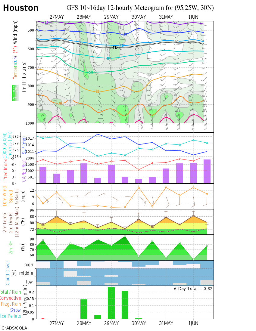
... data-wise, interesting to see the GFS meteogram persisting on a frigid start to 2015. http://wxmaps.org/pix/iahgfsb.png
On this last full day of autumn 2014: Just thinking out loud ...we (D.P. and I have been discussing winter...)
Drawing on some gut instinct for this season's winter, and his years of experience in SE TX: After November's "early" winter preview this 2014 -- with freeze warnings, etc -- I decided to go on Amazon to buy a new giant, analogue thermometer and laser gun temperature sensor (for pavement conditions), anticipating more wintry live reports this season compared to last winter.
Last winter, my dial thermometer was a bit old and probably off a few degrees, and the laser sensor was terribly inaccurate. Hopefully if I go out to cover another storm, the real-time data will be closer to reality. (I remember pointing my old pointer to the ground in Brenham and getting "-2ºF" on one reading and "44º on another..." Try explaining that on live TV... Whoops.
So, I may be eating crow after posting that I acted on my instincts for this winter, but January obviously looks interesting with the stratospheric warming anomaly in NE Asia potentially developing, leading to a jet amplification over CONUS, especially if we can get a few more big pacific storms to dig it down ... Certainly snow cover has been impressive across N. America this season compared to last -- and early! There's theoretically more resident cold air avail at lower latitudes.... there's a quazi-el nino or full on ENSO set up, establishing and maintaining active southern jet... If we can tap that cold air and get a few shots of moisture in here, we'll definitely get a few shots of ice and snow before the end of February... I recall last winter with an overall much less convincing pattern for a wintry setup, so maybe we'll be so lucky this year with measurable snow. (It'll be interesting to see if the spring severe setup is enhanced too, with the greater contrast in air masses. )
... data-wise, interesting to see the GFS meteogram persisting on a frigid start to 2015. http://wxmaps.org/pix/iahgfsb.png

I had 2.05" from the Thu-Fri storm. Looks like I will make it to Christmas with the garden still looking good, even the bananas/cannas, so I am very happy.
-
srainhoutx
- Site Admin
- Posts: 19616
- Joined: Tue Feb 02, 2010 2:32 pm
- Location: Maggie Valley, NC
- Contact:
harpman wrote:Hey folks, I know this is a Texas forum, so I beg your indulgence with a question concerning SE Louisiana. Srain, or someone, could you please extend your projections a little further to your neighbors to the east with this upcoming pattern change? I thank you in advance.
Hi harpman. Sorry I missed including our neighbors and longtime members from Louisiana this morning. I'll look at this after while and see if we can get some data up for you and all our followers beyond Texas. Remember, we've grown to a much more Regional Board over the years and folks follow us all across the Gulf Coast let alone from the Pacific Coast to the Atlantic Coast including the Caribbean Islands and Mexico. even The Weather Channel and CNN follow us these days and probably the Gannet Media stations as well.
Carla/Alicia/Jerry(In The Eye)/Michelle/Charley/Ivan/Dennis/Katrina/Rita/Wilma/Humberto/Ike/Harvey
Member: National Weather Association
Facebook.com/Weather Infinity
Twitter @WeatherInfinity
Member: National Weather Association
Facebook.com/Weather Infinity
Twitter @WeatherInfinity
Much appreciated, sir.
-
- Information
-
Who is online
Users browsing this forum: Ahrefs [Bot], Bing [Bot], TexasBreeze and 67 guests