2015 Eastern Pacific Tropical Weather Discussion

Tropical Weather Discussions and Analysis
User avatar
srainhoutx
Site Admin
Site Admin
Posts: 19616
Joined: Tue Feb 02, 2010 2:32 pm
Location: Maggie Valley, NC
Contact:

06092015 11AM PDT two_pac_5d0.png
TROPICAL WEATHER OUTLOOK
NWS NATIONAL HURRICANE CENTER MIAMI FL
1100 AM PDT TUE JUN 9 2015

For the eastern North Pacific...east of 140 degrees west longitude:

1. Showers and thunderstorms continue to show signs of organization in
association with an area of low pressure located several hundred
miles south of the Gulf of Tehuantepec. Environmental conditions
appear to be conducive for a tropical depression to form during the
next couple of days while this system moves slowly northwestward or
northward.
* Formation chance through 48 hours...medium...60 percent
* Formation chance through 5 days...high...90 percent

Forecaster Blake
Attachments
06092015_1715_goes13_x_vis2km_94EINVEST_25kts-1008mb-90N-960W_100pc.jpg
Carla/Alicia/Jerry(In The Eye)/Michelle/Charley/Ivan/Dennis/Katrina/Rita/Wilma/Humberto/Ike/Harvey

Member: National Weather Association
Facebook.com/Weather Infinity
Twitter @WeatherInfinity
User avatar
srainhoutx
Site Admin
Site Admin
Posts: 19616
Joined: Tue Feb 02, 2010 2:32 pm
Location: Maggie Valley, NC
Contact:

The National Hurricane Center has increased chances that 94E will develop into a tropical depression to 80% within the next 48 hours.

TROPICAL WEATHER OUTLOOK
NWS NATIONAL HURRICANE CENTER MIAMI FL
500 AM PDT WED JUN 10 2015

For the eastern North Pacific...east of 140 degrees west longitude:

1. Showers and thunderstorms associated with a low pressure area a
few hundred miles southwest of the Gulf of Tehuantepec have become
better organized since yesterday. Environmental conditions are
conducive for development, and a tropical depression is likely to
form later today or on Thursday while this system moves slowly
northwestward or northward.
* Formation chance through 48 hours...high...80 percent
* Formation chance through 5 days...high...90 percent

Forecaster Landsea
Attachments
06102015 5AM PDT two_pac_5d0.png
Carla/Alicia/Jerry(In The Eye)/Michelle/Charley/Ivan/Dennis/Katrina/Rita/Wilma/Humberto/Ike/Harvey

Member: National Weather Association
Facebook.com/Weather Infinity
Twitter @WeatherInfinity
User avatar
srainhoutx
Site Admin
Site Admin
Posts: 19616
Joined: Tue Feb 02, 2010 2:32 pm
Location: Maggie Valley, NC
Contact:

06102015_1330_goes13_x_vis2km_94EINVEST_25kts-1006mb-118N-975W_73pc.jpg
WEATHER RECONNAISSANCE FLIGHTS
CARCAH, NATIONAL HURRICANE CENTER, MIAMI, FL.
0935 AM EDT WED 10 JUNE 2015
SUBJECT: TROPICAL CYCLONE PLAN OF THE DAY (TCPOD)
VALID 11/1100Z TO 12/1100Z JUNE 2015
TCPOD NUMBER.....15-016

I. ATLANTIC REQUIREMENTS
1. NEGATIVE RECONNAISSANCE REQUIREMENTS.
2. OUTLOOK FOR SUCCEEDING DAY.....NEGATIVE.

II. PACIFIC REQUIREMENTS
1. NEGATIVE RECONNAISSANCE REQUIREMENTS.
2. SUCCEEDING DAY OUTLOOK: FIX A DEVELOPING SYSTEM AT
12/1730Z NEAR 15.0N 97.5W
Carla/Alicia/Jerry(In The Eye)/Michelle/Charley/Ivan/Dennis/Katrina/Rita/Wilma/Humberto/Ike/Harvey

Member: National Weather Association
Facebook.com/Weather Infinity
Twitter @WeatherInfinity
User avatar
srainhoutx
Site Admin
Site Admin
Posts: 19616
Joined: Tue Feb 02, 2010 2:32 pm
Location: Maggie Valley, NC
Contact:

Sure looks like a tropical cyclone has developed this afternoon SE of Acapulco.
Carla/Alicia/Jerry(In The Eye)/Michelle/Charley/Ivan/Dennis/Katrina/Rita/Wilma/Humberto/Ike/Harvey

Member: National Weather Association
Facebook.com/Weather Infinity
Twitter @WeatherInfinity
User avatar
srainhoutx
Site Admin
Site Admin
Posts: 19616
Joined: Tue Feb 02, 2010 2:32 pm
Location: Maggie Valley, NC
Contact:

TROPICAL DEPRESSION THREE-E DISCUSSION NUMBER 1
NWS NATIONAL HURRICANE CENTER MIAMI FL EP032015
400 PM CDT WED JUN 10 2015

Satellite imagery indicates that the deep convection associated
with the low pressure system located southwest of the Gulf of
Tehuantepec has become sufficiently well organized to designate the
formation of a tropical depression. Therefore, advisories are
being initiated at this time. The cyclone should remain in an
environment of low vertical shear and over warm waters for the next
several days, so steady strengthening seems to be a good bet. The
official wind speed forecast is generally above the intensity model
consensus. There is significant uncertainty in the longer range
intensity forecast, depending on how much the system interacts with
land.

Center fixes have had a fair amount of scatter, and my best
estimate of the initial motion is 315/8 kt. During the next 72
hours, the cyclone is likely to respond to a mid-level weakness over
the Gulf of Mexico by turning northward and north-northeastward.
Later in the forecast period, a mid-level ridge to the northwest is
expected to cause the system to turn toward the west-northwest and
move parallel the coast. The GFS model takes the system close to
the coast in 72 hours, but the ECMWF and GFDL model tracks keep the
cyclone offshore and are much farther to the west than the GFS
solution. As a compromise, the official track forecast is close
to the model consensus TVCN albeit not as far west as TVCN by 120
hours. Given the large divergence of the model tracks, this is a
low confidence forecast.

FORECAST POSITIONS AND MAX WINDS

INIT 10/2100Z 12.4N 98.7W 30 KT 35 MPH
12H 11/0600Z 13.0N 99.4W 35 KT 40 MPH
24H 11/1800Z 13.4N 99.9W 45 KT 50 MPH
36H 12/0600Z 14.0N 99.6W 55 KT 65 MPH
48H 12/1800Z 14.5N 99.2W 65 KT 75 MPH
72H 13/1800Z 15.5N 99.0W 70 KT 80 MPH
96H 14/1800Z 16.5N 100.5W 75 KT 85 MPH
120H 15/1800Z 17.5N 103.5W 75 KT 85 MPH

$$
Forecaster Pasch

Attachments
06102015 TD 3E 203724W5_NL_sm.gif
Carla/Alicia/Jerry(In The Eye)/Michelle/Charley/Ivan/Dennis/Katrina/Rita/Wilma/Humberto/Ike/Harvey

Member: National Weather Association
Facebook.com/Weather Infinity
Twitter @WeatherInfinity
ticka1
Posts: 1265
Joined: Wed Feb 03, 2010 3:02 pm
Location: Baytown/Mont Belvieu
Contact:

I don't see this crossing into the GOM instead it looks like it hugs the coastline in the Pacific. I know we will still get the moisture flow which is why our rain chances are increased for the weekend.
Paul Robison

ticka1 wrote:I don't see this crossing into the GOM instead it looks like it hugs the coastline in the Pacific. I know we will still get the moisture flow which is why our rain chances are increased for the weekend.

But perhaps not as much moisture for heavy rain as we would if it did actually cross into the Bay of Campeche/Gulf of Mexico.
User avatar
srainhoutx
Site Admin
Site Admin
Posts: 19616
Joined: Tue Feb 02, 2010 2:32 pm
Location: Maggie Valley, NC
Contact:

TROPICAL DEPRESSION THREE-E DISCUSSION NUMBER 3
NWS NATIONAL HURRICANE CENTER MIAMI FL EP032015
400 AM CDT THU JUN 11 2015


The depression does not appear to be strengthening yet. The
cyclone has a broad circulation with some evidence of multiple
centers. A pair of ASCAT passes at 0330 and 0415 UTC showed
maximum winds in the 25-30 kt range. Given that the convective
pattern has not changed much since the time of the ASCAT data, the
initial wind speed is kept at 30 kt. This intensity estimate is a
little lower than the Dvorak classifications from TAFB, SAB, and
UW-CIMSS ADT which are all T2.5/35 kt.

The initial motion estimate is an uncertain 305/7. The system is
expected to slow down and turn northward later today or tonight
when a mid- to upper-level trough over the Gulf of Mexico cuts off
and drifts westward. The low aloft is expected to weaken this
weekend, which should allow ridging to become better established to
the north of the tropical cyclone. This pattern change should
cause the system to turn west-northwestward and increase in
forward speed in a few days. Although a fair amount of spread still
exists in the model solutions, they have come into better agreement
compared to previous cycles. In fact, most of the guidance has
shifted south and west away from the coast of southern Mexico, and
the official track forecast follows that trend.

The depression is expected to remain over warm water and in a moist
airmass for the next several days. These conditions support
steady intensification. A slightly inhibiting factor is vertical
wind shear, which is forecast by the SHIPS model to be around 15
kt for the next few days. The official intensity forecast is just
an update of the previous one and shows gradual intensification
through the period. This forecast lies at the high end of the
guidance, in best agreement with the SHIPS model. It should be
noted that the future intensity of the system is dependent on how
much it interacts with land, so if the system gets closer to the
coast than predicted, the longer range part of the forecast could be
too high.


FORECAST POSITIONS AND MAX WINDS

INIT 11/0900Z 13.1N 100.2W 30 KT 35 MPH
12H 11/1800Z 13.5N 100.5W 40 KT 45 MPH
24H 12/0600Z 14.1N 100.6W 45 KT 50 MPH
36H 12/1800Z 14.4N 100.5W 55 KT 65 MPH
48H 13/0600Z 14.7N 100.4W 65 KT 75 MPH
72H 14/0600Z 15.5N 100.9W 70 KT 80 MPH
96H 15/0600Z 16.5N 103.4W 75 KT 85 MPH
120H 16/0600Z 17.5N 105.5W 80 KT 90 MPH

$$
Forecaster Cangialosi

Attachments
06112015 4AM CDT 083642W5_NL_sm.gif
06112015 TD 3E Winds 083642.gif
Carla/Alicia/Jerry(In The Eye)/Michelle/Charley/Ivan/Dennis/Katrina/Rita/Wilma/Humberto/Ike/Harvey

Member: National Weather Association
Facebook.com/Weather Infinity
Twitter @WeatherInfinity
User avatar
srainhoutx
Site Admin
Site Admin
Posts: 19616
Joined: Tue Feb 02, 2010 2:32 pm
Location: Maggie Valley, NC
Contact:

Tropical Storm Carlos has formed in the Eastern Pacific S of Acapulco. The official Advisory should be out with the 10 AM CDT Advisory Package.

Image
Attachments
06112015_1245_goes13_x_ir1km_03ETHREE_35kts-1001mb-133N-1004W_100pc.jpg
Carla/Alicia/Jerry(In The Eye)/Michelle/Charley/Ivan/Dennis/Katrina/Rita/Wilma/Humberto/Ike/Harvey

Member: National Weather Association
Facebook.com/Weather Infinity
Twitter @WeatherInfinity
User avatar
srainhoutx
Site Admin
Site Admin
Posts: 19616
Joined: Tue Feb 02, 2010 2:32 pm
Location: Maggie Valley, NC
Contact:

Tropical Storm Carlos forms 230 miles S of Acapulco.

TROPICAL STORM CARLOS DISCUSSION NUMBER 4
NWS NATIONAL HURRICANE CENTER MIAMI FL EP032015
1000 AM CDT THU JUN 11 2015

The organization of the tropical cyclone has gradually increased,
with a curved band of deep convection wrapping more than half way
around the system's center. The intensity is analyzed to be 35 kt
based upon a blend of TAFB, SAB, and ADT Dvorak estimates with
consideration that the pattern recognition methods were apparently
a bit biased high in comparison with the ASCAT scatterometer
winds overnight. Thus the system is upgraded to Carlos, the third
tropical storm of the season in the Eastern North Pacific.

Even though the cyclone is over very warm waters, Carlos is likely
to continue to intensify at a moderate pace due to about 15 kt of
northeasterly vertical shear expected during the next two to three
days. At the longer forecast times, the shear may decrease as
Carlos approaches the axis of the upper-tropospheric ridge.
However, a dry and more stable environment at that time may preclude
substantial intensification. Given that Carlos' track now is
projected to remain away from the Mexican coast for at least
the short-term, it is less likely that land influences will affect
the system. The official intensity forecast is based upon a blend
of the LGEM and SHIPS statistical-dynamical models and is slightly
lower than that from the previous advisory.

Carlos is moving toward the northwest at about 5 kt. Shortly, a
developing trough over the Gulf of Mexico will cause the steering
pattern to weaken and Carlos should meander northward for the
next couple of days. In three to four days, a deep-layered ridge
will become re-established north of Carlos and help propel it
northwest or west-northwestward at a slow forward speed,
paralleling the southwestern Mexican coast. The official track
prediction is based upon the TVCN multi-model track consensus and
is just slightly southwest of that from the previous advisory.

FORECAST POSITIONS AND MAX WINDS

INIT 11/1500Z 13.6N 100.4W 35 KT 40 MPH
12H 12/0000Z 14.0N 100.7W 45 KT 50 MPH
24H 12/1200Z 14.2N 100.8W 50 KT 60 MPH
36H 13/0000Z 14.4N 100.7W 60 KT 70 MPH
48H 13/1200Z 14.7N 100.7W 65 KT 75 MPH
72H 14/1200Z 15.6N 101.7W 70 KT 80 MPH
96H 15/1200Z 16.8N 104.1W 70 KT 80 MPH
120H 16/1200Z 17.7N 106.4W 75 KT 85 MPH

$$
Forecaster Landsea
06112015 8AM PDT 144246W5_NL_sm.gif
Attachments
06112015_1430_goes13_x_vis2km_03ETHREE_35kts-1001mb-133N-1004W_73pc.jpg
Carla/Alicia/Jerry(In The Eye)/Michelle/Charley/Ivan/Dennis/Katrina/Rita/Wilma/Humberto/Ike/Harvey

Member: National Weather Association
Facebook.com/Weather Infinity
Twitter @WeatherInfinity
User avatar
srainhoutx
Site Admin
Site Admin
Posts: 19616
Joined: Tue Feb 02, 2010 2:32 pm
Location: Maggie Valley, NC
Contact:

BULLETIN
TROPICAL STORM CARLOS INTERMEDIATE ADVISORY NUMBER 7A
NWS NATIONAL HURRICANE CENTER MIAMI FL EP032015
700 AM CDT FRI JUN 12 2015

...CARLOS STATIONARY SOUTH OF MEXICO...


SUMMARY OF 700 AM CDT...1200 UTC...INFORMATION
----------------------------------------------
LOCATION...14.7N 100.8W
ABOUT 165 MI...265 KM SSW OF ACAPULCO MEXICO
ABOUT 215 MI...345 KM SSE OF ZIHUATANEJO MEXICO
MAXIMUM SUSTAINED WINDS...60 MPH...95 KM/H
PRESENT MOVEMENT...STATIONARY
MINIMUM CENTRAL PRESSURE...997 MB...29.44 INCHES


WATCHES AND WARNINGS
--------------------
CHANGES WITH THIS ADVISORY:

None.

SUMMARY OF WATCHES AND WARNINGS IN EFFECT:

A Tropical Storm Watch is in effect for...
* Acapulco to Zihuatanejo

A Tropical Storm Watch means that tropical storm conditions are
possible within the watch area, generally within 48 hours.

For storm information specific to your area, please monitor
products issued by your national meteorological service.


DISCUSSION AND 48-HOUR OUTLOOK
------------------------------
At 700 AM CDT (1200 UTC), the center of Tropical Storm Carlos was
located near latitude 14.7 North, longitude 100.8 West. Carlos is
currently stationary, and only a slow movement to the northwest is
expected over the next couple of days.

Maximum sustained winds remain near 60 mph (95 km/h) with higher
gusts. Some strengthening is expected, and Carlos is forecast to
become a hurricane on Saturday.

Tropical storm force winds extend outward up to 80 miles (130 km)
from the center.

The estimated minimum central pressure is 997 mb (29.44 inches).


HAZARDS AFFECTING LAND
----------------------
WIND: Tropical storm conditions are possible within the watch area
by Saturday night.

RAINFALL: Locally heavy rains could spread over portions of the
southern coast of Mexico, primarily in the states of Oaxaca and
Guerrero, during the next couple of days.

SURF: Swells associated with Carlos are expected to increase near
the coast of southern Mexico during the next few days. These swells
could cause life-threatening surf and rip current conditions.
Please consult products from your local weather office.


NEXT ADVISORY
-------------
Next complete advisory at 1000 AM CDT.
Attachments
06122015_1300_goes13_x_vis2km_03ECARLOS_50kts-997mb-147N-1007W_77pc.jpg
Carla/Alicia/Jerry(In The Eye)/Michelle/Charley/Ivan/Dennis/Katrina/Rita/Wilma/Humberto/Ike/Harvey

Member: National Weather Association
Facebook.com/Weather Infinity
Twitter @WeatherInfinity
unome
Posts: 3059
Joined: Fri Feb 12, 2010 6:11 pm

it snuck up while distracted with 91L http://www.nhc.noaa.gov/#CARLOS

ZCZC MIATCDEP3 ALL
TTAA00 KNHC DDHHMM

HURRICANE CARLOS DISCUSSION NUMBER 12
NWS NATIONAL HURRICANE CENTER MIAMI FL EP032015
1000 AM CDT SAT JUN 13 2015

Satellite data indicate that Carlos has strengthened with a ragged
eye becoming apparent on the latest visible imagery. In addition,
radar data from Acapulco show that an eyewall has become
established, although it is still open on the north side. Dvorak
estimates from TAFB/SAB are 65 kt, so this will be the initial
intensity.

After an eastward jog overnight, Carlos appears to have resumed a
northwestward drift. For the rest of the weekend, a building ridge
over Mexico is expected to steer Carlos generally to the
west-northwest. Thereafter, a mid-level trough near the Baja
California peninsula should cause Carlos to turn northwestward.
However, the hurricane is now farther to the east than expected
yesterday, which has moved the track closer to the southwestern
coast of Mexico. Track guidance has been steadily shifting
eastward, and a few models are now showing landfall in Mexico. While
I am not yet ready to show that solution, the NHC prediction has
been shifted eastward to account for the greater threat to Mexico.

Accordingly, the government of Mexico has issued a tropical storm
warning and hurricane watch for a portion of the southwestern coast.

Since Carlos is expected to remain over very warm water with
decreasing shear, it seems likely that further intensification will
occur over the next day or so. However, there is very poor
agreement on what will occur after that time due to competing
atmospheric factors and possible land interaction. The new NHC
forecast stays on the upper end of the guidance and is raised from
the previous one. It is worth noting that the normally
conservative HWRF is above the latest NHC prediction.


With Carlos becoming a hurricane, this is the second earliest on
record that the third hurricane has occurred in the eastern
Pacific season, one day behind the third hurricane of 1956.


FORECAST POSITIONS AND MAX WINDS

INIT 13/1500Z 14.9N 100.2W 65 KT 75 MPH
12H 14/0000Z 15.2N 100.5W 70 KT 80 MPH
24H 14/1200Z 15.8N 101.3W 75 KT 85 MPH
36H 15/0000Z 16.3N 102.2W 75 KT 85 MPH
48H 15/1200Z 16.9N 103.1W 70 KT 80 MPH
72H 16/1200Z 18.6N 105.0W 65 KT 75 MPH
96H 17/1200Z 20.5N 106.2W 50 KT 60 MPH
120H 18/1200Z 22.5N 107.5W 40 KT 45 MPH

$$
Forecaster Blake

NNNN

Image
unome
Posts: 3059
Joined: Fri Feb 12, 2010 6:11 pm

http://www.nhc.noaa.gov/#CARLOS

...CARLOS WEAKENS TO A TROPICAL STORM JUST SOUTH OF MEXICO... ...EXPECTED TO RESTRENGTHEN INTO A HURRICANE BY MONDAY...

10:00 AM CDT Sun Jun 14
Location: 15.9°N 100.4°W
Moving: NW at 2 mph
Min pressure: 986 mb
Max sustained: 70 mph


000
WTPZ33 KNHC 141449
TCPEP3

BULLETIN
TROPICAL STORM CARLOS ADVISORY NUMBER 16
NWS NATIONAL HURRICANE CENTER MIAMI FL EP032015
1000 AM CDT SUN JUN 14 2015

...CARLOS WEAKENS TO A TROPICAL STORM JUST SOUTH OF MEXICO...
...EXPECTED TO RESTRENGTHEN INTO A HURRICANE BY MONDAY...


SUMMARY OF 1000 AM CDT...1500 UTC...INFORMATION
-----------------------------------------------
LOCATION...15.9N 100.4W
ABOUT 75 MI...125 KM SSW OF ACAPULCO MEXICO
ABOUT 190 MI...300 KM SE OF LAZARO CARDENAS MEXICO
MAXIMUM SUSTAINED WINDS...70 MPH...110 KM/H
PRESENT MOVEMENT...NW OR 320 DEGREES AT 2 MPH...4 KM/H
MINIMUM CENTRAL PRESSURE...986 MB...29.12 INCHES


WATCHES AND WARNINGS
--------------------
CHANGES WITH THIS ADVISORY:

The Government of Mexico has discontinued the Tropical Storm Warning
east of Acapulco.

SUMMARY OF WATCHES AND WARNINGS IN EFFECT:

A Hurricane Warning is in effect for...
* Punta San Telmo to Tecpan de Galeana

A Hurricane Watch is in effect for...
* West of Punta San Telmo to Manzanillo

A Tropical Storm Warning is in effect for...
* East of Tecpan de Galeana to Acapulco

A Hurricane Warning means that hurricane conditions are expected
somewhere within the warning area. A warning is typically issued
36 hours before the anticipated first occurrence of
tropical-storm-force winds, conditions that make outside
preparations difficult or dangerous. Preparations to protect life
and property should be rushed to completion.

A Hurricane Watch means that hurricane conditions are possible
somewhere within the watch area within 48 hours.

A Tropical Storm Warning means that tropical storm conditions are
expected somewhere within the warning area, in this case within
the next 12 to 24 hours.

Interests elsewhere along the southwest coast of Mexico should
monitor the progress of Carlos.

For storm information specific to your area, please monitor
products issued by your national meteorological service.


DISCUSSION AND 48-HOUR OUTLOOK
------------------------------
At 1000 AM CDT (1500 UTC), the center of Tropical Storm Carlos was
located near latitude 15.9 North, longitude 100.4 West. Carlos is
moving toward the northwest near 2 mph (4 km/h) and this general
motion is expected to continue through Monday. A turn toward the
west-northwest with some increase in forward speed is expected over
the next couple of days.

Maximum sustained winds have decreased to near 70 mph (110 km/h)
with higher gusts. However, some restrengthening is forecast during
the next 48 hours, and Carlos is expected to become a hurricane
again by Monday.

Tropical-storm-force winds extend outward up to 70 miles (110 km)
from the center.

The estimated minimum central pressure is 986 mb (29.12 inches).


HAZARDS AFFECTING LAND
----------------------
WIND: Tropical storm conditions are expected within the tropical
storm warning area today, and Acapulco recently reported a gust to
43 mph (69 km/h). Hurricane conditions are expected to begin within
the hurricane warning area on Monday. Hurricane conditions are
possible within the hurricane watch area Monday night or early
Tuesday.

RAINFALL: Carlos is expected to produce rains in the Mexican states
of Oaxaca, Guerrero, Michoacan, Colima and Jalisco, with rainfall
accumulations of 6 to 10 inches possible through Tuesday with
maximum totals of 15 inches possible. These rains may produce
life-threatening flash floods and mud slides, especially in areas of
higher terrain.

SURF: Swells associated with Carlos will affect the coasts of
southern and southwestern Mexico during the next few days. These
swells could cause life-threatening surf and rip currents. Please
consult products from your local weather office.


NEXT ADVISORY
-------------
Next intermediate advisory at 100 PM CDT.
Next complete advisory at 400 PM CDT.

$$
Forecaster Stewart
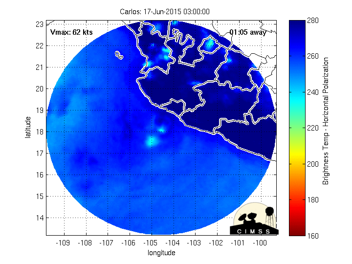
carlos wind history.gif
unome
Posts: 3059
Joined: Fri Feb 12, 2010 6:11 pm

http://www.nhc.noaa.gov/#CARLOS
083627W5_NL_sm.gif
000
WTPZ33 KNHC 150836
TCPEP3

BULLETIN
TROPICAL STORM CARLOS ADVISORY NUMBER 19
NWS NATIONAL HURRICANE CENTER MIAMI FL EP032015
400 AM CDT MON JUN 15 2015

...CARLOS STILL A TROPICAL STORM...


SUMMARY OF 400 AM CDT...0900 UTC...INFORMATION
----------------------------------------------
LOCATION...16.7N 101.8W
ABOUT 125 MI...205 KM W OF ACAPULCO MEXICO
ABOUT 95 MI...150 KM SSE OF LAZARO CARDENAS MEXICO
MAXIMUM SUSTAINED WINDS...70 MPH...110 KM/H
PRESENT MOVEMENT...WNW OR 295 DEGREES AT 6 MPH...9 KM/H
MINIMUM CENTRAL PRESSURE...988 MB...29.18 INCHES


WATCHES AND WARNINGS
--------------------
CHANGES WITH THIS ADVISORY:

None.

SUMMARY OF WATCHES AND WARNINGS IN EFFECT:

A Hurricane Warning is in effect for...
* Punta San Telmo to Tecpan de Galeana

A Hurricane Watch is in effect for...
* West of Punta San Telmo to Playa Perula

Interests elsewhere along the southwest coast of Mexico should
monitor the progress of Carlos.

For storm information specific to your area, please monitor
products issued by your national meteorological service.


DISCUSSION AND 48-HOUR OUTLOOK
------------------------------
At 400 AM CDT (0900 UTC), the center of Tropical Storm Carlos was
located near latitude 16.7 North, longitude 101.8 West. Carlos is
moving toward the west-northwest near 6 mph (9 km/h). This
general motion is expected to continue through Tuesday, followed
by a turn toward the northwest on Wednesday. On the forecast track,
Carlos will move parallel to the southern coast of Mexico over the
next day or two. However, a small deviation to the north of the
track would bring the center of Carlos closer to the coast.

Maximum sustained winds remain near 70 mph (110 km/h) with higher
gusts. Some strengthening is expected during the next 24 hours and
Carlos is forecast to become a hurricane again by early Tuesday.

Carlos is small cyclone. Tropical-storm-force winds extend outward
up to 45 miles (75 km) from the center.

The estimated minimum central pressure is 988 mb (29.18 inches).


HAZARDS AFFECTING LAND
----------------------
WIND: Hurricane conditions are expected to begin within the
hurricane warning area today. Hurricane conditions are possible
within the hurricane watch area tonight or early Tuesday.

RAINFALL: Carlos is expected to produce rains in the Mexican states
of Guerrero, Michoacan, Colima, Jalisco and Nayarit, with rainfall
accumulations of 6 to 10 inches possible through Wednesday, and
maximum totals of 15 inches possible. These rains may produce life-
threatening flash floods and mud slides, especially in areas of
higher terrain.

SURF: Swells associated with Carlos will affect the coasts of
southern and southwestern Mexico during the next few days. These
swells could cause life-threatening surf and rip currents. Please
consult products from your local weather office.


NEXT ADVISORY
-------------
Next intermediate advisory at 700 AM CDT.
Next complete advisory at 1000 AM CDT.

$$
Forecaster Roberts
User avatar
srainhoutx
Site Admin
Site Admin
Posts: 19616
Joined: Tue Feb 02, 2010 2:32 pm
Location: Maggie Valley, NC
Contact:

A very strong WWB (Westerly Wind Burst) associated with a very strong MJO pulse continues to migrate E toward the Eastern Pacific Ocean. To the West across the Western Pacific no less than 4 tropical cyclones are developing (3 North of the equator and 1 South of the equator) due to the strong MJO among other factors and the Global guidance is beginning to indicate at least 3 possible tropical cyclones may develop SE and E of Hawaii and offshore of Mexico as the MJO pulse migrates closer to the Western Atlantic Basin. Hopefully all this tropical troubles clears up over the next 45 days as I am due to depart for Hawaii around mid August for a week of much needed R and R on Waikiki Beach. Off course Rick Knabb and Bill Read were kidding me at the Houston/Galveston Hurricane Workshop that I may have a front row seat since the Central Pacific is expected to see above average activity this season... ;)

Image

Image

Image

Image

TROPICAL WEATHER OUTLOOK
NWS NATIONAL HURRICANE CENTER MIAMI FL
500 AM PDT THU JUL 2 2015

For the eastern North Pacific...east of 140 degrees west longitude:

1. An area of disturbed weather has formed about 1700 miles
east-southeast of the Hawaiian Islands. Environmental conditions
are forecast to become conducive for gradual development of this
system over the next several days while it moves slowly
west-northwestward.
* Formation chance through 48 hours...low...near 20 percent
* Formation chance through 5 days...medium...50 percent

Forecaster Brown
Carla/Alicia/Jerry(In The Eye)/Michelle/Charley/Ivan/Dennis/Katrina/Rita/Wilma/Humberto/Ike/Harvey

Member: National Weather Association
Facebook.com/Weather Infinity
Twitter @WeatherInfinity
User avatar
srainhoutx
Site Admin
Site Admin
Posts: 19616
Joined: Tue Feb 02, 2010 2:32 pm
Location: Maggie Valley, NC
Contact:

EPAC INVEST 91L continues to organize this afternoon and could pose a threat to Hawaii in about a week. If the westward motion continues and the threat to Hawaii increases, the 53rd Weather Reconnaissance Squadron (Hurricane Hunters) make begin transitioning a C-130 from Biloxi to Hickam Field in Pearl Harbor to investigate this weekend.

Image
07292015 18Z 91E_tracks_18z.png
07292015 18Z 91E_intensity_18z.png
Carla/Alicia/Jerry(In The Eye)/Michelle/Charley/Ivan/Dennis/Katrina/Rita/Wilma/Humberto/Ike/Harvey

Member: National Weather Association
Facebook.com/Weather Infinity
Twitter @WeatherInfinity
User avatar
srainhoutx
Site Admin
Site Admin
Posts: 19616
Joined: Tue Feb 02, 2010 2:32 pm
Location: Maggie Valley, NC
Contact:

I've been watching this little disturbance for about the past week which had some model support of becoming the next possible threat to Hawaii as it churns W across the Eastern Pacific. 93E lost all model support for developing into a tropical cyclone but continues fight the odds of a lot of dry air and wind shear as convection is still developing within a modest Convectively Coupled Kelvin Wave and raising air associated with a bit of a wet phase MJO pulse. I'll be watching this disturbance a bit more closely to see if it has a trick or two up its sleeve and interferes with my trip to Hawaii next week.
Attachments
08112015_1530_goes15_x_vis1km_high_93EINVEST_30kts-1009mb-166N-1304W_100pc.jpg
Carla/Alicia/Jerry(In The Eye)/Michelle/Charley/Ivan/Dennis/Katrina/Rita/Wilma/Humberto/Ike/Harvey

Member: National Weather Association
Facebook.com/Weather Infinity
Twitter @WeatherInfinity
User avatar
srainhoutx
Site Admin
Site Admin
Posts: 19616
Joined: Tue Feb 02, 2010 2:32 pm
Location: Maggie Valley, NC
Contact:

TROPICAL WEATHER OUTLOOK
NWS NATIONAL HURRICANE CENTER MIAMI FL
1100 AM PDT TUE AUG 11 2015

For the eastern North Pacific...east of 140 degrees west longitude:

1. Shower and thunderstorm activity has become better organized this
morning in association with an area of low pressure located about
1400 miles west-southwest of the southern tip of the Baja California
peninsula. While environmental conditions are expected to become
increasingly unfavorable for development, this system could become a
tropical depression later today or tonight while it moves westward
at around 10 mph.
* Formation chance through 48 hours...medium...50 percent
* Formation chance through 5 days...medium...50 percent

2. A tropical wave located south of the coast of Guatemala and El
Salvador is producing an area of disorganized cloudiness and
showers. An area of low pressure is forecast to form in association
with this wave a few hundred miles south-southwest of the coast of
Mexico later this week. Environmental conditions should support
gradual development of the low by the weekend while it moves
west-northwestward at about 15 mph.
* Formation chance through 48 hours...low...10 percent
* Formation chance through 5 days...high...70 percent

Forecaster Brennan
Carla/Alicia/Jerry(In The Eye)/Michelle/Charley/Ivan/Dennis/Katrina/Rita/Wilma/Humberto/Ike/Harvey

Member: National Weather Association
Facebook.com/Weather Infinity
Twitter @WeatherInfinity
Post Reply
  • Information
  • Who is online

    Users browsing this forum: Semrush [Bot] and 61 guests