As most of you know I begin my journey to Oahu/Hawaii tomorrow morning. Kiddingly Dr. Rick Knabb (National Hurricane Center Director) and Bill Read (Former National Hurricane Center Director) told me back in June at the Houston/Galveston Hurricane Workshop I would probably experience a Hurricane while on my trip since the Eastern and Central Pacific tends to see above normal tropical cyclone activity during an developing El Nino. Well, once again the Hawaiian Islands may see a tropical cyclone pose a threat this weekend into early next week while I am there. The Central Pacific Hurricane Center is monitoring an area of disturbed weather SE of Hawaii. The computer models have been 'sniffing' the potential of a tropical cyclone organizing this week with the GFS bringing a possible landfall into the heart of the Island Chain early next Monday. The European has also began aggressive developing a tropical cyclone but so far keeps the system S of the Islands. Should this pose a threat to Hawaii, I will be providing updates in this thread and wxman57 is also monitoring the possible developments...just in case. Remember that the Hawaiian Islands are just a small dot in the Central Pacific and Hawaii has not experienced a direct hit in many years. Hurricane Iniki in 1992 was the strongest Hurricane to impact the Hawaiian Islands and left significant damage. Fingers crossed Hawaii will continue being protected from a land falling Hurricane.
TROPICAL WEATHER OUTLOOK
NWS CENTRAL PACIFIC HURRICANE CENTER HONOLULU HI
200 AM HST MON AUG 17 2015
For the central north Pacific, between 140°W and 180.
1. Showers and thunderstorms associated with a broad area of low pressure located about 1200 miles southeast of Hilo, Hawaii remain disorganized. Environmental conditions will support some gradual development and organization over the next couple of days as the low remains nearly stationary.
* Formation chance through 48 hours, low, 10 percent.
Elsewhere, no tropical cyclones are expected through late Tuesday night.
The attachment 08172015 2 AM HST gtwo_gsat.gif is no longer available
Carla/Alicia/Jerry(In The Eye)/Michelle/Charley/Ivan/Dennis/Katrina/Rita/Wilma/Humberto/Ike/Harvey
Member: National Weather Association
Facebook.com/Weather Infinity
Twitter @WeatherInfinity
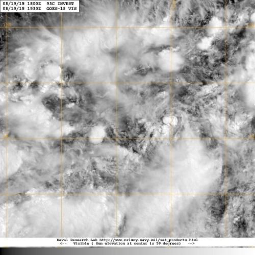
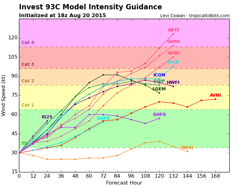
93C about 850 miles SE of Hilo continues to fester embedded within the ITCZ this morning. The Central Pacific Hurricane Center is giving this disturbance a 50% chance of developing into a tropical cyclone. There is a growing potential that the Hurricane Hunters will be transitioning back to Hawaii as the various computer models are suggesting a possible threat to Hawaii during this coming weekend into early next week. What makes this disturbance a bit more concerning is the track which would bring the potential cyclone from S to N versus what we have seen with Guillermo and Hilda which moved from E to W toward the Big Island. Typically the storms that have impacted Hawaii directly and the strongest have been traveling from S to N and impacted the Island Chain. The latest intensity guidance suggests a Category 1 and possibly a low end Category 2 could possibly develop. I will continue to provide updates once I arrive in Honolulu this afternoon, Hawaii Standard Time.
Carla/Alicia/Jerry(In The Eye)/Michelle/Charley/Ivan/Dennis/Katrina/Rita/Wilma/Humberto/Ike/Harvey
Member: National Weather Association
Facebook.com/Weather Infinity
Twitter @WeatherInfinity
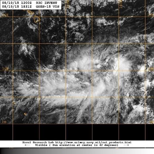
Greeting from Waikiki Beach. It appears that 93C has remained stationary today during my 8 hour flight to Honolulu SE of Hilo, but is showing signs of organizing. I have received information that a Squadron of the 53rd Weather Reconnaissance out of Biloxi will begin to transition to Hickam Field here in Pearl Harbor tomorrow to begin sampling what looks to be another possible threat to the Hawaiian Islands later this weekend/early next week.
Attachments
Carla/Alicia/Jerry(In The Eye)/Michelle/Charley/Ivan/Dennis/Katrina/Rita/Wilma/Humberto/Ike/Harvey
Member: National Weather Association
Facebook.com/Weather Infinity
Twitter @WeatherInfinity
Aloha from Waikiki Beach/Oahu. The 53rd Weather Reconnaissance Squadron will arrive at Hickam Field tomorrow and begin 12 hourly missions to 93C (potential Kilo) tomorrow evening/early Friday morning. Currently Flash Flood Watches are hoisted for all of the Hawaiian Islands mainly due to the upper low N of Hawaii pulling in abundant tropical moisture from the south across the Island Chain. Several inches of rainfall is expected across the higher terrain the next day or two. The weekend forecast currently calls for increasing rain and winds with higher waves along the South and SE facing beaches of the Hawaiian Island Chain depending on the eventual track of the developing Tropical Cyclone to the SSE of Hawaii.
Carla/Alicia/Jerry(In The Eye)/Michelle/Charley/Ivan/Dennis/Katrina/Rita/Wilma/Humberto/Ike/Harvey
Member: National Weather Association
Facebook.com/Weather Infinity
Twitter @WeatherInfinity
WEATHER RECONNAISSANCE FLIGHTS
CARCAH, NATIONAL HURRICANE CENTER, MIAMI, FL.
1030 AM EDT WED 19 AUGUST 2015
SUBJECT: TROPICAL CYCLONE PLAN OF THE DAY (TCPOD)
         VALID 20/1100Z TO 21/1100Z AUGUST 2015
         TCPOD NUMBER.....15-085
.

II. PACIFIC REQUIREMENTS
    1. NEGATIVE RECONNAISSANCE REQUIREMENTS.
    2. SUCCEEDING DAY OUTLOOK: FIX A DEVELOPING SYSTEM SOUTH OF
       THE HAWAIIAN ISLANDS NEAR 13.8N 151.4W AT 21/1800Z AND
       NEAR 14.8N 154.0W AT 22/0600Z.
$$
JWP
Carla/Alicia/Jerry(In The Eye)/Michelle/Charley/Ivan/Dennis/Katrina/Rita/Wilma/Humberto/Ike/Harvey
Member: National Weather Association
Facebook.com/Weather Infinity
Twitter @WeatherInfinity
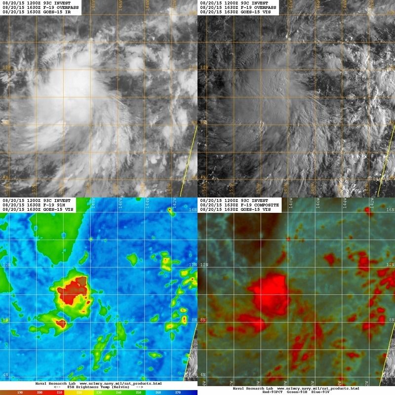
Aloha from a breezy and cloudy Honolulu. 93C continues to organize and a low level circulation is very evident via satellite imagery. The Hurricane Hunter C-130 is about to depart from Travis AFB in California for the flight over to Hickam Field/Pearl Harbor. I will be meeting up with the crew this afternoon for dinner before missions begin Friday to investigate 93C ( likely TD or TS Kilo ). The HPC/WPC Hawaiian Message is not encouraging for the Hawaiian Island Chain for the next week or so...
Hawaii Extended Forecast Discussion
NWS Weather Prediction Center College Park MD
817 AM EDT Thu Aug 20 2015
Valid 00Z Fri Aug 21 2015 - 00Z Fri Aug 28 2015
...The Tropics Threaten Once Again...
The models indicate that Hawai'i will continue to remain
vulnerable to disturbances in the trades for the foreseeable
future. A couple of these disturbances--the one about 1,000 miles
south-southeast of the state and another that the 00Z/20 ECMWF
seems to like a week from now--have the potential to develop into
tropical cyclones. Many of the GFS solutions of late, including
the 06Z/20 run, recurve the first low into Hawai'i with a rather
menacing intensification Monday and Tuesday. Even without any
"formal" tropical cyclone, the pattern looks as unsettled and
unpredictable as it has been most of the past month or more.
Five-day QPF through 00Z/26 Wednesday is in excess of
three-quarters of an inch everywhere, with much higher amounts in
the terrain. Any near- or direct-hit from a tropical cyclone could
produce totals in the feet.
Cisco
Attachments
Carla/Alicia/Jerry(In The Eye)/Michelle/Charley/Ivan/Dennis/Katrina/Rita/Wilma/Humberto/Ike/Harvey
Member: National Weather Association
Facebook.com/Weather Infinity
Twitter @WeatherInfinity
Tropical Depression 3 C forms in the Central Pacific approximately 900 miles SSE of Honolulu. The Central Pacific Hurricane Center will begin issuing Advisories shortly for this developing Tropical Cyclone.
Attachments
Carla/Alicia/Jerry(In The Eye)/Michelle/Charley/Ivan/Dennis/Katrina/Rita/Wilma/Humberto/Ike/Harvey
Member: National Weather Association
Facebook.com/Weather Infinity
Twitter @WeatherInfinity
TROPICAL DEPRESSION THREE-C DISCUSSION NUMBER 1
NWS CENTRAL PACIFIC HURRICANE CENTER HONOLULU HI CP032015
1100 AM HST THU AUG 20 2015
SATELLITE IMAGERY SHOWED THAT A TROPICAL DISTURBANCE SOUTHEAST OF
THE MAIN HAWAIIAN ISLANDS HAS DEVELOPED SUFFICIENT PERSISTENT DEEP
CONVECTION AROUND A CLOSED CIRCULATION TO BE CONSIDERED A TROPICAL
DEPRESSION. THEREFORE...ADVISORIES ARE BEING INITIATED ON TROPICAL
DEPRESSION THREE-C. THIS IS THE SIXTH TROPICAL CYCLONE IN THE
CENTRAL NORTH PACIFIC BASIN FOR THE 2015 SEASON. DVORAK INTENSITY
ESTIMATES FROM THE FIX AGENCIES CAME IN AT 30 KT FROM PHFO AND
SAB...AND 25 KT FROM JTWC. THE INITIAL INTENSITY WILL BE 30 KT FOR
THIS FORECAST PACKAGE.
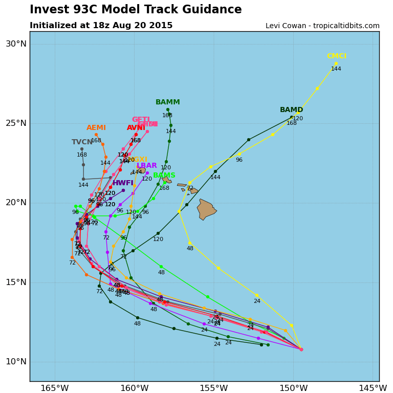
THE DEPRESSION IS MOVING AT 280/14 KT. THE LOW CONFIDENCE OF THE
CENTER POSITIONS OVER THE PAST 12 TO 24 HOURS MAKES THIS MOVEMENT
UNCERTAIN. OBJECTIVE AIDS ARE TIGHTLY LINED UP WITH A GENERAL
WEST TO WEST-NORTHWEST MOTION THROUGH TWO DAYS AS THREE-C MOVES
SOUTH OF A MID-LEVEL RIDGE BUILDING WESTWARD. IN ABOUT THREE DAYS...
A WEAKNESS IS FORECAST TO DEVELOP IN THE RIDGE WHICH WOULD RESULT IN
A SLOWING OF FORWARD MOTION AND A GRADUAL TURN TOWARD THE NORTH OR
NORTH-NORTHEAST. THE MAIN DYNAMICAL AIDS DIFFER ON THE LOCATION OF
THE TURN WITH THE HWRF AND GFS ON THE EAST SIDE OF THE ENVELOPE AND
THE ECMWF ON THE WEST SIDE. THE TIMING OF THE TURN WILL DEPEND
GREATLY ON WHEN THE WEAKNESS IN THE RIDGE OCCURS. THE LONGER IT
TAKES...THE FARTHER WEST THE CYCLONE WILL MOVE BEFORE MAKING THE
TURN AND THIS ASPECT OF THE FORECAST CONTAINS A HIGH AMOUNT OF
UNCERTAINTY. THE FORECAST CLOSELY FOLLOWS THE DYNAMIC CONSENSUS
THROUGH THE PACKAGE WITH THE TROPICAL CYCLONE APPROACHING
THE WEST SIDE OF THE MAIN HAWAIIAN ISLANDS IN FIVE DAYS.
TROPICAL DEPRESSION THREE-C IS MOVING OVER VERY WARM WATER...OVER
29C...BASED ON THE LATEST ANALYSIS. THERE APPEARS TO BE SOME
EASTERLY SHEAR IMPACTING THE SYSTEM BASED ON THE FLATTENING OF THE
HIGH LEVEL CLOUDS ON THE EAST SIDE AND THE CIMSS 1800 UTC SHEAR
ANALYSIS SHOWING MORE THAN 20 KT. THIS SHEAR IS FORECAST TO STEADILY
DECREASE OVER THE NEXT TWO TO THREE DAYS AS THE DEPRESSION MOVES
UNDERNEATH THE UPPER LEVEL RIDGE AXIS. THE WEAKENING SHEAR AND
THE VERY WARM WATERS SHOULD ALLOW FOR STEADY DEVELOPMENT. THE
SHIPS RAPID INTENSIFICATION PARAMETER ALSO SHOWS A 47 PERCENT
PROBABILITY FOR THE 25 KT THRESHOLD. THUS...THE FORECAST CALLS FOR
THREE-C TO BECOME A TROPICAL STORM WITHIN THE NEXT 24 HOURS AND A
HURRICANE IN ABOUT TWO DAYS SOUTH-SOUTHWEST OF THE MAIN HAWAIIAN
ISLANDS. THIS IS IN LINE WITH THE IVCN CONSENSUS.
U.S AIR FORCE RESERVE WEATHER RECONNAISSANCE ASSETS ARE IN THE
PROCESS OF DEPLOYING TO HAWAII AND A WC-130J IS SCHEDULED TO MAKE AN
INITIAL PASS THROUGH THREE-C FRIDAY EVENING.
Tropical Storm Kilo forms 720 miles SE of Honolulu. Tropical Storm conditions are expected to develop Monday across Honolulu and Waikiki Beach. Depending on the eventual track of Kilo, conditions may further deteriorate Monday night into Tuesday.
TROPICAL STORM KILO DISCUSSION NUMBER 4
NWS CENTRAL PACIFIC HURRICANE CENTER HONOLULU HI CP032015
500 AM HST FRI AUG 21 2015
AN AREA OF PERSISTENT DEEP CONVECTION ASSOCIATED WITH THE CYCLONE
HAS BEEN EXPANDING SINCE THE PREVIOUS ADVISORY...WHILE TRACKING
STEADILY TOWARD THE WEST-NORTHWEST. THE LOW-LEVEL CIRCULATION CENTER
/LLCC/ IS ESTIMATED TO BE ON SOUTHEAST EDGE OF THIS DEEP
CONVECTION...WITH BI-SPECTRAL IMAGERY HELPING TO HIGHLIGHT LOW CLOUD
MOTIONS ASSOCIATED WITH APPEARS TO BE A PARTIALLY EXPOSED LLCC. THIS
POSITION ESTIMATE CORRELATES WELL WITH SHEAR EVALUATIONS FROM
UW-CIMSS AND SHIPS GUIDANCE...WHICH INDICATE EASTERLY SHEAR ON THE
ORDER OF 15 TO 20 KT. DVORAK CURRENT INTENSITY ESTIMATES RANGE FROM
1.0/25 KT TO 3.0/45 KT...AND WITH THE LLCC ESTIMATED TO BE
RELATIVELY CLOSE TO THE DEEP CONVECTION...THE SYSTEM IS BEING
UPGRADED TO A 35 KT TROPICAL STORM WITH THIS ADVISORY...AND
HAS BEEN NAMED KILO.
THE INITIAL MOTION ESTIMATE FOR THIS ADVISORY IS 295/14 KT...WITH
THE STORM BEING DRIVEN WEST-NORTHWESTWARD BY A MID- AND UPPER-LEVEL
RIDGE CENTERED TO THE NORTH-NORTHEAST. THE CYCLONE IS FORECAST TO
MOVE ON THIS GENERAL TRAJECTORY THROUGH THE NEXT 36 TO 48 HOURS...
WITH A WEAKNESS IN THE RIDGE FORECAST TO DEVELOP THEREAFTER. AFTER
THIS TIME...THE FORWARD SPEED OF THE CYCLONE IS FORECAST TO DIMINISH
SIGNIFICANTLY AS IT MOVES INTO THIS WEAKNESS...WITH A GRADUAL TURN
TOWARD THE NORTH-NORTHEAST. THE DYNAMICAL MODELS DIFFER ON THE
TIMING AND LOCATION OF THIS TURN DUE TO DIFFERENCES IN THE
STRENGTH OF THE RIDGE...WITH THE HWRF REMAINING ON THE EAST SIDE OF
THE GUIDANCE ENVELOPE AND THE TVCN CONSENSUS ON THE WEST SIDE...DUE
TO THE ECMWF...WHICH REMAINS ON THE WESTERN SIDE OF THE ENVELOPE. THE
UPDATED TRACK FORECAST HAS BEEN NUDGED TO THE LEFT...IS NEAR THE
MIDDLE OF A WELL CLUSTERED GUIDANCE ENVELOPE THROUGH DAY 3...AND
LIES CLOSE TO A BLEND OF THE HWRF...GFS AND GFDL ON DAYS 4 AND 5.
KILO IS MOVING OVER VERY WARM WATER...ABOVE 29C IN THE LATEST
ANALYSIS...AND THE OCEAN HEAT CONTENT ANALYSIS FROM RAMMB-CIRA
INDICATES INCREASING VALUES ALONG THE FORECAST TRACK. EASTERLY SHEAR
IS EXPECTED TO SLOWLY WEAKEN LATER TODAY...AND THEN REMAIN RATHER
WEAK THROUGH DAY 3. THESE FACTORS SUGGEST THAT THE STORM WILL
STRENGTHEN...AND THE LATEST DYNAMICAL AND STATISTICAL MODELS AGREE.
WHILE THE UPDATED INTENSITY FORECAST IS SIMILAR TO THE PREVIOUS...
THE RATE OF INTENSIFICATION HAS BEEN SLOWED...AND REPRESENTS A BLEND
OF THE PREVIOUS FORECAST AND THE ICON INTENSITY CONSENSUS.
THE U.S. 53RD WEATHER RECONNAISSANCE SQUADRON /WRS/ WILL BEGIN
FLIGHTS INTO KILO THIS EVENING...AND WILL CONTINUE TO DO SO AT 12
HOURLY INTERVALS UNTIL FURTHER NOTICE...PROVIDING CRITICAL INSIGHT
INTO KILO/S STRUCTURE AND INTENSITY. WITH THE G-IV AIRCRAFT TASKED
IN THE ATLANTIC...THE 53RD WRS IS ALSO SCHEDULED TO DO A SYNOPTIC
SURVEILLANCE MISSION ON SATURDAY MORNING IN ORDER TO SAMPLE THE
STRENGTH OF RIDGE TO THE NORTH OF KILO.