
October 2015 - Severe Storms/Moderate Risk Excessive Rainfal

10.5 in total for the event in east College Station.
still looking soggy next weekend
http://forecast.weather.gov/product.php ... glossary=0
PRESSURES FALL TO THE WEST GOING INTO NEXT WEEKEND AS THE NEXT WESTERN STORM SYSTEM AND TROF APPROACH. HALLOWEEN WEEKEND IS LOOKING QUITE WET AT THIS POINT & MEDIUM RANGE SOLNS ARE ACTUALLY SHOWING A HISTORICALLY FAVORABLE PATTERN FOR A SE TX OCTOBER RAINFALL EVENT (TROF TO WEST, MESSY SW FLOW ALOFT, BLOCKING RIDGE OVER SE, FRONTAL BOUNDARY NEARBY). WE`LL WORRY ABOUT THAT LATER & HOPE TIMING/DETAILS ARE OFF. 47
unome wrote:I realize 6-7 days out a forecast can change, but it looks like it might be a soggy Halloween
WPC's long term discussion http://www.wpc.ncep.noaa.gov/discussion ... isc=pmdepd
and 'parts' of it
...overview...
rather active pattern across the conus to finish out october both in the east and the west. ensembles continue to advertise a northern/southern stream combo system deepening as it heads from the western great lakes region into canada early in the period... then a splitting trough off the west coast sending a closed low through the four corners region fri-sat... potentially setting up texas for another rainfall event.
western digging troughing will bring widespread but mainly light showers to the great basin and southwest. windy and cooler temperatures will accompany the passage of the upper trough/low. as it swings through az/nm and starts to eject into texas... the gulf may again be tapped for moisture which could bring more rain to areas that have recently received several inches. ensembles show a big signal with their mean qpf in the 2-3 inch range for next sat/sun which is quite high for that lead time. of course... specifics will change but right now the signal is there for heavy rain.

well, we had high winds and rain all day here in Alvin... My power was out for 9 hours today and was finally restored at 5 this evening. I was hoping that it would stop by this evening as was told on the news this morning by forecasters, but to no avail.... wasn't able to check forum after power outage and I couldn't check on my stupid company owned cell phone after outage. As of now, it's still raining and windy... when will this end? I can't complain much because we needed the rain but would like to know when we get a break here...
Thanks guys,
Thanks guys,
Interesting ride home from Hammond, LA today. We left about 10:30am, got home about 5pm. We were in and and out of heavy rain. So glad I wasn't driving. Most drivers were being very cautious during the heavy downpours. And were trying to avoid those heavy sprays from the 18 wheelers. So glad dh did all the driving.
Drove to the west side of town and back - it was raining and winds were really blowing - I too was glad hubby was driving! It has finally stopped raining but the wind is really gusting ....
-
houstonia
- Posts: 138
- Joined: Sun Jun 14, 2015 6:51 pm
- Location: Houston, Texas (Southwest side; Sharpstown)
- Contact:
We had a bad roof leak in the middle of the torrential downpours last night! Thank God for neighbors. In the middle of ALL THAT RAIN, they came and climbed up onto the roof, tarps in hand. They secured the tarp with ropes, bricks and flowerpots!! (my parents are in their 80's and unprepared). We heard thuds and rolls all night with the bricks and pots moving with the wind, but fortunately the wind was not so strong as to blow them off the roof. A friend (and roofing contractor) came by today and secured the tarp until repairs can be made, again in the pouring rain.
Lesson learned: Don't let sunny days deter you from having roof repairs made! Don't wait until the rainy season!! Also - ALWAYS have emergency roof materials on hand so you don't have to rely on flowerpots to keep the tarp on!
Lesson learned: Don't let sunny days deter you from having roof repairs made! Don't wait until the rainy season!! Also - ALWAYS have emergency roof materials on hand so you don't have to rely on flowerpots to keep the tarp on!
Lessons we learned at our house from Hurricane Ike. The thuds you heard sound really familiar. Glad your neighbors helped you out!houstonia wrote:We had a bad roof leak in the middle of the torrential downpours last night! Thank God for neighbors. In the middle of ALL THAT RAIN, they came and climbed up onto the roof, tarps in hand. They secured the tarp with ropes, bricks and flowerpots!! (my parents are in their 80's and unprepared). We heard thuds and rolls all night with the bricks and pots moving with the wind, but fortunately the wind was not so strong as to blow them off the roof. A friend (and roofing contractor) came by today and secured the tarp until repairs can be made, again in the pouring rain.
Lesson learned: Don't let sunny days deter you from having roof repairs made! Don't wait until the rainy season!! Also - ALWAYS have emergency roof materials on hand so you don't have to rely on flowerpots to keep the tarp on!
-
Gator
- Posts: 14
- Joined: Mon May 31, 2010 5:05 pm
- Location: Southeast Harris County (between Friendswood & I-45)
- Contact:
OK, it's 10:30pm and the rain is finally down to a very light mist here, so I'm gonna call my total for today at 3 and 3/8 inches. Along with yesterday's 3 inches even, that puts the entire event here as 6 and 3/8 inches.
-
srainhoutx

- Site Admin

- Posts: 19616
- Joined: Tue Feb 02, 2010 2:32 pm
- Location: Maggie Valley, NC
- Contact:
The overnight guidance continues to advertise a prolonged multi day heavy rainfall event beginning late Thursday extending throughout the coming weekend.
EXTENDED FORECAST DISCUSSION
NWS WEATHER PREDICTION CENTER COLLEGE PARK MD
1230 AM EDT MON OCT 26 2015
VALID 12Z THU OCT 29 2015 - 12Z MON NOV 02 2015
... ADDITIONAL HEAVY RAINFALL POSSIBLE FOR TEXAS THIS COMING
WEEKEND...
...OVERVIEW AND GUIDANCE PREFERENCES...
ENSEMBLES REMAIN IN GOOD AGREEMENT ON THE SYNOPTIC PATTERN DURING
THE MEDIUM RANGE PERIOD. THE FOCUS TURNS TO THE WEST WHERE A
CLOSED LOW IS FORECAST TO FORM AND SLOWLY DIP THROUGH AZ/NM AND
NORTHERN MEXICO BEFORE LIFTING INTO THE SOUTHERN PLAINS. THE ECMWF
AND CANADIAN WERE FIRST TO LOCK ONTO THIS CUTOFF SOLUTIONS BUT THE
GFS HAS MOSTLY CAUGHT UP. DETAIL DIFFERENCES REMAIN AMONG THE
DETERMINISTIC GUIDANCE... ESPECIALLY ON TIMING... WHERE THE GFS
AND ITS ENSEMBLES MOSTLY REMAIN QUICKER. TREND HAS BEEN SLOWER IF
NOTHING ELSE... SO OPTED TO USED A BLEND OF THE 12Z ECMWF AND
NAEFS/ECENS MEANS WHICH WERE SLOWER THAN THE GFS AND FIT OUR
ONGOING PREFERENCE. ADDITIONAL HEIGHT FALLS ARE INDICATED FOR THE
PAC NW BY NEXT MON 11/2.
...SENSIBLE WEATHER HIGHLIGHTS...
BIGGEST THREAT THIS PERIOD WILL BE FOR ANOTHER ROUND OF HEAVY
RAINFALL FOR WATERLOGGED EASTERN AND SOUTHEASTER TEXAS.
INGREDIENTS ARE ALL PRESENT FOR A MULTI-DAY EVENT... I.E....
SLOWLY MOVING CLOSED LOW TO THE WEST... INFLUX OF GULF MOISTURE
WITH PW ANOMALIES AROUND +2 OR MORE SIGMA... AND A SURFACE WARM
FRONT LIFTING NORTHWARD. GEFS REFORECAST QPF IS AT 'MAX' VALUES
FROM AN M-CLIMATE PERSPECTIVE... AND RAW ENSEMBLE MEAN QPF FROM
THE ECENS MEAN FOR SAT-MON IS IN THE 3-4 INCH RANGE WHICH IS ALSO
IMPRESSIVELY HIGH. DETAILS WILL CHANGE... BUT CONFIDENCE IN THE
EVENT IS MODESTLY HIGH.
CONCURRENT QPF FOCUS WILL BE IN THE PAC NW AS A SFC COLD FRONT
SINKS SOUTHEASTWARD THROUGH THE REGION. TEMPERATURES WILL RISE
NICELY AHEAD OF THE FRONT... ABOUT 10-20 DEG ABOVE CLIMO OVER
MT/WY INTO THE DAKOTAS. TO THE SOUTH THE UPPER LOW WILL KEEP MAX
TEMPS WELL BELOW CLIMO IN THE SOUTHWEST... WITH BREEZY CONDITIONS
AS WELL... AND SUPPORT A LIGHT TO MODERATE WIDESPREAD RAINFALL.
FRACASSO
- Attachments
-
-
-
Carla/Alicia/Jerry(In The Eye)/Michelle/Charley/Ivan/Dennis/Katrina/Rita/Wilma/Humberto/Ike/Harvey
Member: National Weather Association
Facebook.com/Weather Infinity
Twitter @WeatherInfinity
Member: National Weather Association
Facebook.com/Weather Infinity
Twitter @WeatherInfinity
-
Katdaddy

- Global Moderator

- Posts: 2502
- Joined: Thu Feb 04, 2010 8:18 am
- Location: League City, Tx
- Contact:
Gusty NW winds continue across the Upper TX Coast as the low pressure area moves off to the NE. 6.88" storm total here in League City with 10.36" recorded 2 miles W of downtown Houston. Dry weather through the week and then we do this all over again as Srain posted for next weekend as the parameters come together for another heavy rain event across TX.
-
srainhoutx
- Site Admin
- Posts: 19616
- Joined: Tue Feb 02, 2010 2:32 pm
- Location: Maggie Valley, NC
- Contact:
48 Hour Rainfall Totals from HGX:
Code: Select all
PUBLIC INFORMATION STATEMENT
NATIONAL WEATHER SERVICE HOUSTON/GALVESTON TX
511 AM CDT MON OCT 26 2015


...RAINFALL REPORTS PAST 48 HOURS ...

LOCATION                     AMOUNT    TIME/DATE

...AUSTIN COUNTY...
SAN FELIPE                   6.02 IN   0503 AM 10/26
1 SW BELLVILLE               5.73 IN   0400 AM 10/26
MILL CREEK NEAR BELLVILLE    5.61 IN   0430 AM 10/26
9 ENE FAYETTEVILLE           5.49 IN   0400 AM 10/26
7 NE EAGLE LAKE              5.02 IN   0400 AM 10/26

...BRAZORIA COUNTY...
9 SE NEEDVILLE               8.94 IN   0400 AM 10/26
9 SW JONES CREEK             8.00 IN   0429 AM 10/26
2 NW FREEPORT                7.95 IN   0400 AM 10/26
4 WNW WEST COLUMBIA          7.28 IN   0457 AM 10/26
6 SSE DANBURY                6.80 IN   0428 AM 10/26
CLOVERFIELD ROAD             6.48 IN   1214 AM 10/26
3 W ALVIN                    5.08 IN   0500 AM 10/26
OLD BRAZOS R                 4.06 IN   0500 AM 10/26

...BURLESON COUNTY...

1 SSE SOMERVILLE             7.79 IN   0400 AM 10/26

...CHAMBERS COUNTY...
3 SSW MONT BELVIEU           6.85 IN   0504 AM 10/26
1 WSW OLD RIVER-WINFREE      5.80 IN   0435 AM 10/26
9 SSW STOWELL                5.50 IN   0412 AM 10/26
SPINDLETOP BAYOU @ STATE HIG 4.52 IN   0330 AM 10/26

...COLORADO COUNTY...
7 E ELLINGER                 7.02 IN   0400 AM 10/26
COLUMBUS                     6.48 IN   0415 AM 10/26
5 W EAGLE LAKE               6.08 IN   0400 AM 10/26
6 NE EAGLE LAKE              5.53 IN   0435 AM 10/26
4 E WEIMAR                   5.21 IN   0456 AM 10/26
7 S WEIMAR                   4.69 IN   0400 AM 10/26
9 ESE FAYETTEVILLE           3.96 IN   0500 AM 10/26

...FORT BEND COUNTY...
3 NE FULSHEAR                8.08 IN   0500 AM 10/26
5 W MISSION BEND             7.68 IN   0458 AM 10/26
2 SE RICHMOND                7.62 IN   0444 AM 10/26
1 SE MISSOURI CITY           7.61 IN   0501 AM 10/26
RICHMOND                     7.30 IN   0415 AM 10/26
1 W STAFFORD                 7.20 IN   0453 AM 10/26
BUFFALO BAYOU NEAR KATY      7.07 IN   0430 AM 10/26
DULLES                       7.04 IN   1138 PM 10/25
STAFFORD                     6.92 IN   0451 AM 10/26
FLOUR                        6.80 IN   0112 AM 10/26
ELDRIDGE                     6.76 IN   1111 PM 10/25
WILLOW SPRING BAYOU          6.68 IN   1211 AM 10/26
3 SE KATY                    6.31 IN   0449 AM 10/26
4 ENE FULSHEAR               6.17 IN   0500 AM 10/26
3 SSE KATY                   5.88 IN   0457 AM 10/26
PARK STREET                  5.56 IN   1136 PM 10/25
2 S KATY                     4.85 IN   0457 AM 10/26
4 N PECAN GROVE              4.60 IN   0459 AM 10/26
2 NNW PECAN GROVE            4.18 IN   0453 AM 10/26
6 SSE KATY                   2.96 IN   0303 AM 10/26

...GALVESTON COUNTY...
GALVESTON CAUSEWAY           7.08 IN   0206 AM 10/26
GIWW @ STATE HIGHWAY 124 BRI 6.54 IN   0243 AM 10/26
1 NNE LEAGUE CITY            6.20 IN   0458 AM 10/26
2 WSW LEAGUE CITY            5.84 IN   1144 PM 10/25
2 WSW SANTA FE               5.35 IN   0505 AM 10/26
LA MARQUE                    5.20 IN   0453 AM 10/26
1 WSW CLEAR LAKE SHORES      5.19 IN   0505 AM 10/26
2 ENE HILLCREST              5.07 IN   0500 AM 10/26
2 SW KEMAH                   5.04 IN   0454 AM 10/26
1 W KEMAH                    4.69 IN   0455 AM 10/26
LA MARQUE LEVEE PUMP STATION 4.52 IN   0445 AM 10/26
18 E SAN LEON                4.28 IN   0453 AM 10/26

...GRIMES COUNTY...
8 SE NAVASOTA                3.76 IN   0459 AM 10/26

...HARRIS COUNTY...

US 59 AT JEFFERSON           10.71 IN  0243 AM 10/26
6922 OLD KATY RD             10.48 IN  0310 AM 10/26
GUM GULLY AT DIAMOND HEAD    10.39 IN  1111 PM 10/25
3 WNW CROSBY                 9.93 IN   0455 AM 10/26
IH 10 EAST OF WASHINGTON AVE 9.92 IN   0244 AM 10/26
IH 10 UPRR BRIDGE @ IH 610   9.84 IN   1207 AM 10/26
BRAYS BAYOU - S MCGREGOR     9.29 IN   0101 AM 10/26
HOUMONT PARK                 9.28 IN   1206 AM 10/26
MOUNT HOUSTON                9.16 IN   1258 AM 10/26
RELIANT PARK                 9.12 IN   0312 AM 10/26
SAN JACINTO RIVER NEAR RIO V 9.07 IN   1135 PM 10/25
SPRING VALLEY                9.04 IN   1141 PM 10/25
WHITE OAK BAYOU              9.00 IN   0130 AM 10/26
HALLS BAYOU JENSEN DR        8.96 IN   1252 AM 10/26
PIERCE JUNCTION              8.88 IN   0406 AM 10/26
GARNERS BAYOU @ RANKIN ROAD  8.72 IN   0102 AM 10/26
CARPENTERS BAYOU AT WALLISVI 8.67 IN   0305 AM 10/26
SIMS BAYOU AT M L KING FWY   8.64 IN   1137 PM 10/25
WHITE OAK BAYOU @ PINEMONT   8.64 IN   1255 AM 10/26
HUNTING BAYOU AT I-10        8.60 IN   1112 PM 10/25
BRAYS BAYOU @ LAWNDALE       8.57 IN   0138 AM 10/26
GARNERS BAYOU BELTWAY 8      8.56 IN   0108 AM 10/26
LITTLE VINCE BAYOU AT BELTWA 8.56 IN   1131 PM 10/25
BRICK HOUSE GULLY AT COST RI 8.32 IN   1203 AM 10/26
BRAYS BAYOU AT STELLA LINK   8.11 IN   0359 AM 10/26
VINCE BAYOU AT PASADENA (ELL 8.11 IN   0308 AM 10/26
2 S HOUSTON                  8.05 IN   0456 AM 10/26
IH-10 @ NORMANDY             8.00 IN   0106 AM 10/26
4 NNW JERSEY VILLAGE         7.99 IN   0457 AM 10/26
LITTLE VINCE BAYOU AT JACKSO 7.88 IN   1255 AM 10/26
KINGWOOD                     7.76 IN   1130 PM 10/25
BRAYS BAYOU AT BELLAIRE BLVD 7.72 IN   1247 AM 10/26
2 NNE FRIENDSWOOD            7.60 IN   0446 AM 10/26
5 NW SHELDON                 7.41 IN   0500 AM 10/26
CYPRESS CREEK @ CYPRESSWOOD  7.40 IN   0111 AM 10/26
JERSEY VILLAGE               7.36 IN   0441 AM 10/26
MASON CK PRINCE CK DR        7.36 IN   1135 PM 10/25
2 NNW WEST UNIVERSITY PLACE  7.35 IN   0504 AM 10/26
CLEAR CREEK AT PEARLAND      7.28 IN   1255 AM 10/26
IH 10 AT SH 6                7.12 IN   1114 PM 10/25
7 WSW SPRING                 7.12 IN   0458 AM 10/26
BRAYS BAYOU @ STATE HWY 6    7.00 IN   0340 AM 10/26
TAYLOR LAKE VILLAGE          6.85 IN   0459 AM 10/26
BAY AREA BLVD AT HORSEPEN CR 6.80 IN   1257 AM 10/26
PINEY POINT VILLAGE          6.78 IN   0453 AM 10/26
2 NE WEST UNIVERSITY PLACE   6.69 IN   0447 AM 10/26
SATSUMA                      6.68 IN   1142 PM 10/25
5 WNW JERSEY VILLAGE         6.65 IN   0501 AM 10/26
BEAR CREEK @ FM 529          6.60 IN   0111 AM 10/26
6 W WESTFIELD                6.60 IN   0331 AM 10/26
BIG ISLAND SLOUGH AT FAIRMON 6.56 IN   0144 AM 10/26
CYPRESS                      6.44 IN   0102 AM 10/26
HUMBLE                       6.41 IN   0400 AM 10/26
2 W BELLAIRE                 6.37 IN   0459 AM 10/26
MIDDLE BAYOU GENOA RED BLUFF 6.35 IN   0203 AM 10/26
2 SSW CLOVERLEAF             6.33 IN   0451 AM 10/26
6 WSW JERSEY VILLAGE         6.32 IN   0503 AM 10/26
LITTLE CEDAR BAYOU AT 8TH ST 6.28 IN   0204 AM 10/26
7 N JERSEY VILLAGE           6.25 IN   0444 AM 10/26
4 WSW THE WOODLANDS          6.25 IN   0456 AM 10/26
3 NW WEBSTER                 6.12 IN   0448 AM 10/26
6 NNE JERSEY VILLAGE         6.08 IN   0450 AM 10/26
5 S TOMBALL                  6.03 IN   0503 AM 10/26
3 W BELLAIRE                 5.98 IN   0458 AM 10/26
1 SSW PINEY POINT VILLAGE    5.92 IN   0503 AM 10/26
CYPRESS CREEK @ US HWY 290   5.88 IN   1209 AM 10/26
2 SW WEBSTER                 5.81 IN   0504 AM 10/26
7 S TOMBALL                  5.67 IN   0454 AM 10/26
6 W SPRING                   5.65 IN   0457 AM 10/26
2 NNW MISSION BEND           5.59 IN   0448 AM 10/26
AMAND BAYOU @ NASA ROAD 1    5.56 IN   0107 AM 10/26
CLEAR LAKE SECOND OUTFLOW    5.56 IN   0301 AM 10/26
7 WSW JERSEY VILLAGE         5.53 IN   0446 AM 10/26
L CYPRESS CK-CYPRESS ROSEHIL 5.52 IN   1113 PM 10/25
7 WSW SPRING                 5.46 IN   0450 AM 10/26
2 SW THE WOODLANDS           5.42 IN   0457 AM 10/26
3 ENE PEARLAND               5.33 IN   0500 AM 10/26
CLEAR CREEK AT NASSAU BAT    5.20 IN   0241 AM 10/26
CYPRESS CREEK AY KATY-HAWKIN 5.16 IN   1200 AM 10/26
3 WNW TAYLOR LAKE VILLAGE    5.13 IN   0459 AM 10/26
3 E JERSEY VILLAGE           5.03 IN   0500 AM 10/26
WEBSTER                      5.00 IN   0451 AM 10/26
1 NNW WEST UNIVERSITY PLACE  5.00 IN   0456 AM 10/26
7 S TOMBALL                  4.84 IN   0451 AM 10/26
6 NW MISSION BEND            4.79 IN   0433 AM 10/26
LITTLE MOUND CREEK AT BETKA  4.60 IN   1141 PM 10/25
1 WNW SPRING                 4.58 IN   0501 AM 10/26
9 WNW JERSEY VILLAGE         4.51 IN   0457 AM 10/26
9 WNW JERSEY VILLAGE         4.50 IN   0500 AM 10/26
3 NNW NASSAU BAY             4.35 IN   0449 AM 10/26
9 SW TOMBALL                 4.30 IN   0447 AM 10/26
4 SE TOMBALL                 4.15 IN   0500 AM 10/26
2 E KINGWOOD                 3.89 IN   0501 AM 10/26
2 NNW WALLER                 3.85 IN   0438 AM 10/26
5 W JERSEY VILLAGE           3.74 IN   0500 AM 10/26
3 W SPRING                   3.30 IN   0501 AM 10/26

...HOUSTON COUNTY...
KENNARD 7N                   3.15 IN   0415 AM 10/26

...JACKSON COUNTY...
GANADO                       4.22 IN   0457 AM 10/26
7 S GANADO                   2.89 IN   0457 AM 10/26
4 SSE EDNA                   2.77 IN   0500 AM 10/26
EDNA                         2.64 IN   0505 AM 10/26
6 WNW LA WARD                2.64 IN   0458 AM 10/26

...LIBERTY COUNTY...
BATISTE CREEK @ S.H. 770     8.49 IN   0217 AM 10/26
LUCE BAYOU AT FM 2100        6.88 IN   0143 AM 10/26
4 NNW DAYTON                 6.46 IN   0407 AM 10/26
TRINITY RIVER AT ROMAYER     4.02 IN   0430 AM 10/26
EF SAN JACINTO RIVER         3.58 IN   0445 AM 10/26
3 NE SPLENDORA               3.27 IN   0455 AM 10/26

...MARINE REPORTING STATIONS...
16 E PALACIOS                10.66 IN  0400 AM 10/26
GOOSE CREEK AT BAKER ROAD    6.28 IN   0212 AM 10/26
FRED HARTMAN BRIDGE          4.28 IN   1142 PM 10/25

...MATAGORDA COUNTY...
9 W MARKHAM                  9.47 IN   0400 AM 10/26
15 S SWEENY                  8.19 IN   0400 AM 10/26
2 W BAY CITY                 7.67 IN   0415 AM 10/26

...MONTGOMERY COUNTY...
HUFSMITH                     6.20 IN   0341 AM 10/26
2 WNW THE WOODLANDS          5.81 IN   0459 AM 10/26
DOBBIN                       5.52 IN   1112 PM 10/25
SPRING                       5.37 IN   0400 AM 10/26
SPRING CREEK WALLER 6 NE     5.24 IN   1214 AM 10/26
PANTHER BRANCH@GOSLING RD    5.21 IN   0400 AM 10/26
2 NE SPRING                  5.09 IN   0457 AM 10/26
3 NW TOMBALL                 4.88 IN   0502 AM 10/26
3 ENE PINEHURST              4.80 IN   0452 AM 10/26
4 N TOMBALL                  4.79 IN   0450 AM 10/26
4 NNW SHENANDOAH             4.68 IN   0403 AM 10/26
UNION GROVE                  4.68 IN   1130 PM 10/25
OAK RIDGE NORTH              4.57 IN   0457 AM 10/26
3 E SPRING                   4.44 IN   0453 AM 10/26
4 NW THE WOODLANDS           4.27 IN   0456 AM 10/26
1 WNW THE WOODLANDS          4.18 IN   0458 AM 10/26
WF SAN JACINTO               3.92 IN   0430 AM 10/26
4 W WILLIS                   3.26 IN   0453 AM 10/26
2 ENE MONTGOMERY             3.12 IN   0500 AM 10/26
1 W CONROE                   2.89 IN   0444 AM 10/26
4 ENE MONTGOMERY             2.22 IN   0457 AM 10/26

...POLK COUNTY...
LONG KING CRK AT LIVINGSTON  3.43 IN   0430 AM 10/26
ONALASKA 6 NE                3.36 IN   1207 AM 10/26
1 NE ONALASKA                2.94 IN   0500 AM 10/26

...SAN JACINTO COUNTY...
5 SSE COLDSPRING             4.05 IN   0402 AM 10/26
POINT BLANK 6 N              3.29 IN   1144 PM 10/25
4 N COLDSPRING               3.16 IN   0453 AM 10/26
4 ESE RIVERSIDE              2.93 IN   0456 AM 10/26
4 NNW COLDSPRING             2.90 IN   0456 AM 10/26
3 N COLDSPRING               1.63 IN   1113 PM 10/25

...TRINITY COUNTY...
FRIDAY                       3.40 IN   0108 AM 10/26
UPPER KICKAPOO CREEK         3.36 IN   0110 AM 10/26

...WALKER COUNTY...
2 WNW HUNTSVILLE             6.32 IN   0406 AM 10/26
HUNTSVILLE 9 SW              5.24 IN   0237 AM 10/26

...WALLER COUNTY...
6 W STAGECOACH               5.09 IN   0453 AM 10/26

...WASHINGTON COUNTY...
6 WSW NAVASOTA               6.37 IN   0459 AM 10/26
BRAZOS RIVER AT HEMPSTEAD    4.86 IN   0415 AM 10/26
10 E BRENHAM                 3.73 IN   0451 AM 10/26
6 ESE BURTON                 2.17 IN   0503 AM 10/26

...WHARTON COUNTY...
WHARTON                      9.01 IN   0415 AM 10/26
9 WSW BOLING-IAGO            7.86 IN   0400 AM 10/26
1 NE EAST BERNARD            7.62 IN   0400 AM 10/26
6 WNW WHARTON                6.89 IN   0400 AM 10/26
2 NW EL CAMPO                5.36 IN   0400 AM 10/26
8 SE EAGLE LAKE              5.28 IN   0504 AM 10/26
8 N GANADO                   4.24 IN   0400 AM 10/26
BOLING-IAGO                  3.95 IN   0503 AM 10/26

OBSERVATIONS ARE COLLECTED FROM A VARIETY OF SOURCES WITH VARYING
EQUIPMENT AND EXPOSURE. NOT ALL DATA LISTED ARE CONSIDERED OFFICIAL.

$$

NWS HOUSTON/GALVESTON TX
39
Carla/Alicia/Jerry(In The Eye)/Michelle/Charley/Ivan/Dennis/Katrina/Rita/Wilma/Humberto/Ike/Harvey
Member: National Weather Association
Facebook.com/Weather Infinity
Twitter @WeatherInfinity
Member: National Weather Association
Facebook.com/Weather Infinity
Twitter @WeatherInfinity
-
wxman57

- Global Moderator
- Posts: 2621
- Joined: Thu Feb 04, 2010 5:34 am
- Location: Southwest Houston (Westbury)
- Contact:
My final total for the weekend was 9.16" in Westbury. That makes 64.28" for 2015. Will probably finish the year between 70 and 80", highest I've measured since I started back in the early 1980s.

Beaumont, TX - Looks like we finish with 8.17" IMBY. Many areas of the Golden Triangle saw the 10"-12" forecasted. Winds are still gusting pretty good. Sustained at about 20-25 with gusts up to 40mph. Unlike Harris county, we remain in a wind advisory for our area. As the low continues NE, winds will die down after the noon hour. Very minor damages around town. Trees down, branches broken, minor flooding and scattered power outages. Watching this wind reminds me of a small TS. Looks like one more band headed our way from the west. Nothing heavy and after that, we can hopefully start drying out before our next event starts Halloween weekend. Just a little info about the Beaumont area for our Golden Triangle folks that follow the board. Have a great wet, windy Monday.
Mike
Beaumont, TX
(IH-10 & College Street)
Beaumont, TX
(IH-10 & College Street)
-
Texaspirate11

- Posts: 1278
- Joined: Tue Dec 31, 2013 12:24 am
- Contact:
Had over 7 inches of rain in the bay area.
Just because you're disabled, you don't have to be a victim
Be Weather Aware & Prepared!
Barbara Jordan Winner in Media
Disability Integration Consultant
Be Weather Aware & Prepared!
Barbara Jordan Winner in Media
Disability Integration Consultant
-
Stormrider
- Posts: 109
- Joined: Wed Feb 03, 2010 11:50 pm
- Contact:
The wind has slacked off a bit in Galveston with clouds and sun.
That low looks pretty good scooting off to the east. Curious, any chance if it getting to the Atlantic and blowing up?
That low looks pretty good scooting off to the east. Curious, any chance if it getting to the Atlantic and blowing up?
-
srainhoutx
- Site Admin
- Posts: 19616
- Joined: Tue Feb 02, 2010 2:32 pm
- Location: Maggie Valley, NC
- Contact:
Evening briefing from Jeff:
Factors appear to be coming together for another significant rainfall event Friday-Sunday.
A strong upper level low pressure system will move from the Gulf of Alaska into the SW US by the middle of the week and then toward TX Friday and Saturday. Gulf moisture will return northward starting Thursday and really surge into the area on Friday. While moisture levels are expected to be lower than this last event, significant forcing or lift with this very dynamic system will likely compensate. Both heavy rainfall and severe weather will be possible starting Friday and likely peaking on Saturday with potential to linger into Sunday. Forecasted rainfall amounts are fairly significant with widespread amounts in model guidance of 3-5 inches and isolated amounts upwards of 6-7 inches. With grounds now saturated from the weekend rainfall, run-off will likely be more significant. Additionally, given the convective nature of the event, rainfall rates will likely be higher than the 1-2 inches per hour on Saturday night/Sunday morning.
Will fine tune the forecast, rainfall amounts and locations, as the week goes on.
Carla/Alicia/Jerry(In The Eye)/Michelle/Charley/Ivan/Dennis/Katrina/Rita/Wilma/Humberto/Ike/Harvey
Member: National Weather Association
Facebook.com/Weather Infinity
Twitter @WeatherInfinity
Member: National Weather Association
Facebook.com/Weather Infinity
Twitter @WeatherInfinity
-
srainhoutx
- Site Admin
- Posts: 19616
- Joined: Tue Feb 02, 2010 2:32 pm
- Location: Maggie Valley, NC
- Contact:
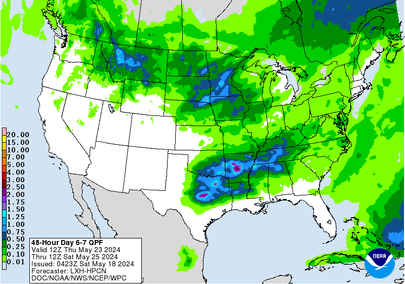
Still looking very wet and potentially stormy Friday into early Sunday.
- Attachments
-
Carla/Alicia/Jerry(In The Eye)/Michelle/Charley/Ivan/Dennis/Katrina/Rita/Wilma/Humberto/Ike/Harvey
Member: National Weather Association
Facebook.com/Weather Infinity
Twitter @WeatherInfinity
Member: National Weather Association
Facebook.com/Weather Infinity
Twitter @WeatherInfinity
-
tireman4

- Global Moderator
- Posts: 4488
- Joined: Wed Feb 03, 2010 9:24 pm
- Location: Humble, Texas
- Contact:
Well, most locations took in a lot of rain. We survived it. Many thanks to the mets on here (Wxman57, Srain, Jeff, Brooks, Andrew, David) as well as countless others that helped during this time. It could have been a lot worse. Keep a weather eye to the sky later on this week and hopefully the kiddos are not drenched during Trick or Treat Time ( Yep, I will be out there with my little one..LOL)