
November 2015: Ending Cold & Rainy
-
Houstonkid
- Posts: 53
- Joined: Mon Feb 08, 2010 2:31 pm
- Contact:
So what happened? Why was this such a bust? What elements where missing?
-
tireman4

- Global Moderator

- Posts: 4489
- Joined: Wed Feb 03, 2010 9:24 pm
- Location: Humble, Texas
- Contact:
This might help...explain...
FXUS64 KHGX 171735
AFDHGX
AREA FORECAST DISCUSSION
NATIONAL WEATHER SERVICE HOUSTON/GALVESTON TX
1135 AM CST TUE NOV 17 2015
.DISCUSSION...
18Z AVIATION...CF IS THRU IAH AND SGR AND IS APPROACHING HOU AND
WILL BE THERE PRIOR TO 18Z. MOST CONVECTION IS BEHIND THE FRONT.
WE ARE SEEING GUSTS AROUND 35 KTS WITH THE FRONT WHICH SUBSIDE
AFTER THE BOUNDARY MOVES THROUGH. WILL SEE THE CHC OF ELEVATED
TSRA A COUPLE OF HOURS BEHIND THE BOUNDARY. SHOULD SEE LOW CLOUDS
MOVE FROM WEST TO EAST ACROSS SE TX LATE THIS AFT/EARLY THIS EVE
WITH SOME MID/HIGH CLOUD COVER REMAINING THIS EVENING. 33
&&
.PRELIMINARY POINT TEMPS/POPS...
COLLEGE STATION (CLL) 73 48 70 49 72 / 100 0 0 0 0
HOUSTON (IAH) 76 50 73 49 75 / 100 20 0 0 0
GALVESTON (GLS) 74 57 71 60 73 / 90 40 0 0 0
&&
.HGX WATCHES/WARNINGS/ADVISORIES...
TX...WIND ADVISORY UNTIL 1 PM CST THIS AFTERNOON FOR THE FOLLOWING
ZONES: BRAZORIA...CHAMBERS...FORT BEND...GALVESTON...
HARRIS...JACKSON...LIBERTY...MATAGORDA...WHARTON.
GM...SMALL CRAFT ADVISORY UNTIL 6 PM CST THIS EVENING FOR THE
FOLLOWING ZONES: GALVESTON BAY...MATAGORDA BAY...WATERS
FROM FREEPORT TO THE MATAGORDA SHIP CHANNEL 20 NM TO 60
NM...WATERS FROM FREEPORT TO THE MATAGORDA SHIP CHANNEL OUT
20 NM...WATERS FROM HIGH ISLAND TO FREEPORT 20 TO 60 NM...
WATERS FROM HIGH ISLAND TO FREEPORT OUT 20 NM.
&&
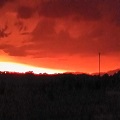
I am hearing the first rumblings of thunder here in Stafford, but the rain appears to be clearing out.
looks to be clearing out to the west - heaviest rain to the east. Love the temperature drop!!!!! feeling a little like Autumn
-
Stormrider
- Posts: 109
- Joined: Wed Feb 03, 2010 11:50 pm
- Contact:
Was outside in Galveston when the fromt blew through. Wind shifted and the temp dropped almost immediately. A few rounds of heavy rain and thunder, but it has stopped for the moment. It's 56 now. down from about 75 a couple hours ago.
Rain has totally stopped here in Stafford. Temps are wonderful! I have all the windows open and a long sleeve shirt on. Quite a difference from the 81 degrees we reached this morning. Still some thick clouds in the sky, interesting to watch those clouds sliding away. I don't know alot about weather, but love watching the fronts blow in and blow out.

We are fine here in Spring-Woodlands. For all the drama, it didn't do a whole lot at all in our area. Just some heavy rain and gusty winds, but that was about it. I barely heard any thunder.
The temps felt great stepping outside after a run on the treadmill!!
The temps felt great stepping outside after a run on the treadmill!!

Biggest issue appears to have been capping from the SW which several of the high resolution models were indicating. Capping was strong enough to keep warm sector development down and tied strongly to the cold front which was quickly undercutting the thunderstorm activity. Overall I expected more severe wind damage with the line than what actually transpired given some much wind energy aloft...but without significant updrafts it was hard to bring this to the surface.Houstonkid wrote:After a week of hyping tornadoes, severe wind and possibly hail this thing blows in like a lamb for most of us. Not even a clap of thunder here on the NW side of Houston.

Plenty of action in Brazos and Grimes Cos. About 2.33 in of rain, gust winds, two tornado warnings in the very early am. Some wind damage. A pretty full morning.tireman4 wrote:Well, this is more a question for Srain, Wxman 57, Andrew and the like, but my guess is that the dynamics (shear and such) moved more Eastward and Northward...
-
Katdaddy

- Global Moderator
- Posts: 2502
- Joined: Thu Feb 04, 2010 8:18 am
- Location: League City, Tx
- Contact:
Its a chilly morning with temps in the upper 40s and 50s. Beautiful TX weather through the rest of the week. Clouds and slight rains chances arrive for the weekend ahead of the next front Saturday night which may bring down the coldest Fall temps yet.
looks like a warm up with rain on Thanksgiving. Terrible timing. 
-
srainhoutx

- Site Admin

- Posts: 19616
- Joined: Tue Feb 02, 2010 2:32 pm
- Location: Maggie Valley, NC
- Contact:
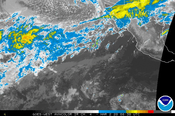
Eyes may need to turn to the Eastern Pacific where 90E is showing signs of developing into a tropical cyclone eventually re curving back toward the Baja Peninsula with its mid/upper level moisture spreading across Mexico and possibly Texas early next week.
- Attachments
-
Carla/Alicia/Jerry(In The Eye)/Michelle/Charley/Ivan/Dennis/Katrina/Rita/Wilma/Humberto/Ike/Harvey
Member: National Weather Association
Facebook.com/Weather Infinity
Twitter @WeatherInfinity
Member: National Weather Association
Facebook.com/Weather Infinity
Twitter @WeatherInfinity
srainhoutx what is Thanksgiving looking like.
-
srainhoutx
- Site Admin
- Posts: 19616
- Joined: Tue Feb 02, 2010 2:32 pm
- Location: Maggie Valley, NC
- Contact:
The EPO continues to tank towards negative territory while the PNA is showing signs of going positive. Look for a lot of run to run volatility via the various computer models as they try to figure out the evolving sensible weather pattern for the next week or two.cperk wrote:srainhoutx what is Thanksgiving looking like.
- Attachments
-
Carla/Alicia/Jerry(In The Eye)/Michelle/Charley/Ivan/Dennis/Katrina/Rita/Wilma/Humberto/Ike/Harvey
Member: National Weather Association
Facebook.com/Weather Infinity
Twitter @WeatherInfinity
Member: National Weather Association
Facebook.com/Weather Infinity
Twitter @WeatherInfinity
-
srainhoutx
- Site Admin
- Posts: 19616
- Joined: Tue Feb 02, 2010 2:32 pm
- Location: Maggie Valley, NC
- Contact:
Morning briefing from Jeff:
Active storm track to continue across the southern plains into December with increasingly colder air masses.
Dry and cool air mass in place this morning a big contrast to yesterday morning with current dewpoints running some 20-30 degrees lower. Upper level storm system responsible for the active weather on Tuesday is moving NW out of the central plains with modified Canadian air mass advecting southward over the recent snowfall over the western high plains and eastern Rockies. This will result in clear and cool weather for SE TX today-Friday with lows in the 40’s/50’s and highs in the 60’s/70’s.
Stronger cold front will plunge down the plains on Friday and arrive into SE TX Saturday. Moisture begins to increase Friday afternoon and expect an increase in cloud cover and likely a few showers with the frontal passage early Saturday. Air mass behind this front is cold and high temperatures will be prior to the front on Saturday with falling temperatures in the afternoon into the 50’s. Cold air advection continues into Sunday with lows falling well into the 40’s…maybe even a few 30’s over the area and highs only near 60. Temperature forecast for the weekend and early next week will depend on how much high cloud cover moves over the region from a developing tropical cyclone off the MX west coast.
Forecast models are not is very good agreement on next week as the next storm system moves into the SW US and a tropical system lingers off the MX west coast. General consensus is for a dry…cold…but possibly cloudy start to the week with air mass modification taking place by Wednesday as winds return to the south. Thanksgiving-Sunday looks potential warmer, but wet with increasingly SW slow aloft delivering disturbances across increasing moisture ahead of the next big storm system that looks to move across TX the weekend after Thanksgiving.
Carla/Alicia/Jerry(In The Eye)/Michelle/Charley/Ivan/Dennis/Katrina/Rita/Wilma/Humberto/Ike/Harvey
Member: National Weather Association
Facebook.com/Weather Infinity
Twitter @WeatherInfinity
Member: National Weather Association
Facebook.com/Weather Infinity
Twitter @WeatherInfinity
-
srainhoutx
- Site Admin
- Posts: 19616
- Joined: Tue Feb 02, 2010 2:32 pm
- Location: Maggie Valley, NC
- Contact:
The 12Z NAM and GFS suggest the next front will have a bit of a bite with it regarding colder air as well as showers both pre and post frontal Saturday afternoon. Temperatures look to drop into the 40's across our Region during the early afternoon/evening Saturday. There is also a good swath of snow expected across Colorado into the Plains. Tis the season...stepping down... 
- Attachments
-
Carla/Alicia/Jerry(In The Eye)/Michelle/Charley/Ivan/Dennis/Katrina/Rita/Wilma/Humberto/Ike/Harvey
Member: National Weather Association
Facebook.com/Weather Infinity
Twitter @WeatherInfinity
Member: National Weather Association
Facebook.com/Weather Infinity
Twitter @WeatherInfinity
-
srainhoutx
- Site Admin
- Posts: 19616
- Joined: Tue Feb 02, 2010 2:32 pm
- Location: Maggie Valley, NC
- Contact:
The very long range 12Z GFS suggests a potential hard freeze as folks travel home from their Thanksgiving Holiday.
- Attachments
-
-
Carla/Alicia/Jerry(In The Eye)/Michelle/Charley/Ivan/Dennis/Katrina/Rita/Wilma/Humberto/Ike/Harvey
Member: National Weather Association
Facebook.com/Weather Infinity
Twitter @WeatherInfinity
Member: National Weather Association
Facebook.com/Weather Infinity
Twitter @WeatherInfinity
-
GBinGrimes
- Posts: 108
- Joined: Mon Jan 27, 2014 1:50 pm
- Location: Anderson, TX
- Contact:
"The very long range 12Z GFS suggests a potential hard freeze as folks travel home from their Thanksgiving Holiday."
Well.....DANG!! Texas weather sure is crazy.
Well.....DANG!! Texas weather sure is crazy.