
Yes it has. Do not get caught up in what people call 'climate change' when in fact it is called a "weather pattern" which could last for years. When rain chances decrease for an extended period of time and we have an unusual warm winter, people start to over think. There is nothing unusual about what is going on...we just aren't used to this since we haven't seen a weather pattern like this in our lifetime but guaranteed, many before us have.BiggieSmalls wrote:Correct me if I'm wrong, but hasn't Texas, as a state split by the "dry" line through America (see below) always been in the middle of a tug-of-war between the dry climates to the west and the rainy climates to the east? In other words...sometimes the eastern (populated) half of Texas is an extension of Louisiana and points east in terms of rainfall..and sometimes its more an extension of west Texas/New Mexico and points west. I think some Texans get trapped into thinking that it is "normal" to get 40+ inches of rain each and every year, and act shocked when it doesn't happen. IMO our climate in terms of rainfall just is what it is - periods of too dry or too wet extremes.
March 2016 - Progressive Changeable Weather To End The Month
-
redneckweather
- Posts: 1023
- Joined: Mon Feb 08, 2010 7:29 pm
- Location: Montgomery, Texas
- Contact:

When the drought of 2011 was the worst in at least 1,000 years, according to tree-ring studies, I'd call that unusual. Nobody has ever seen anything like it. We've also seen a lot more flash flooding events, and we're talking repeated 100, 500 & 1,000 year events become more frequent, just in the last couple of decades. That's unprecedented and unusual too.
When the ends of your bell curve, data points that are normally tossed out -- when they start to become the norm, at some point you have to know something isn't right.
When you have a hypothesis, and you start to see the projected evidence of that hypothesis play out, repeatedly, you have to think the hypothesis has some validity.
-
Katdaddy

- Global Moderator

- Posts: 2502
- Joined: Thu Feb 04, 2010 8:18 am
- Location: League City, Tx
- Contact:
Highs in the low 80s will drop into the mid 70s through the weekend behind a dry cool front this afternoon as nice Spring weather continues with mostly sunny to partly sunny skies. Still several days out but the threat for heavy rain and severe weather across a large portion of TX early next week remain. The SPC has 15% risk areas across portion of the S Plains for Monday and Tuesday. All of SE TX is included in the risk area Tuesday.
From this morning's Hou-Gal HWO:
.DAYS TWO THROUGH SEVEN...FRIDAY THROUGH WEDNESDAY
A STRONG UPPER LEVEL STORM SYSTEM WILL APPROACH TEXAS BY THE END
OF THE WEEKEND...PRODUCING A CHANCE OF THUNDERSTORMS FROM MONDAY
THROUGH WEDNESDAY. WHILE THERE ARE MAJOR UNCERTAINTIES REGARDING
THE DETAILS OF THIS SYSTEM...SOME POTENTIAL FOR STRONG OR SEVERE
STORMS AND HEAVY RAINFALL COULD EXIST ACROSS SOUTHEAST TEXAS
DURING THIS TIME.
- Attachments
-
-
- Screen Shot 2016-03-03 at 5.24.20 AM.png (12.1 KiB) Viewed 4362 times
-
- Screen Shot 2016-03-03 at 5.24.11 AM.png (13.58 KiB) Viewed 4362 times
-
srainhoutx

- Site Admin

- Posts: 19616
- Joined: Tue Feb 02, 2010 2:32 pm
- Location: Maggie Valley, NC
- Contact:
The overnight guidance indicate that the very deep Western trough may not be as progressive as early anticipated suggesting a chance of heavier rainfall potential as well as strong to possibly severe thunderstorm development beginning Monday afternoon/evening across portions of Central Texas near the dryline and possibly organizing into a MCS on Tuesday across portions of East, SE Texas extending into Louisiana. It is noteworthy that the upper trough may be a bit slower to eject East and there are some indications that a potent closed 500mb low will meander near the Austin area into Wednesday night, possibly Thursday before slowly lifting early Friday. The Storm Prediction Center has outlined the potential for severe thunderstorms across Central Texas for Monday and across SE, East Texas into Louisiana for Tuesday. We will need to monitor the trends the next several days for the potential of additional unsettled weather just beyond the mid next week timeframe for the possibility of some heavy rainfall as we get a bit closer to the weather events of early to mid next week.
- Attachments
-
-
Carla/Alicia/Jerry(In The Eye)/Michelle/Charley/Ivan/Dennis/Katrina/Rita/Wilma/Humberto/Ike/Harvey
Member: National Weather Association
Facebook.com/Weather Infinity
Twitter @WeatherInfinity
Member: National Weather Association
Facebook.com/Weather Infinity
Twitter @WeatherInfinity
guess I'll wait to put down a new layer of mulch, so it's easier for the rain to soak through it - can't wait for it to wash away the pollen !
also an fyi - OSU's PRISM Clmate Group has a great website, data tools, etc... http://www.prism.oregonstate.edu/ including their "Explorer" function which lets you see data by state/county over a period of your choice - extremely easy to use and understand.
I found them through a link from http://climatexas.tamu.edu/index.php/ne ... -1981-2010
PS - TX state climo's high-res experimental drought data: http://atmo.tamu.edu/osc/drought/ )
-
srainhoutx
- Site Admin
- Posts: 19616
- Joined: Tue Feb 02, 2010 2:32 pm
- Location: Maggie Valley, NC
- Contact:
Briefing from Jeff regarding next week:
Prolonged period of stormy weather heading or TX next week.
Major upper air pattern change will revert the recent strong of weeks of mostly dry weather into a much more stormy pattern by early next week. Potential for high impact episodes of severe weather and heavy rainfall will be possible from Tuesday to possibly Thursday and Friday of next week.
An upper level storm system currently south of the Gulf of Alaska will drop toward California and then SE into the SW US and N MX by early next week. The upper flow over TX will become SW on the east side of the large upper level trough dragging Pacific high level moisture and upper air disturbances into the region along with good low level moisture advection from the Gulf of Mexico. The upper level storm system slows and possibly even cuts-off (stalls) over NE MX or far W TX Tuesday into Wednesday pumping copious moisture into the region with favorable upper level winds spreading apart aloft to produce good lift of the moist air mass. End result appears to be several rounds of thunderstorms with both severe weather and heavy rainfall possible.
Timing of the individual upper air impulses around the main upper level trough is impossible to determine, but will likely be tied to the most active periods of next week. Models are keying in on Tuesday and Wednesday and again late Thursday into Saturday for potential for thunderstorm complex formation over SW TX which would move ENE into SE TX. Latest 12Z guidance did come in significantly wetter for the entire period, but models have not been showing good QPF forecasts these last few days on overall rainfall amounts and if a more significant flood threat is in the making.
Given we are still 3-4 days before any onset or impacts from the this system, the fine details will be worked out over the weekend into early next week along with the possible severe weather modes and rainfall totals.
Carla/Alicia/Jerry(In The Eye)/Michelle/Charley/Ivan/Dennis/Katrina/Rita/Wilma/Humberto/Ike/Harvey
Member: National Weather Association
Facebook.com/Weather Infinity
Twitter @WeatherInfinity
Member: National Weather Association
Facebook.com/Weather Infinity
Twitter @WeatherInfinity
-
Andrew
- Site Admin
- Posts: 3440
- Joined: Wed Feb 03, 2010 9:46 pm
- Location: North-West Houston
- Contact:
00z GFS is starting to come together for a possible severe outbreak across much of SE Texas. As the upper level low approaches the region multiple shortwaves will cross the state and bring with it multiple series of severe weather and heavy rain. It also looks like cyclogenesis could occur multiple times across the state but for local weather (SE Texas) Tuesday night into Wednesday could be the most active as a coastal low develops and produces favorable low level winds. Around this time a strong ~50kt LLJ could develop and further amplify the situation. Timing still looks like an issue especially since this ULL could stall across the state (and that is always difficult to forecast) but even if this occurs in the overnight hours, lapse rates would still support enough energy for thunderstorms and possibly severe weather. Finally, it looks like rain could stick around for much of the week as it takes until the end of week for this system to finally eject. Overall an active period as Jeff and Srain has stated above.
For Your Infinite Source For All Things Weather Visit Our Facebook
SPC DAY 4-8 CONVECTIVE OUTLOOK
NWS STORM PREDICTION CENTER NORMAN OK
0349 AM CST FRI MAR 04 2016
VALID 071200Z - 121200Z
...d4/mon and d5/tue...
a shortwave trough near the four corners area at 12z/mon should shift towards neb by 12z/tue... while a more amplified trough digs along the srn ca coast across baja ca towards sonora. a lee cyclone should gradually eject from ern co to the mid-mo valley... with an attendant dryline mixing into cntrl ks to the edwards plateau of tx. while moisture quantity is unlikely to be overly great... rather steep mid-level lapse rates and strengthening mid-level swlys should support a risk for at least isolated supercells along much of the dryline by mon evening. more widespread tstm development is expected mon night across cntrl/nrn tx as mid-level height falls and low-level waa increase.
despite a probable large swath of convection ongoing at 12z/tue... both the ecmwf/gfs indicate greater mucape within the warm sector on d5 versus d4 given richer maritime tropical air spreading inland from the wrn gulf. it is plausible that in the wake of early-day convection... robust diabatic heating could occur across s tx. this may support another round of severe storms tue evening/night. although flow will become increasingly meridional through the period... a strong sly llj should be maintained across parts of ern tx to the lower ms valley. this may support a long-duration tornado risk... with hail/wind threats being more predominant upstream.
days 4-5 & 6-7 QPF http://www.wpc.ncep.noaa.gov/qpf/day1-7.shtml
-
srainhoutx
- Site Admin
- Posts: 19616
- Joined: Tue Feb 02, 2010 2:32 pm
- Location: Maggie Valley, NC
- Contact:
Looks like we will have some interesting weather to follow next week. Typically a cutoff slow meandering upper low in March with a deep digging upper trough that extends well into Mexico spells trouble with a heavy rainfall potential and the possibility of repeated strong to severe storms. The cold front never really clears our area and with a Coastal low potential, I would not be surprise to see rainfall totals increase across SE/East Texas into Arkansas and Louisiana.
EXTENDED FORECAST DISCUSSION
NWS WEATHER PREDICTION CENTER COLLEGE PARK MD
1112 AM EST FRI MAR 04 2016
VALID 12Z MON MAR 07 2016 - 12Z FRI MAR 11 2016
...HIGH CONFIDENCE MULTI-DAY HEAVY RAINFALL EVENT TO IMPACT EAST
CENTRAL U.S....
...WET PATTERN CONTINUES FOR NORTHWESTERN U.S. INTO CALIFORNIA...
...GENERAL OVERVIEW/MODEL ASSESSMENT...
THE GUIDANCE FOR THE MEDIUM RANGE PERIOD CONTINUES TO SHOW A VERY
ACTIVE PATTERN ACROSS BOTH THE WEST COAST AND THE CENTRAL STATES.
OUT WEST...MULTIPLE SYSTEMS EJECT OUT OF A MEAN TROUGH IN THE
EAST-CENTRAL PACIFIC WHILE A MULTI-DAY HEAVY RAINFALL EVENT SETS
UP FROM THE CENTRAL GULF COAST TO THE OHIO VALLEY. THIS IS DUE IN
PART TO A FUNNELING OF GULF OF MEXICO MOISTURE IN BETWEEN A STRONG
RIDGE BUILDING ACROSS THE EASTERN STATES AND A DEEP CLOSED UPPER
LOW MOVING INTO THE RIO GRANDE VALLEY AND NORTHERN MEXICO.
MODELS SHOW REMARKABLE CLUSTER AND ABOVE AVERAGE PREDICTABILITY
THROUGHOUT THE MAJORITY OF THE 5 DAY PERIOD WITH REGARDS TO BOTH
THE STRONG RIDGING OVER THE EASTERN U.S. AND THE DEEP
TROUGH/CLOSED LOW ACROSS THE SOUTH CENTRAL STATES. THE BIGGEST
DIFFERENCE IS THE DETERMINISTIC CANADIAN WANTS TO MAINTAIN AN
ELONGATED UPPER TROUGH BUT THE ENSEMBLE MEAN SUPPORTS A CLOSED OFF
UPPER LOW SIMILAR TO THAT OF THE DETERMINISTIC GFS/ECMWF AND THEIR
RESPECTIVE ENSEMBLE MEANS. OUT WEST...THE ECMWF IS A BIT FARTHER
SOUTH BY DAY 6 WITH THE MAIN SURFACE LOW THAN THE GFS...BUT THE
ENSEMBLE MEAN NOW MORE CLOSELY MATCHES THAT OF THE GFS/GEFS
SOLUTION. ACROSS THE BOARD...THE WPC PROGS SUPPORTS A
GFS/ECMWF/GEFS/ECENS BLEND WHICH IS VERY SIMILAR TO CONTINUITY
FROM OVERNIGHT.
...SENSIBLE WEATHER HIGHLIGHTS...
WEST -- THE SYSTEM INITIALLY PUSHING ONSHORE IN CALIFORNIA SHOULD
BRING SOME FOCUSED PRECIPITATION TO THE SOUTHERN HALF OF THE STATE
EARLY IN THE PERIOD WHILE LIGHTER AND MORE SCATTERED PRECIPITATION
AFFECTS THE INTERMOUNTAIN WEST AND PACIFIC NORTHWEST...WITH THE
MOST ORGANIZED ACTIVITY FOCUSED ALONG THE HIGHER TERRAIN. THE NEXT
SURGE OF MOISTURE SHOULD IMPACT THE NORTHWEST COAST IN THE TUESDAY
TO THURSDAY TIME FRAME. DETAILS ON HOW FAR SOUTH THE HEAVY PRECIP
WILL REACH IS STILL UNCERTAIN GIVEN MODEL DIFFERENCES...BUT
CURRENTLY THE FORECAST SHOWS THE HEAVIEST PRECIP FOCUSING THE
COASTAL RANGES OF WASHINGTON AND OREGON TUES INTO WEDNESDAY
EVENTUALLY PUSHING INTO THE NORTHWEST CALIFORNIA MOUNTAINS BY
THURSDAY.
SOUTHERN PLAINS/MISSISSIPPI VALLEY -- GUIDANCE SUPPORTS A
MULTI-DAY HEAVY RAINFALL EVENT FROM THE CENTRAL GULF COAST TO THE
OHIO VALLEY AS AMPLE MOISTURE GETS PULLED UP AHEAD OF A SLOW
MOVING COLD FRONT. THE GREATEST TOTALS SHOULD FOCUS FROM NORTHEAST
TEXAS INTO THE MID-MISSISSIPPI VALLEY/LOWER OHIO VALLEY. 5 DAY
RAINFALL ACCUMULATIONS COULD POSSIBLY APPROACH OR EXCEED 10 INCHES
IN LOCALIZED AREAS ESPECIALLY ACROSS THE LOWER MISSISSIPPI VALLEY.
STRONG TO SEVERE CONVECTION IS ALSO POSSIBLE IN THE SAME AREAS SO
REFER TO THE SPC OUTLOOKS FOR MORE INFORMATION.
EASTERN U.S. -- WHILE THE WEST COAST STATES SHOULD SEE NEAR OR
BELOW NORMAL DAYTIME TEMPERATURES...EAST OF THE CONTINENTAL DIVIDE
CAN EXPECT VERY WARM CONDITIONS. DAYTIME TEMPERATURES COULD SOAR
20 TO 30 DEGREES ABOVE NORMAL FOR MANY IN THE CENTRAL U.S. DAY
3...PROGRESSING INTO THE EASTERN STATES BY DAY 5. OVERNIGHT CLOUD
COVER AND STRONG SOUTHERLY FLOW SHOULD PROMOTE ABOVE AVERAGE
MINIMUM TEMPERATURES AS WELL WHICH COULD CHALLENGE OR BREAK
RECORDS.
SANTORELLI
Carla/Alicia/Jerry(In The Eye)/Michelle/Charley/Ivan/Dennis/Katrina/Rita/Wilma/Humberto/Ike/Harvey
Member: National Weather Association
Facebook.com/Weather Infinity
Twitter @WeatherInfinity
Member: National Weather Association
Facebook.com/Weather Infinity
Twitter @WeatherInfinity

The battle between east and west is a nice way to put it. Keep in mind that if not for the Gulf of Mexico, the southern US would be mostly desert-like west of the Appalachians and south of Illinois. Rich Gulf moisture during the Spring and summer feeds many of the storms (sometimes violently) that provide rainfall. It's interaction with the southern jet in the Spring, ULL, is complex...but lows moving eastward and NE pick up substantial Gulf moisture which provide an ample source of water vapor as a warm, shallow bu expansive body of water.BiggieSmalls wrote:

Conversely if the GoM extended westward we would have more rain.
CC is more likely to affect our wet and dry patterns than actual temperature. Texas is already prone to droughts and floods. It's possible that tornado season might be a little earlier with more of a shift southeastward. How does CC affect the upper level ridge (i.e., death ridge) that forms in the summer? It's location? Because Texas is prone to such high variation, understanding the interaction of CC will be challenging indeed.
-
srainhoutx
- Site Admin
- Posts: 19616
- Joined: Tue Feb 02, 2010 2:32 pm
- Location: Maggie Valley, NC
- Contact:
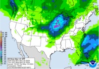
As expected, the QPF continues to increase with every update from the Weather Predication Center. The ensembles suggest an extended period of unsettled weather with almost daily shower and storm chance beginning late Sunday continuing until late next Thursday/early Friday. Also notice how wet California will be, if the quantitative precipitation forecast is correct. The QPF suggest up to 2 inches of rain in the Los Angeles Basin with near 20 inches across Coastal portions of Northern California. 10+ inches across the Ozarks also would create flooding issues extending back SW into East Texas where heavier training storm may be possible Tuesday through the overnight hours into early Wednesday.
- Attachments
-
Carla/Alicia/Jerry(In The Eye)/Michelle/Charley/Ivan/Dennis/Katrina/Rita/Wilma/Humberto/Ike/Harvey
Member: National Weather Association
Facebook.com/Weather Infinity
Twitter @WeatherInfinity
Member: National Weather Association
Facebook.com/Weather Infinity
Twitter @WeatherInfinity
-
Katdaddy
- Global Moderator
- Posts: 2502
- Joined: Thu Feb 04, 2010 8:18 am
- Location: League City, Tx
- Contact:
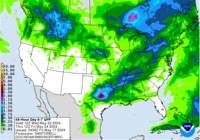
Enjoy this beautiful SE TX Spring weather this weekend because a big change is on the way to an active weather pattern next week with a large upper level low dropping into N MX before moving slowly across the S Plains. Heavy rains and severe weather will be possible Tuesday and Wednesday across SE TX.
- Attachments
-
- Screen Shot 2016-03-05 at 7.13.29 AM.png (11.12 KiB) Viewed 4829 times
-
- Screen Shot 2016-03-05 at 7.13.35 AM.png (9.93 KiB) Viewed 4829 times
WPC's afternoon update http://www.wpc.ncep.noaa.gov/qpf/qpf2.shtml
6-hourly loop days 1-7 http://www.wpc.ncep.noaa.gov/qpf/qpfloop_6hr_d17.html
happy trees !
6-hourly loop days 1-7 http://www.wpc.ncep.noaa.gov/qpf/qpfloop_6hr_d17.html
happy trees !
-
srainhoutx
- Site Admin
- Posts: 19616
- Joined: Tue Feb 02, 2010 2:32 pm
- Location: Maggie Valley, NC
- Contact:
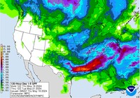
A very active weather week appears to be developing with not only a severe weather threat beginning tomorrow afternoon into the overnight hours in West Central Texas extending through Wednesday across East Texas and Louisiana, but a heavy rainfall event is also possible with repeating rounds of heavy rainfall and possibly training strong to possibly severe thunderstorm activity as a very deep cut off upper low near 5 standard deviation below normal organizes over Mexico and meanders until late week to our SW. Tuesday night into Wednesday needs to be closely monitored for all forms of severe weather as well as Flash Flooding. Stay weather wise during the upcoming work week.
DAY 3 CONVECTIVE OUTLOOK
NWS STORM PREDICTION CENTER NORMAN OK
0229 AM CST SUN MAR 06 2016
VALID 081200Z - 091200Z
...THERE IS A SLGT RISK OF SVR TSTMS S-CNTRL STATES...
...THERE IS A MRGL RISK OF SVR TSTMS AROUND THE SLGT RISK IN THE
S-CNTRL STATES...
...SUMMARY...
EPISODIC ISOLATED TO SCATTERED SEVERE STORMS ARE ANTICIPATED FROM
PARTS OF THE RED RIVER TO LOWER RIO GRANDE VALLEYS ON TUESDAY INTO
EARLY WEDNESDAY.
...SYNOPSIS...
CONSENSUS OF GUIDANCE SUGGESTS AN AMPLIFIED UPPER TROUGH SHOULD
CONTINUE TO SLIDE SE ACROSS NW MEXICO. THIS WILL YIELD AN
INCREASINGLY MERIDIONAL FLOW REGIME DOWNSTREAM ACROSS THE S-CNTRL
CONUS. BEYOND A DRYLINE LIKELY MIXING INTO THE BIG COUNTRY/EDWARDS
PLATEAU OF TX TUE AFTERNOON...THE SURFACE PATTERN APPEARS NEBULOUS
AND SHOULD CONSIST OF NUMEROUS CONVECTIVE OUTFLOWS WITHIN THE
MODIFYING WARM SECTOR AS MASSIVE OVERTURNING OCCURS BY 12Z/WED.
...S-CNTRL STATES...
A 50-60 KT LLJ SHOULD SHIFT EWD FROM CNTRL/ERN TX TO AR/LA ON TUE
MORNING INTO EVENING...PRIOR TO INTENSIFYING FARTHER S/SW ALONG THE
UPPER TX GULF COAST AND NWRN GULF EARLY WED. THIS SHOULD RESULT IN
MIDDLE 60S SURFACE DEW POINTS REACHING THE ARKLATEX REGION WITH
UPPER 60S ALONG MUCH OF THE TX GULF COASTAL PLAIN. ONE OR MORE TSTM
CLUSTERS WILL LIKELY BE ONGOING AT 12Z/TUE ACROSS PARTS OF CNTRL TO
N TX. THIS ACTIVITY SHOULD FORM AN EFFECTIVE NRN BOUNDARY TO ROBUST
DESTABILIZATION GIVEN THE MERIDIONAL FLOW REGIME. SUBSTANTIAL
DIABATIC HEATING WILL LIKELY BE LIMITED TO AREAS TO THE S/W IN
S-CNTRL/SE TX. RENEWED TSTM DEVELOPMENT ALONG TRAILING
OUTFLOWS/DRYLINE IS EXPECTED BY EVENING. UPSCALE GROWTH INTO AN
EXTENSIVE MCS APPEARS PROBABLE OVER SRN/ERN TX BY 12Z/WED.
GIVEN THE MERIDIONAL FLOW REGIME...CONVECTIVE MODE WILL LIKELY BE
COMPLEX/MIXED. OVERALL SETUP SUGGESTS THAT ANY ENHANCEMENTS TO
SEVERE COVERAGE WILL LIKELY BE DRIVEN ON THE MESOSCALE AND AS SUCH
WILL DEFER TO LATER OUTLOOKS REGARDING POTENTIALLY GREATER
PROBABILITIES. NEVERTHELESS...ALL SEVERE HAZARDS APPEAR POSSIBLE
THROUGH THE PERIOD...WITH THE TORNADO RISK COMPARATIVELY GREATER
WITHIN/NEAR THE STRONG LLJ.
..GRAMS.. 03/06/2016
Carla/Alicia/Jerry(In The Eye)/Michelle/Charley/Ivan/Dennis/Katrina/Rita/Wilma/Humberto/Ike/Harvey
Member: National Weather Association
Facebook.com/Weather Infinity
Twitter @WeatherInfinity
Member: National Weather Association
Facebook.com/Weather Infinity
Twitter @WeatherInfinity
-
srainhoutx
- Site Admin
- Posts: 19616
- Joined: Tue Feb 02, 2010 2:32 pm
- Location: Maggie Valley, NC
- Contact:
Morning briefing from Jeff:
Slow moving significant storm system to impact TX much of this week.
Severe weather and flooding rainfall over multiple days will be possible.
Discussion:
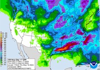
Powerful upper level storm system arriving into CA this morning will move SE into the SW US on Monday and then into MX on Tuesday where it slows and deepens. SE winds are already underway over TX helping to transport moisture into the region from the Gulf of Mexico, but this current moisture advection is shallow and trapped beneath a strong 800mb inversion (cap). This capping will maintain itself into Monday afternoon, before much more significant moisture arrives late Monday into early Tuesday. Moisture values climb from 1.0 in of PW to nearly 1.8 inches of PW by Tuesday afternoon which would be near record values for early March. Additionally, dry layer above 800mb rapidly moistens on Tuesday with the air column becoming nearly saturated by Tuesday afternoon. Upper level forcing will spread out of MX and across TX Tuesday-Thursday with several surface low formations and rounds of thunderstorms. Capping in the mid levels will be eroded by Tuesday afternoon from incoming cold air aloft along with several upper air disturbances and jet streaks. Upper winds become strong divergent early Wednesday morning and think this is when a very active period is going to transpire.
Monday night/Tuesday:
Short wave will eject out of the incoming large scale trough and develop thunderstorms over NE MX and SW TX. Some of these storms will become severe and this activity will move eastward, but likely weaken early Tuesday morning over C TX. Will need to watch for any boundary trying to move into SE TX early Tuesday that would help to focus development Tuesday afternoon.
Tuesday afternoon-Wednesday midday:
Significant short wave disturbance will likely result in widespread thunderstorms, heavy rainfall, and flash flooding.
Departing short wave Tuesday morning will give way to strong SE onshore flow by midday with significant moisture advection on a 50-60kt low level jet across coastal TX. Air mass will become increasingly unstable with current forecast sounding showing CAPE of over 2000 J/kg and LI’s down in the -4 area. Breaks in the overcast will only lead to more destabilization. Strong lift will spread across SW TX by early Tuesday afternoon and expect vigorous thunderstorm formation in NE MX/SW TX which will then move eastward Tuesday night. Severe parameters are maintained all night with a dramatic increase in the low level shear profiles Tuesday night favoring a threat for tornadoes and wind damage. Not sure how much development will occur over the warm sector ahead of what will by this time become a very well defined MCS over the TX coast bend into C TX where severe and excessive rainfall will be ongoing. Certainly could be cells developing in the warm sector with a tornado threat Tuesday evening and all night over SE TX. Severe probabilities upgrade may be required in additional outlooks if the tornado threat looks higher. All severe modes will be possible at this time with wind and tornadoes the greatest.
Other significant concern is going to be excessive rainfall and flash flooding. Well defined MCS will move slowly eastward into highly moist air mass being fed by 50-60kt low level jet Tuesday night/Wednesday morning. Forecast models want to slow down this MCS over coastal TX/SE TX Wednesday morning where favored wind field become parallel to the mean upper level flow…the result will likely be a period of prolonged cell training and cell mergers. Saturated air column in this setup is concerning for high hourly rainfall rates of 1-3 inches per hour and rapid onset flash flood event. HPC has already outlooked much of the region for slight to moderate risk for flash flooding and excessive rainfall.
Widespread rainfall amounts of 3-5 inches appear likely with isolated totals of 6-8 inches especially east of I-45 where cell training appears the greatest threat. 24-hour storm total from 600am Tuesday to 600am Wednesday are very impressive over the region with a solid 2-4 inches likely. Models have been trending southward and southwest with the axis of maximum rainfall the last few days from around Little Rock now toward Toledo Bend…which is concerning as values around the Sabine River in that same 24 hour period could be 6-9 inches.
Rainfall of this magnitude will cause significant rises on area creeks, bayous, and rivers. I am really worried about the Trinity and San Jacinto Basins given basin wide amounts of 3-5 inches is looking likely. However rises on all basins is almost certain given the widespread nature of the event. Urban flash flooding will also be a concern with higher hourly rainfall rates.
Wednesday afternoon-Thursday:
Hopefully the area will get into a break by Wednesday afternoon and Wednesday evening before another strong short wave rotates around the parent upper level storm which by this time will be located over NE MX/SW TX. Strong height falls will force surface low pressure over S TX which will move NE along or offshore of the TX coast. Current track of this feature is just offshore of SE TX coast and then inland over far E TX/W LA on Thursday. The track of this feature will be very important on additional rainfall on Thursday as another significant round of excessive rainfall will focus on the north and eastern side of this feature Thursday. Think our eastern counties could get clipped by this with the majority of the excessive rainfall over the Sabine River valley where another 6 inches could fall on top of the 6-9 inches on Wednesday. If this surface low tracks more across SE TX, then Thursday will be a very bad day across the region with excessive rainfall and flash flooding almost certain.
Friday:
Not done yet! Main upper level low will eject across TX during the day Friday into possibly Saturday. Very cold air aloft will result in an unstable air mass over the region by late morning with showers and thunderstorms developing. Cold air favors a hail threat with these storms. Think moisture will somewhat limited by Friday, but by that time any additional rainfall will likely lead to problems. Should see the main storm system exit to the east by late Friday, but the latest ECMWF is slower once again and lingers the system over the area in Saturday which would keep rain chances going another day.
Tides:
Strong onshore flow will develop later today and continue for the next 48 hours. SE winds of 25-35mph will raise tide levels along the coast and likely result in tidal run-up and minor coastal flooding at high tide on Monday with better potential on Tuesday as wave run-up is maximized. Total water levels may be up around 2.5-3.5 ft by Tuesday afternoon which could cause issues on Bolivar, near Surfside, and on the western side of Galveston Bay at Shoreacres.
Day 3 (Tuesday) Severe Weather Outlook:
[/i]
Slow moving significant storm system to impact TX much of this week.
Severe weather and flooding rainfall over multiple days will be possible.
Discussion:
Powerful upper level storm system arriving into CA this morning will move SE into the SW US on Monday and then into MX on Tuesday where it slows and deepens. SE winds are already underway over TX helping to transport moisture into the region from the Gulf of Mexico, but this current moisture advection is shallow and trapped beneath a strong 800mb inversion (cap). This capping will maintain itself into Monday afternoon, before much more significant moisture arrives late Monday into early Tuesday. Moisture values climb from 1.0 in of PW to nearly 1.8 inches of PW by Tuesday afternoon which would be near record values for early March. Additionally, dry layer above 800mb rapidly moistens on Tuesday with the air column becoming nearly saturated by Tuesday afternoon. Upper level forcing will spread out of MX and across TX Tuesday-Thursday with several surface low formations and rounds of thunderstorms. Capping in the mid levels will be eroded by Tuesday afternoon from incoming cold air aloft along with several upper air disturbances and jet streaks. Upper winds become strong divergent early Wednesday morning and think this is when a very active period is going to transpire.
Monday night/Tuesday:
Short wave will eject out of the incoming large scale trough and develop thunderstorms over NE MX and SW TX. Some of these storms will become severe and this activity will move eastward, but likely weaken early Tuesday morning over C TX. Will need to watch for any boundary trying to move into SE TX early Tuesday that would help to focus development Tuesday afternoon.
Tuesday afternoon-Wednesday midday:
Significant short wave disturbance will likely result in widespread thunderstorms, heavy rainfall, and flash flooding.
Departing short wave Tuesday morning will give way to strong SE onshore flow by midday with significant moisture advection on a 50-60kt low level jet across coastal TX. Air mass will become increasingly unstable with current forecast sounding showing CAPE of over 2000 J/kg and LI’s down in the -4 area. Breaks in the overcast will only lead to more destabilization. Strong lift will spread across SW TX by early Tuesday afternoon and expect vigorous thunderstorm formation in NE MX/SW TX which will then move eastward Tuesday night. Severe parameters are maintained all night with a dramatic increase in the low level shear profiles Tuesday night favoring a threat for tornadoes and wind damage. Not sure how much development will occur over the warm sector ahead of what will by this time become a very well defined MCS over the TX coast bend into C TX where severe and excessive rainfall will be ongoing. Certainly could be cells developing in the warm sector with a tornado threat Tuesday evening and all night over SE TX. Severe probabilities upgrade may be required in additional outlooks if the tornado threat looks higher. All severe modes will be possible at this time with wind and tornadoes the greatest.
Other significant concern is going to be excessive rainfall and flash flooding. Well defined MCS will move slowly eastward into highly moist air mass being fed by 50-60kt low level jet Tuesday night/Wednesday morning. Forecast models want to slow down this MCS over coastal TX/SE TX Wednesday morning where favored wind field become parallel to the mean upper level flow…the result will likely be a period of prolonged cell training and cell mergers. Saturated air column in this setup is concerning for high hourly rainfall rates of 1-3 inches per hour and rapid onset flash flood event. HPC has already outlooked much of the region for slight to moderate risk for flash flooding and excessive rainfall.
Widespread rainfall amounts of 3-5 inches appear likely with isolated totals of 6-8 inches especially east of I-45 where cell training appears the greatest threat. 24-hour storm total from 600am Tuesday to 600am Wednesday are very impressive over the region with a solid 2-4 inches likely. Models have been trending southward and southwest with the axis of maximum rainfall the last few days from around Little Rock now toward Toledo Bend…which is concerning as values around the Sabine River in that same 24 hour period could be 6-9 inches.
Rainfall of this magnitude will cause significant rises on area creeks, bayous, and rivers. I am really worried about the Trinity and San Jacinto Basins given basin wide amounts of 3-5 inches is looking likely. However rises on all basins is almost certain given the widespread nature of the event. Urban flash flooding will also be a concern with higher hourly rainfall rates.
Wednesday afternoon-Thursday:
Hopefully the area will get into a break by Wednesday afternoon and Wednesday evening before another strong short wave rotates around the parent upper level storm which by this time will be located over NE MX/SW TX. Strong height falls will force surface low pressure over S TX which will move NE along or offshore of the TX coast. Current track of this feature is just offshore of SE TX coast and then inland over far E TX/W LA on Thursday. The track of this feature will be very important on additional rainfall on Thursday as another significant round of excessive rainfall will focus on the north and eastern side of this feature Thursday. Think our eastern counties could get clipped by this with the majority of the excessive rainfall over the Sabine River valley where another 6 inches could fall on top of the 6-9 inches on Wednesday. If this surface low tracks more across SE TX, then Thursday will be a very bad day across the region with excessive rainfall and flash flooding almost certain.
Friday:
Not done yet! Main upper level low will eject across TX during the day Friday into possibly Saturday. Very cold air aloft will result in an unstable air mass over the region by late morning with showers and thunderstorms developing. Cold air favors a hail threat with these storms. Think moisture will somewhat limited by Friday, but by that time any additional rainfall will likely lead to problems. Should see the main storm system exit to the east by late Friday, but the latest ECMWF is slower once again and lingers the system over the area in Saturday which would keep rain chances going another day.
Tides:
Strong onshore flow will develop later today and continue for the next 48 hours. SE winds of 25-35mph will raise tide levels along the coast and likely result in tidal run-up and minor coastal flooding at high tide on Monday with better potential on Tuesday as wave run-up is maximized. Total water levels may be up around 2.5-3.5 ft by Tuesday afternoon which could cause issues on Bolivar, near Surfside, and on the western side of Galveston Bay at Shoreacres.
Day 3 (Tuesday) Severe Weather Outlook:
Carla/Alicia/Jerry(In The Eye)/Michelle/Charley/Ivan/Dennis/Katrina/Rita/Wilma/Humberto/Ike/Harvey
Member: National Weather Association
Facebook.com/Weather Infinity
Twitter @WeatherInfinity
Member: National Weather Association
Facebook.com/Weather Infinity
Twitter @WeatherInfinity
-
srainhoutx
- Site Admin
- Posts: 19616
- Joined: Tue Feb 02, 2010 2:32 pm
- Location: Maggie Valley, NC
- Contact:
The afternoon updated Weather Prediction Center Day 3 Excessive Rainfall Outlook now includes a Moderate Risk for most of SE Texas.
Carla/Alicia/Jerry(In The Eye)/Michelle/Charley/Ivan/Dennis/Katrina/Rita/Wilma/Humberto/Ike/Harvey
Member: National Weather Association
Facebook.com/Weather Infinity
Twitter @WeatherInfinity
Member: National Weather Association
Facebook.com/Weather Infinity
Twitter @WeatherInfinity
Is it my imagination or have there been frequent mentions of record to near record high values in moisuture content over the last year or so?
-
Andrew
- Site Admin
- Posts: 3440
- Joined: Wed Feb 03, 2010 9:46 pm
- Location: North-West Houston
- Contact:
Everything still looks on track for a heavy rain/ severe weather event for Tuesday night/ Wednesday morning. There are some inconsistencies between models on the track and timing of the upper level low but whatever happens flooding will be a concern. Severe weather on the other hand will be more dependent on the timing and location of the low. Current thinking is frontal passage will occur during the overnight hours which could limit some severe potential slightly, but I do think that with such steep lapse rates and a very favorable sheer profile, nocturnal severe weather will still remain a threat. I do believe straight line wind will be the main threat but can't discount a supercell potential ahead of the main line. Tonight will bring us into the range of the NAM-4k and the Tx-Tech WRF, providing more details on what to expect.
For Your Infinite Source For All Things Weather Visit Our Facebook
from NWS Lake Charles
https://www.facebook.com/NWSLakeCharles
We will be hosting a live weather briefing in about an hour, at 7:00 PM, to discuss the severe weather/flash flood threat expected later this week. We will attempt to broadcast the briefing via facebook live (wifi strength pending). We will also be broadcasting on YouTube at https://www.youtube.com/watch?v=P-m-ZgTAYSo
Public questions will also be answered by NWS meteorologists.
-
- Information
-
Who is online
Users browsing this forum: Ahrefs [Bot], Bing [Bot], Semrush [Bot] and 51 guests