
I imagine that last tweet was just precautionary, it was from about 10AM
https://twitter.com/usacegalveston
#AddicksandBarker: Residents living near the west and northwest side of dams should stay alert for information from their EOC.
April 2016 Recap: Regional Flood/Severe Weather
000
FXUS64 KHGX 242050
AFDHGX
AREA FORECAST DISCUSSION
NATIONAL WEATHER SERVICE HOUSTON/GALVESTON TX
350 PM CDT SUN APR 24 2016
.DISCUSSION...
AREA OF PCPN THAT ORIGINATED DOWN THE LOWER TX COAST (OVERNIGHT)
IS CURRENTLY MOVING ACROSS SE TX THIS AFTN. THE DISTURBANCE THAT
IS HELPING TO PRODUCE ALL THE ACTIVITY IS EXPECTED TO OUT OF THE
AREA TONIGHT. WHILE THESE RAINS HAVE WEAKENED A BIT AS THEY MOVE
INTO THE AREA...THEY ARE PERSISTING AND WE ARE SEEING SOME QUICK
ONE INCH TOTALS OVER PARTS OF WRN HARRIS COUNTY. OTHERWISE RAIN-
FALL TOTALS ARE AVERAGING FROM ONE QUARTER TO ONE HALF INCH.
AS PER THE ONGOING MODEL TRENDS...THIS DISTURBANCE APPEARS TO BE
THE FIRST IN A SERIES THROUGH THESE NEXT SEVERAL DAYS. THE UPPER
PATTERN IS AN ACTIVE ONE WITH THE NEXT UPPER LOW/TROF MOVING IN-
TO THE SRN PLAINS TUES AND ANOTHER FRI. THE SYSTEM ON TUES LOOKS
TO BRING ANOTHER DISTURBANCE ACROSS SE TX TUES NIGHT/WEDS (ALONG
WITH THE DRY LINE STALLING JUST TO OUR WEST). HOWEVER THE BETTER
RAIN CHCS COULD BE DURING THE LATTER PART OF THE WEEK. THIS SYS-
TEM PROGGED TO BE STRONGER/WITH A MORE SLY TRACK. WILL KEEP POPS
AOA CHC CATEGORY FOR THIS TIMEFRAME FOR NOW. 41
&&
.MARINE...
THE PASSAGE OF A SHORTWAVE TROUGH HAS GENERATED SCATTERED AFTERNOON
SHOWERS OVER THE COASTAL WATERS. A DEEPENING LOW PRESSURE SYSTEM
OVER WEST TEXAS HAS TIGHTENED THE PRESSURE GRADIENT...STRENGTHENING
AFTERNOON SOUTHERLIES TO JUST OVER CAUTION LEVELS. SCEC FLAGS ARE
RAISED FOR ALL UPPER TEXAS BAYS AND COASTAL WATERS THROUGH 12Z
TOMORROW MORNING.
A SERIES OF CENTRAL U.S. STORM SYSTEMS WILL TEMPORARILY TIGHTEN THE
ONSHORE PRESSURE GRADIENT THROUGH THE COMING WEEK...LIKELY PRODUCING
CAUTION LEVEL WINDS TUESDAY NIGHT THROUGH WEDNESDAY MORNING AND
AGAIN ON FRIDAY AND SATURDAY. ONSHORE WINDS ARE FORECAST TO
EXCEED ADVISORY THRESHOLDS GOING INTO NEXT WEEKEND.
TIDE LEVELS WILL REMAIN BETWEEN A HALF A FOOT TO A FOOT ABOVE NORMAL
FOR THE NEXT COUPLE OF DAYS. 44
&&
.PRELIMINARY POINT TEMPS/POPS...
COLLEGE STATION (CLL) 67 84 69 85 69 / 20 20 10 10 30
HOUSTON (IAH) 67 83 70 84 72 / 20 20 10 10 20
GALVESTON (GLS) 71 79 73 80 73 / 20 20 10 10 20
&&
.HGX WATCHES/WARNINGS/ADVISORIES...
TX...NONE.
GM...SMALL CRAFT SHOULD EXERCISE CAUTION THROUGH MONDAY MORNING FOR
THE FOLLOWING ZONES: MATAGORDA BAY...WATERS FROM FREEPORT
TO THE MATAGORDA SHIP CHANNEL 20 NM TO 60 NM...WATERS FROM
FREEPORT TO THE MATAGORDA SHIP CHANNEL OUT 20 NM.
SMALL CRAFT SHOULD EXERCISE CAUTION FROM 10 PM CDT THIS EVENING
THROUGH MONDAY MORNING FOR THE FOLLOWING ZONES: GALVESTON
BAY...WATERS FROM HIGH ISLAND TO FREEPORT 20 TO 60 NM...
WATERS FROM HIGH ISLAND TO FREEPORT OUT 20 NM.
&&
$$
DISCUSSION...99
-
Katdaddy

- Global Moderator

- Posts: 2502
- Joined: Thu Feb 04, 2010 8:18 am
- Location: League City, Tx
- Contact:
* FLOOD ADVISORY FOR...
SOUTHWESTERN MONTGOMERY COUNTY IN SOUTHEASTERN TEXAS...
NORTHWESTERN HARRIS COUNTY IN SOUTHEASTERN TEXAS...
* UNTIL 530 PM CDT
* AT 435 PM CDT...DOPPLER RADAR INDICATED HEAVY RAIN DUE TO
THUNDERSTORMS. THIS WILL CAUSE MINOR FLOODING IN THE ADVISORY AREA.
UP TO ONE INCH OF RAIN HAS ALREADY FALLEN AND AN ADDITIONAL INCH
WILL BE POSSIBLE IN SOUTHWESTERN MONTGOMERY COUNTY AS
THUNDERSTORMS MOVE FARTHER NORTH.
* SOME LOCATIONS THAT WILL EXPERIENCE FLOODING INCLUDE...
SOUTHERN CONROE...TOMBALL...JERSEY VILLAGE...PINEHURST...SPRING...THE
WOODLANDS...GREATER GREENSPOINT...OAK RIDGE NORTH...SHENANDOAH...
MAGNOLIA...STAGECOACH...WOODLOCH...CYPRESS...PORTER HEIGHTS...
SPLASHTOWN...WILLOWBROOK...HOOKS AIRPORT...THE WOODLANDS PAVILLION...
CHATEAU WOODS AND NORTHWESTERN BUSH INTERCONTINENTAL AIRPORT.
PRECAUTIONARY/PREPAREDNESS ACTIONS...
A FLOOD ADVISORY MEANS RIVER OR STREAM FLOWS ARE ELEVATED...OR PONDING
OF WATER IN URBAN OR OTHER AREAS IS OCCURRING OR IS IMMINENT.
FLOOD ADVISORY
NATIONAL WEATHER SERVICE HOUSTON/GALVESTON TX
450 PM CDT SUN APR 24 2016
THE NATIONAL WEATHER SERVICE IN LEAGUE CITY HAS ISSUED A
* FLOOD ADVISORY FOR...
SOUTHWESTERN HARRIS COUNTY IN SOUTHEASTERN TEXAS...
NORTH CENTRAL BRAZORIA COUNTY IN SOUTHEASTERN TEXAS...
EAST CENTRAL FORT BEND COUNTY IN SOUTHEASTERN TEXAS...
* UNTIL 545 PM CDT
* AT 448 PM CDT...DOPPLER RADAR AND AUTOMATED RAIN GAUGES INDICATED
HEAVY RAIN DUE TO THUNDERSTORMS. THIS WILL CAUSE MINOR FLOODING IN
THE ADVISORY AREA. AROUND ONE INCH OF RAINFALL HAS ALREADY FALLEN
IN THIS AREA... WITH SIMS BAYOU AT HIRAM-CLARKE ROAD REPORTING
1.20 INCHES OF RAINFALL SO FAR IN THE PAST HOUR.
* SOME LOCATIONS THAT WILL EXPERIENCE FLOODING INCLUDE...
PEARLAND...BELLAIRE...WEST UNIVERSITY PLACE...MANVEL...ASTRODOME AREA...
UNIVERSITY PLACE...GREATER THIRD WARD...GREATER HOBBY AREA...
MACGREGOR...GREATER EASTWOOD...FRESNO...GREENWAY / UPPER KIRBY AREA...
SOUTHSIDE PLACE...ARCOLA...BROOKSIDE VILLAGE...IOWA COLONY...GOLFCREST
/ BELLFORT / REVEILLE...WILLOWBEND...MINNETEX AND SOUTH MAIN.
ANOTHER INCH OF RAINFALL IS POSSIBLE OVER THIS AREA. THIS ADDITIONAL
RAIN WILL MAKE MINOR FLOODING.
PRECAUTIONARY/PREPAREDNESS ACTIONS...
A FLOOD ADVISORY MEANS RIVER OR STREAM FLOWS ARE ELEVATED...OR PONDING
OF WATER IN URBAN OR OTHER AREAS IS OCCURRING OR IS IMMINENT.
-
txflagwaver

- Posts: 411
- Joined: Wed Feb 03, 2010 2:37 pm
- Location: Seabrook/Kemah
- Contact:
Well...this was a surprise...

BULLETIN - EAS ACTIVATION REQUESTED
TORNADO WARNING
NATIONAL WEATHER SERVICE HOUSTON/GALVESTON TX
629 PM CDT SUN APR 24 2016
THE NATIONAL WEATHER SERVICE IN LEAGUE CITY HAS ISSUED A
* TORNADO WARNING FOR...
NORTHWESTERN GALVESTON COUNTY IN SOUTHEASTERN TEXAS...
SOUTHEASTERN HARRIS COUNTY IN SOUTHEASTERN TEXAS...
* UNTIL 700 PM CDT
* AT 628 PM CDT...A SEVERE THUNDERSTORM CAPABLE OF PRODUCING A TORNADO
WAS LOCATED OVER SOUTHEASTERN LEAGUE CITY...MOVING NORTHEAST AT 10
MPH.
HAZARD...TORNADO.
SOURCE...WEATHER SPOTTERS REPORTED A FUNNEL CLOUD ALONG HIGHWAY
646 EAST OF INTERSTATE 45.
IMPACT...EXPECT DAMAGE TO MOBILE HOMES...ROOFS...AND VEHICLES.
* LOCATIONS IMPACTED INCLUDE...
SOUTHEASTERN PASADENA...LEAGUE CITY...EASTERN FRIENDSWOOD...LA PORTE...
DICKINSON...SEABROOK...WEBSTER...KEMAH...SOUTHEASTERN CLEAR LAKE...
NASSAU BAY...TAYLOR LAKE VILLAGE...EL LAGO...SHOREACRES...CLEAR LAKE
SHORES...MORGAN'S POINT...BACLIFF...KEMAH BOARDWALK AND THE JOHNSON
SPACE CENTER.

BULLETIN - EAS ACTIVATION REQUESTED
TORNADO WARNING
NATIONAL WEATHER SERVICE HOUSTON/GALVESTON TX
658 PM CDT SUN APR 24 2016
THE NATIONAL WEATHER SERVICE IN LEAGUE CITY HAS ISSUED A
* TORNADO WARNING FOR...
NORTHWESTERN GALVESTON COUNTY IN SOUTHEASTERN TEXAS...
NORTHEASTERN BRAZORIA COUNTY IN SOUTHEASTERN TEXAS...
SOUTHEASTERN HARRIS COUNTY IN SOUTHEASTERN TEXAS...
* UNTIL 730 PM CDT
* AT 657 PM CDT...A SEVERE THUNDERSTORM CAPABLE OF PRODUCING A TORNADO
WAS LOCATED OVER NORTHWESTERN LEAGUE CITY...MOVING NORTHEAST AT 10
MPH.
HAZARD...TORNADO.
SOURCE...WEATHER SPOTTERS REPORTED FUNNEL CLOUD.
IMPACT...EXPECT DAMAGE TO MOBILE HOMES...ROOFS...AND VEHICLES.
* LOCATIONS IMPACTED INCLUDE...
SOUTHEASTERN PASADENA...LEAGUE CITY...FRIENDSWOOD...LA PORTE...
SEABROOK...WEBSTER...KEMAH...CLEAR LAKE...NASSAU BAY...TAYLOR LAKE
VILLAGE...EL LAGO...SHOREACRES...CLEAR LAKE SHORES...KEMAH BOARDWALK...
THE JOHNSON SPACE CENTER AND ELLINGTON FIELD.
PRECAUTIONARY/PREPAREDNESS ACTIONS...
TAKE COVER NOW! MOVE TO A BASEMENT OR AN INTERIOR ROOM ON THE LOWEST
FLOOR OF A STURDY BUILDING. AVOID WINDOWS. IF YOU ARE OUTDOORS...IN A
MOBILE HOME...OR IN A VEHICLE...MOVE TO THE CLOSEST SUBSTANTIAL SHELTER
AND PROTECT YOURSELF FROM FLYING DEBRIS.
TO REPORT SEVERE WEATHER CONTACT YOUR NEAREST LAW ENFORCEMENT AGENCY.
THEY WILL SEND YOUR REPORT TO THE NATIONAL WEATHER SERVICE OFFICE IN
LEAGUE CITY.
~~~When Thunder Roars Go Indoors~~~
~~~Turn Around Don't Drown~~~
~~~Run From The Water, Hide From The Wind~~~
~~~Turn Around Don't Drown~~~
~~~Run From The Water, Hide From The Wind~~~
TORNADO WARNING
TXC167-201-250100-
/O.NEW.KHGX.TO.W.0009.160425T0030Z-160425T0100Z/
BULLETIN - EAS ACTIVATION REQUESTED
TORNADO WARNING
NATIONAL WEATHER SERVICE HOUSTON/GALVESTON TX
730 PM CDT SUN APR 24 2016
THE NATIONAL WEATHER SERVICE IN LEAGUE CITY HAS ISSUED A
* TORNADO WARNING FOR...
NORTHWESTERN GALVESTON COUNTY IN SOUTHEASTERN TEXAS...
SOUTHEASTERN HARRIS COUNTY IN SOUTHEASTERN TEXAS...
* UNTIL 800 PM CDT
* AT 729 PM CDT...A SEVERE THUNDERSTORM CAPABLE OF PRODUCING A TORNADO
WAS LOCATED OVER WEBSTER...MOVING NORTHEAST AT 10 MPH.
HAZARD...TORNADO.
SOURCE...MULTIPLE SPOTTER AND LAW ENFORCEMENT REPORTS OF FUNNEL
CLOUDS ALONG THE GALVESTON/HARRIS COUNTY LINE.
IMPACT...EXPECT DAMAGE TO MOBILE HOMES...ROOFS...AND VEHICLES.
* LOCATIONS IMPACTED INCLUDE...
SOUTHEASTERN PASADENA...NORTHEASTERN LEAGUE CITY...LA PORTE...
SEABROOK...WEBSTER...KEMAH...CLEAR LAKE...NASSAU BAY...TAYLOR LAKE
VILLAGE...EL LAGO...SHOREACRES...CLEAR LAKE SHORES...KEMAH BOARDWALK
AND THE JOHNSON SPACE CENTER.
PRECAUTIONARY/PREPAREDNESS ACTIONS...
TAKE COVER NOW! MOVE TO A BASEMENT OR AN INTERIOR ROOM ON THE LOWEST
FLOOR OF A STURDY BUILDING. AVOID WINDOWS. IF YOU ARE OUTDOORS...IN A
MOBILE HOME...OR IN A VEHICLE...MOVE TO THE CLOSEST SUBSTANTIAL SHELTER
AND PROTECT YOURSELF FROM FLYING DEBRIS.
TO REPORT SEVERE WEATHER CONTACT YOUR NEAREST LAW ENFORCEMENT AGENCY.
THEY WILL SEND YOUR REPORT TO THE NATIONAL WEATHER SERVICE OFFICE IN
LEAGUE CITY.
&&
LAT...LON 2950 9511 2956 9517 2967 9505 2957 9494
TIME...MOT...LOC 0029Z 238DEG 8KT 2954 9511
TORNADO...RADAR INDICATED
HAIL...<.75IN
$$
HUFFMAN
-
Katdaddy
- Global Moderator
- Posts: 2502
- Joined: Thu Feb 04, 2010 8:18 am
- Location: League City, Tx
- Contact:
Its not often I get to storm chase in my backyard. A rare experience along the Upper TX Coast this evening. No verification of a touchdown per SPC. Amazing skies with rapid upward and downward motions. Low scuds blasting into the updraft from the E and then straight up with scuds blasting W on the backside of the outflow.
- Attachments
-
- Screen Shot 2016-04-24 at 9.10.18 PM.png (199.6 KiB) Viewed 4096 times
Amazing pictures Katdaddy! We had some good rains in sugar land for a better part of this afternoon. Have some rain made ponds back in the grass. Thought this was going to be a quiet weekend lol! Mother Nature is hard to predict. That's why it's so fascinating
-
Katdaddy
- Global Moderator
- Posts: 2502
- Joined: Thu Feb 04, 2010 8:18 am
- Location: League City, Tx
- Contact:
Good morning. The mid to upper level low that brought yesterday's storms have pushed E into the NGOM. Our next chance of strong to severe storms and heavy rain will arrive Wednesday for SE TX. This storm system will bring a significant severe weather outbreak across the S Plains for NTX, OK, KS, and S NEB. The SPC has a moderate risk for OK, KS, and S NEB. and an enhanced risk for NTX Most of SE TX is in a slight risk area Wednesday. For now enjoy the nice weather today and Tuesday but stay weather aware Wednesday. Late this week into next weekend looks to bring a more significant weather event.
- Attachments
-
-
- Screen Shot 2016-04-25 at 5.22.51 AM.png (21.43 KiB) Viewed 4156 times
-
- Screen Shot 2016-04-25 at 5.22.39 AM.png (22.07 KiB) Viewed 4156 times
on a positive note - I continue to be impressed at the lack of mosquitoes in our area 
WPC's 6-Hour QPF loop, days 1-7: http://www.wpc.ncep.noaa.gov/qpf/qpfloop_6hr_d17.html
day 1...............................vs..............................day 2
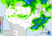


Short Range Loop

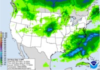
WPC's 6-Hour QPF loop, days 1-7: http://www.wpc.ncep.noaa.gov/qpf/qpfloop_6hr_d17.html
day 1...............................vs..............................day 2
Short Range Loop
Last edited by unome on Tue Apr 26, 2016 4:33 am, edited 1 time in total.
-
srainhoutx

- Site Admin

- Posts: 19616
- Joined: Tue Feb 02, 2010 2:32 pm
- Location: Maggie Valley, NC
- Contact:
Active weather week ahead as multiple impulses drop SE out of the Gulf of Alaska a carve out a deepening Western trough with plenty of cold air particularly at the upper levels. Rounds of Severe Storms should develop throughout the work week across the Plains extending S into Texas. Will need to watch Tuesday night into Wednesday and again Friday afternoon throughout Saturday as a weak frontal boundary slowly meanders S across the Lone Star State. The Weather Prediction Center has issued a Slight Risk for Excessive Rainfall for Day 2 across portions of our Region. We likely will see another Excessive Rainfall threat develop late week, so we encourage everyone to monitor the weather forecast daily for further updates.

- Attachments
-
Carla/Alicia/Jerry(In The Eye)/Michelle/Charley/Ivan/Dennis/Katrina/Rita/Wilma/Humberto/Ike/Harvey
Member: National Weather Association
Facebook.com/Weather Infinity
Twitter @WeatherInfinity
Member: National Weather Association
Facebook.com/Weather Infinity
Twitter @WeatherInfinity
-
srainhoutx
- Site Admin
- Posts: 19616
- Joined: Tue Feb 02, 2010 2:32 pm
- Location: Maggie Valley, NC
- Contact:
Monday morning briefing from Jeff:
Another potent upper level storm system to take aim at TX late this week into next weekend.
In a pattern that is starting to mirror 2015, the next in a series of upper level systems will begin to affect the state later this week into next weekend with a return of heavy rainfall and severe weather.
Before then a short wave will move across the area on Tuesday and Tuesday evening. Strong instability develops along and ahead of the central TX dry line and by late afternoon expect severe thunderstorms to develop along this feature. Main threat will be very large hail and damaging winds as storms move into the western sections of SE TX Tuesday evening. Main storms should stay west of I-45 and should be weakening as they progress eastward into SE TX.
Late Week:
Pattern appears to be shaping up somewhat similar to this past week as a blocking pattern develops aloft and another upper level system drops into the SW US and moisture levels rise to high levels across TX. Several disturbances will begin to rotate into the state on Friday with thunderstorms likely developing across SW TX into central TX Friday afternoon and evening. Storms will gradually shift into SE TX on Friday night into Saturday with a heavy rainfall and severe weather threat.
This period will have to be watched closely over the next few days given the sensitivity of the region to heavy rainfall at the moment.
Day 2 (Tuesday Severe Weather Outlook)
[/i]
Another potent upper level storm system to take aim at TX late this week into next weekend.
In a pattern that is starting to mirror 2015, the next in a series of upper level systems will begin to affect the state later this week into next weekend with a return of heavy rainfall and severe weather.
Before then a short wave will move across the area on Tuesday and Tuesday evening. Strong instability develops along and ahead of the central TX dry line and by late afternoon expect severe thunderstorms to develop along this feature. Main threat will be very large hail and damaging winds as storms move into the western sections of SE TX Tuesday evening. Main storms should stay west of I-45 and should be weakening as they progress eastward into SE TX.
Late Week:
Pattern appears to be shaping up somewhat similar to this past week as a blocking pattern develops aloft and another upper level system drops into the SW US and moisture levels rise to high levels across TX. Several disturbances will begin to rotate into the state on Friday with thunderstorms likely developing across SW TX into central TX Friday afternoon and evening. Storms will gradually shift into SE TX on Friday night into Saturday with a heavy rainfall and severe weather threat.
This period will have to be watched closely over the next few days given the sensitivity of the region to heavy rainfall at the moment.
Day 2 (Tuesday Severe Weather Outlook)
Carla/Alicia/Jerry(In The Eye)/Michelle/Charley/Ivan/Dennis/Katrina/Rita/Wilma/Humberto/Ike/Harvey
Member: National Weather Association
Facebook.com/Weather Infinity
Twitter @WeatherInfinity
Member: National Weather Association
Facebook.com/Weather Infinity
Twitter @WeatherInfinity

-
Andrew
- Site Admin
- Posts: 3440
- Joined: Wed Feb 03, 2010 9:46 pm
- Location: North-West Houston
- Contact:
Tomorrow I suspect the plains will see a rather large severe weather outbreak. Whether that will be a strong wind event or a tornado outbreak is still up to debate. What I do suspect will happen is the moderate risk will continue to expand further south. Models indicate that the influence of a vort max and associated LLJ will impact North Texas/ Southern Oklahoma right around 00z. This area could also provide a cleaner mid level wind profile when compared to Central Oklahoma. We see much more of a veering profile versus a veer-back-veer setup. Furthermore, storms that far south may stay more discrete longer instead of going fully linear. With that said, if we see a high risk I suspect that will occur over Kansas/Nebraska region where the triple point will help focus convection. Still have my reserves if that will actually happen though with a potentially delayed vort max/ messy mid level winds.
Moving south into Central and SE Texas I do suspect the line will have plenty of energy and upper level support to make it into the central parts of the state. While it will be weakening, I do think SE Texas will see a weak/broken line come through Tuesday night/Wednesday morning before it stalls somewhere along SE Texas.
Moving south into Central and SE Texas I do suspect the line will have plenty of energy and upper level support to make it into the central parts of the state. While it will be weakening, I do think SE Texas will see a weak/broken line come through Tuesday night/Wednesday morning before it stalls somewhere along SE Texas.
For Your Infinite Source For All Things Weather Visit Our Facebook


I would not be surprised either. This is Spring, which is most likely to see large severe weather outbreaks.Andrew wrote:Tomorrow I suspect the plains will see a rather large severe weather outbreak. Whether that will be a strong wind event or a tornado outbreak is still up to debate. What I do suspect will happen is the moderate risk will continue to expand further south. Models indicate that the influence of a vort max and associated LLJ will impact North Texas/ Southern Oklahoma right around 00z. This area could also provide a cleaner mid level wind profile when compared to Central Oklahoma. We see much more of a veering profile versus a veer-back-veer setup. Furthermore, storms that far south may stay more discrete longer instead of going fully linear. With that said, if we see a high risk I suspect that will occur over Kansas/Nebraska region where the triple point will help focus convection. Still have my reserves if that will actually happen though with a potentially delayed vort max/ messy mid level winds.
Moving south into Central and SE Texas I do suspect the line will have plenty of energy and upper level support to make it into the central parts of the state. While it will be weakening, I do think SE Texas will see a weak/broken line come through Tuesday night/Wednesday morning before it stalls somewhere along SE Texas.
our neighbors in Dallas, gearing up for a bumpy ride
area forecast discussion
national weather service fort worth tx
341 am cdt tue apr 26 2016
.discussion...
the last week of april through the first few days of may areshaping up to be an active period as a series of upper level storm systems move across the country. this morning/s satellite data indicates that the first system slated to affect the north and central texas is an upper low currently situated over the four corners region. a distinct vorticity lobe can be seen rotating around the southwest quadrant of the upper low over arizona. this feature will continue around the base of the system across new mexico this morning and then into northwest texas this afternoon... forcing the upper low to eject northeastward through the plains tonight.
the resulting negatively tilted appearance taken on by the upper level system is generally conducive for the development of strong to severe thunderstorms... particularly in the spring when other parameters associated with convection are more likely to become favorable. one such parameter will be low level convergence... which in this case will be enhanced as a dryline is nudged eastward into western counties of north and central texas. another will be instability... which is forecast to be in great supply as cape climbs to near 4000 j/kg in the vicinity of the dryline this afternoon. shear will be more than sufficient for the development of rotating cells capable of maintaining strong updrafts... which means that large hail will be our most likely severe threat. damaging downburst winds will also be a good possibility with any storms which becomes severe. low level shear does not look particularly great for an outbreak of tornadoes... but when combined with such good instability will be enough for a few tornadoes to occur.
the highest probabilities for severe thunderstorm development will be early on in the development of storms... or during the 4 to 10 pm time-frame when discrete cells are more likely to occur. location should initially be west of the interstate 35/35w corridor near the dry-line. upscale development into a linear convective mode is likely late this evening and overnight as storms shift east across the i-35 corridor and continue across the eastern half of the region. brief heavy rain and localized flooding will be another possible threat overnight... especially if any storms are able to train over the same areas. activity is expected to end from west to east during the morning hours on wednesday.
the next round of storms will occur late thursday as another upper low deepens over the four-corners region before lifting northeast through the plains. it looks like two main pieces of energy will be associated with this system... one of which will generate the thursday night storms... and the next which will generate a second round of convection friday night into early saturday. the convective parameters do not look quite as favorable as they do with this evenings/s system,... but still look sufficient for some severe weather both thursday night and friday night. saturated soils from the early-week storms will also increase the likelihood of localized flooding.
there should be a break in the activity late saturday and sunday as the system heads for the great lakes. on monday... a shortwave trough will propagate east along the red river region... generating yet another round of showers and thunderstorms. at this time... the gfs indicates that this will be a monday daytime event... while the ecmwf is about 12 hours slower... indicating a monday night event. we will show pops for both time periods and refine as models come into better agreement. either way... there looks to be a break in the active weather for the rest of next week as troughing deepens in the eastern conus and an upper ridge develops across the plains.
.aviation...
/issued 1136 pm cdt mon apr 25 2016/
a few thunderstorms managed to develop this evening to the southwest of kact and northwest of kaus. these storms did not last much past 03z... and things are relatively quiet for the time being. low level moisture continues to stream north... with dewpoints in the upper 60s and lower 70s across much of north and central texas. do expect to see additional areas of lower ceilings to approach the terminal sites... but not until 08-09z. winds will be fairly strong overnight... with southerly winds sustained around 15-20 knots...and there will be some higher gusts.
thunderstorm chances will then increase late in the afternoon on tuesday. have kept vcts for the terminal sties around 00z... with initiation a few hours earlier than this near the bowie cornerpost. expect to see a few discrete cells before 00z... before forming into a line which could affect the airports for a few hours between 00-04z.
fox
and a busy week in our area:
http://digital.weather.gov/?zoom=6&lat= ... its=localt
040
fxus64 khgx 260954
afdhgx
area forecast discussion
national weather service houston/galveston tx
454 am cdt tue apr 26 2016
.discussion...
the state falling downstream of an upper low currently located over the lower great basin. leeward rocky mountain pressures falling with the 995 mb surface low currently situated over sw kansas... dry line emanating from the trough into the panhandle and southward into the big bend region. the warm front extending eastward into the central plains placing the majority of the state under a warm air advection flow pattern. a tight onshore pressure gradient back to the 1016 mb florida-centric high is producing a moderate southerly wind that has aided in maintaining areawide low 70 dew points. southeastern u.s. mid-level ridging and rocky mountain low has produced an entrenched southwest wind. this mid-level steering flow has pulled in a warm air mass aloft... noted by the 8-9h layer capping inversion in both last night`s crp and shv soundings. the eastern movement of the great basin 5h low into the (central) western plains will draw the dry line into central texas tomorrow morning. a quasi-linear convective line will likely develop along the dry line this evening and this line will propagate east into northeast texas through the overnight wednesday morning hours. the model suite generally tracks this tsra line into the northern fringes of the cwa between 06 and 12z... but the strength of the downstream cap will ultimately become the decider. the target counties for either strong or severe storms will be madison... houston and trinity as the cap will likely weaken the most over the northeastern cwa. the wrf-arw does hold a qlcs together... possibly bowing out east of waco/i-35 corridor around midnight. the highest confidence lies with a weakening line that will travel across the forecast area from as early as late tonight through the early afternoon hours... the bulk of the 1 to 2 inches (locally 3 to 4 inches) of rain falling during the early morning hours. high mid-level lapse rates equating to high cape values with high low level bulk shear values... along with lower wbz heights... suggest the main threats will be wind and hail. the progressive nature of the storms will mute the high rainfall threat. there is decent lower level veering (35-45 llj) of wind that does produce a higher signal for tornadoes.
thursday`s vacating upper low into the great lakes region will quickly be filled by the next in-a-line of upper lows. this low is currently diving south out of the gulf of alaska and will dig down into the four corners region through late thursday into early friday. this low is currently being modeled to take a similar path as tomorrow`s low... maybe a touch more east than north. this will create better upper level diffulence over the arklatex region (than tomorroww`s system)... and this could be the marker that makes saturday`s system a potentially stronger system. but in not putting the cart before the horse... precipitation chances will be on the rise friday with a tightened onshore pressure gradient producing a robust 15-20 kt southerly surface wind. higher pockets of pva ahead of the desert southwest low suggest that friday could be plagued with periods of scattered showers and storms. the one inhibitor would again be the strength of the mid-level warm nose. the forecast calls for another qlcs passage saturday with profiles depicting wind and high rainfall rates as potentially higher threats.
until a cold front slated for the monday-tuesday time frame comes through... persistent onshore flow will ensure this muggy and warm weather pattern through the remainder of the month. morning minimum temperatures will range in the upper 60s to lower 70s with daytime readings warming into the average middle 80s on days where is doesn`t rain... lower 80s on those days it rains during the afternoon. 31
&&
.marine...
moderate onshore winds will continue this week. there will likely be intermittent fluctuations whereas caution and/or advisory flags will be required... this should be especially true later in the week as the pressure gradient further tightens and the fetch lengthens. corresponding wind speeds and seas will see a further upward bump going into the weekend. 47
&&
.aviation...
low level moisture remains trapped beneath capping inversion which should keep mvfr cigs in place into at least the morning hours. the nam12 and gfs differ with regards to how quickly heating will mix things out. the nam12 keeps cigs in place most of the day while the gfs mixes things out and eliminates cigs by mid-morning. continuing to lean toward the gfs soln for the 12z taf package. should start seeing se winds become gusty toward midday and persist thru the aftn. complex of tstms is expected to develop in n tx & ok later in the aftn. temp inversion/capping should limit severe wx chances locally... but tail end of of some of this weakening precip may make its way into the region late tonight. think previous fcsters vcsh mention looks good and will expand a bit swd with this package. 47
&&
.preliminary point temps/pops...
college station (cll) 87 69 84 67 86 / 10 60 30 10 20
houston (iah) 85 72 85 71 86 / 10 50 50 10 20
galveston (gls) 82 73 79 74 82 / 10 20 50 20 20
&&
.hgx watches/warnings/advisories...
tx... none. gm... small craft should exercise caution until 10 am cdt this morning for the following zones: galveston bay... matagorda bay... waters from freeport to the matagorda ship channel 20 nm to 60 nm... waters from freeport to the matagorda ship channel out 20 nm... waters from high island to freeport 20 to 60 nm... waters from high island to freeport out 20 nm.
&&
$$
discussion...31/47