

Does it show the intensity?Scott747 wrote:Oz hwrf into port lavaca.
August 2017: Looking Back at Harvey 5 Year Later
-
brooksgarner

- Global Moderator

- Posts: 226
- Joined: Tue Jun 04, 2013 3:06 pm
- Location: Houston, TX
- Contact:
00z NAM simulated radar at 7am Friday morning. Little value, just interesting intensity forecast.
Broadcast Met
http://BrooksGarner.com
http://twitter.com/BrooksWeather
http://BrooksGarner.com
http://twitter.com/BrooksWeather
- '17 Harvey
- '12 Sandy (P3 Orion)
- '91 Bob
- '85 Gloria
970. Probably around 70 its.sambucol wrote:Does it show the intensity?Scott747 wrote:Oz hwrf into port lavaca.

yep and then harvey wanders northeastward toward college station.Scott747 wrote:Oz hwrf into port lavaca.
hmon follows the cmc and after landfall takes harvey southwestward into mexico.

~~~When Thunder Roars Go Indoors~~~
~~~Turn Around Don't Drown~~~
~~~Run From The Water, Hide From The Wind~~~
~~~Turn Around Don't Drown~~~
~~~Run From The Water, Hide From The Wind~~~
0a Euro is further n and e plus a touch stronger through hr 48. Even looked to be initialized a little to far s.
-
Texaspirate11

- Posts: 1278
- Joined: Tue Dec 31, 2013 12:24 am
- Contact:
HGX :
Just because you're disabled, you don't have to be a victim
Be Weather Aware & Prepared!
Barbara Jordan Winner in Media
Disability Integration Consultant
Be Weather Aware & Prepared!
Barbara Jordan Winner in Media
Disability Integration Consultant

hr 120 on the Euro 0z hugging the coast


0z Euro still shows widespread rainfall amounts of 10-15+ inches across the area...
-
Andrew
- Site Admin

- Posts: 3440
- Joined: Wed Feb 03, 2010 9:46 pm
- Location: North-West Houston
- Contact:
00z Euro comes in line with the GFS as a strong TS/weak hurricane south of Matagorda Bay. Then stalls and heads southeast before ejecting to the east. Looks to be widespread 10-15 inches with isolated 20 inches.
For Your Infinite Source For All Things Weather Visit Our Facebook
-
srainhoutx

- Site Admin
- Posts: 19616
- Joined: Tue Feb 02, 2010 2:32 pm
- Location: Maggie Valley, NC
- Contact:
Morning Updated 7 Day Quantitative Precipitation Forecast which does keep rainfall in our forecast throughout the entire 7 Day period.
- Attachments
-
Carla/Alicia/Jerry(In The Eye)/Michelle/Charley/Ivan/Dennis/Katrina/Rita/Wilma/Humberto/Ike/Harvey
Member: National Weather Association
Facebook.com/Weather Infinity
Twitter @WeatherInfinity
Member: National Weather Association
Facebook.com/Weather Infinity
Twitter @WeatherInfinity
-
srainhoutx
- Site Admin
- Posts: 19616
- Joined: Tue Feb 02, 2010 2:32 pm
- Location: Maggie Valley, NC
- Contact:
Worrisome to see the very nearly stationary Harvey trapped over our Region throughout the weekend into early next week. Stalled frontal boundary with no steering current to move Harvey away spells potential for prolific rainfall totals.
Carla/Alicia/Jerry(In The Eye)/Michelle/Charley/Ivan/Dennis/Katrina/Rita/Wilma/Humberto/Ike/Harvey
Member: National Weather Association
Facebook.com/Weather Infinity
Twitter @WeatherInfinity
Member: National Weather Association
Facebook.com/Weather Infinity
Twitter @WeatherInfinity
6z gfs is ever so slightly to the w. Still slowly moves n after landfall with little change in the potential rainfall as the 0z run.
Recon is also in the, about half way down. Should have a pass through any possible center in time for the 7 am outlook.
Recon is also in the, about half way down. Should have a pass through any possible center in time for the 7 am outlook.
-
srainhoutx
- Site Admin
- Posts: 19616
- Joined: Tue Feb 02, 2010 2:32 pm
- Location: Maggie Valley, NC
- Contact:
Scott747 wrote:6z gfs is ever so slightly to the w. Still slowly moves n after landfall with little change in the potential rainfall as the 0z run.
Recon is also in the, about half way down. Should have a pass through any possible center in time for the 7 am outlook.
- Attachments
-
Carla/Alicia/Jerry(In The Eye)/Michelle/Charley/Ivan/Dennis/Katrina/Rita/Wilma/Humberto/Ike/Harvey
Member: National Weather Association
Facebook.com/Weather Infinity
Twitter @WeatherInfinity
Member: National Weather Association
Facebook.com/Weather Infinity
Twitter @WeatherInfinity
-
Katdaddy

- Global Moderator
- Posts: 2502
- Joined: Thu Feb 04, 2010 8:18 am
- Location: League City, Tx
- Contact:
Harvey's remnants continue to slowly organize with models continuing to show the Middle and Upper TX Coast as a landfall. Of much concern as Srain noted is the potential for widespread significant flooding across the Upper TX Coast and SE TX. Today is the day to finalize your hurricane plans.
This hazardous weather outlook is for portions of Southeast Texas..
.DAY ONE...Tonight
No significant weather expected.
.DAYS TWO THROUGH SEVEN...Wednesday through Monday
The National Hurricane Center is continuing to monitor the remnants
of tropical system Harvey. The environment that Harvey will move
through over the Gulf will be very favorable for intensification
and the system could become a tropical storm or hurricane. This
system is expected to move from the Yucatan Peninsula early
Wednesday and spread into Texas on Friday then slow down over the
region. A slow moving tropical system such as this can produce
copious tropical rainfall amounts. Slow moving storms have
produced amounts in excess of 20 inches leading to widespread
dangerous flooding. In addition with tropical systems come high
winds possibly of tropical storm or hurricane force including
tornadoes and storm surge. High tides along the upper Texas Coast
will likely cause impacts from dangerous rip currents to storm
surge flooding. The range of possibilities with storm surge are
varied given the highly uncertain track of the system. Evacuations
may be possible.
Marine impacts will include high winds and large dangerous seas
possible by Friday again depending on the strength and track of
the system.
Persons in Southeast Texas should be monitoring the weather
closely this week.
.SPOTTER INFORMATION STATEMENT...
Spotter activation is likely at some point between Thursday night
and Sunday.
-
srainhoutx
- Site Admin
- Posts: 19616
- Joined: Tue Feb 02, 2010 2:32 pm
- Location: Maggie Valley, NC
- Contact:
Wednesday early morning briefing from Jeff:
***Hurricane/ Tropical Storm landfall along the TX coast likely Friday evening***
***Increasing potential for widespread excessive rainfall and flooding***
Discussion:
Satellite images show that the remains of Harvey are gradually becoming better organized over the waters of the southern Gulf of Mexico just WNW/NW of the NW tip of the Yucatan. Convection has been developing this morning around the broad low level circulation. A USAF mission is currently enroute and should begin to provide better data on if a tropical depression has formed around 630-700am this morning. NOAA high altitude mission yesterday evening dropped 30 sondes across a large portion of the Gulf of Mexico including some just west of the system. Some of the data just west of the circulation shows a large mass of dry air that may be helping to inhibit near term development some. Large amounts of moisture are moving into the central Gulf of Mexico along a trough axis that extends northward from Harvey into the northern Gulf resulting in numerous showers and thunderstorms well north of the circulation.
Track:
All high altitude data and special balloon launches from southern NWS offices went into the 00Z model data. There has been a very slight shift eastward (right) in the model consensus with a track near the western edge of Matagorda Bay possibly near Seadrift for a landfall. Looking at the last 4 cycles of models there is not been that much shifting of the consensus track of the major global models so confidence is starting to increase for a landfall between north of Corpus Christi to Matagorda Bay
Weak and complex steering begins to develop as Harvey nears the coast and moves inland Friday evening. High pressure builds into NW TX from the SW US blocking the continued NW motion of Harvey while at the same time high pressure builds across the central US Gulf coast with a trough extending from the NE US WSW to eastern TX. Harvey will become trapped in the weak steering flow regime over TX by Saturday where the forward motion will slow and possibly the system will stall somewhere between Austin and Victoria. It appears the system will then turn ENE along the tail end of the trough over east TX and slowly drift over SE TX and into SW LA. There are a few (including some of our major global models) that slow the system near the coast and then move it ENE/NE along the middle and upper TX coast which is possible. This would keep a much stronger storm in play versus one that would move inland.
Intensity:
Conditions appear favorable for intensification of Harvey up to landfall on the TX coast. All parameters appear to be satisfied including warm SST’s, 200mb high pressure over the center of the system, potential dual outflow channels to the NE and SW of the center. It is possible that a period of rapid intensification could occur as Harvey nears the middle TX coast on Friday. Intensity forecast skills are poor especially when dealing with rapid intensification…this aspect will need to be monitored closely on Thursday and Friday as Harvey approaches. General consensus currently is for a strong tropical storm or weak hurricane into the middle TX coast Friday evening.
Impacts:
Below impacts are based on the consensus model tracks and a blending of major model QPF and WPC guidance. There has been little change in the storm surge or wind portions of this since yesterday afternoon. Rainfall has been increased to better match WPC grids
It should clearly be noted that the potential for widespread excessive rainfall over multiple days is becoming increasing likely and that significant flooding may result over a large area of SE TX and the coastal bend region.
Rainfall:
Major global models have not backed away from some very impressive rainfall totals and the overall pattern with a slow moving/meandering tropical system certainly support these totals. WPC has raised the QPF for the entire region into the 10-12 inch range and certainly isolated totals will be higher. Rainfall of this magnitude will result in widespread and potentially dangerous flooding. River, creek, and bayou flooding along with flash flooding will all be possible late Friday through the weekend
Widespread: 10-12 inches (all areas)
Isolated: 20 inches +
A quick look back this morning does show that tropical systems in weak steering pattern have produced devastating rainfall over TX before:
TS Allison: 28.5 inches in 12 hrs (NE Harris County)
TS Claudette: 43.0 inches in 24 hrs (Alvin, TX)
TS Amelia (1978): 50.0 inches (72 hrs) over Medina and Kerr Counties
Unnamed (1921): 36.40 inches (18 hrs) Thrall, TX
Storm Surge:
Will start to see increasing tides Thursday afternoon and possible we may hit 3.0 ft total water level Thursday afternoon/evening especially Matagorda Bay southward toward Mustang Island. Will go with total water levels Friday rising to 4.0-5.0 feet along all of the upper and middle coast and likely nearing 5.0 feet around Matagorda Bay. 4.5 feet is our critical warning threshold along much of the upper coast for the start of impacts and think we will hit those levels on Friday especially Matagorda Bay. Overwash and coastal flooding appears likely Friday from Palacios southward including Matagorda Island and along the west side of Matagorda Bay.
Tides will increase Friday night across the coast NE of Palacios as SE winds pile water and wave action onto the coast. Will build to 4.0-5.0 feet Friday night along Brazoria, Galveston, and SE Harris coast with overwash likely on the west end of Galveston and Bolivar. With the continued onshore flow well into Saturday and Sunday tides will only worsen over the weekend as water becomes trapped in the bays…especially the western side of Galveston Bay. Certainly looking at potential coastal flooding around Clear Lake, Kemah, Seabrook, Galveston Island, Bolivar on Saturday…but don’t want to go much more than 4.5-5.5 feet total water level at this time as a lot of factors are in play.
Matagorda Bay: 4-5 ft (Friday/Saturday)
Galveston Bay: 4-5 ft (late Friday/Saturday)
Gulf Beaches: 4-5 ft (Friday/Saturday)
Onset of 3.0 ft total water level rise Thursday afternoon/evening
Note: Should the system slow or meander near the coast tides would possibly need to be raised some from Matagorda County NE as this would allow a greater period of time for onshore winds to pile water over several tide cycles.
Winds:
Still some uncertainty with the winds as to how strong the system becomes and how far inland it moves. If Harvey gets trapped closer to the coast it will not weaken as fast as if it moves further inland
Tropical storm conditions (40mph sustained) will begin to reach the middle coast on Friday around midday and spread inland into the evening hours. Will bring Jackson, Matagorda, Calhoun, Victoria, Aransas, Refugio, San Patricio, and Wharton Counties into the TS force winds by Friday evening and build to hurricane force (75mph sustained) over Calhoun, Aransas, and Refugio Counties Friday night. Could be very near hurricane conditions into much of Matagorda Bay Friday night and possibly Matagorda County with tropical storm conditions up to Galveston by Saturday morning.
Wind forecast moving forward into Saturday and Sunday will greatly depend on if the system moves inland over the western portions of SE TX or remains closer to the coast. A system closer to the coast would likely weaken much slower and keep stronger winds for a longer period of time along the coast and spread gradually ENE up the coast over the weekend.
Actions:
Hurricane plans should be fully prepared to be enacted today and Thursday including fully stocked hurricane kits.
Ride out teams should be notified and activation of COOP’s is recommended.
Preparations should include the potential for loss of power and prolonged excessive rainfall and flooding along with prolonged high coastal tides. Some areas near the coast may become cut-off as early as Friday.
Significant rises on area rivers, creeks, and bayous is a real threat and residents living in flood prone areas should be prepared for rising water and potentially significant flooding.
Note:
Tropical storm, hurricane, and storm surge watches and/or warnings may be required for portions of the TX coast today or Thursday.
- Attachments
-
-
-
Carla/Alicia/Jerry(In The Eye)/Michelle/Charley/Ivan/Dennis/Katrina/Rita/Wilma/Humberto/Ike/Harvey
Member: National Weather Association
Facebook.com/Weather Infinity
Twitter @WeatherInfinity
Member: National Weather Association
Facebook.com/Weather Infinity
Twitter @WeatherInfinity
-
srainhoutx
- Site Admin
- Posts: 19616
- Joined: Tue Feb 02, 2010 2:32 pm
- Location: Maggie Valley, NC
- Contact:
Satellite Imagery suggests Harvey may be organizing somewhat. Starting to see some evidence of dry air to its West moistening some with a bit of early banding features. It looks like both a Northern and Southern Outflow channels are beginning to take shape. Convection is attempting to develop, although spotty. RECON should arrive shortly to determine if the board surface low has closed off.
- Attachments
-
- 20170823.1100.goes13.x.wv1km.09LHARVEY.25kts-1009mb-208N-915W.100pc.jpg (42.33 KiB) Viewed 4072 times
Carla/Alicia/Jerry(In The Eye)/Michelle/Charley/Ivan/Dennis/Katrina/Rita/Wilma/Humberto/Ike/Harvey
Member: National Weather Association
Facebook.com/Weather Infinity
Twitter @WeatherInfinity
Member: National Weather Association
Facebook.com/Weather Infinity
Twitter @WeatherInfinity
When will at least a watch go up? I know it's officially not a storm right now but we are getting very close to this affecting our area.

-
srainhoutx
- Site Admin
- Posts: 19616
- Joined: Tue Feb 02, 2010 2:32 pm
- Location: Maggie Valley, NC
- Contact:
With the 7:00AM CDT TWO I suspect within the next 24 hours...if not sooner. RECON has found a broad closed low pressure at the surface with plenty of West winds. Still organizing, but appears to be on its way.sambucol wrote:When will at least a watch go up? I know it's officially not a storm right now but we are getting very close to this affecting our area.
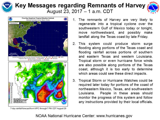
Tropical Weather Outlook
NWS National Hurricane Center Miami FL
800 AM EDT Wed Aug 23 2017
For the North Atlantic...Caribbean Sea and the Gulf of Mexico:
1. Satellite images, reconnaissance data and surface observations
indicate that the remmants of Harvey are close to redeveloping into
a tropical depression over the southwestern Gulf of Mexico about 150
miles west of Merida, Mexico. The Advisories will likely be re-initiated
at 10 am CDT on this system. low is forecast to move to the
northwest at about 10 mph across the western Gulf of Mexico,
possibly reaching the northwestern Gulf coast late Friday. This
system is likely to slow down once it reaches the coast, increasing
the threat of a prolonged period of heavy rainfall and flooding
across portions of Texas and Louisiana into early next week. Harvey
could also produce storm surge and tropical storm or hurricane force
winds along portions of the Texas coast later this week, and
Tropical Storm or Hurricane Watches could be required later today
for portions of the coast of northeastern Mexico, Texas, and
southwestern Louisiana. Interests in these areas should monitor the
progress of this system and refer to products issued by your local
National Weather Service office for more information.
* Formation chance through 48 hours...high...near 100 percent.
* Formation chance through 5 days...high...near 100 percent.
- Attachments
-
Carla/Alicia/Jerry(In The Eye)/Michelle/Charley/Ivan/Dennis/Katrina/Rita/Wilma/Humberto/Ike/Harvey
Member: National Weather Association
Facebook.com/Weather Infinity
Twitter @WeatherInfinity
Member: National Weather Association
Facebook.com/Weather Infinity
Twitter @WeatherInfinity